An interesting set up
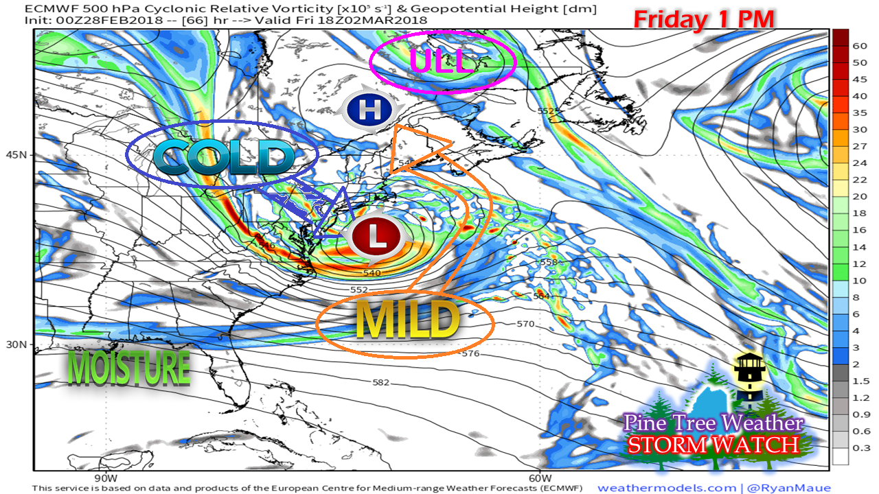
Usually in storm set ups like this one, the buzzword "blizzard" would be thrown around like penny candy in a summer parade. That will likely be the case for much of New York state and a considerable part of southern New England. There is a possibility of heavy wet snow for parts of western and southern interior Maine. I won't rule that out as I think most of the models are missing on the cold with this event. The key in all of this is the position of the upper level low over northeast Quebec and high pressure near the St. Lawrence River. I believe those two ingredients hold the cards on how this plays out. If the high and upper low are further east, there would likely be a need for a yard stick to measure the snowfall from this event. There is plenty of energy, plenty of Gulf of Mexico moisture, but the deep cold is to the north and west. It's worthy to note that this storm is likely to contain a cold core to it, which means the idea of snow for cannot be ruled out. While that gets sorted out, there is still plenty to be concerned about with this event. Wind could cause power outages
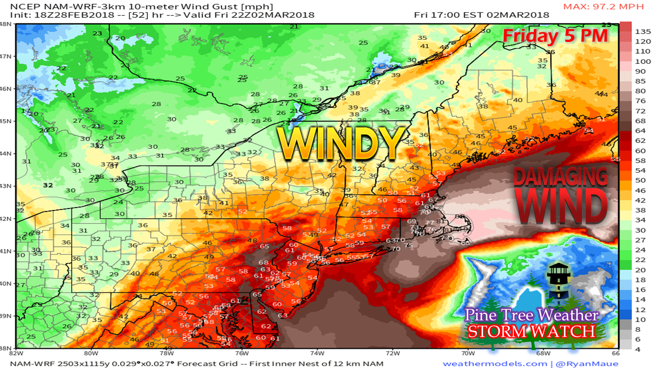
I'll be blunt about this and say this for southern New England followers that you are likely to get hammered with this storm. Folks from the north shore to Cape Cod, Nantucket and Martha's Vineyard should buckle up. High Wind Watches are already posted from coastal York County around the Cape all the way to the Outer Banks of Cape Hatteras. Gusts in the 50-60 mph range (potentially higher) are likely from Friday morning into Saturday, pending on region. Add the potential of heavy wet snow for interior areas, this could be a big problem for much of the northeast corridor. The ocean is going to get ugly... for days
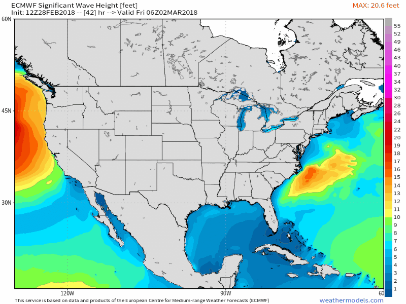
Coastal areas are going to take a beating. As the title of the post says, this is a long duration event. The storm will be stuck in a traffic jam over the Atlantic and hang around through early next week. Guidance is hinting at a central pressure of around 965 mb, which if this were a hurricane, would make it a Category 2 on the Saffir-Simpson scale. While it won't be a hurricane, the effects on the ocean will be very similar with waves exceeding 30 feet and hurricane force wind gusts offshore. 
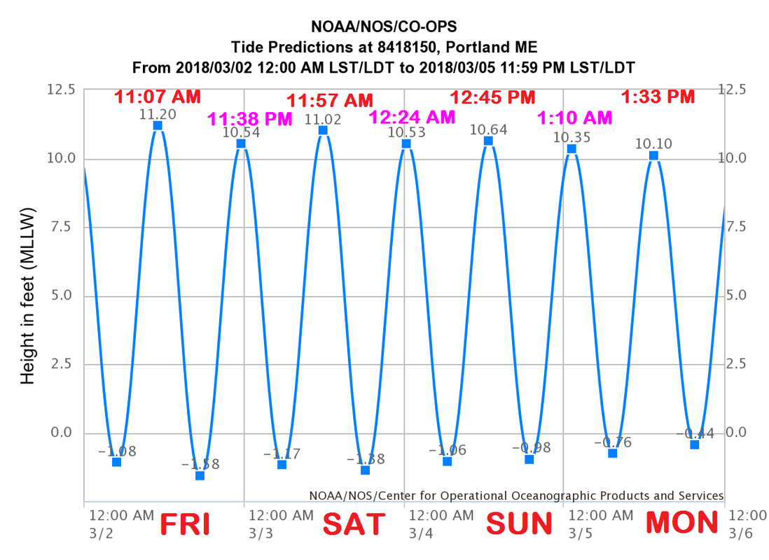
Given the fact that is appears to be a long duration event, there are several tide cycles to be concerned with. Tides are astronomically high due to the full moon. Tides in Portland will be running over 10 feet through Monday. For Eastport, you can double that to 20 feet. Coastal flood watches have already been posted for MidCoast and southwest coast, and time will tell if they will be needed DownEast. It won't be until Monday before the seas show signs of settling down. Storm surge could range 1-3', with the higher level over southwest areas. Mariners are advised to stay in port and take the weekend off. Stay in touch with the latest marine forecasts from NWS Caribou for DownEast areas, NWS Gray for the MidCoast and southwest coast of Maine, along with coastal New Hampshire. If you want to take a peek at how ugly it will be offshore, you can check the latest from the Ocean Prediction Center. 
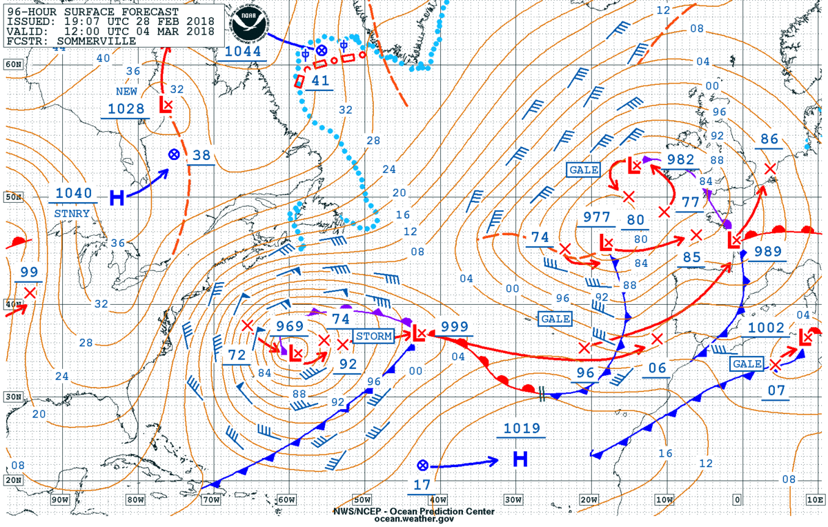
Speaking of the Ocean Prediction Center, this forecast from around 2 PM Wednesday looking ahead to 7 AM Sunday shows the storm south/southeast of Nova Scotia, still very strong and with plenty of wind. It will slowly weaken and move eastward into Monday. As it does, the seas and shoreline winds will begin to settle down. And about precipitation type...
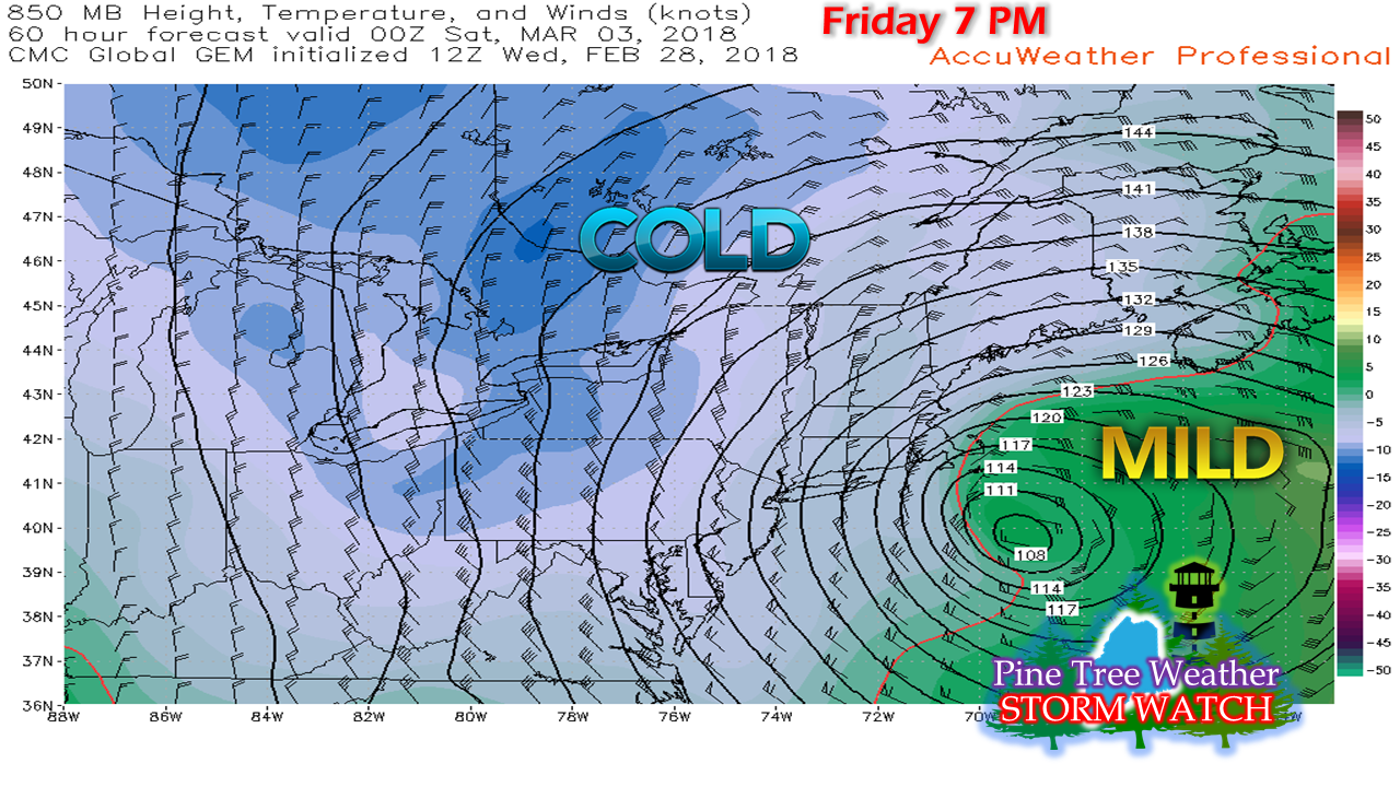
There is still much uncertainty on how much of what type precipitation will fall and where. There are plenty of questions and not many answers at this point on what the impact will be for Maine. There are several ideas on the table, and all are track dependent. Most guidance has the storm near the benchmark 40°N / 70°W point, which causes concern for me. To add to my concern is high pressure situated near the St. Lawrence River. While the storm appears to be throwing warm, moist air in at the surface, the question remains as to what happens at the mid and lower levels of the atmosphere. While surface temperatures could be above freezing to near 40°, that does not mean snow is unlikely. This idea from the Canadian model is an outlier, but it highlights my concern that some of the models are running too warm with this event. This chart indicates potential temperature at roughly 5,000 feet above sea level. Checking with the GFS model, which typically runs on the cool side, it shows similar ideas and takes the cold down to around the 1,700 foot level. With cold high pressure lurking to the north and a strong storm to the south, I become concerned that cold air will bleed in and turn interior areas into snowfall. There is a fair amount of confidence that areas north of Route 2 could see some snowfall. The game at this point is to figure out how close to the coast it gets. For now, it appears to be an elevation game. Hills over 1000 feet have a good chance for snow. It all depends on how low the cold ceiling falls for areas less than that altimeter. Folks who live in the foothills and coastal interior should pay special attention to the forecast Thursday into Friday to see how this all plays out. Personal updateThe good news is the new home purchase is about complete. The current home sale is underway. I still have no idea when the move will take place as of yet. That will be contingent upon the sale of our current home, or when my youngest daughter finishes school for the year, which ever comes first. I appreciate you hanging in there with me, and I look forward to where I can spend more time with weather updates.
As always, stay in touch with NWS Gray and NWS Caribou, and for you southern New England followers, NWS Boston for all the latest official bulletins and information. Thanks as always for your support. - Mike A taste of spring comes with a costWhile the winter weary members of the population are likely to embrace the forecast, this is one that certainly comes with side effects. Anytime warm air of this form comes with a snow pack and frozen rivers, flood potential is the first red flag that is raised. A good portion of southern and western areas could see as long as 72 hours of above freezing temperatures, which makes the potential flood threat even greater. With some rivers already jammed with ice from the January thaw, the abnormally warm air along with its duration could pose problems to tributaries through the middle part of the week. For those who live or work near rivers, brooks or streams, it would be wise to pay attention for rising water and ice jam potential that could make flood potential a reality. Also, for those who travel in low lying areas that are susceptible to spring or heavy rain flooding should think of possible alternate routes through later in the week. With all of this melting, the frost heaves and mud could make for rough and messy travel in areas as well. And then winter returns...While it is early to get into specifics, it would be wise to pay attention to the forecast in the coming days for a couple rounds of snow. The first would be for the mountains and north country Friday into Saturday, and then everyone gets in on the game Sunday into Monday. It all depends on actual storm track and storm intensity. For now, it is strictly an idea, and one to keep an eye on. Status UpdateThe last couple of weeks have been rather hectic at times in preparation to relocate this spring. Between the work on the purchase of one home and the selling of our current dwelling, my time has been very limited for weather updates and information. At this time, we are not exactly sure when moving day will come. When time permits, I will post some sort of an update to keep you abreast of potential weather concerns and a better timeline of when the move south to Kennebunk will occur.
You can always follow me on Twitter for any brief snippets of information that I may be able to pass along. I apologize in advance in case I do not respond to comments or messages on Facebook or tweets in a timely manner. I appreciate your patience while this process continues. Please stay updated on the forecast and any bulletins through the National Weather Service and/or the local broadcast media. - Mike Slight revision of the forecast mapJust a slight tweak to the map I posted here yesterday as a coastal front is likely to impact the coast. The southwest coast may see a touch of ice before all is said and done, but this is a predominantly a snow event.
Snowfall rates in the 1-2+" per hour along with wind gusts in the 20-30 mph range are likely to make travel difficult heading into the evening commute. Snow ends from southwest to northeast Wednesday evening into early Thursday morning. Word the wise, get to where you are going by early to mid-afternoon and stay there. Plow crews may have a tough time keeping up with this one for a few hours until the snow tapers off overnight. Everything else posted yesterday remains on track. - Mike Quick hitter to dump snowWhile this storm will not last long, it will bring a snowy punch to the state. The combination of upper level energy to the northwest, a southern stream pumping in rich moisture out ahead of it puts Maine in the cross hairs. While the traditional morning drive time will be alright, it will goes down hill rather quick as we head into the afternoon. Don't let the suggested precipitation outlook from the NAM model here fool you, this is on track to be a full on snow event. What is green and yellow indicating rain is likely by-in-large to be blue with snow being the rule. As quickly as the storm comes, it will end. Southern areas see snow end by mid-evening Wednesday night, with far northern areas seeing the last of the snow showers exiting before daylight on Thursday. Wednesday evening drive to be impactedAgain, the morning drive looks good, but from around noon onward, snow intensifies and falls rapidly. Snowfall rates in the 1-2+" range are likely as the evening drive approaches. As much as 6-8" of fresh snow is likely to be on the ground over southern areas as we approach 6 PM. For the Bangor area, expect 3-5" down by evening. A bit of wind to reduce visibilityIn conjunction with the heavy snowfall comes a breeze to go with it. While certainly not a blizzard, it will be windy enough to cause whiteout conditions in areas as the snow rapidly falls. Wind will also play a role into Thursday on the backside of the system, which is likely to cause blowing and drifting of snow through the day. Gusts could range in the 30-35 mph range across much of the region. Total snowfallAll in all, as solid snow event for most of the region with 8-14" likely for much of the state. The northwest crown around the Allagash appears to be on the light end of this one. The extreme southwest coast in York County and the DownEast shorelines may see a bit of a mix or wetter snow from a coastal front which may knock totals down there a bit. The next system of concern appears Sunday and that could be a warm event for the coast. Stay in touch with the forecast for the latest on that. Relocation process continuesThis is a very busy time for my family as we are in the process of preparing to move from Poland Spring to Kennebunk. The sort, save, sell and purge phase is going strong. This is consuming much of my time, along with day job responsibilities. This is certainly a process, and not an event. I will update here when I can. You can always follow me on Twitter for any quick hits of information that I have time to pass along. For you Facebook followers, be sure to have page notifications turned on in order to get information there. I will update when time permits until the moving process is complete.
Thank you for your understanding and support. - Mike |
Mike HaggettSeven year forecaster. Archives
January 2019
Categories |
Proudly powered by Weebly