
Enjoy the current weather as much as you can The rest of the week through Saturday appears dry and pleasant, with low humidity and comfortable temperatures. The pattern changes after that, with periodic showers and thunderstorms from Sunday onward. The dry pattern is going into hiatus, and the area is predicted to receive some much needed rainfall for most, if not all of next week. For those who have outdoor vacation plans during the last full week of July, you may want to consider indoor ideas instead. A pattern change for the wetter Many of the players of how the rest of this week and next are already on the playing surface. The deep trough keeps the region dry and free of the humidity through Saturday. A tropical disturbance over the central Gulf coast will advance northeastward later this week and help kick off the damp period ahead on Sunday. If you are doing a bit of a double-take by looking at this water vapor image and thinking it looks sort of like winter, you're right on the money. A blocking high to the east over the North Atlantic, a deep trough over the central part of the continent, and a steep ridge to the west. If this were winter, we'd likely get buried in this kind of set up. Since it is summer, we'll get wet instead. A kink in the trough changes the forecast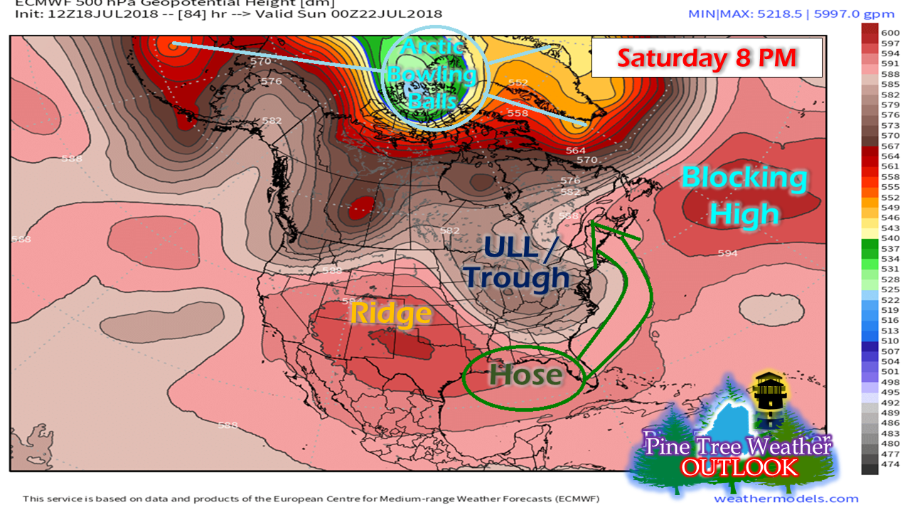 By Saturday evening, the pattern begins to change. The trough and associated upper level low that funnels down from western Canada sets up shop over the Great Lakes and MidAtlantic. The blocking high shifts eastward. The combination of all of that causes the trough to negatively tilt. Under this scenario, as in winter, that sets up the moisture hose and the upper air pattern to pump moisture and disturbances into the region. The humidity that left us Tuesday night into Wednesday backs in as a result of the blocking high shifting east. The result of that comes in the form of showers and thunderstorms. The region gets stuck in the pattern for days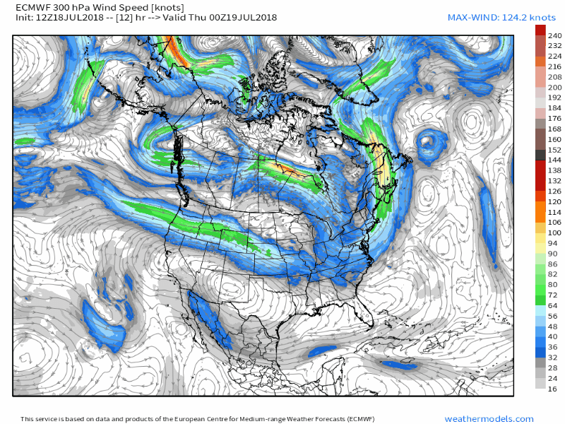 Taking a look at the jet stream wind pattern through late next week, starting on Sunday, the pattern doesn't move a whole lot. The blocking high over the North Atlantic wobbles a bit here and there, but really doesn't go anywhere, either. The week won't be an entire washout as it appears for now, but rain, showers and/or thunderstorms can be expected every day from Sunday through the late part of next week, and may continue into the last full weekend in July. The period appears humid through the entire week. Rainfall outlook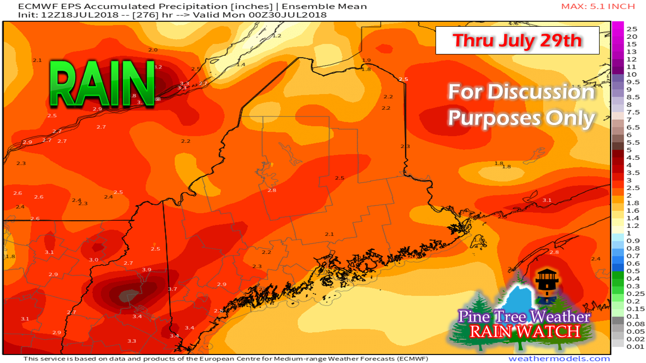 I don't normally post long term outlooks for precipitation since more times than not they end up less than the eventual outcome. I am also very sensitive to those who are in desperate need of rain, and do not want to get their hopes up just to be disappointed when they don't get it. However, given the pattern the region is heading into, there is fair confidence that the region could see upwards of 2" of rain in the coming 10-12 days or so. This is strictly a general idea. With the forecast stall of the jet stream and associated frontal boundary which appears to keep it's tropical hose attached, this is a reasonable outcome. Some areas will get more, others less in any areas of downpours. The idea of potential flood concerns off and on comes to mind here. Severe weather chances are certainly possible given the tropical air mass that appears to park itself over the region for several days.
Specifics will come as the time moves along. At the very least, expect a wet time of it from Sunday until further notice. Enjoy the good weather while it lasts. For the latest bulletins, advisories and forecast information, please check in with the National Weather Service in Caribou for eastern and northern areas, or Gray for western and southern regions. For more information from me, please follow the Pine Tree Weather Facebook page and check my Twitter feed. Thanks as always for your support! - Mike |

Mike Haggett
|


