Pine Tree Weather
  • DISCUSSIONS
  • DONATE
  • WEATHER WALL
  • MAPS
  • RAIN OUTLOOK
  • SEVERE
  • MARINE
  • CPC OUTLOOK
  • Kennebunk
  • MY BIO
  • PTW IN MEDIA
  • OBSERVING WEATHER
  • INTERNSHIPS
  • INTERN ALUMNI
  • DISCUSSIONS
  • DONATE
  • WEATHER WALL
  • MAPS
  • RAIN OUTLOOK
  • SEVERE
  • MARINE
  • CPC OUTLOOK
  • Kennebunk
  • MY BIO
  • PTW IN MEDIA
  • OBSERVING WEATHER
  • INTERNSHIPS
  • INTERN ALUMNI

A blizzard for the coast that will be remembered

1/29/2022

Comments

 
Picture
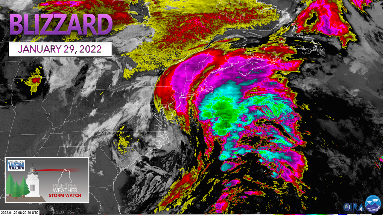
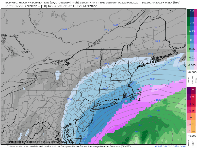
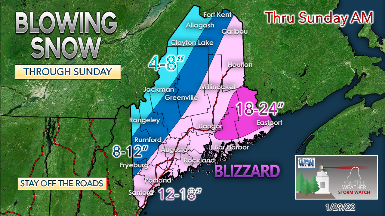
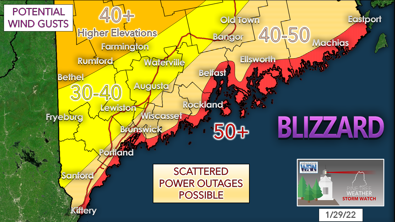
There is no question that the region has seen bigger storms with more impacts than what Maine is likely to get with this one. Most folks will remember a blizzard for a variety of reasons. I see this one is likely to be no different. Whether it is the drifts, the wind, the loss of visibility of seeing the neighbors or objects in the yard from the heavy snow, or perhaps what you did or was unable to do on the day it came. I've always loved a good storm, and that is what is happening here. 

In Friday's discussion I mentioned concerns about convection and weak low pressure on the eastern flank of the storm. This satellite image from around 4 AM Saturday shows the deep greens of convection. There is some serious cold being injected into this storm, and the warm air lifting into it is reacting to it. 

​Temperatures are going to drop through the course of the day as the northeast wind hauls down cold air from Eastern Quebec. If not for the volume of snow and the wind, the wind chill is the other story here. Most everywhere will be below zero as the storm amps up and stays that way into Sunday morning.  

Forecast remains on track
​along with the caveats of concern

Picture
Saturday 5 AM to Sunday 7 AM - Looking over several different model ideas from the short-term models has me return to the European idea depicted here for track purposes. There haven't been any real changes in track or intensity. The critical point for this storm is as the low rounds the horn of Cape Cod by around noon and heads into the Gulf of Maine. That is when the storm brings heavy banding with snowfall rates 1-3" per hour and the strongest wind. Once the storm. The storm becomes vertically stacked, the inflow of warm air and moisture are cut off with the occlusion, and the system begins to slowly weaken as it drifts northeastward by Saturday evening. 

Folks along the DownEast shorelines may be treated to a rumble or two of thunder before the occlusion occurs as the center of low pressure moves closer to Penobscot Bay. 

This is a fun day to watch your barometer. Locals following in the Kennebunk region can follow my observations and that of Dutch Elm Golf Course for wind on Kennebunk page. 
Picture
No changes to the forecast snowfall idea.

There are valid arguments why totals could be lower for the mountains and north due to bone dry air drinking up what moisture moves in aloft. 

The idea of an earlier occlusion of an hour to two, while unlikely, is possible, which would allow a dry slot to work in. There is also the element that a weaker low to the east may tug the storm in that direction, which is another factor why snow totals end up lower in the fringe area.

Wind shear in the snow growth zone (DGZ) is likely to whip at 90-100 knots. Snowflakes generated in that violent situation are likely to be well beaten up by the time they land on terra firma. That could alter totals as well.

As I said in the Friday update, for the coast and eastern areas, this snow from this storm won't be measured by what is on the ground, but by the feet of the drifts. 
Picture
No changes to the wind. There are two sides of this, the northeast side as the storm moves in, and the northwest side as the storm moves away. Snow continues to blow and drift through Sunday midday for southern areas, and it may be early Monday before the wind settles enough to end the drifting over the mountains, north and east. 

Power outages potential is in the isolated to scattered range. What outages occur are likely to be caused by falling tree limbs from the wind. Trees are frozen in the ground at this point, and with the powder snow, I continue to see no widespread outage impacts.

If you do lose power, it may take a while for restoration given the blizzard conditions.  
Picture
Shoreline impacts continue to appear to be minor. It is important to note that the Saturday and Sunday morning high tides are the highest due to astronomical levels, but the timing of the storm diminishes any major concern. A storm surge at around 2' rolls in during Saturday afternoon around the low water mark. and slowly subsides ahead of Saturday evening's high.

LIVE UPDATES ON TWITTER


Picture

Use your generator safely! 

Picture

Be prepared to receive alerts and stay updated!

Picture
​​​BE PREPARED WITH NOAA Weather Radio.
​​
​For $20-$40, it could provide vital information to you when you need it. The weather bands are standard on most public safety scanners, and newer scanner models. Weather radios can be programmed for auto alert. Click here for more information.

​​​​► ► For the latest official forecasts, bulletins, and advisories, please check in with the National Weather Service in Gray for western and southern areas, or Caribou for northern and eastern parts of Maine.
Picture

Picture
For more information in between posts, please follow Pine Tree Weather on Facebook and Twitter. 

​Thank you for supporting this community-based weather information source which operates by reader supported financial contributions. 

Thank you as always for your support! 

- Mike

​NOTE: The forecast information depicted on this platform is for general information purposes only for the public and is not designed or intended for commercial use. For those seeking pinpoint weather information for business operations should use a private sector source. For information about where to find commercial forecasters to assist your business, please message me and I will be happy to help you.

Comments
<<Previous
    Picture

    Mike Haggett
    Kennebunk, ME

    Weather-Ready Nation
    Ambassador

    Certified Weather
    Forecaster
    Penn State '21

    American Meteorological Society

    National Weather Association
    ​
    ​SKYWARN-CWOP

    Matthew 19:26


    DONATE

    Picture
    Picture
    Picture
    Picture
    Picture

    Picture

    Picture

    Picture

    Picture

    Picture

    Picture

    Picture

    Picture

    Picture

    Picture

    Picture

    Picture


    Archives

    May 2025
    April 2025
    March 2025
    February 2025
    January 2025
    December 2024
    November 2024
    October 2024
    September 2024
    August 2024
    July 2024
    June 2024
    May 2024
    April 2024
    March 2024
    February 2024
    January 2024
    December 2023
    November 2023
    October 2023
    September 2023
    August 2023
    July 2023
    June 2023
    May 2023
    April 2023
    March 2023
    February 2023
    January 2023
    December 2022
    November 2022
    October 2022
    September 2022
    August 2022
    July 2022
    June 2022
    May 2022
    April 2022
    March 2022
    February 2022
    January 2022
    December 2021
    November 2021
    October 2021
    September 2021
    August 2021
    July 2021
    June 2021
    May 2021
    April 2021
    March 2021
    February 2021
    January 2021
    December 2020
    November 2020
    October 2020
    September 2020
    August 2020
    July 2020
    June 2020
    May 2020
    April 2020
    March 2020
    February 2020
    January 2020
    December 2019
    November 2019
    October 2019
    September 2019
    August 2019
    July 2019
    June 2019
    May 2019
    April 2019
    March 2019
    February 2019
    January 2019
    December 2018
    November 2018
    October 2018
    September 2018
    August 2018
    July 2018
    June 2018
    May 2018
    April 2018
    March 2018
    February 2018
    January 2018
    December 2017
    November 2017
    October 2017

Proudly powered by Weebly