Pine Tree Weather
  • DISCUSSIONS
  • MAPS
  • BRIEFINGS
  • SATRAD
  • RAIN OUTLOOK
  • SNOW / ICE OUTLOOK
  • MARINE
  • CPC OUTLOOK
  • Kennebunk
  • Weather Geekdom
  • DONATE
  • Who I Am
  • My Photography
  • DISCUSSIONS
  • MAPS
  • BRIEFINGS
  • SATRAD
  • RAIN OUTLOOK
  • SNOW / ICE OUTLOOK
  • MARINE
  • CPC OUTLOOK
  • Kennebunk
  • Weather Geekdom
  • DONATE
  • Who I Am
  • My Photography

After a quiet Saturday, a messy Sunday wraps up the weekend

11/30/2018

Comments


A mixed bag once again

Picture
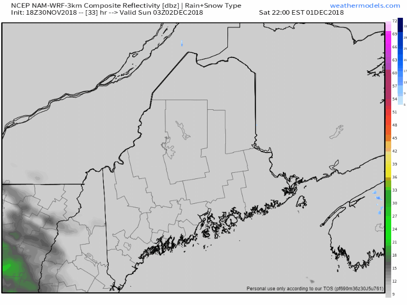
Clouds will be on the increase over western and southern areas Saturday afternoon ahead of a warm front that will enter the state on Sunday. Guidance indicates potential for a coastal low formation in the Gulf of Maine which may add some intrigue into how this plays out. This is likely to bring another inch or more of rain to the coastal plain and bring another round of heavy wet snow, freezing rain and sleet over the interior.
Picture
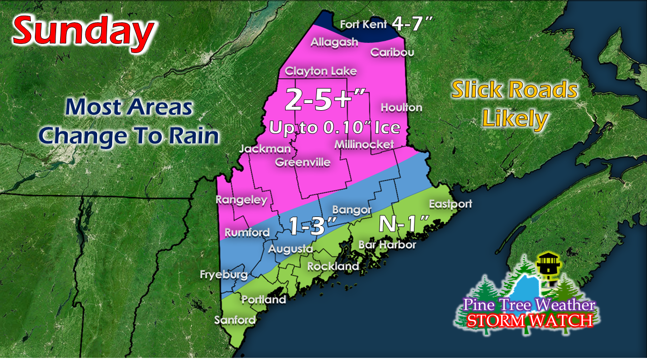
As is appears for now, this won't be a big ice event for the interior. Between the freezing rain and sleet before the switch to rain, that will keep snow totals down with the exception of the far north where mostly snow will fall. 

Regional outlook through Wednesday

Picture
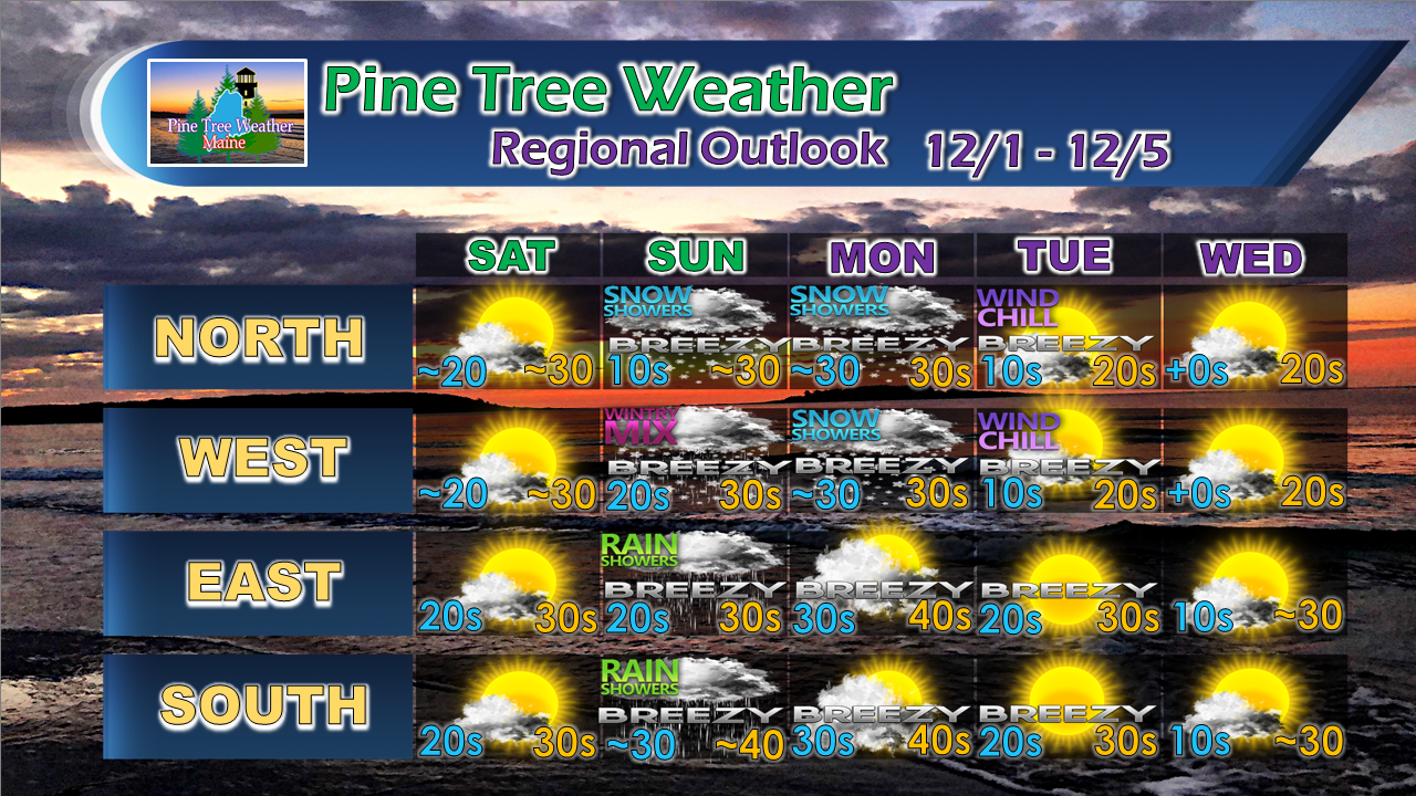
We'll get a bit of a break from the storms as it appears for now. Long range outlook shows a chance for snow showers from a clipper system roughly Friday, and a potential ocean storm late next weekend. Confidence is low on both of those ideas, but check back as the weekend unfolds.

NOTE: Due to a family commitment, I will not be updating the discussion page on Saturday. Please check the Pine Tree Weather Facebook page Sunday morning for an update. Stay in touch with the forecast guidance from the National Weather Service for the latest information. 

​For the latest official forecasts, bulletins and advisories, please check in with the National Weather Service in Gray for western and southern areas, or Caribou for northern and eastern parts of Maine.

Donations are still needed! 

Picture
​Please consider making a donation to keep Pine Tree Weather going through the year ahead. My data cost expense is increasing. The operation is 80% funded and needs your help to get through the winter. You can set up a monthly pledge on my Patreon page  or send me a message from the Facebook page or direct message on Twitter to get my address to mail a check.

For more information from me, please follow the Pine Tree Weather Facebook page and my Twitter feed.

Always stay weather aware, and thank you for your support! 

​- Mike
Comments

Rain is still needed in areas of Maine; another mixed bag on the way for Sunday

11/29/2018

Comments


While it has been a soggy fall,
half the state still running behind

Picture
Periodically I check to see where the state is at compared to normal for rainfall. Those of us that are dependent on ground water resources have struggled for the past few years. This hit close to home with me as it affected my family, and many of you messaged me about your problems, too.

Before the recent snow storms of late, the common question I received as I talked with people is how rainy this fall has been. That is absolutely true for most of us, as the greens and blues on the chart above indicate. Outside of areas along the Quebec border, most areas are running at a surplus. 
Picture
It's a different story looking back over the past year. Areas in the browns and reds are below normal, and the pinks indicate well below normal. It's not a coincidence that it is people from the browns, reds and pinks messaged me quite often in the past year inquiring about rain potential and ground water issues. Those who have followed my weather musings for a number of years now know that I have been tracking this deficit for most of that time.  Those that do read closely know this stealth drought has gone on much longer than this. 
Picture
This is the past three years looking at rainfall departure. It has improved over New England, but there is still quite a bit of a deficit over much of the six-state region. Looking at all the facts, it would be wise for folks dependent on ground water to still think conservation as we head into winter. The region was in a deep hole with the water table, and there is still a ways to go before green, blues and purples will dominate the map. 

Sunday repeats itself

Picture
While not exactly the same wash, rinse and repeat of last Sunday, it will have some similarities as far as timing goes. I know there are several of you who get my input on whether or not church services are to take place in your area. This going to be another one of those cases where it will be wait and see. The timing of this isn't good given the fact it appears to start over western areas overnight Saturday and will likely have impacts for the interior Sunday morning.
Picture
This is my idea of how I see this unfolding for now, subject to change.  Important to note that all areas may see some flakes to start off. For the coast, it does not appear to last long. Interior areas in pink are likely to see snow, changing to freezing rain and then perhaps all rain Sunday afternoon. Far northern areas appear to see mostly snow before a period of icing and a change to rain. Only the far north may escape this with little icing. 

A rough idea on snowfall appears to be in the 3-6" range before the changeover. Freezing rain is always a bit of a crap-shoot since all atmospheric dynamics have to be perfect for ice accretion to occur. One model idea has roughly 0.25"-0.40" as a possibility. That may be on the high end, but only time will tell. It's better to bet on accretion occurring than amount, and that threat is there. 

Stay tuned.  

Regional outlook through Tuesday

Picture
​For the latest official forecasts, bulletins and advisories, please check in with the National Weather Service in Gray for western and southern areas, or Caribou for northern and eastern parts of Maine.

​Your support is valued, needed and appreciated! 

​Please consider making a donation to keep Pine Tree Weather going through the year ahead. My data cost expense is increasing. The operation is 80% funded and needs your help to get through the winter. You can set up a monthly pledge on my Patreon page  or send me a message from the Facebook page or direct message on Twitter to get my address to mail a check.

For more information from me, please follow the Pine Tree Weather Facebook page and my Twitter feed.

Always stay weather aware, and thank you for your support! 

​- Mike
Comments

Snow ends for the north country Thursday morning

11/28/2018

Comments


Ski country is loaded up

Picture
Late Wednesday afternoon Sugarloaf announced they had reached the 30" mark for the storm which began on Monday afternoon. They could end up with 3 feet by the time it ends Thursday morning. I am hearing folks up that way have lost power due to the volume of snow dragging down trees and power lines in the Eustis area. The snow machine will shut down soon, and hopefully those in the dark will get power back soon. The wind is going to pick up on Thursday, with gusts 15-25+ mph, which may cause blowing and drifting of snow, as well as hinder power restoration. 
Picture
National Weather Service estimates on snow still to come from 4 PM Wednesday through tomorrow morning indicates higher elevations with another 3-6" to come. I am going to eat a bit of crow on this one. I seriously underestimated this one in the higher elevations of western mountains by a foot and a half. Incredible accumulations. And this is only November.

Looking ahead to the weekend and next week

Picture
Sunday will be the next system on the way which may start off as ice in the interior but appears for now to change to rain as a warm front kicks through, followed by snow showers from a trailing cold front on Monday. This isn't a big precipitation producer as is appears for now. We'll keep track and see if that idea stays the same, and whether or not cold air damming gets the last laugh on precipitation type for the foothills and mountains as the event gets closer.
Picture
There are two signals to watch as we head into next week. First comes around the Tuesday / Wednesday time frame. With the trailing front dragging cold air into the state Monday, that sets the table for a snow event for at least interior areas. Outside of that, there isn't a whole lot of answers to many questions at this point.
Picture
I usually do not like to put the cart this far ahead of the horse but since this idea fits the pattern we are heading into, I will pass along for future reference that the region may be dealing with another storm the second weekend in December. A lot of time for this to change, but something to keep in the back of your minds as we head into next week. 

Outlook through Monday

Picture
​For the latest official forecasts, bulletins and advisories, please check in with the National Weather Service in Gray for western and southern areas, or Caribou for northern and eastern parts of Maine.

Your support is valued and appreciated! 

​Please consider making a donation to keep Pine Tree Weather going through the year ahead. My data cost expense is increasing. The operation is 80% funded and needs your help to get through the winter. You can set up a monthly pledge on my Patreon page  or send me a message from the Facebook page or direct message on Twitter to get my address to mail a check.

For more information from me, please follow the Pine Tree Weather Facebook page and my Twitter feed.

Always stay weather aware, and thank you for your support! 

​- Mike
Comments

Snow continues for the north country through Wednesday

11/27/2018

Comments


Snowvember Rolls On

Picture
An upper level low will remain parked over the region through Wednesday before moving southeast of the state. The result will be continued snow accumulation in the mountains and north and risk of a shower over southern and eastern areas through Wednesday night. 
Picture
Model generated idea of additional snow to come shows potential for upwards of a foot or more. As the surface low spins itself out, temperatures will get cooler and allow for more fluff factor. Expect continued tricky travel in the north and mountains through Wednesday.  

Regional outlook through Sunday

Picture
Snow showers are likely to continue around the higher elevations Thursday morning and then dissipate towards the afternoon. The next system of concern approaches Saturday evening into Sunday morning which may bring another icing period for interior areas. 

Stay tuned.  

​​For the latest official forecasts, bulletins and advisories, please check in with the National Weather Service in Gray for western and southern areas, or Caribou for northern and eastern parts of Maine.

Your support is valued and appreciated! 

Please consider making a donation to keep Pine Tree Weather going through the year ahead. My data cost expense is increasing. The operation is 80% funded and needs your help to get through the winter. You can set up a monthly pledge on my Patreon page  or send me a message from the Facebook page or direct message on Twitter to get my address to mail a check.

For more information from me, please follow the Pine Tree Weather Facebook page and my Twitter feed.

Always stay weather aware, and thank you for your support! 

​- Mike
Comments

Significant winter storm to impact interior areas, gusty wind for the coast

11/26/2018

Comments


Winter Storm Warning posted for the interior

Picture
A quick update to Sunday's post on a few minor details. Timing of the storm remains on course with conditions deteriorating Monday evening over western areas and continuing overnight into eastern and northern areas. This is mainly a rain event for the shorelines, although a few flakes may mix in. The main slug of precipitation tapers Tuesday afternoon over southern and eastern areas, but snow showers will persist over western and northern areas through Wednesday, and for the mountains into early Thursday.
Picture
Wind is going to be the main concern for the coast as the storm approaches the region Monday night into Tuesday. Areas west of Penobscot Bay should see the wind begin to diminish by noon Tuesday, east by mid to late Tuesday afternoon. 
Picture
Snow map revised to show full duration totals with a some minor tweaks. I am still on board with no accumulation for the shoreline towns and cities, but the gradient levels will increase sharply over the interior.
Picture
All in all a healthy snow event for the north country, which is great news for winter weather enthusiasts.

For the latest official forecasts, bulletins and advisories, please check in with the National Weather Service in Gray for western and southern areas, or Caribou for northern and eastern parts of Maine.

​Your support is valued and appreciated!

Picture
​Every Saturday morning I get caught up on the bookkeeping to see where I am at. I am about 80% covered for year as it stands right now, which is amazing. You folks have stepped up, which really means a great deal to me. I've known that I have been working on something special for quite awhile now. The towns listed above have at least one donor. Some have two or three. The support from out of state is the real eye catcher. I get overwhelmed when I read the notes that are mailed with checks to my home. I am truly honored and blessed by your faith and belief in me. I love doing this for you folks. So long as I am funded, I will keep doing it.

The final 20% of fundraising is always the most difficult. If you have not as of yet, I ask that you please consider it during this season of giving. You can message me through the Pine Tree Weather Facebook page or tweet me so I can give you my mailing address. You can also set up for a monthly donation on my Patreon page if that works for you.

For the latest official forecasts, bulletins and advisories, please check in with the National Weather Service in Gray for western and southern areas, or Caribou for northern and eastern parts of Maine.

Always stay weather aware, and thank you for your support... it is truly an honor. 

​- Mike
Comments
<<Previous
    Picture

    Mike Haggett
    Kennebunk, ME

    Eight year forecaster.
    A 50 year Mainer.
    Penn State Weather
    ​Forecast Certification '21.
    ​Integrity first.
    Matthew 19:26.
    ​

    DONATE
    Picture

    Archives

    December 2019
    November 2019
    October 2019
    September 2019
    August 2019
    July 2019
    June 2019
    May 2019
    April 2019
    March 2019
    February 2019
    January 2019
    December 2018
    November 2018
    October 2018
    September 2018
    August 2018
    July 2018
    June 2018
    May 2018
    April 2018
    March 2018
    February 2018
    January 2018
    December 2017
    November 2017
    October 2017

    Categories

    All
    Maine Weather
    Pine Tree Weather

    RSS Feed

Proudly powered by Weebly