|
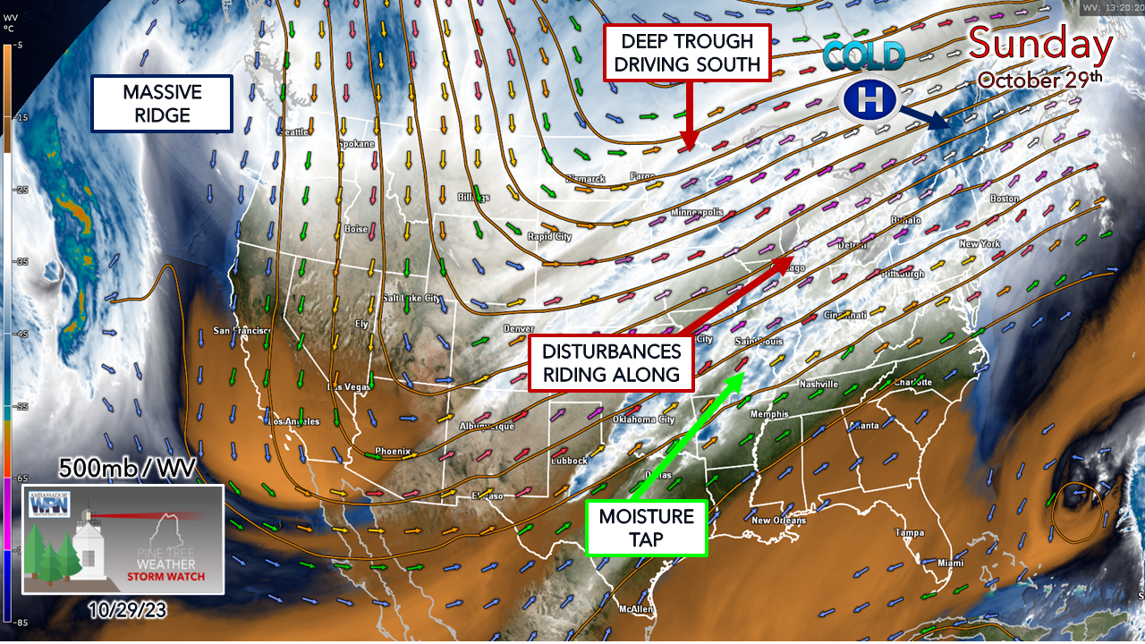
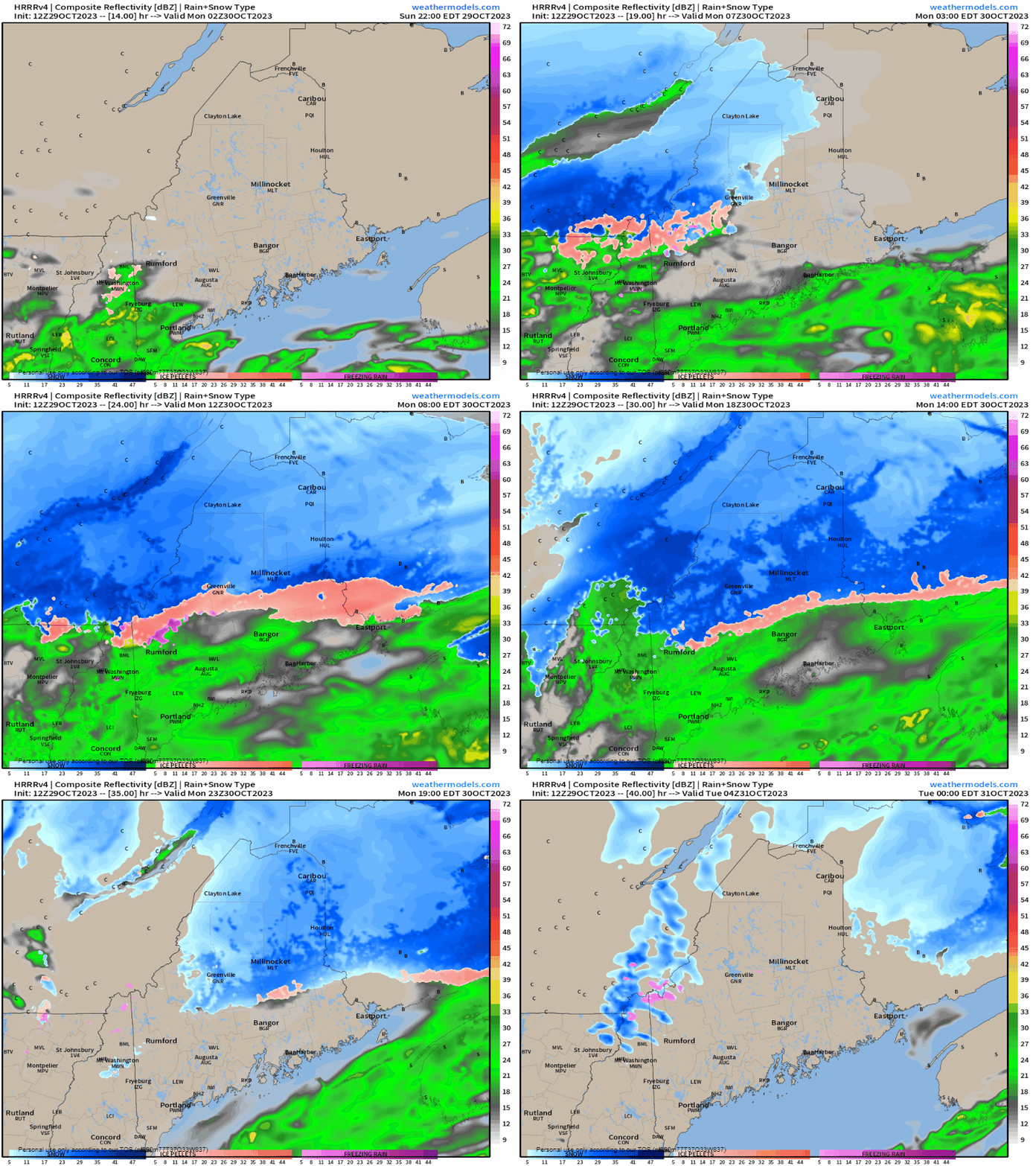
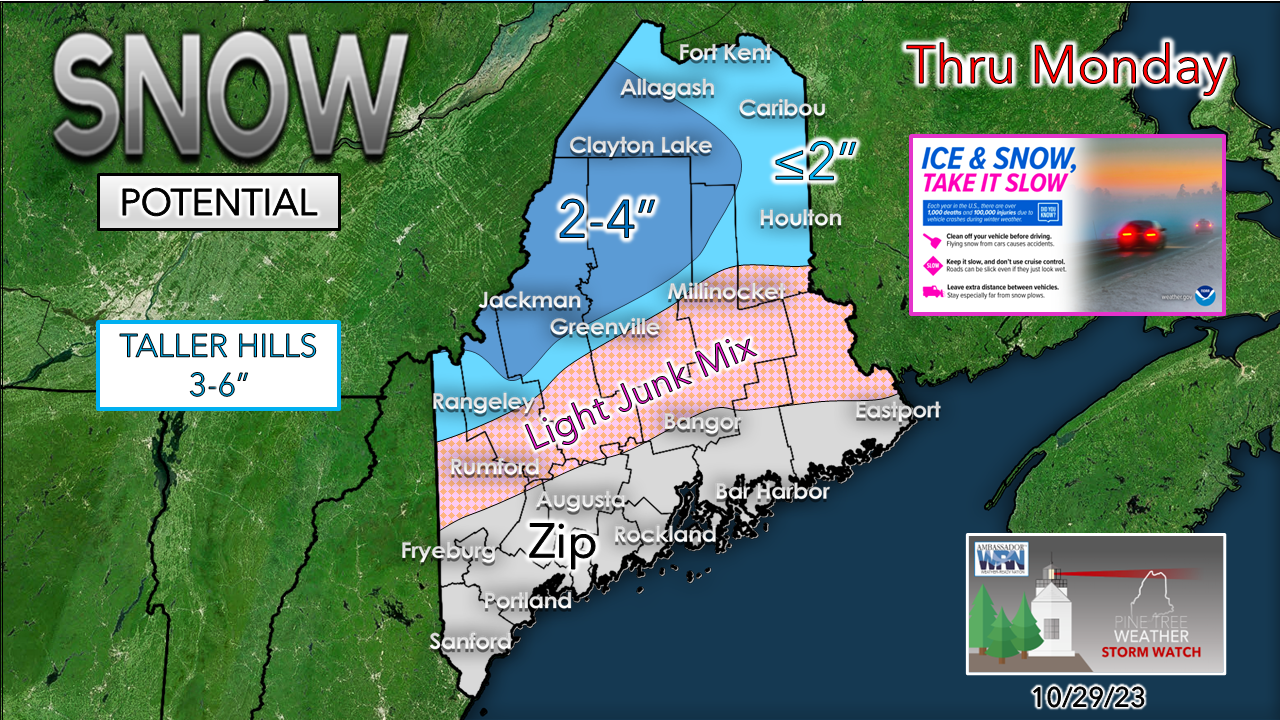
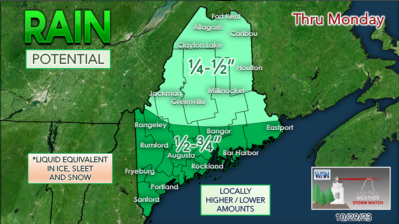
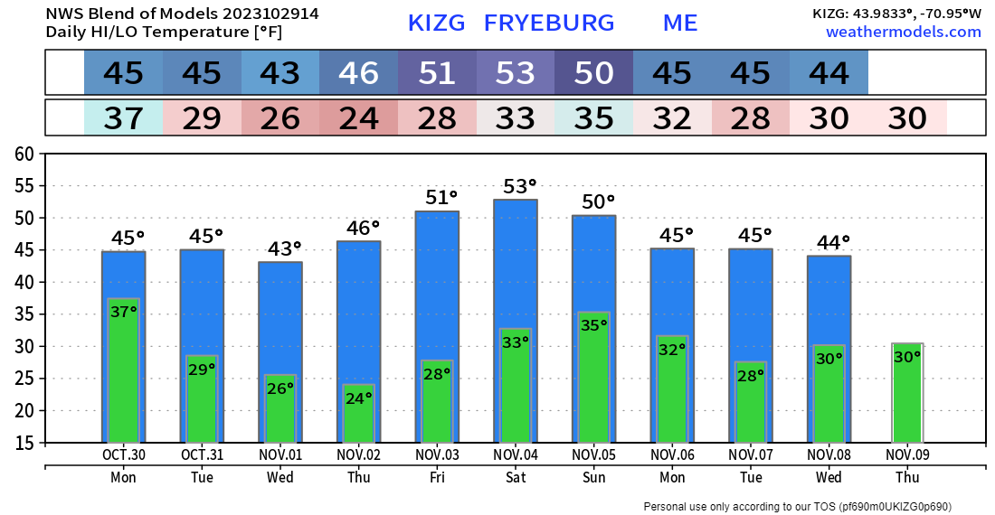
I am back in the saddle after a very short night as we arrived back in Kennebunk from Phoenix at 2 AM Sunday morning. Given all that has gone on, it's good to be back home. My thoughts and prayers continue to all my followers as we begin to heal together and move on from the massacre in Lewiston. We're all family here. We've got this, but it will take time. Having been through a lot of grieving myself in a six year stretch from 2016 to 2022, it goes its own path. Let's give each other a break, cut everyone some slack, and take a long, deep breath. Let's be sad and mad but try to contain the outrage, as anger is what fueled this. Mental illness is a tough battle. I've had to deal with my own issues around it as a recovering addict since November of 1991. Everyone's journey is unique, which makes it more difficult. In situations like this, it's worth a pause to reflect, reassess, take inventory, take action for oneself if necessary, and seek help. It's important to listen to one another, and voice concern as gracefully as possible. We walk this walk together as co-workers, friends, and family. We don't know what people have been through or what they struggle with. Let's be good to each other. The pattern looks coolWith El Niño showing its presence more as time moves along, I think this is a preview of coming attractions as we head into winter. A massive ridge over the eastern Pacific stretching into Alaska is helping to drive a strong upper low over Hudson Bay to the south. With the upper low comes the cold, which brings the risk of frozen precipitation. This isn't a great set up for a widespread shoveling exhibition anytime soon, but winter is coming. A bit of snow for the north countrySunday 10 PM to Tuesday Midnight - While Sunday features some nuisance showers and flakes around, a weak surface low moves in Sunday night and brings the goods through Monday. Interior areas need to watch out for a mix of sleet and freezing rain, but it may not amount to a whole lot. The ground is warm right now. Anything frozen or will freeze on contact may stick to the tall mountains, trees, and higher elevation roads. The sun is still strong which will keep snow accumulations down during the day. There could be a few slick spots, but nothing crazy here. A winter weather advisory is posted for the north and western mountains. Mount Katahdin and the Whites in New Hampshire will be a pretty view when all is said and done come Tuesday morning. In typical fashion to the season, there has to be some junk that comes out of this, so be aware of that over the interior closer to the mountains. Shoveling is optional as temperatures warm toward the middle part of the week, and outside of the higher peaks, whatever comes is likely to be gone by Thursday, if not before. Given the time of year. bust potential on frozen accumulations are high. This may overperform a bit for the north, but it is a tough call. Southern areas have the best chance for higher rainfall or liquid equivalent out of this. No concerns for flooding. It's just a garden variety light precipitation event. There is not a whole lot of wind here, but the mountains and north will notice a chilly northwest breeze kick up Monday night through Tuesday morning. with wind chills in the single digits and teens, with the coastal plain in the 20s to start the day. Allspeed's big ski swap event is coming SaturdayOur ski swap starts at 10am on Saturday, November 4th! We recommend getting here early to get a good spot in line so you can have a first look at the selection. The world famous Allspeed Ski Swap is BACK! Join us for our annual ski swap, it's a great way to buy and sell used gear! Our ski swap will work exactly the same as our bike swap, you bring in ski gear and if it sells you have the choice between 100% store credit or a check (we take a small commission if you choose to get a check). For more details, simply click on the image to direct you to the website. Temperature & outlook through the weekFor you folks growing, the season is over. You'll be lugging the mums in nightly if you are doing that. There is the strong hint of a coastal storm midweek that may brush the coast with some rain showers. Halloween looks good those activities, but a bit chilly with feels like temps in the 20s north and mountains with 30s for the coastal plain around dark. The rest of the week appears dry with a gradual warm up. Expect temperatures to be cooler to the north and a bit warmer for the coast in regard to this general idea for Fryeburg. Normal temperatures for the north range from 47° for a high and 32° for a low, and for the south, 54° and 37°. We'll be on the cool side to start November. Winter SKYWARN training sessions upcomingThe cost and training are FREE. You do not have to be meteorologically savvy to become a trained spotter. All that is needed is a causal interest in weather and a desire to learn more about it. The seminars are fast paced with a lot of information, along with items you may not have been aware of. This is the WINTER weather seminar. If you participated in the SPRING seminar, you should attend this one to be fully trained. If you are a current spotter and have not done one of these in the past three years, you should sign up for a refresher. For training through NWS Caribou (Aroostook, Hancock, Piscataquis, Penobscot, Northern Somerset, and Washington Counties), please click on the following dates to register: Wednesday, November 8th from 6 - 7:15 PM Wednesday, November 15th from 6 - 7:15 PM Friday, November 17th from 6 - 7:15 PM For more information, please check out the NWS Caribou SKYWARN page. For training through NWS Gray (Androscoggin, Cumberland, Franklin, Kennebec, Knox, Lincoln, Oxford, central and southern Somerset, Waldo, and York Counties along with ALL of New Hampshire), please click on the following dates to register: Monday, November 13 from 6 - 7:30 PM NWS Gray is also offering a special COASTAL FLOOD spotter training seminar Wednesday November 15th from 6 - 7:30 PM This was well attended last fall. I know a few of you missed it last year that wanted to participate, so here is your chance. For more information, please check out the NWS Gray SKYWARN page. If you want PTW to continue, I need your helpThank you for your years of following and for your financial support. It is because of your funding that this operation continues. God bless and stay strong. Be good to yourself. Stay updated, stay on alert, and stay safe! - Mike NOTE: The forecast information depicted on this platform is for general information purposes only for the public and is not designed or intended for commercial use. For those seeking pinpoint weather information for business operations, you should use a private sector source. For information about where to find commercial forecasters to assist your business, please message me and I will be happy to help you. |
Mike Haggett
|

