A day with periodic "snizzle" I am not sure who came up with the meteorological slang term "snizzle" to describe a mix of snow and freezing drizzle, but I will tip the cap to NCEP Central Operations meteorologist Margaret Curtis who used the term in her time as lead forecaster at NWS Gray as the first person I saw use it. That is what is on tap for Thursday. 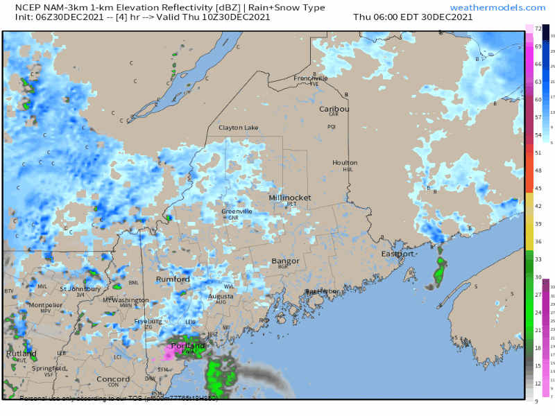 Thursday 6 AM to Friday Midnight - Periodic snow showers with accumulations of an inch or less is possible for the northern tier through the day, along with patchy fog and freezing drizzle. For the southern half of the state, more of a chance for patchy freezing drizzle with snow mixed in early, but changes to drizzle and patchy fog as the air column warms in the morning. All but eastern areas have a chance to see the sun poke through this afternoon and temporarily shut down precipitation output for a time before sunset. Accumulations are expected to be light, with an inch of snow or less expected and a light glaze of ice is possible. This will be enough to cause some slick spots either driving or on foot, so use caution while out and about for the day.
Precipitation early and late for Friday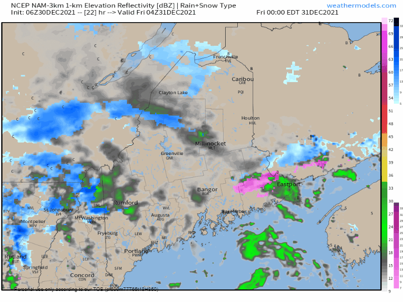 Friday Midnight to Saturday Midnight - Another weak wave passes through the region Thursday night into Friday morning which will once again generate snow showers, pockets of freezing drizzle and areas of fog. Eastern areas jipped out of sun on Thursday have the best chance to see for Friday. A few rays of sun are possible elsewhere through the stubborn low-level clouds. As a long wave trough begins to move eastward Friday, outflow head of it brings back the chances for snow showers, freezing drizzle and fog heading into New Year's Day. If you are traveling for New Year's Eve night, expect slick spots and areas of reduced visibility. New Year's weekend likely a mixed bag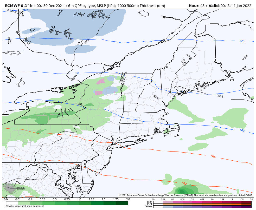 Friday 7 PM to Monday 7 AM - Models are completely onboard with precipitation to impact the region over the first weekend of 2022. What is not figured out is who gets what type of precipitation and for how long. The European idea pitched here from the Wednesday night (00z / 7 PM) run shows the mixed bag potential. I have concerns that Saturday morning features a period of icing for areas away from the shorelines as high pressure to the east may set up cold air damming situation. As moisture streams northeastward along the longwave frontal boundary, I think at this point warm air eventually wins out over southern, western and eastern areas, with the far north having the best potential to stay cold enough for icing and/or snow there. While the ideas of the passage of the frontal boundary on Sunday are fairly consistent, an area of low pressure expected to form along it and where it occurs is still to be figured out. Cold air dumps into the region on the backside, and the potential low forming along it and how quickly it intensifies will dictate wintry precipitation amounts and duration. I do not think any area is exempt from seeing snowflakes Sunday afternoon into the overnight on Monday. How much it piles up is to be determined, along with the threat for sleet. Gusty northwesterly winds are also probable Sunday night, and by Monday morning it appears that it will feel like the heart of winter. 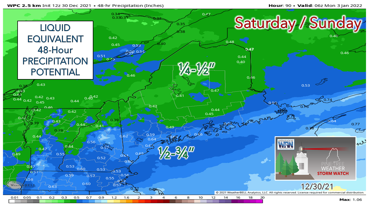 Southwestern and coastal areas have the best chance for the most liquid from the system. How much damage to the snowpack for the ski hills depends on what happens on the backside of system. If a strong low forms, whatever is lost Saturday night into early Sunday may be replaced by Monday. Stay tuned.  Temperature outlook through TuesdayThe normal high and low for Caribou is 24° and 7°. For Portland, 30° and 14°. After the warmup over the weekend, temperatures head for the basement for the north, and close to daily average south heading into next week. Temperatures fall in the north during the day Sunday as the coldest air mass of the season works into the region. 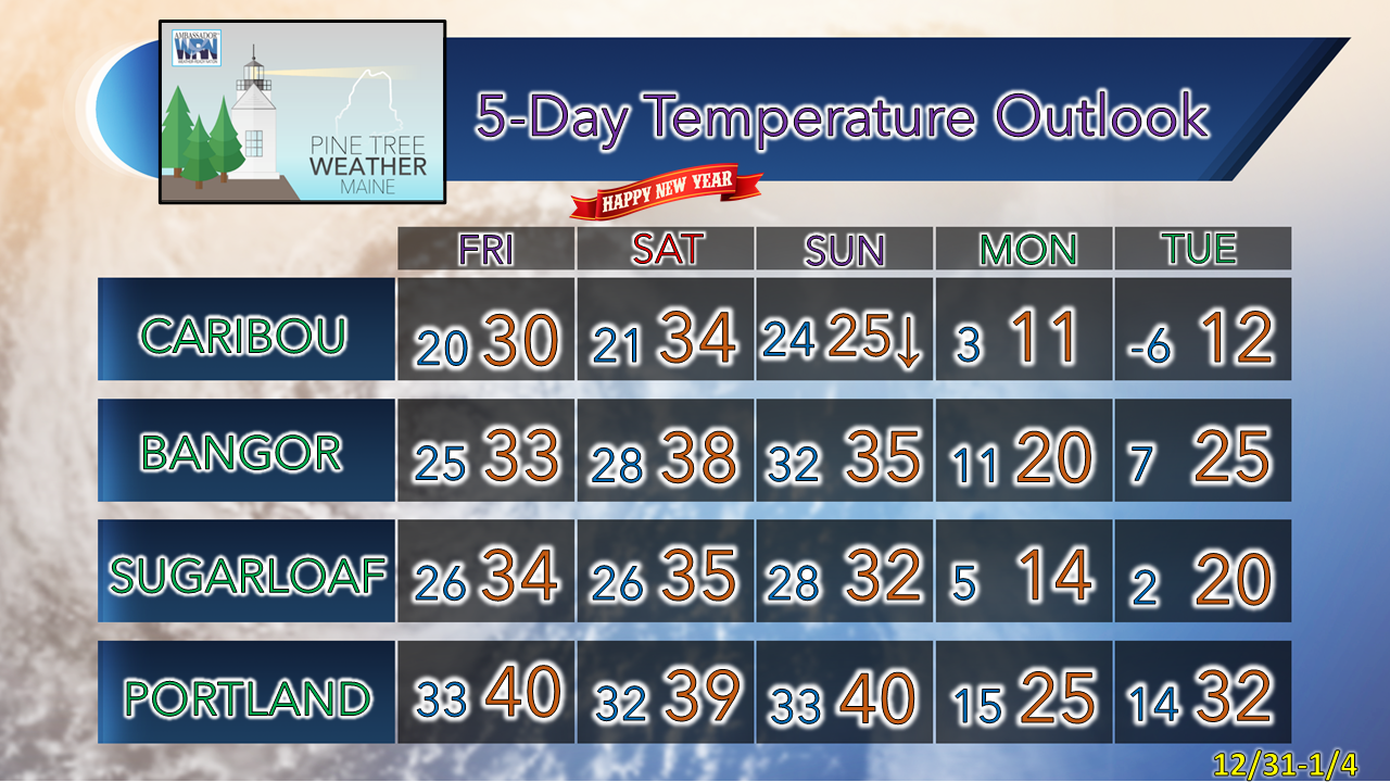 Be prepared to receive alerts and stay updated!
 For more information in between posts, please follow Pine Tree Weather on Facebook and Twitter.
Thank you for supporting this community-based weather information source which operates by reader supported financial contributions. Stay weather aware, stay on alert, and stay safe! - Mike |

Mike Haggett
|