|
First off, thanks for hanging in there with me as my family and I have dealt with the passing of my mother-in-law, and we continue to deal with the aftermath of that. Given the current structure of my life, I had to step away from here. I am slowly working my way back into updating my thoughts in some sort of frequency between here, Facebook and Twitter in the coming days. Again, I appreciate your patience and sticking with me during this rough time. Early spring blah storm to wrap up the week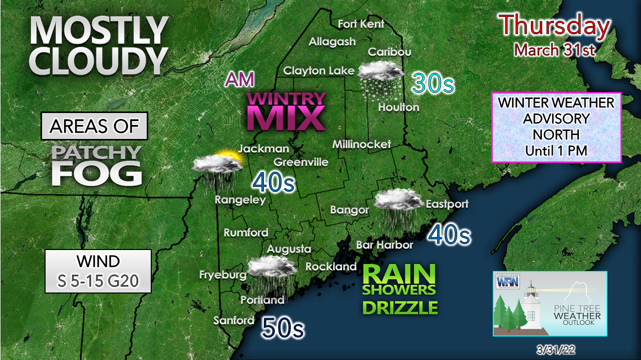 A few slick spots are possible for the interior Thursday morning. NWS Caribou has a winter weather advisory posted for the Great North Woods and The County through midday. Some areas may pick up as much as a couple inches of snow with a bit of ice possible. Precipitation associated with a warm front tapers off from southwest to northeast through the morning. The warm slot settles in and brings areas of fog into areas with snow cover, along with the shorelines with the marine layer kicking in with the southerly flow. Pockets of drizzle are possible with the fog. 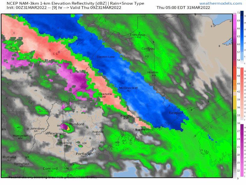 Thursday 5 AM to Friday Midnight - As the warm sector moves in, showers taper off for a time and then pick up again towards as another surge of moisture works in from the southwest. Temperatures are expected to stay above freezing through the night which in conjunction with the precipitation continues the risk for fog in spots. Western areas have the best chance to see the sun peek through Thursday afternoon. For the rest of the region, clouds appear to be the main sky feature. Cold front passes through Friday afternoon Friday Midnight to Saturday Midnight - Rain showers are expected to taper off from southwest to northeast in the wee hours of Friday morning. Outflow ahead of the approaching cold front may trigger a spot shower around mid-morning. Precipitation increases heading into Friday afternoon. With cold air working in aloft, rain transitions to frozen precipitation in the form of graupel or snow heading into Friday afternoon for the mountains and north, and Friday evening for the coastal plain. The higher elevations may pick up a coating to an inch of frozen precipitation. I can't rule out the risk of a spicy snow squall or two over western areas as cold air advection cranks as low pressure intensifies on its way to Atlantic Canada. Northwest winds pick up with the frontal passage and ushers cold air back into the region, freezing anything that is wet for all areas Friday night. This may cause some slick spots in areas. Total liquid equivalent precipitation amounts for the storm range from ¼-¾" in general, with locally higher and/or lower amounts possible by early Saturday. Outlook for the start of AprilSaturday is expected to be breezy and cool with westerly winds gusting 25-35 mph through the day, with a mainly clear sky. The wind settles down Saturday night. An approaching shortwave brings clouds back into the sky for Sunday, with the chance of a late afternoon / evening rain or snow shower over southwestern areas. Monday appears dry with a bit of a breeze behind the departing wave. Tuesday appears fair. A storm is possible later in the week. The normal high and low for Caribou for April 1st is 40° and 23°. For Portland, 48° and 31°. Temperatures in general will run a degree or two above normal on average through the beginning of the week. 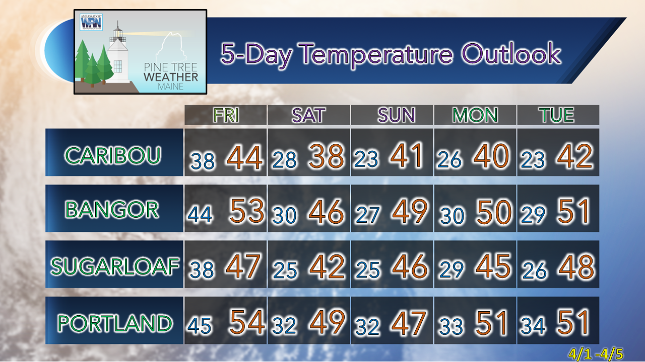 Be prepared to receive alerts and stay updated!
 For more information in between posts, please follow Pine Tree Weather on Facebook and Twitter. Thank you for supporting this community-based weather information source which operates by reader supported financial contributions. Thank you as always for your support! - Mike NOTE: The forecast information depicted on this platform is for general information purposes only for the public and is not designed or intended for commercial use. For those seeking pinpoint weather information for business operations should use a private sector source. For information about where to find commercial forecasters to assist your business, please message me and I will be happy to help you.
|

Mike Haggett
|