
|
I get a bunch of questions when something significant is about to happen in our region with the weather. This situation is no different. Thankfully there isn't a major storm in front of this so I can take time to explain what is going on here. While my education is limited, I always look for answers, and I am grateful that I have people and resources to tap into to get information, and to learn more to pass along to you. Atmosphere 101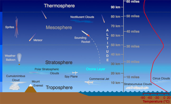 Randy Russell, University Corporation of Atmospheric Research (UCAR) This great graphic from the folks at the University Corporation of Atmospheric Research (UCAR) hits on all the important points. The troposphere and the stratosphere are the main components of our weather. Most of the business is done from the surface to 20 miles up. You can see where the troposphere usually tops out at roughly 35,000 feet. That is flight level for most commercial airliners, and the tops of most severe thunderstorms. The border of the troposphere and stratosphere can vary in height. In summer, the troposphere goes higher due to warm air. In winter, it goes lower due to cold air. Do you see that red line over on the right that shows the temperature of the atmosphere? I'll refer to that again shortly. The troposphere, the stratosphere, and the polar vortexSince there is a ton of incorrect information that gets dispersed when discussing the polar vortex, it's time to properly define it here. During my research to post this piece, I realized I was wrong in my post on Saturday, so this is how I correct my mistake. Are we going to be dealing with the polar vortex? Yes and no. Let's look at the stratosphere.  Thursday 1 PM to Sunday 8 AM - The polar vortex, properly defined, is a stratospheric level of dynamic cooling that when it is disrupted spills equatorial. For those who like to quiz me about stratospheric warming events, that is the cause for the polar vortex to be unleashed. It's a winter phenomena, sometimes it happens, sometimes it doesn't, it is virtually impossible to predict, and yes, you can get bitter cold nasty temperatures without it. This loop here shows the top level of the polar vortex in atmospheric heights. It's crawling along across Europe, fully content and compact, like one large extremely high upper-level low. Now this is properly defined and located, what is going on to cause the deep cold? 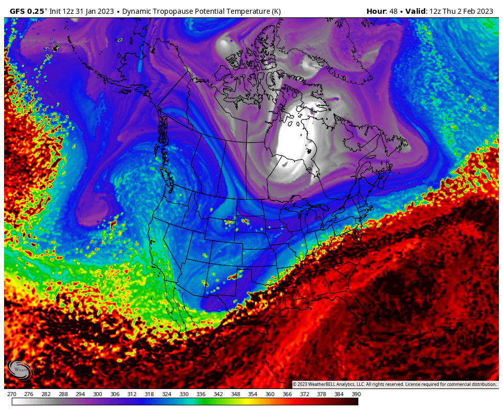 Thursday 1 PM to Sunday 7 AM - This is a loop of the dynamic tropopause potential temperature in degrees Kelvin. The tropopause is the border between the troposphere and the stratosphere. What is happening is a piece of the cold broke off of the stratospheric polar vortex and has been spinning around over Hudson Bay in the form of a cut-off upper-level low for well over a week now. What is jarring this loose is the development of a storm that will pass along the St. Lawrence River Thursday and then rapidly deepens into a major system for northeastern Quebec and Labrador on Friday. With a strong surface high developing in its wake, it hauls the deep cold to the southeast. Thankfully, the storm is motoring along and there is no blocking in its path to allow this to be a quick hit of cold and not something we have to live with for awhile. If you look closely at the loop, you can see the comma hook on it and see where the storm is predicted to haul the cold air into it just offshore of Labrador before the system slams into Greenland. This is a tropospheric polar vortex, which is a synoptic event that we see here quite often, but not to this extreme, at least recently, anyway. A synoptic event is storms like a Nor'easter, which is what the storm developing later this week will turn into. A big, bad, deep one. 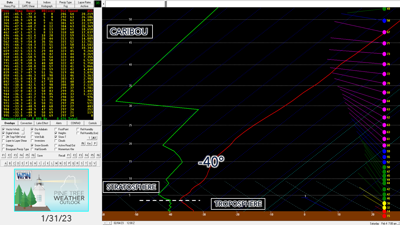 Remember the red line on the atmosphere graphic at the start? We use that red line for temperature here. You'll notice that the right hook on this Bufkit profile is predicted to occur at around 4,000 feet above sea level. With the cold as deep as it is in the troposphere, it brings the stratosphere down along with it. To put this into perspective, in summer on day with surface temperatures in the 80s, that -40° hook doesn't normally occur until around 35-40,000 feet. Tops of thunderstorms range at about that temperature. We'll get to that level at the top of a 4,500' hilltop on Saturday. Mount Washington will be in the stratosphere. The wind over 20,000' is screaming in from the west. Like I said, the storm to north is on a mission to get out of town, the wind direction signifies it, and for that, we are grateful. The timing and evolution of the coldThree different looks at this to go along with all I mentioned above. 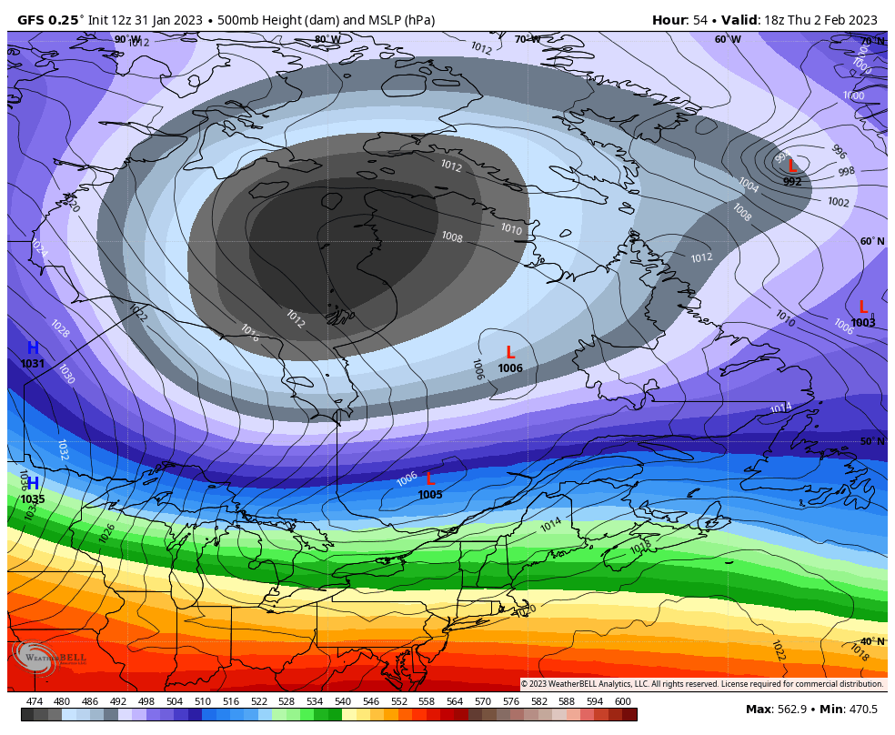 Thursday 1 PM to Sunday 7 PM - This is the look at forecast mean sea level pressure along with the atmospheric heights of the 500mb altimeter level (~20,000'). This shows the disturbance that pops up ahead of the arctic front and its intensification to the northeast towards Labrador and beyond. Anytime there is a deep low, there is a strong high nearby and in this case as the storm goes through bombogenesis, it strengthens the surface high in its wake. The atmospheric heights drop down below 474 decameters which proves the depth of the cold and how strong the upper-level low is that spins up the monster storm, that fortunately we do not have to deal with directly. You can also see where the upper-level trough pivots through the area quickly, and that is what will bring us relief on Sunday. 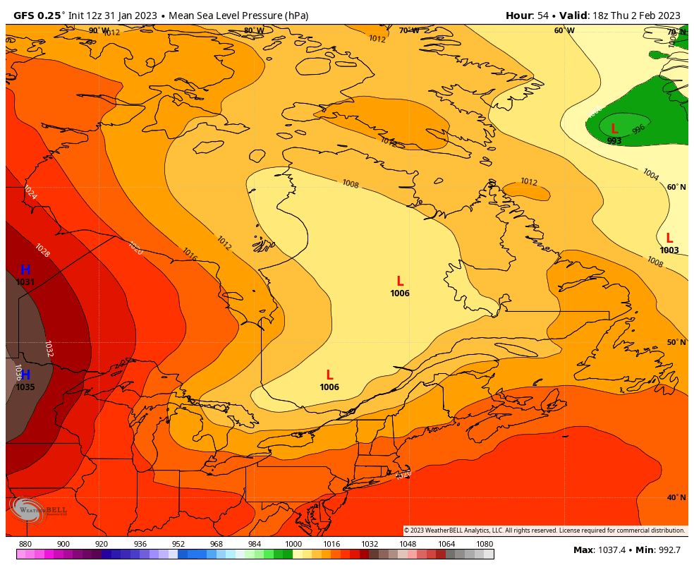 Thursday 1 PM to Sunday 7 PM - Looking at strictly mean sea level pressure here. Why the area is going to deal with bone shattering wind chill is with the storm to the northeast bombing out so severely that wind will be an issue. Wind gusts 30-40+ mph Friday into Saturday is what will bring the freezer burn. The developing area of high pressure doesn't get to the area in time to cut off the northwest wind that is delivering the cold. Once the high slides east on Sunday, the wind shifts to the southwest as an upper-level ridge moves in, which sends the deep cold out in a hurry. Sunday will be breezy, but 50-60° warmer in ambient temperature than Saturday morning. It's just insane. 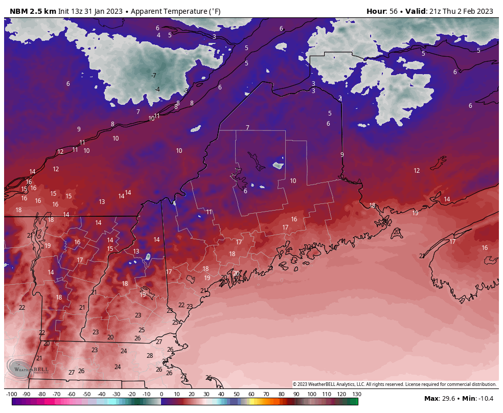 Thursday 7 PM to Monday 1 AM - This is temperature whiplash here. Will daily records be broken? Maybe, but with the wind, I am skeptical that will happen. It will definitely come close for sure in Maine, and areas to the south and west are a virtual lock to shatter records. While the wind will be horrific in temperature, it does save the area from setting monthly low records and potentially an all time cold low of -50°. That is just how brutally cold this is. Prepare nowTry to get everything you need by Thursday as temperatures drop like a missile on Friday. If you have to go anywhere on Saturday, you need to be prepared in case you break down or get to your destination and can't start your vehicle again. If you have livestock, you know the drill. If you have sensitive pipes, be careful with them. If you lose power due to down tree limbs or grid overload, make sure you are ready for that. Anything can happen here, be ready for it. 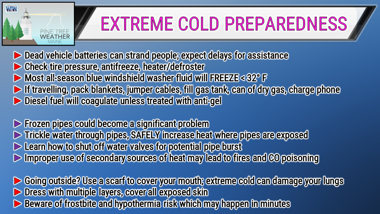  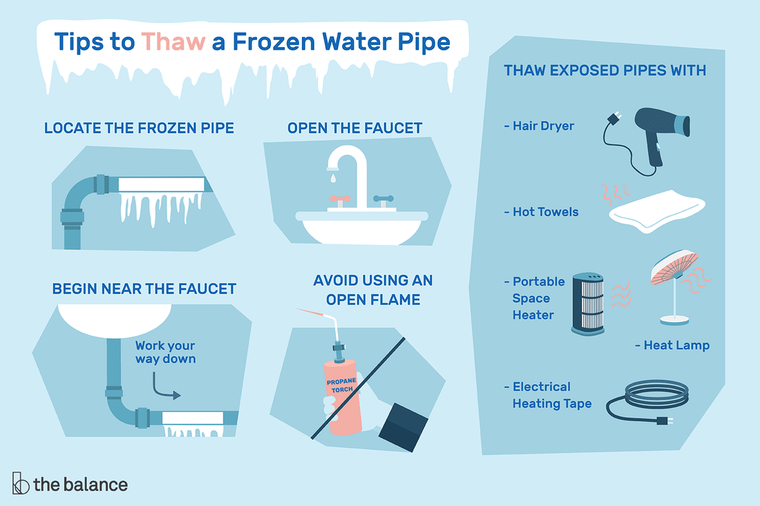  Temperature outlook through SundayFriday's temps look silly because the temperature is going to fall all day. Sunday start off cold but then rebounds quickly, but even with the wind shift to the southwest, it will still be chilly. We may get some snow on Sunday as the upper ridge moves in, and again on Monday as a clipper moves in from the northwest. More on that as it gets closer. 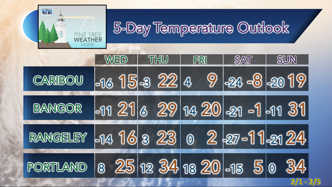 Thank you as always for your support! You may not like the weather, but I hope you like what I do! Please hit the like button on Twitter and Facebook, and share! Financial donations to fund what I do are always appreciated! Stay updated, stay on alert, and stay safe! - Mike NOTE: The forecast information depicted on this platform is for general information purposes only for the public and is not designed or intended for commercial use. For those seeking pinpoint weather information for business operations, you should use a private sector source. For information about where to find commercial forecasters to assist your business, please message me and I will be happy to help you. |

Mike Haggett
|


