Pine Tree Weather
  • DISCUSSIONS
  • DONATE
  • MAPS
  • NWS BRIEFINGS
  • SATRAD
  • MARINE
  • SNOW / ICE OUTLOOK
  • RAIN OUTLOOK
  • CPC OUTLOOK
  • Kennebunk
  • OBSERVING WEATHER
  • Who We Are
  • My Photography
  • DISCUSSIONS
  • DONATE
  • MAPS
  • NWS BRIEFINGS
  • SATRAD
  • MARINE
  • SNOW / ICE OUTLOOK
  • RAIN OUTLOOK
  • CPC OUTLOOK
  • Kennebunk
  • OBSERVING WEATHER
  • Who We Are
  • My Photography

Storm departs, another on the way for Saturday

10/27/2021

Comments

 
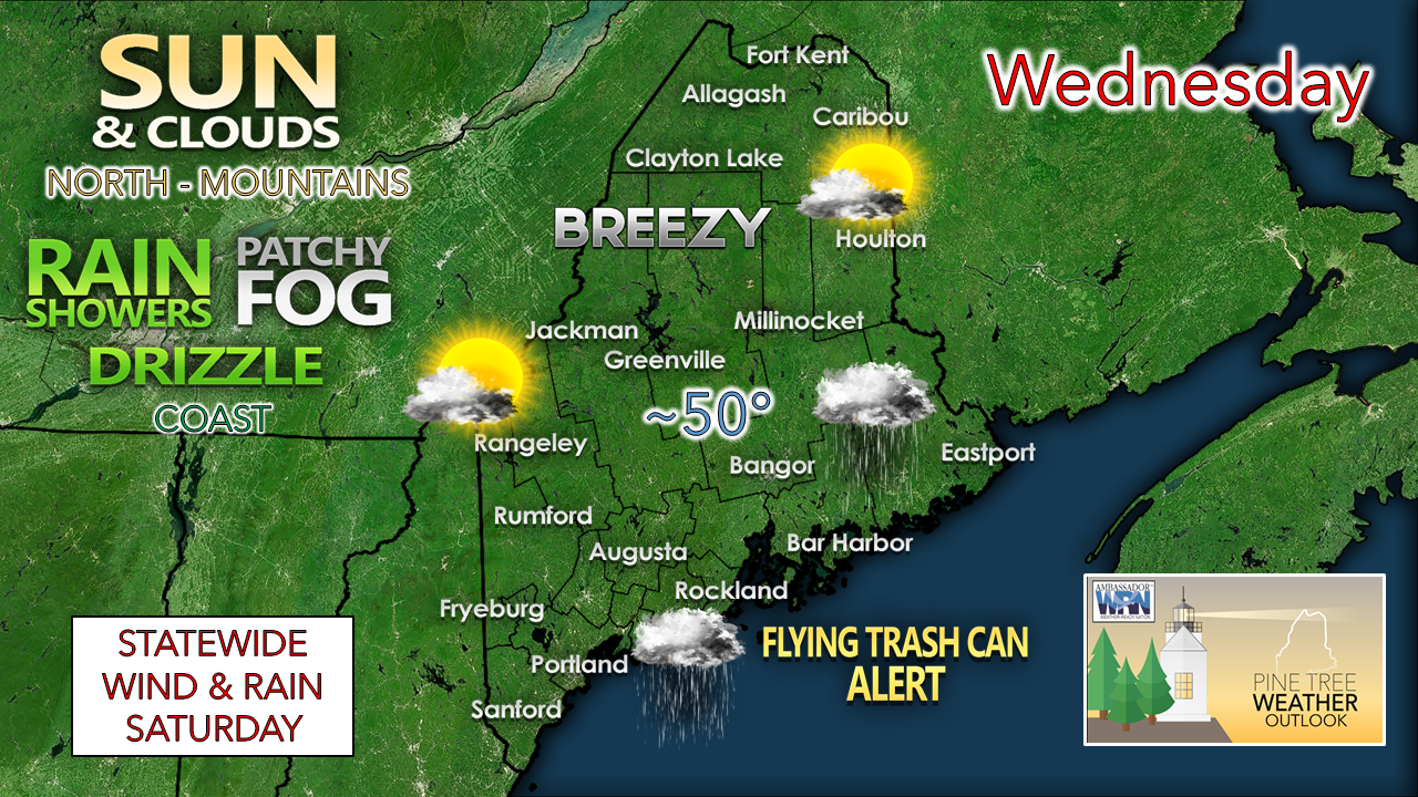
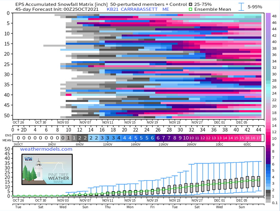
 A quick personal update here before I get into the discussion. I am going to take a break here over the weekend as my wife and I will head out of town to celebrate our 23rd wedding anniversary, a month late. We wanted to do this trip back in the end of September, but it did not work out for us to get away. Now we have the opportunity, so we will be going to Camden for a few days, and I am excited to go. 

I am close to running out of gas at this point. Sleep has been short over the past few days while tracking this current storm. I do this along with my day job in Portland. Both are demanding at times, and I am doing all I can here to take care of both ends, as well being a husband and father. 

I will provide some sort of an update on the weekend storm either here, Facebook and/or Twitter (links below) but it will be brief and to the point on Thursday.

Thank you for your financial and moral support. It means a lot to me that I have an audience that appreciates what I do which continues to grow steadily over time.  You are why I get out of bed between 2-3 AM to do this and have done so for nearly 10 years.

Sun north, rain for the coast,
​and some wind for all Wednesday

Picture
Coastal areas can look to the north and west with some shades of envy today as the mountain and north enjoy a mix of sun and clouds. There is a remote chance the sun may peek out towards sunset over southern areas as the current storm moves to the southeast, but that is the only hope for rays along the coastal plain. 
Picture
Wednesday 6 AM - Thursday Midnight: Wind will continue to be an issue. The good news is the storm has reached peak intensity and is beginning to occlude (slowly weaken). The bad news is it is stuck in a block and won't move too far until later in the day. Wind gusts in the 20-30 mph range are likely for most of the state today, shorelines and islands may see gusts to 40. I can't rule out spotty power outages through the day. It appears to be Thursday afternoon before wind dials down. 
Picture
Wednesday 6 AM - Thursday Midnight: Areas of showers, drizzle and fog appear to continue through the day for the coastal plain. As the storm drifts to the southwest, rainfall tapers down somewhat, but as the storm moves eastward in the afternoon, MidCoast and DownEast areas may see precipitation increase again as the storm departs Wednesday evening. 

Picture

Outlook through the weekend

Picture
A look at the big picture shows the players in our weather through the upcoming weekend. As the nor' easter departs, high pressure pays a visit for Thursday and Friday. A warm front with a tropical hose works into the region for Saturday and Saturday night.
Picture
Wednesday 2 AM - Sunday 8 PM: The storm over the Midwest forms along a frontal boundary and rapidly intensifies Wednesday night into Thursday morning. While the parent low weakens as it moves east, there appears to be plenty of ample energy taping into moisture from the tropics that will bring another windswept soaker to the northeast Friday into Saturday. Upper-level divergence from the jet stream will help amplify the storm, which with tropical influence brings a concern for heavy rain. 
Picture
The storm appears to be a quick mover, but it will dump rain. Wind direction on this one is more to the south / southeast, which hauls in more moisture off the water. Eastern facing mountain slopes should do well with this storm and help take an edge off the drought going on there. With the recent rain over the coastal plain, time will tell about a flood threat. With the rapid fall of rain, localized flash flooding and potential urban street flooding appear to be a possibility.

The storm departs on Sunday. Mountain showers are possible in its wake and appears to be a mix of sun and clouds with light wind for the rest of the state as it appears now. 

On a foot note, there is a threat for frost in areas Friday morning.
Picture

Winter SKYWARN Training Sessions

Picture
The National Weather Service Gray office is presenting winter SKYWARN training classes over the next few weeks. Do you have an interest to learn more about winter weather? This is your opportunity. When you watch local weather on TV and see information passed along for town reports, chances are good that it came from a trained SKYWARN weather spotter. The sessions are filled with information to accurately report winter related weather phenomena. 

These sessions are for those in western and southern Maine in the Gray office coverage area.

CLICK HERE for the direct link to register. For more information, email Donald Dumont at the address above. 

As you can see below, winter is coming. It looks good that the mountains may have snow by Thanksgiving. 
Picture

Be prepared to receive alerts and stay updated!

Picture
BE PREPARED WITH A NOAA Weather Radio.
​
​For $20-$40, it could provide vital information to you when you need it. The weather bands are standard on most public safety scanners, and newer scanner models. Weather radios can be programmed for auto alert. Click here for more information.

​​​​► ► For the latest official forecasts, bulletins, and advisories, please check in with the National Weather Service in Gray for western and southern areas, or Caribou for northern and eastern parts of Maine.
Picture

Picture
For more information in between posts, please follow Pine Tree Weather on Facebook and Twitter. 

​Thank you for supporting this community-based weather information source which operates by reader supported financial contributions. 

Stay updated, stay on alert, and stay safe!

​- Mike
Comments
<<Previous
    Picture

    Mike Haggett
    Kennebunk, ME

    Certified Weather
    Forecaster
    Penn State '21

    American Meteorological Society

    National Weather Association

    Weather-Ready Nation 
    Ambassador
    ​
    ​SKYWARN-CWOP

    Matthew 19:26


    Support
    Pine Tree Weather

    DONATE

    Picture

    Picture

    Picture

    Picture

    Picture

    Picture

    Picture

    Picture

    Picture

    Picture

    Archives

    January 2023
    December 2022
    November 2022
    October 2022
    September 2022
    August 2022
    July 2022
    June 2022
    May 2022
    April 2022
    March 2022
    February 2022
    January 2022
    December 2021
    November 2021
    October 2021
    September 2021
    August 2021
    July 2021
    June 2021
    May 2021
    April 2021
    March 2021
    February 2021
    January 2021
    December 2020
    November 2020
    October 2020
    September 2020
    August 2020
    July 2020
    June 2020
    May 2020
    April 2020
    March 2020
    February 2020
    January 2020
    December 2019
    November 2019
    October 2019
    September 2019
    August 2019
    July 2019
    June 2019
    May 2019
    April 2019
    March 2019
    February 2019
    January 2019
    December 2018
    November 2018
    October 2018
    September 2018
    August 2018
    July 2018
    June 2018
    May 2018
    April 2018
    March 2018
    February 2018
    January 2018
    December 2017
    November 2017
    October 2017

    RSS Feed

Proudly powered by Weebly