Winter Storm Warnings and Winter Weather Advisories posted for New Year's Eve and New Year's Day12/31/2018 Not a night to be driving around
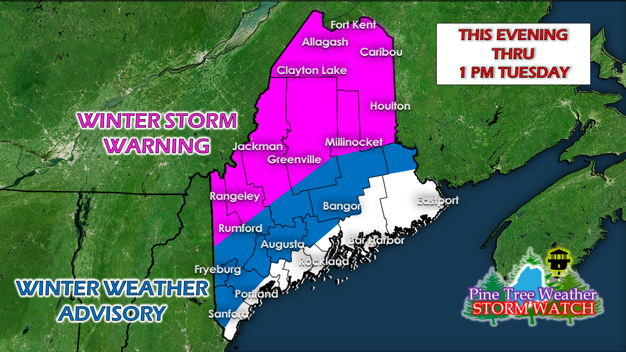
I will reiterate the point that I have said several times over the past few days, find a place to go for the night and stay there. It's New Year's Eve, aka Amateur Night, and it's going to be a stormy one. Find a hotel or inn, stay with friends, family, or mates, and don't drive tonight. Party responsibly and safe. Timing bumped ahead a bit
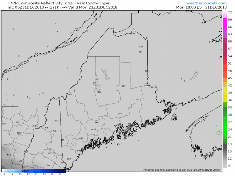
Model simulation radar starting at 6 PM Monday night shows precipitation overspreading the southwest half of the region by midnight and most of the rest of the state by 2 AM. Road conditions will deteriorate as the night progresses. Travel conditions will begin to improve after sunrise over southern areas, mid-morning for western and eastern areas, and early to mid-afternoon for northern areas. Snow prediction tweaked a hair
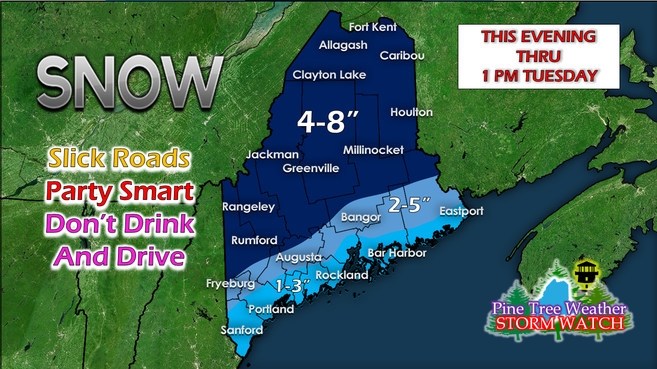
I've adjusted expected snowfall amounts for coastal areas as cold air may hold on a bit longer and allow for an inch or two of accumulation before the changeover to rain. While the southwest coast, the shorelines of the MidCoast and DownEast are not under any sort of storm bulletin as of 5 AM Monday, roads are likely to be greasy with the combination of snow, a brief mix and then rain through the overnight hours. Updates from me for the remainder of the day can be found on my Twitter feed. For the latest official forecasts, bulletins and advisories, please check in with the National Weather Service in Gray for western and southern areas, or Caribou for northern and eastern parts of Maine. Please Support Pine Tree Weather!I am sincerely blessed and humbled by your financial contributions, cards, and messages of encouragement. It's been an amazing journey over the past 7 years, and to see my efforts appreciated by those that follow is a wonderful reward for my work.
My request is for $1 per month / $12.00 per year through my Patreon page or by sending me a message on Facebook or Twitter to mail a check. The popular contribution has been $5 per month / $60 per year on Patreon, and the check donations average out to same amount as well. For those who have already donated, I sincerely thank you. For those who have yet to, I would sincerely appreciate your support in order to be fully funded as soon as possible. For more information from me, please follow the Pine Tree Weather Facebook page and my Twitter feed. Always stay weather aware! Onward to year number 8 in 2019! - Mike Synopsis Outlook Through The WeekFolks with New Years Eve plans are once again urged to find a safe place for the evening and stay put as driving conditions will deteriorate from southwest to northeast through the evening and into the overnight. Conditions will improve as the storm leaves the region Tuesday morning. A gusty northwest wind increases Tuesday afternoon ushering another round of arctic air for Wednesday. As we have seen over the past few weeks, another storm is on tap to affect the region as we head into next weekend. TimingNew Years Eve daytime Monday appears to be clear of any measurable precipitation. Once the sun sets, some snow flurries may pop up ahead of the system early Monday night. Shorelines may see a touch of snow to start off, but appear to change to a brief mix then to rain as the evening progresses. Interior western and southern zones will likely see accumulating snow by midnight. By the time the liquor establishments officially close, much of the state appears to see some form of accumulating precipitation occurring. By around daybreak Tuesday, precipitation appears to overspread the entire region. Cold air damming may play a factor in travel conditions in western areas, with freezing rain potential over the Lakes Region / Fryeburg area. Precipitation appears to end for southern and MidCoast areas by mid-morning Tuesday. By noon Tuesday, snow showers are likely for the ski hills. Light snow over northern areas appears to taper by mid-afternoon. Snowfall forecastThe ski hills and interior areas will pick up a fair amount of this event with 4-8" expected. Amounts drop from the foothills and central highlands to the coast. The breeze returns Monday night through WednesdayAs the storm approaches, wind speeds pick up from the southwest Monday night into early Tuesday. A cold front works through the region Tuesday morning, and the wind shifts to the northwest Tuesday afternoon into the evening. Gusts 25-35 mph are possible (30-40 mph for higher elevations), which may bring spotty power outages over interior areas. The return to work and school after the holiday break will be a bitter cold one. Be prepared to bundle up as much of the region will be dealing with below zero wind chill values to start Wednesday. The wind appears to drop during the day as high pressure settles in over the state. As the wind settles, the bite in the air will reduce as the day progresses. Outlook through FridayAfter mild temperatures Tuesday, temperature whiplash returns once again as the arctic high settles in for the middle part of the week. Another storm approaches the region later in the week. Stay tuned for updates on that. For the latest official forecasts, bulletins and advisories, please check in with the National Weather Service in Gray for western and southern areas, or Caribou for northern and eastern parts of Maine. Pine Tree Weather Appreciates Your Support!I am sincerely blessed and humbled by your financial contributions, cards, and messages of encouragement. It's been an amazing journey over the past 7 years, and to see my efforts appreciated by those that follow is a wonderful reward for my work.
My request is for $1 per month / $12.00 per year through my Patreon page or by sending me a message on Facebook or Twitter to mail a check. The popular contribution has been $5 per month / $60 per year on Patreon, and the check donations average out to same amount as well. For those who have already donated, I sincerely thank you. For those who have yet to, I would sincerely appreciate your support in order to be fully funded as soon as possible. For more information from me, please follow the Pine Tree Weather Facebook page and my Twitter feed. Always stay weather aware! Onward to year number 8 in 2019! - Mike A quick look aheadA bit tight on time here so I will focus on our next event which will have New Years Eve celebration impacts. As I stated in the previous update, if you have plans, it would be wise to reach your destination Monday evening and plan on staying there. Folks planning on skiing should plan on arriving Monday, if not before, as travel Monday night and Tuesday would not be without issues. While it is still early to iron out details, the model ideas today indicate that this is likely to be a mainly snow event for much of the interior with mix to rain scenario for the coastal plain. The storm is likely to last into Tuesday for the mountains, north, as well as eastern areas as it appears for now. This is NOT the final answer as of yet. We'll see how the cold coming in Sunday plays a role in the outcome. Stay tuned for more updates over the weekend. Outlook through WednesdayAfter the New Years storm, the region appears to be clear until next late next week. Bundle up if you are heading out on Sunday as the breeze will have a bite.
For the latest official forecasts, bulletins and advisories, please check in with the National Weather Service in Gray for western and southern areas, or Caribou for northern and eastern parts of Maine. Pine Tree Weather is now 90% funded to get through October of 2019. My anticipated current deficit now stands at $350 remaining to be raised to reach my goal. I am sincerely blessed and humbled by your financial contributions, cards, and messages of encouragement. It's been an amazing journey over the past 7 years, and to see my efforts appreciated by those that follow is a wonderful reward for my work. My request is for $1 per month / $12.00 per year through my Patreon page or by sending me a message on Facebook or Twitter to mail a check. The popular contribution has been $5 per month / $60 per year on Patreon, and the check donations average out to same amount as well. For those who have already donated, I sincerely thank you. For those who have yet to, I would sincerely appreciate your support in order to be fully funded by the end of the year. For more information from me, please follow the Pine Tree Weather Facebook page and my Twitter feed. Always stay weather aware, and thank you for your support! - Mike Synopsis OutlookA hat tip to my Twitter follower Chris Carleton for pointing out to me in recent rains that any salt / calcium on the roads has been washed away. With the snow and mixed precipitation on the way, this means the roads will be greasy for most areas Friday morning. I'll give Chris a plug here... he owns Allspeed Bike & Ski in Portland and Carrabassett Valley. He's one of the many small businesses that have followed me from the get-go when this operation started as Western Maine Weather nearly 8 years ago. If you are looking for ski or bike gear, stop by and tell him Pine Tree Weather sent you there. After we deal with this storm, we have another to watch for New Years Eve & Day time frame early next week. Winter Weather Advisory for the interiorThe areas shaded in blue are the main threat for not only snow, but for some freezing rain and perhaps a bit of sleet. What ice comes appears light in nature, and may knock snow totals down a bit. This will add to the grease threat for the roads. If your region is outside of the advisory area and away from the shoreline, expect "Body Shop Special" conditions. That is my term for slick roads that may surprise and cause accidents. Give yourself plenty of time to get to where you need to go Friday. TimingPrecipitation overspreads the region beginning the wee hours of Friday over western and southern areas, then over northern and eastern areas soon after daylight. Coastal areas that start off with snow appear to change over to rain in the morning over southern and MidCoast areas, around noon for DownEast. Snow changes over to freezing rain / sleet over interior areas around mid to late morning over western areas, and that moves northward through the afternoon. Much of the precipitation appears to have fallen over interior areas that any rain shower activity appears late and light. A cold front slides through the region on Saturday, which appears to bring snow showers for western areas through the morning and winding down in the afternoon. Expected snowfallA bit of a tweak in snow amounts with less along the shorelines and a bit more for northern areas. The ski areas could see 6" at the higher elevations by the time it ends. What ice / sleet and or rain that comes on the taller mountains shouldn't affect snow totals all that much. This will be the beginning of the repair for what was lost in the rain event before Christmas. Wind chill pours into the regionOnce the cold front slides through Saturday afternoon, a gusty northwest wind will kick up and dump bitter cold air into the region. Wind chill values are likely to dip below zero over much of the interior by Saturday night. The breeze will continue into Sunday, gradually settling as high pressure settles in. New Years Eve & Day a stormy oneAs mentioned in my previous update, anyone with New Years Eve plans would be wise to arrive by early evening and plan on staying there overnight. Driving overnight is not suggested. I am concerned that this may bring more snow than mixed precipitation to the region due to the cold air that will be in place once the storm arrives Monday afternoon. I will track and advise on this over the weekend. Outlook through New Years Day For the latest official forecasts, bulletins and advisories, please check in with the National Weather Service in Gray for western and southern areas, or Caribou for northern and eastern parts of Maine.
Pine Tree Weather is now 90% funded to get through October of 2019. My anticipated current deficit now stands at $350 remaining to be raised to reach my goal. I am sincerely blessed and humbled by your financial contributions, cards, and messages of encouragement. It's been an amazing journey over the past 7 years, and to see my efforts appreciated by those that follow is a wonderful reward for my work. My request is for $1 per month / $12.00 per year through my Patreon page or by sending me a message on Facebook or Twitter to mail a check. The popular contribution has been $5 per month / $60 per year on Patreon, and the check donations average out to same amount as well. For those who have already donated, I sincerely thank you. For those who have yet to, I would sincerely appreciate your support in order to be fully funded by the end of the year. For more information from me, please follow the Pine Tree Weather Facebook page and my Twitter feed. Always stay weather aware, and thank you for your support! - Mike What to expect through early next weekA few light snow showers are possible overnight as a weak frontal boundary moves quickly through Vermont, New Hampshire and western and southern Maine. Some areas may get a inch out of it, other areas a few flakes, or nothing. If traveling overnight, use caution in case of any snow covered roads. With the recent rain, roads have lost their salt and/or calcium chloride treatments, which could make roads slick where snow accumulates. Friday to be messy, especially over interior areasAfter high pressure brings a chilly day for the state on Thursday, low pressure advances from the southwest. Precipitation breaks out in the wee hours of Friday, which is likely to cause greasy roads for much of the state in time for the morning commute. Cold air damming appears to help interior areas stay in the snow / freezing rain for much of the event, turning to scattered rain showers by Friday night. The coastal plain may start off with brief period of snow / mix before changing to rain Friday morning around daylight for the southwest & MidCoast, mid to late morning for DownEast areas. A cold front approaches Saturday morning which appears to switch the interior areas back to snow showers, and gusty northwest wind brings cold air back in through the remainder of the weekend. Interior areas are likely to see the most snow from the event, along with a trace to a tenth of an inch of ice. Higher elevations should see mostly snow from the storm, with a light icing possible Friday afternoon into the evening. The new snow over the mountains and central regions should hold up well as any liquid precipitation appears to be light in the overnight hours, and then will change back to snow showers as the cold front sweeps through Saturday morning. Outlook through New Year's EveFolks headed for the ski hills this weekend should bundle up as temperatures drop Saturday afternoon into Sunday morning. Wind chill values will be flirting with 0° Sunday. New Years Eve appears to start off well, with clouds on the increase and precipitation breaking out over southern and western areas in the evening.
Stay tuned for updates! For the latest official forecasts, bulletins and advisories, please check in with the National Weather Service in Gray for western and southern areas, or Caribou for northern and eastern parts of Maine. Pine Tree Weather is now 90% funded to get through October of 2019. My anticipated current deficit now stands at $350 remaining to be raised to reach my goal. I am sincerely blessed and humbled by your financial contributions, cards, and messages of encouragement. It's been an amazing journey over the past 7 years, and to see my efforts appreciated by those that follow is a wonderful reward for my work. My request is for $1 per month / $12.00 per year through my Patreon page or by sending me a message on Facebook or Twitter to mail a check. The popular contribution has been $5 per month / $60 per year on Patreon, and the check donations average out to same amount as well. For those who have already donated, I sincerely thank you. For those who have yet to, I would sincerely appreciate your support in order to be fully funded by the end of the year. For more information from me, please follow the Pine Tree Weather Facebook page and my Twitter feed. Always stay weather aware, and thank you for your support! - Mike |
Mike Haggett
|
Proudly powered by Weebly