Pine Tree Weather
  • DISCUSSIONS
  • DONATE
  • MAPS
  • NWS BRIEFINGS
  • SATRAD
  • MARINE
  • SNOW / ICE OUTLOOK
  • RAIN OUTLOOK
  • CPC OUTLOOK
  • Kennebunk
  • OBSERVING WEATHER
  • Who We Are
  • My Photography
  • DISCUSSIONS
  • DONATE
  • MAPS
  • NWS BRIEFINGS
  • SATRAD
  • MARINE
  • SNOW / ICE OUTLOOK
  • RAIN OUTLOOK
  • CPC OUTLOOK
  • Kennebunk
  • OBSERVING WEATHER
  • Who We Are
  • My Photography

Heavy rain may cause areas of flooding Friday into Saturday

10/31/2018

Comments


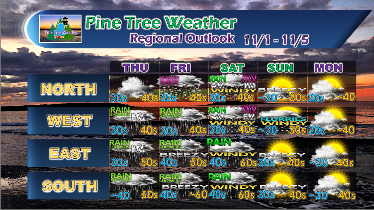
Area continues to make up for lack of rainfall

Picture
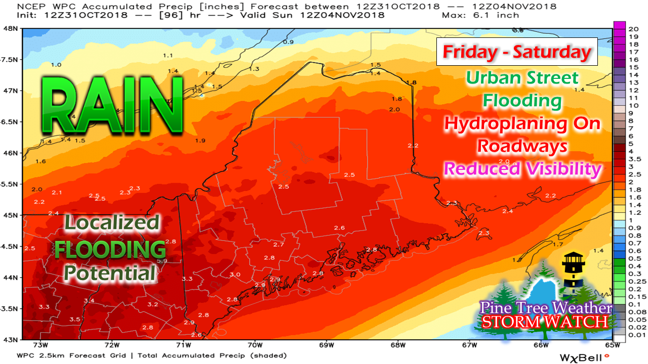
Outlook from the Weather Prediction Center for forecast rainfall through Sunday morning is pitching the idea of upwards of 3" of rainfall in western areas of the state. This is good news for those with groundwater supply concerns. After a very dry spring for much of the western foothills and coastal areas, this fall has been a wet one. This event through the first half of the weekend may get most of the drought regions back up to normal for the year. 

Main area of concern for some minor or localized flooding is over the western mountains and foothills, southern areas of the Great North Woods and the Central Highlands. Street flooding from clogged storm drains is entirely possible in any urban areas. Saturday appears to bring the heaviest rainfall, but pockets of downpours working in the region on Friday may cause driving and visibility issues as well.

Forecast stays on track

Picture
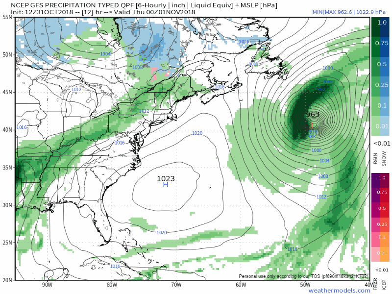
The cold front working into the area Halloween night stalls just south of Maine by Thursday morning. It returns back into the region Thursday afternoon as a warm front, with scattered showers. The Crown of the state sees a snowy mix develop early Friday that may slick the roads a bit, but eventually changes to rain by Friday night.

Model ideas indicate that some of disturbances riding along the frontal boundary could be rather juicy Friday into Saturday. Another concern is a split in temperatures from southwest to northeast, putting the mountains and north in the 40s and the coastal plain potentially in the 60s. With a decent moisture hose attached to the front stemming all the way from the Gulf of Mexico, I'd say there is a reasonable bet for some embedded thunderstorms for the region Saturday. Along with the rain comes the potential for windy conditions, with gusts 25-35 mph or higher possible. Some areas may see power outages. 

Once the front kicks out of the region Saturday night, the mountains, perhaps the foothills and the north country may see rain change to a mix of sleet and then snow as cold air gets dragged down from Quebec behind the front.  The western mountains may deal with some flurries and squalls Sunday morning as gusty northwest winds at the higher elevations create some down slope frozen precipitation. 

Winter Weather Preparedness Day 3:
​Outlooks, Advisories, Watches and Warnings

Picture
The National Weather Service offices that serve New England have declared October 29th through November 2nd, 2018 Winter Weather Preparedness Week. The National Weather Service in Caribou will feature a different educational topic each day during the preparedness week.

Topic: Winter Weather Watch, Warning, Advisory

To alert the public to potentially dangerous winter weather events or situations, the National Weather Service issues OUTLOOKS, WATCHES, WARNINGS, and ADVISORIES.

OUTLOOK - A HAZARDOUS WEATHER OUTLOOK is issued to alert the public to the potential for any hazardous weather during the next 7 days (including significant winter storms, high winds, coastal flooding, and extreme cold temperatures).

ADVISORY- Issued to alert the public that winter conditions are expected to cause a significant inconvenience and may be hazardous. If caution is exercised, these situations should not be life threatening. Products include WINTER WEATHER ADVISORY, WIND ADVISORY, and WIND CHILL ADVISORY.

WATCH - WATCHES are issued to alert the public that dangerous winter conditions are possible within the next 24 to 60 hours. Products include: WINTER STORM WATCHES, HIGH WIND WATCHES, and COASTAL FLOOD WATCHES.

WARNING - WARNINGS are issued to alert the public that dangerous winter conditions are likely to occur within the next 6 to 36 hours or are occurring. Products include WINTER STORM WARNING, ICE STORM WARNING, BLIZZARD WARNING, HIGH WIND WARNING, WIND CHILL WARNING, and COASTAL FLOOD WARNING.

These products when issued can be found on our main website page at www.weather.gov/car/ (northern and eastern Maine) or https://www.weather.gov/gyx/ (western and southern Maine) or by using other platforms such as private weather or FEMA weather alert apps www.fema.gov/mobile-app. Please revisit our page www.weather.gov/car this week for useful winter weather information to get you and your family prepared for this upcoming season. In addition follow us on Facebook https://www.facebook.com/NWSCaribou and Twitter this week https://twitter.com/nwscaribou for additional information.

Pine Tree Weather is a proud Weather Ready Nation Ambassador in coordination with the National Weather Service Caribou for the state of Maine. ​​

Outlook through Monday

Picture
After a stormy period through the first half of the weekend, Sunday and Monday appear generally dry. Another frontal boundary approaches the region Monday night, and brings with a good chance for a wet Tuesday and Wednesday. 

Please Support Pine Tree Weather

Thanks to several of you who have been so generous in sending along financial support for what I am doing here, either through the mail or posting a monthly pledge on my Patreon page. Some of the data I use in my forecasts and presented here on this website is seeing a rather sharp increase in cost that went into effect on short notice. In order for me to have the rights to share the weather charts and GIF loops with you, I need to pay more to do it. I would love to continue to deliver a good product to you, and something that I take pride in. I have put countless hours of my own time and thousands of dollars of my own cash into this over the past seven years. I want to keep this going and develop it further, but I can't do it without help from my followers. All I ask for is $1 per month/$12 per year or whatever the Good Lord lays on your heart. I would sincerely appreciate it. ​Check out the donate page on how to contribute.

Stay Updated! 

For the latest official forecasts, bulletins and advisories, please check in with the National Weather Service in Gray for western and southern areas, or Caribou for northern and eastern parts of Maine.

For more information from me, please follow the Pine Tree Weather Facebook page and my Twitter feed.

Always stay weather aware, and thank you for your support! 

​- Mike
Comments
<<Previous
    Picture

    Mike Haggett
    Kennebunk, ME

    Certified Weather
    Forecaster
    Penn State '21

    American Meteorological Society

    National Weather Association

    Weather-Ready Nation 
    Ambassador
    ​
    ​SKYWARN-CWOP

    Matthew 19:26


    Support
    Pine Tree Weather

    DONATE

    Picture

    Picture

    Picture

    Picture

    Picture

    Picture

    Picture

    Picture

    Picture

    Picture

    Archives

    January 2023
    December 2022
    November 2022
    October 2022
    September 2022
    August 2022
    July 2022
    June 2022
    May 2022
    April 2022
    March 2022
    February 2022
    January 2022
    December 2021
    November 2021
    October 2021
    September 2021
    August 2021
    July 2021
    June 2021
    May 2021
    April 2021
    March 2021
    February 2021
    January 2021
    December 2020
    November 2020
    October 2020
    September 2020
    August 2020
    July 2020
    June 2020
    May 2020
    April 2020
    March 2020
    February 2020
    January 2020
    December 2019
    November 2019
    October 2019
    September 2019
    August 2019
    July 2019
    June 2019
    May 2019
    April 2019
    March 2019
    February 2019
    January 2019
    December 2018
    November 2018
    October 2018
    September 2018
    August 2018
    July 2018
    June 2018
    May 2018
    April 2018
    March 2018
    February 2018
    January 2018
    December 2017
    November 2017
    October 2017

    RSS Feed

Proudly powered by Weebly