
A razor sharp cold front passes through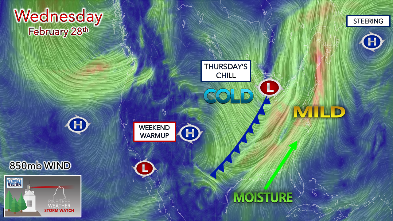 Spring is in the air, and it can be seen easily with this setup as cold and mild air is in an epic battle over the eastern half of the country. The area of low pressure and associated frontal boundary mean business. Thankfully the impacts for Maine won’t be as bad as the December 18th storm, but it will bring its own share of issues and areas of potential problems. It would do you well to stay updated on the forecast and stay on alert as Wednesday evening could get interesting around here. Wind concerns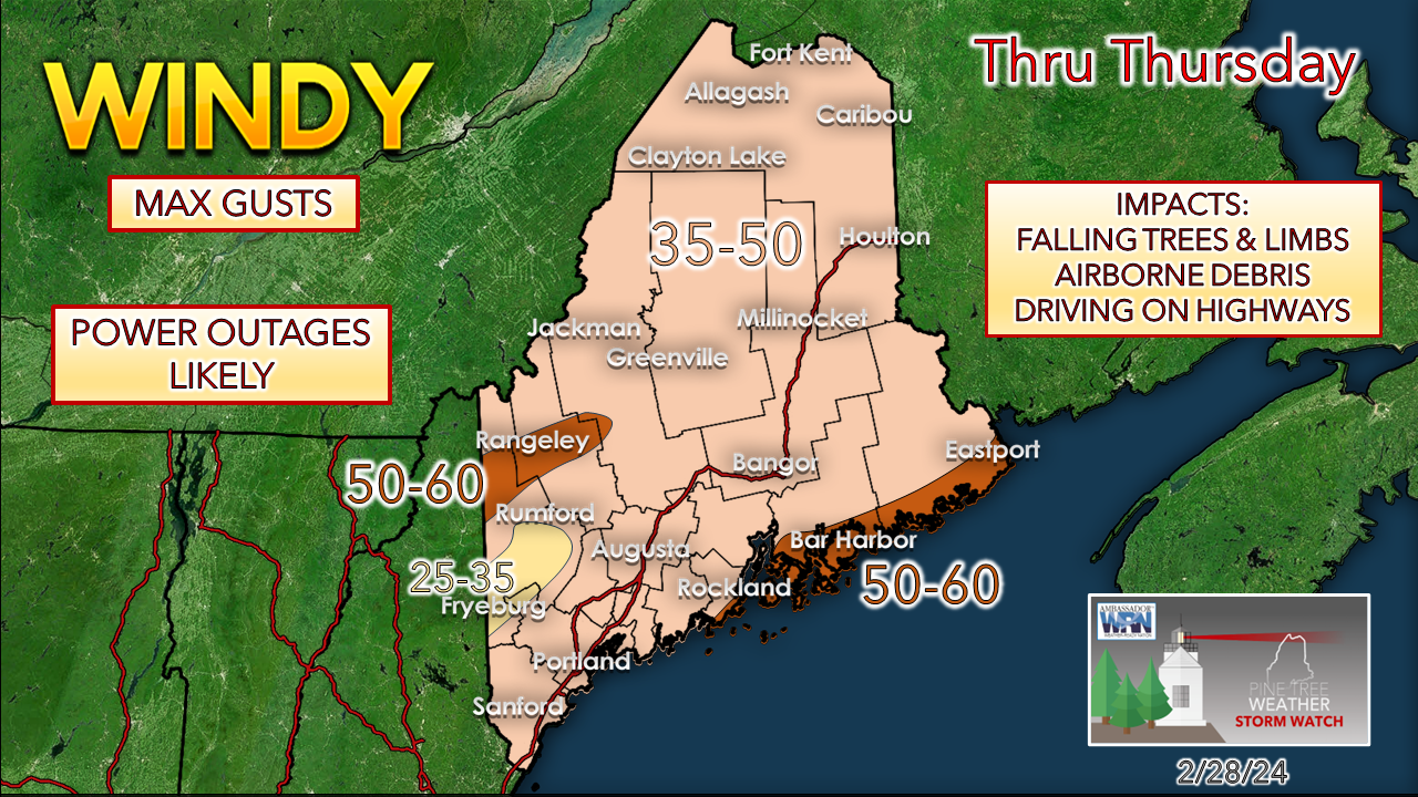 Two phases of the wind play a role here. The first is the outflow ahead of the cold front during the day. This affects the coastal areas more than elsewhere. Given the intensity of the cold front, winds are expected to be intense for 3-4 hours after the frontal passage, which is where these high-end gusts likely take place. With the secondary low’s rapid development, it will remain gusty throughout Thursday, then settle in the overnight hours into Friday morning. Spotty power outages appear likely. DownEast areas under high wind warning have the best chance for more widespread power outages. Folks traveling through Thursday should know the risk of falling trees, limbs, and debris. Flooding concerns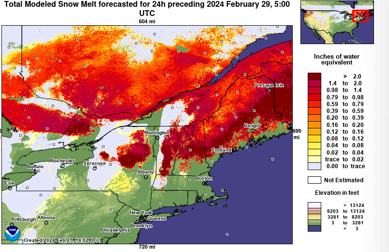 As discussed here over the past several days, what snowpack remains likely to get all but wiped out. The general idea is that 1-2” water content is locked up in the snow, with likely higher amounts in the mountains. 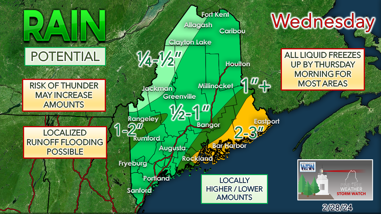 Short-term model ideas think more than 1” of rainfall is possible along the southerly-facing slopes. Runoff flood potential is very likely for the brooks, streams, and small rivers—a particular concern for the tributaries with ice, with the potential for jams. The major rivers could see some minor flooding out of this, with localized moderate levels possible, depending on how much rain falls in the mountains and how much snowmelt takes place. Expect river levels to rise Thursday into Friday before dropping over the weekend. With the ground frozen, areas of heavy rainfall from convective showers and potential thunderstorms could cause poor drainage, urban street flooding, and basements. Remember that this all freezes up by Thursday morning. While the wind will crank and help dry out quite a bit of the moisture, the rapid temperature drop with the passage of the intense cold front raises my eyebrow a bit. Some areas protected from the wind won’t dry out in time, and black ice will be a concern. SEVERE THUNDERSTORMS are possible, with a damaging wind threat as the primary concern as the cold front passes through Wednesday evening. Expect loud, ground-shaking thunder if any do develop. BACKSIDE SNOW appears to be minor with accumulation. Given the convective energy around, there could be some snarky squalls in the western mountains and north. Higher elevations may pick up a couple of inches where dynamic cooling is expected sooner, with a smattering possible elsewhere. Temperatures crash hard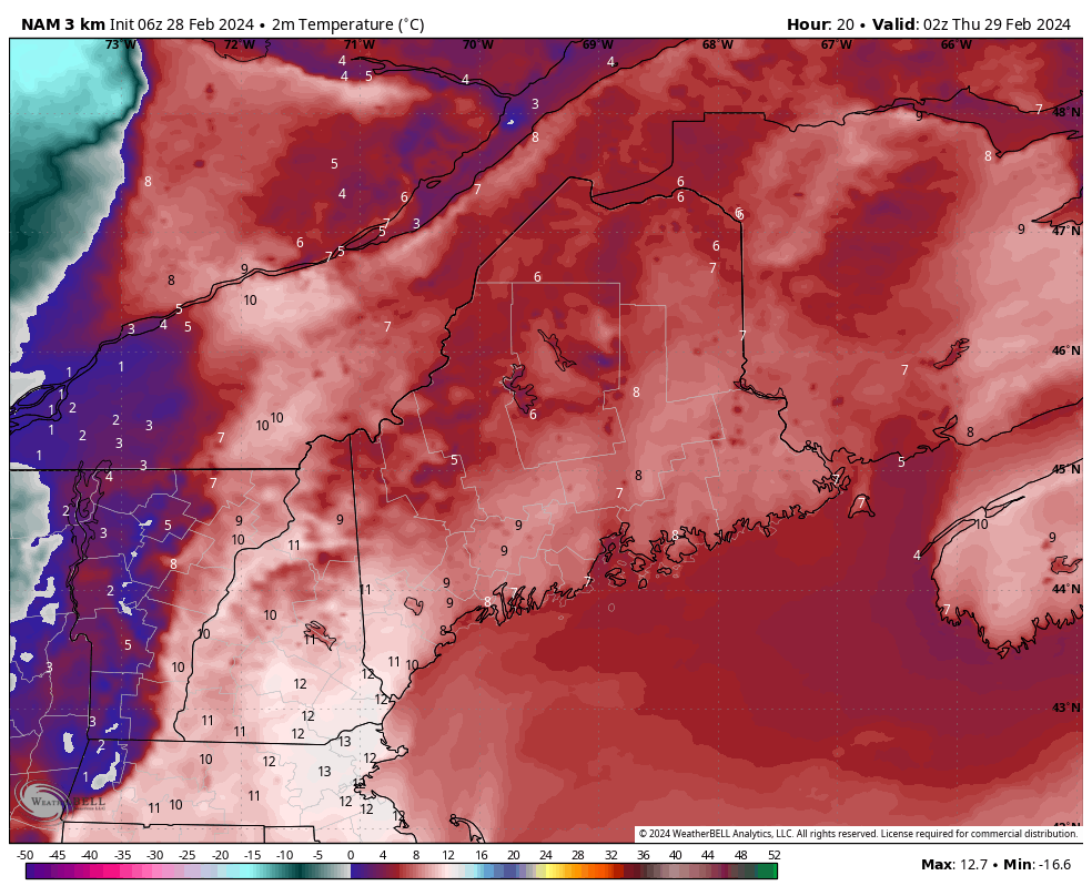 Wednesday 9 PM (02z Thursday) to 9 AM Thursday (14z)- Temperatures in degrees Celsius to indicate the rapid fall. Wind chill values by Thursday morning are expected to be in the teens below zero in the mountains to single digits above for the coast. It is expected to stay that way all day and into Thursday night. It remains on the chilly side through Friday morning before a southerly flow returns Friday afternoon and pumps warmer air back into the region for the weekend. Check out PTW for information 24 hours a day Thank you to Allspeed Cyclery & Snow in Portland, Downeast Aerial Photography in Rockland, Dutch Elm Golf Club in Arundel, and Sunrise Property Services in Bridgton, for partnering with Pine Tree Weather. Special thanks to all the individuals and businesses who financially contribute. I sincerely appreciate your support. Always have MULTIPLE ways to receive weather alerts. Stay updated, stay on alert, and stay safe! - Mike PRINT MEDIA: Feel free to quote and cite my work here for your stories. Please give me the professional courtesy of knowing that you are referencing my material so I can read your final product and acknowledge it on my media and link it on the PTW IN MEDIA page here on the website. Feel free to send me a message via the Facebook page or Twitter (X) to get my phone number if necessary. Thank you! NOTE: The forecast information depicted on this platform is for general information purposes only for the public and is not designed or intended for commercial use. For those seeking pinpoint weather information for business operations, you should use a private sector source. For information about where to find commercial forecasters to assist your business, please message me and I will be happy to help you. |

Mike Haggett
|


