
Another soaker for the region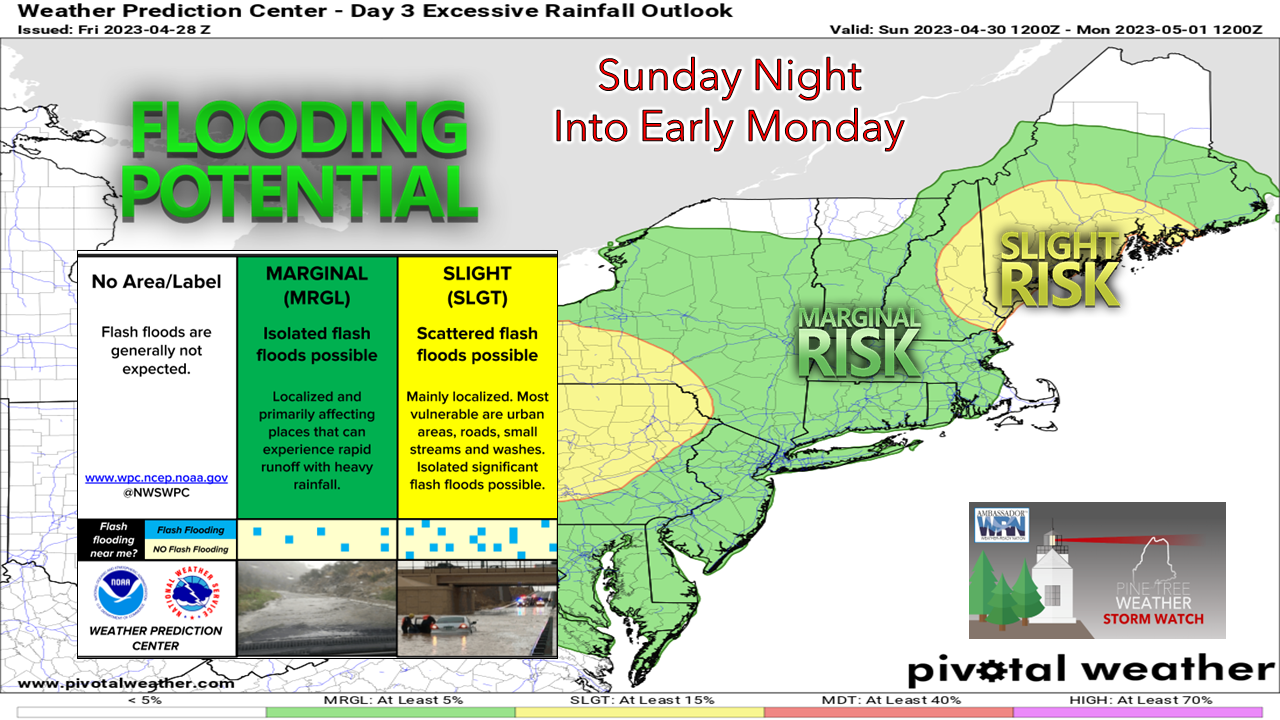 While this recent weather pattern has been unsettled and cool, the upside here is forecasters are not talking about drought and wildfires. We did have that dry stretch a couple of weeks back, but the rain deficits at that point have all turned into a surplus. For those that depend on groundwater resources for the daily needs of life, this is a welcome relief for a change. For those travelling Sunday night into Monday, this is the timeframe where the main hazards appear. For those prone to basement flooding, there is a chance you may have issues. The recent rain has saturated the ground, and with a quick hitting dumper situation that is on the way, the water that falls from the sky will be looking for a place to go. For those that travel in the mountains and areas where there is some snow around, there could be some areas of flash flooding from runoff. The headwaters of the rivers are perhaps the greater concern for flooding out of any area in this event, but any of the areas in the slight risk (yellow) region could see brooks, streams and rivers swell and tip their banks a bit. This won't be a major problem, but enough to stay on alert for. The main event rolls through Sunday night Saturday 2 PM to Monday 8 PM - It appears the region stays dry for Saturday outside of the risk of a spot sprinkle or shower over the south and west during the afternoon. Low pressure out ahead of the upper low dropping down over central Canada to the Great Lakes brings some light showers Saturday night into Sunday. As that gets swallowed up by the surface low to the south Sunday afternoon, this is where the rain and wind intensifies heading into Sunday night. The heavy rain and wind work through most of the state overnight into early Monday. As the dry slot works in as the surface low to the northwest weakens, Monday brings sun to help dry out the rainfall for the southern 2/3rds of the state, as clouds and showers continue over The County through the day. 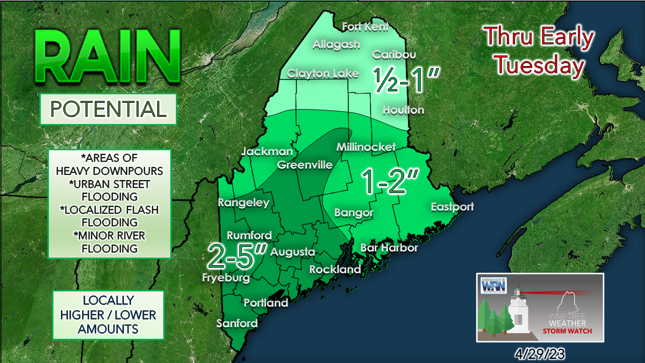 The highest rainfall totals are expected in the mountains as the southeasterly winds throw moisture up against the higher elevations. This is where the main concern for flash flooding lies. With the heavy rain and wind, there is the risk of clogged storm drains in urban areas, along with standing water on roadways. The Monday morning commute could be impacted as the rain shield progresses northeastward. 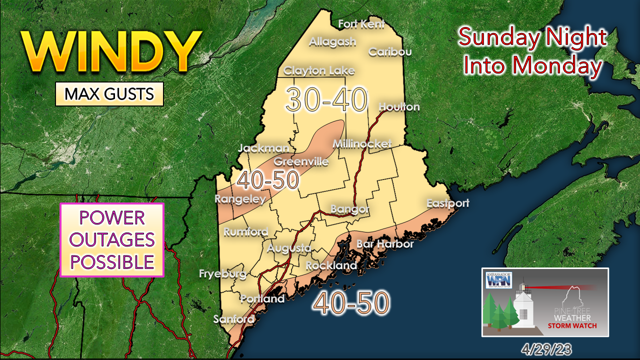 The low-level jet will be screaming between 60-80 knots, but short-term ideas indicate a capping inversion just below it which keeps the high speeds above the surface. That said, heavy rain can drag down strong gusts which brings a vertical threat in conjunction with the horizontal one from the surface low. The coast and the mountains see the strongest gusts Sunday night into the wee hours of Monday, with the wind threat diminishing soon after daylight in the north and east. Expect Monday to be a breezy day, which will assist in drying the soaked areas out. Upper-low sits and spins over the area all week For areas that are fortunate to get sun on Monday, enjoy it. This cut-off ball of atmospheric trash brings repeated waves of disturbances through the area throughout the week, which keeps the region mainly cloudy with a risk of showers from Tuesday through Saturday. Fingers crossed that we have dry, fair day by next Sunday. Spring season means atmospheric blocking season, and that is what we are dealing with. Temperatures remain generally cool compared to the season average through the week. 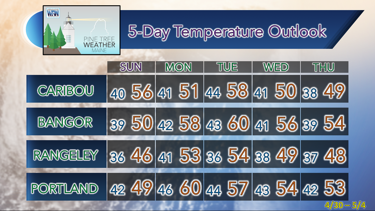 Pine Tree Weather is funded from followers like you. I would appreciate your financial support. Click here for how you can contribute. You may not like the weather, but I hope you like what I do! Please hit the like button on Twitter and Facebook, and share! Stay updated, stay on alert, and stay safe! - Mike NOTE: The forecast information depicted on this platform is for general information purposes only for the public and is not designed or intended for commercial use. For those seeking pinpoint weather information for business operations, you should use a private sector source. For information about where to find commercial forecasters to assist your business, please message me and I will be happy to help you |

Mike Haggett
|


