
Midweek storm sketch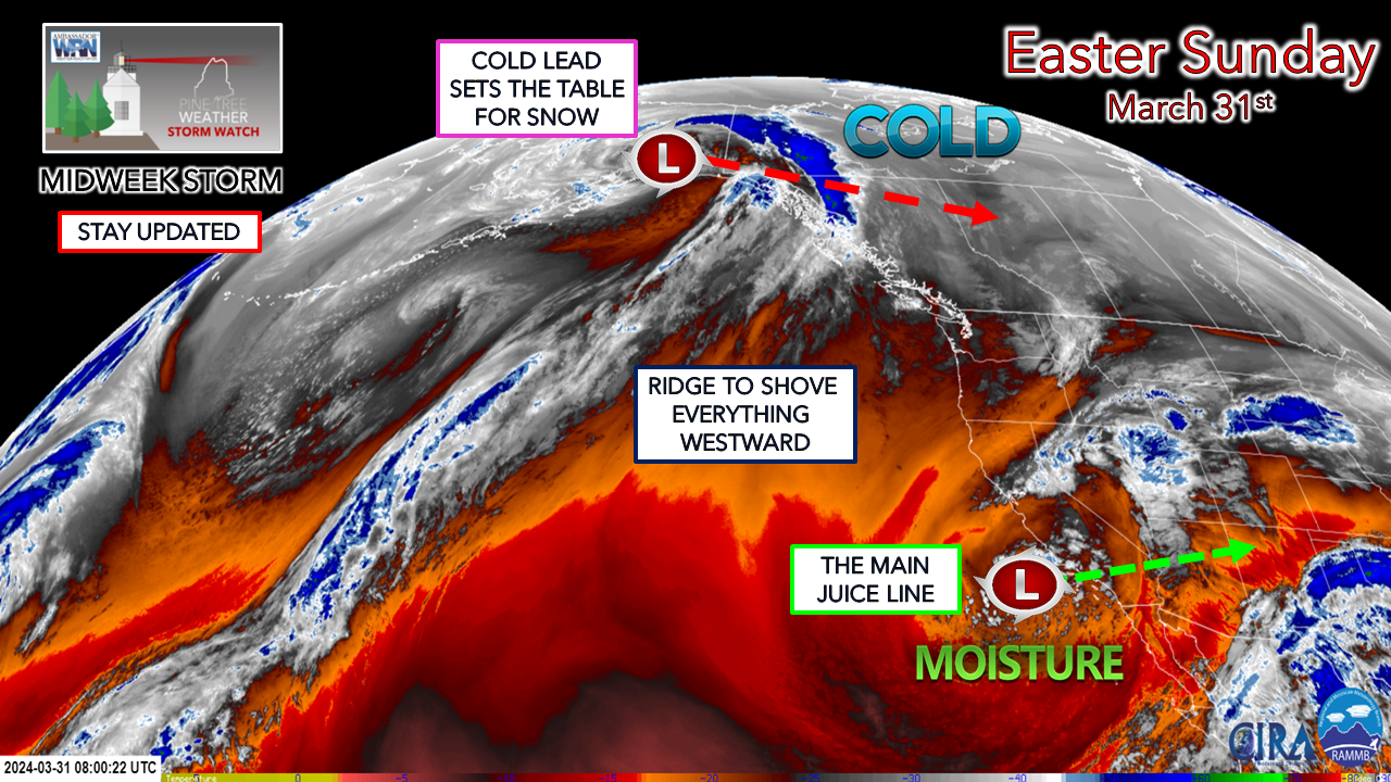 There are still some moving parts, but I have enough confidence to get the pencil out and discuss ideas.
A LONG DURATION EVENT APPEARS LIKELY… While the actual start time is still to be ironed out, the idea is for southern and western areas to see precipitation start Wednesday afternoon. As the storm intensifies, it is expected to stall or crawl around Cape Cod / South Shore overnight Wednesday and not deviate from that region until Friday, when a frontal boundary plunges in from the north to drive it out of the area later in the day, which shuts the precipitation off. THE COLD LEAD SETS THE TABLE… This is the key component for the snow-making machine, and it is expected to arrive ahead of the developing coastal low. The storm will drag in colder air aloft and at the surface as the storm intensifies. PRECIPITATION… A general 1-2” of liquid equivalent is expected south and east of the western mountains over to Katahdin, with lesser amounts to the north. Snow-to-water ratios are likely to be all over the place with fluffier snow, which is the idea for the higher elevations to a heavy, wet, pasty slop closer to the shorelines. Thus, figuring out how much of the frozen variety is expected to receive poses a daunting forecasting challenge. WIND / POWER OUTAGE CONCERNS… Given that the storm will intensify and potentially stall, crawl, and/or wobble to the south, this will be a long-duration wind event. Add the pasty wet snow aspect, and the power outage potential is more than likely here. The rough sketch of where the higher risk of outages appears south of a line from Fryeburg—Lewiston—Augusta—Bangor—Calais. It is important to stay tuned for the potential for areas north of that line up to the western mountains to the Katahdin region. SHORELINE IMPLICATIONS… The opening ideas for surf are in the 10-15 foot range, subject to change depending on storm intensity and track. Tides begin to build to new moon levels starting Wednesday. The key high tide of concern is in the 7 AM hour Thursday morning, with the Thursday evening high in the 8 PM hour, and the Friday morning 8 AM hour highs need to be monitored pending on how this unfolds. Another round of shoreline abuse is expected with battering waves and erosion. Flood potential is to be determined, but if the storm intensity holds serve in the 985mb-ish range, there could be some minor flooding Thursday morning at the very least. WITH THE GREATEST IMPACTS EXPECTED OVER THE MORE POPULATED AREAS OF THE STATE, this is your heads up to prepare for power outages, which could be long-term in some areas given the fact that this is a long-duration wind and heavy wet snow event. THIS IS NOT THE FINAL ANSWER. The forecast will be fine-tuned over the next couple of days. STAY TUNED. Enjoy your Easter holiday, and thank you always for your readership and financial support! - Mike |

Mike Haggett
|


