Cloudy and Showery South; Threat of Another Frost North Tonight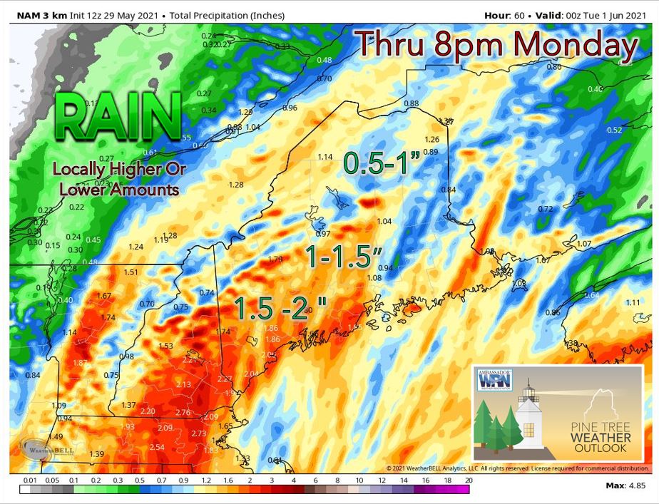 An area of low pressure passing south of the state this afternoon has led to cloudy skies and showery weather for the southern half of the state, including the South coast and Midcoast regions. Temperatures are stuck mainly in the mid to upper 40's in this part of the state due to a stiff ENE wind off of the ocean, overcast skies, and an approaching upper-level trough centered over the Eastern Great Lakes. Meanwhile, in the northern part of the state where skies are partly to mostly sunny, temperatures are warmer in the upper 50's to lower 60's. Tonight we will continue to see a chance for showers in the southern part of the state, favoring areas from Portland south. The skies look to stay mainly clear with light winds expected across the far northern areas, including parts of Aroostook County. This means that there is a threat of another frost tonight in those areas! 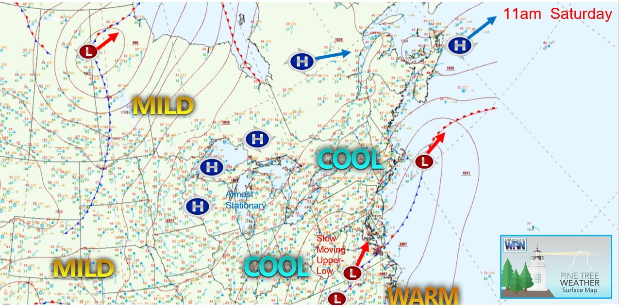 Rainy Tomorrow and Memorial Day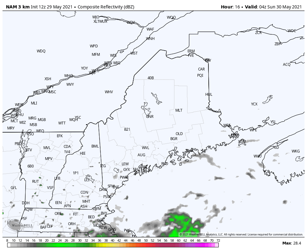 During the day tomorrow, clouds will likely overspread the rest of the state from S to N. Rain will move in from the south associated with an upper-level low moving towards our area from the Southeast US. Southern areas should see the rain move in by late morning with northern parts of the state seeing rain by evening. Unfortunately, Memorial Day is likely going to be a rainy one across much of the state. Southern areas of the state may see the rain taper off by the afternoon; however, it will still be chilly with many areas still stuck in the 40's and 50's. Expect a general 0.5" to 2" of rain (locally higher or lower) from this system when all is said and done which will be very beneficial given that some areas of Maine were abnormally dry preceding this event. Drier and Warmer After the HolidayExcept for some scattered showers, Tuesday should be dry across the state with more seasonable temperatures in the 60's and lower 70's. This is thanks to high pressure moving into our area from the west. Wednesday should feature abundant sunshine with above average temperatures expected for most. We may see the return of rain to the forecast later next week. Stay tuned for more updates! Temperature Outlook through the First Week of JuneThe bar graphs below display the projected daily high and low temperatures for the next ten days for Waterville, Bangor, Caribou, and Portland. After a chilly holiday weekend, all locations in Maine look to experience a general warming trend back to more seasonable temperatures this upcoming week. For reference, many locales in the state see a climatological high of around 70°F and a low of around 50°F during the first week of June. The steady warming trend looks to continue later in the week and into next weekend with the return of above to well above average temperatures likely and projected temperatures in the 80's for many locations in the state. 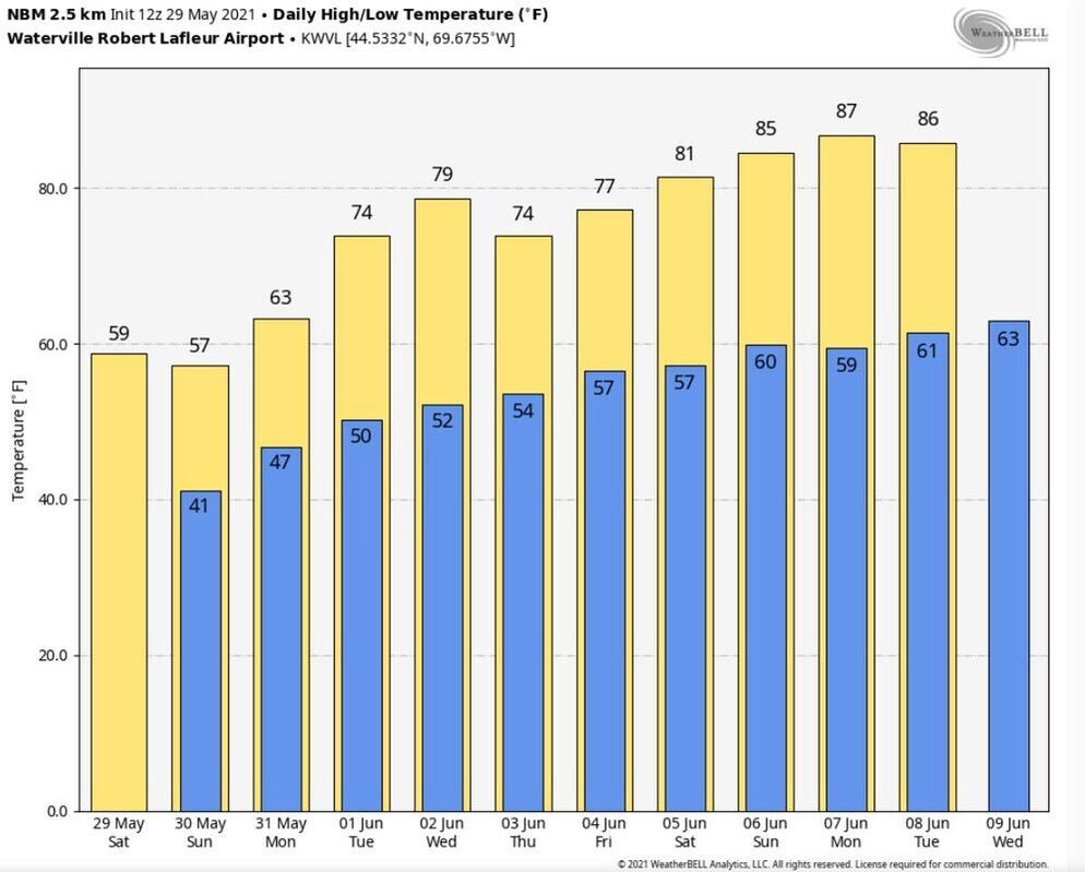 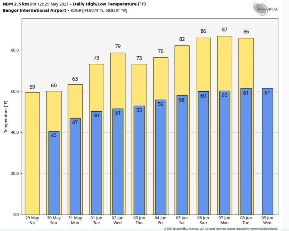 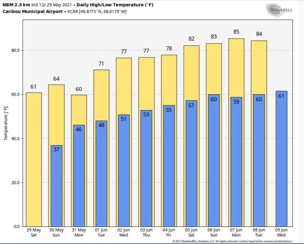 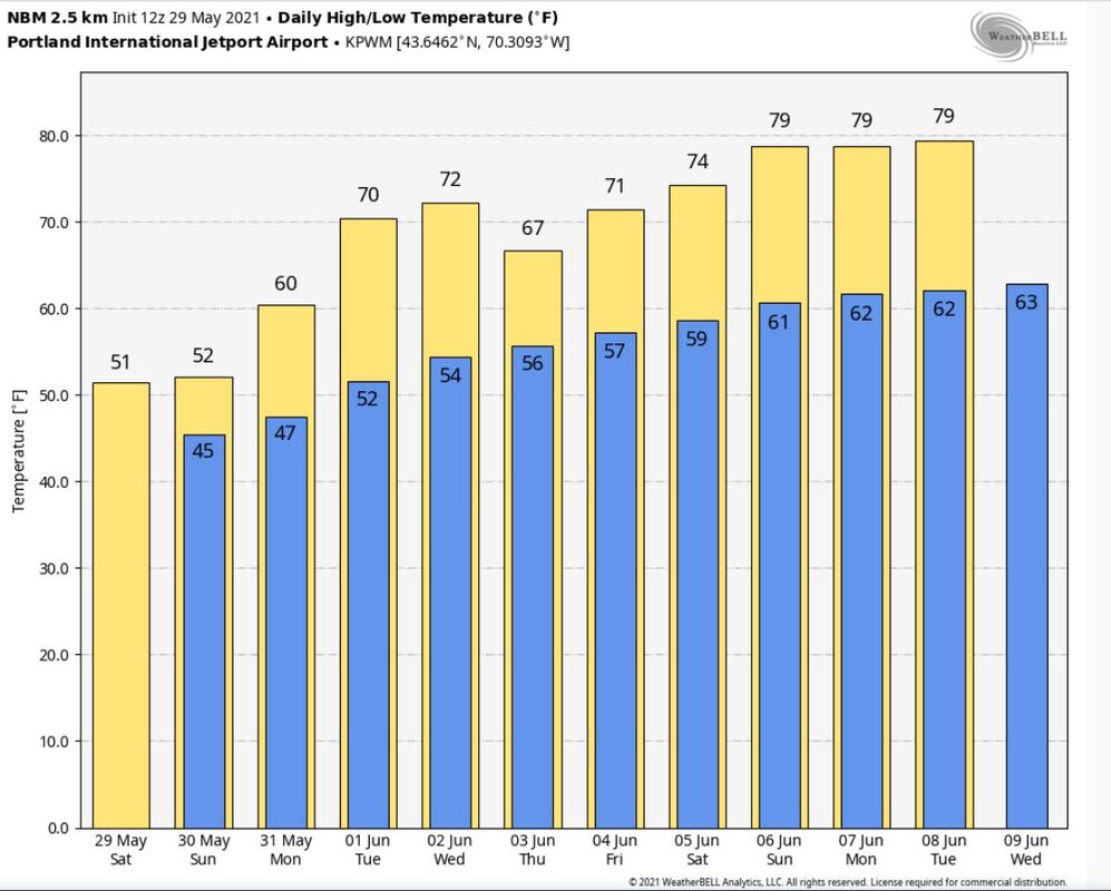 Join the weather community as a storm spotter!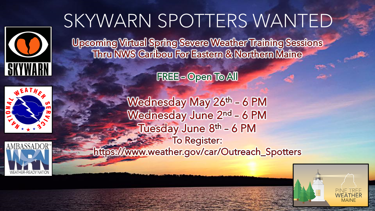 Here's a wonderful way to become active in the weather community and help the broadcast media and forecasters like myself with storm reports. This information is vital during and after an event for forecasting and alerting purposes. I can't tell you how many times I have seen the importance of these reports in the past 9+ years I have been involved. Pine Tree Weather followers have stepped up in the past and participated, and with the readership base continuing to grow, I know there are more out there. This is the spring/summer session which discusses severe weather, what to look for, and how to report it. These sessions run for about 90 minutes. They are fact filled, educational and interesting. You can get the whole family involved from the comfort and safety of home. Once completed, you will get your spotter ID, and will be ready for the season ahead. For those who trained for the winter session, this will complete your full year training. It's important to have both sessions done. The link to register is here ►https://www.weather.gov/car/Outreach_Spotters Be prepared to receive alerts and stay updated!
 For more information in between posts, please follow Pine Tree Weather on Facebook and Twitter. Thank you for supporting this community-based weather information source which operates by reader supported financial contributions. Thank you for your support! |

Mike Haggett
|