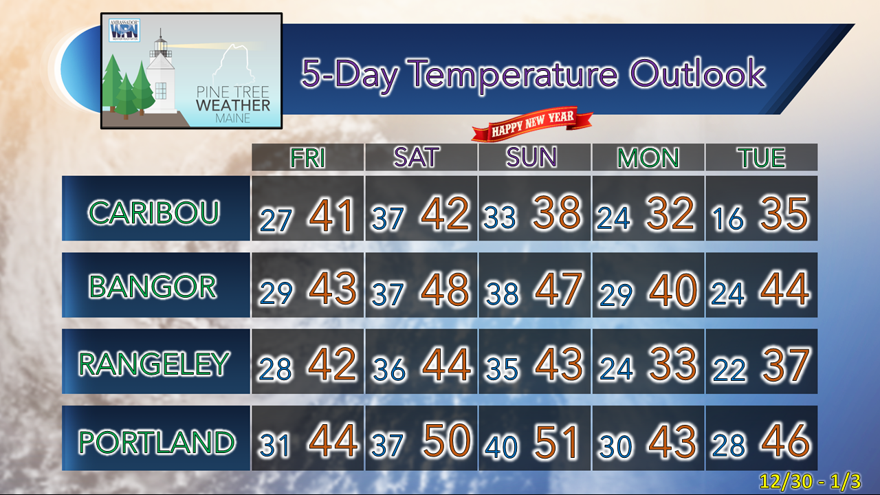
Deep cold to the north cut off for a whileThe good news is the impact on the heat bill takes a breather after the cold stretch that settled in after the Grinch storm. The bad news for snow lovers is that it will come at your expense. The snow pack is expected to go down. The mountains and north are likely to lose some, but I don't expect this warm pattern to completely wipe out what is on the ground there. Areas in the foothills down to the patchy snow that is left along the coast are likely going to see most of what is left gone by the time the pattern flips on Thursday of next week. 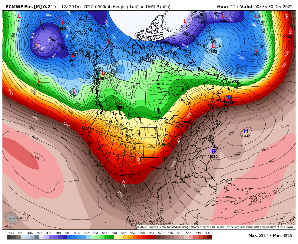 Thursday 7 PM to Tuesday 7 PM - A couple things going on in this loop of the 500mb (steering level at ~18,300 ft) and mean sea level pressure. The sequence of these charts show what is going on aloft and at the surface. Old Man Winter is winking at us letting us know he's still around but is hanging out for the most part at above 30°N latitude. A pattern resembling more of early October or April with temperatures more like November is the trend to end the year and start the new one. Starting next week, there are likely to be some record warm lows and a chance to make a run at warm highs. The storm that passes through on Sunday cools us down a touch briefly before the warmest air of the stretch builds in for midweek. An inside runner approaching the Great Lakes is the next system to monitor heading into Wednesday, and then temperatures are expected to fall back to around normal late week. Strong wind events hit recent high markWith the recent windstorms that have impacted the region, I decided to do some digging and look at recent data since 2005 which focuses on the number of High Wind Warnings and Wind Advisories that have been called by our National Weather Service offices in Gray and Caribou. While we didn't hit the high point of 2010, it is important to note that since 2015, the number has been trending upward. 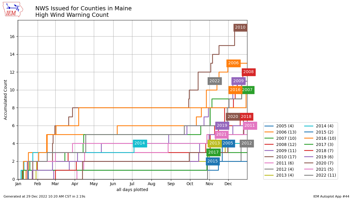 The definition of a High Wind Warning is for high winds excluding those directly associated with severe local storms, hurricanes, and winter storms for a) sustained wind speeds of 40 mph or greater lasting for 1 hour or longer, or b) winds of 58 mph or greater for any duration, in case you are curious. These are the ones where numerous to widespread power outages are expected. In 2022, the state had 11 of those issued, a tie for 4th since 2005. 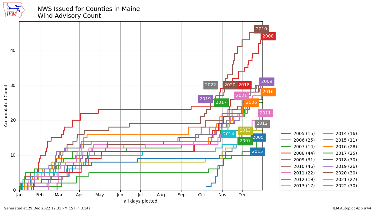 A Wind Advisory is issued for winds excluding those directly associated with severe local storms, tropical cyclones, and winter storms for a) sustained wind speeds of 31-39 mph lasting for 1 hour or longer; or b) wind gusts of 46-57 mph for any duration. These are the ones where isolated to spotty power outages are possible. In 2022, the state had 30 of those issued. Since some of the High Wind Warnings were also combined with Wind Advisories, it's not correct to think we had 41 different wind events, even though it may have seemed that way. It is the highest number combined since 2015. I am not one to point blame on any one specific reason as to why this going on, other than to say it is going on. While it could be easy to point fingers at how fragile the power grid is, there is numbers to point out that we are getting hit with strong wind events more frequently. I am not trying to incite any sort of political or scientific riot here. That is not my thing and I avoid it at all cost. If you want to take the information elsewhere for that debate, that is up to you, just not on my media pages, please, as I will not tolerate it. The bottom line here is now that you've seen the numbers, you know that it is happening more often, so it is important to keep your storm supplies up to snuff and pay attention to the forecast. We'll get another one before too long as we are into the stormy and windy time of the year through spring, and it is important to be prepared ahead of time. Losing some snow pack, getting some rain this weekend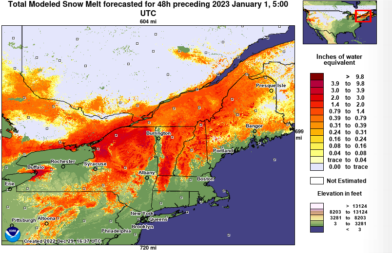 Since I tend to be more of a glass half full guy and I'll just say this could be worse. This will help clean up the ice build up in areas that isn't good from the Grinch Storm. Another upside here, is the snow melt happens ahead of the rain on the way, and with what rain comes, flooding concerns appear very low at this point. I can't rule out a few localized spots where there may be ice jams, but nothing major here. 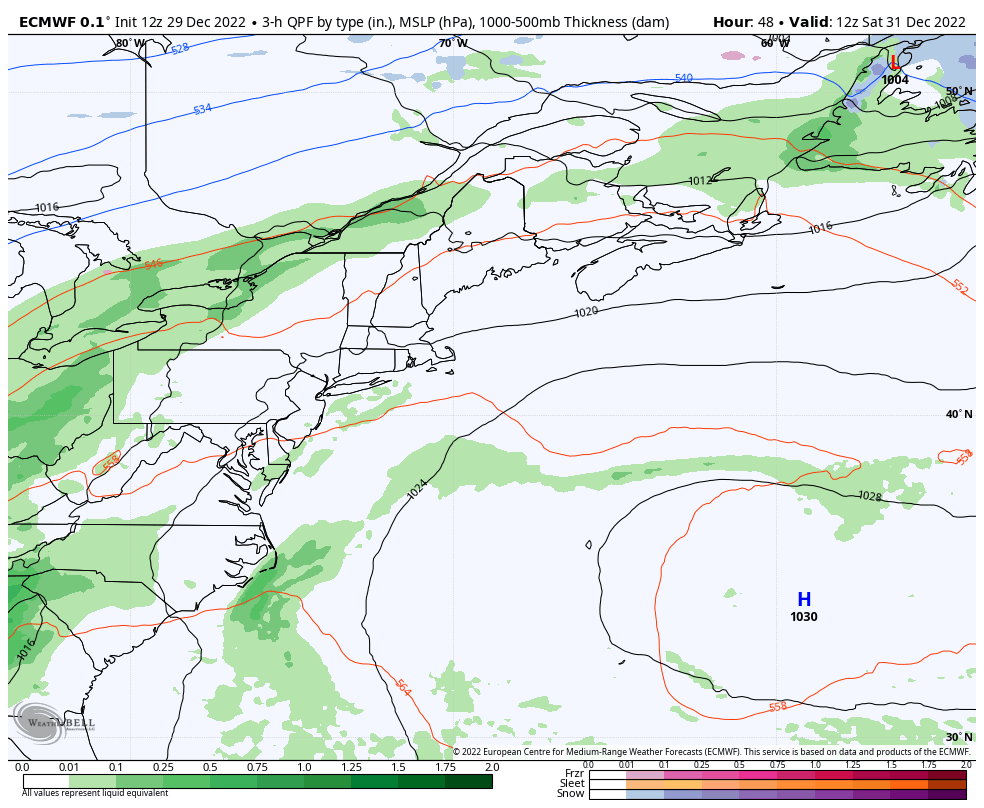 Saturday 7 AM to Monday 4 AM - The idea of a backside plowable snow that I thought might happen over the mountains and north appears unlikely. Salt & sanding may be required as the back edge passes through Sunday afternoon for up country, but that should be about it. Showers break out over the mountains and north on Saturday, become more numerous heading into Sunday before clearing out from west to east Sunday night. If you are out on the roads Saturday night, expect areas of fog which could be locally dense, especially in areas with a snow pack. Hopefully folks who imbibe to ring in the new year will find a spot and stay there, and not get behind the wheel. It is Amateur Night, however. 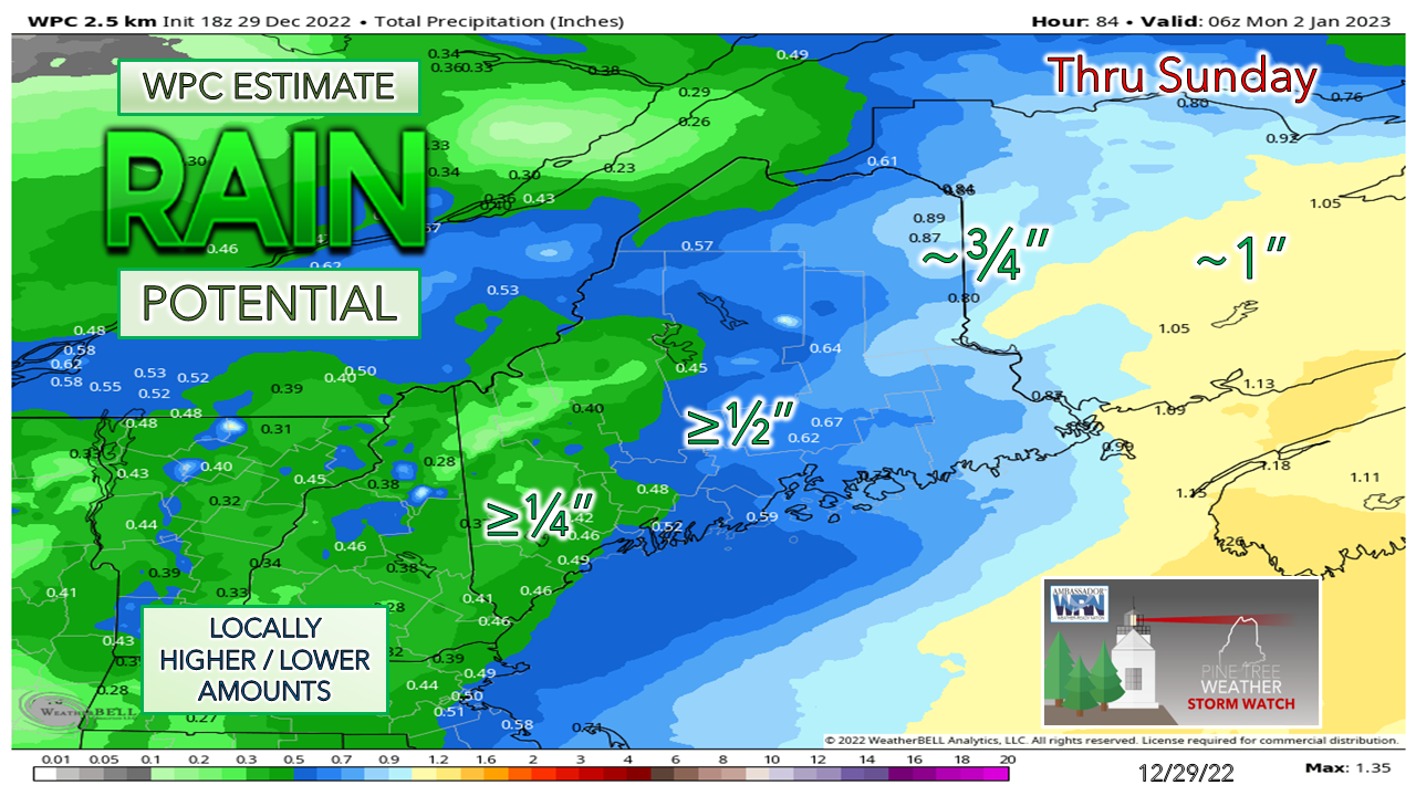 Ideas on rainfall have teetered here and there, but far eastern areas from Van Buren south to Machias are likely to see the most liquid from this. The storm starts off rather flat before intensifying on it's way into the Canadian Maritimes, which may help the western mountains with lower end rainfall. Way Down East has the best chance to pick up an inch. The higher elevations could see some pockets of freezing rain and/or drizzle Sunday morning as colder air filters in, so there could be some slick spots. Thankfully, not much concern for wind with this, but it will pick up on the backside Sunday night into early Monday with gusts behaving themselves in the 20s, with 30s possible for the mountains. We'll cool down slightly on Monday before the ridge moves in midweek. $300 needed to make the 2023 budget... |

Mike Haggett
|