Pine Tree Weather
  • DISCUSSIONS
  • DONATE
  • WEATHER WALL
  • MAPS
  • RAIN OUTLOOK
  • SEVERE
  • MARINE
  • CPC OUTLOOK
  • Kennebunk
  • MY BIO
  • PTW IN MEDIA
  • OBSERVING WEATHER
  • INTERNSHIPS
  • INTERN ALUMNI
  • DISCUSSIONS
  • DONATE
  • WEATHER WALL
  • MAPS
  • RAIN OUTLOOK
  • SEVERE
  • MARINE
  • CPC OUTLOOK
  • Kennebunk
  • MY BIO
  • PTW IN MEDIA
  • OBSERVING WEATHER
  • INTERNSHIPS
  • INTERN ALUMNI

A bit of a mess to contend with for interior areas Sunday into Monday

3/28/2020

Comments


Storm over the midwest brings a mix to the region

Picture
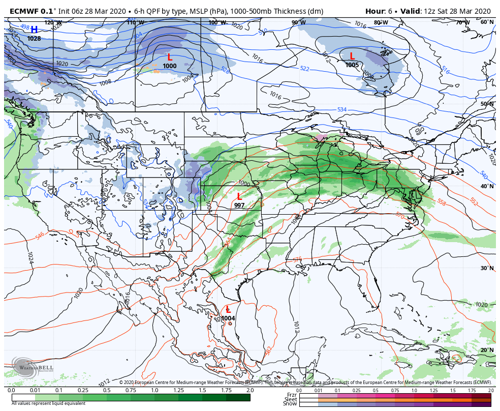
It's kind of ironic that part of my school study this week is on cyclones and fronts. This is what we have going on here. A storm intensifies quickly over the midwest, and could bring a rough batch of weather around the Great Lakes region and the Ohio Valley. A warm front attached to it moves northeastward into New England on Sunday. (Note how the storm over the Great Lakes weakens as it moves eastward. I will talk more about that.)  The result for our region is rain and snow, with a bit of a mix possible for the western interior. 
Picture
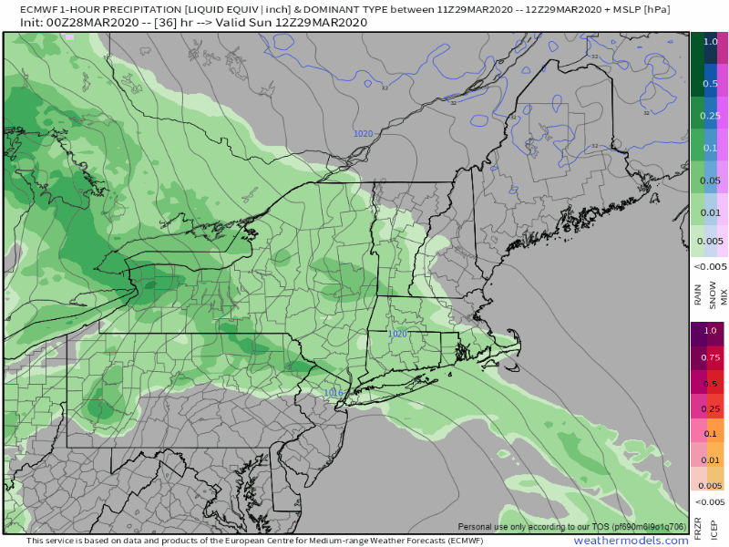
Precipitation arrives over western and southern areas Sunday morning, and then moves to into the north and east Sunday evening into early Monday. As the storm weakens, steadier precipitation turns into shower activity which becomes widely scattered during the day on Monday, and dissipates overnight into Tuesday morning. 
Picture
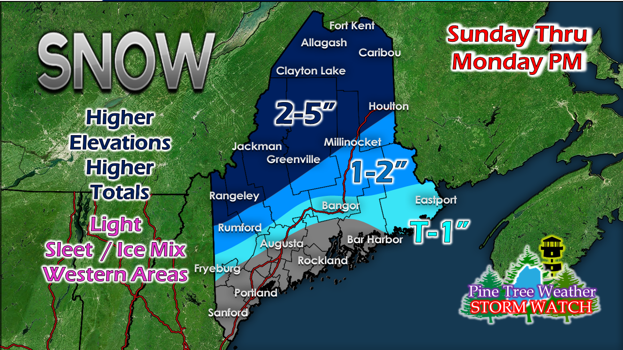
Most of the snowfall and mixed precipitation falls Sunday night into Monday morning. A poorly organized coastal low taps into colder air from high pressure over the Bay of St. Lawrence and causes temperatures to fall. This will create some slick spots over the interior Sunday night into Monday, and again Monday night into early Tuesday. 

I do expect some light sleet and freezing rain to come for interior western areas, but I don't expect accumulations to be an issue. 

Upper level energy to keep pattern rather unsettled

Picture
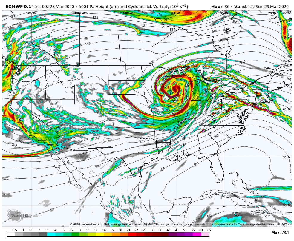
Notice how tightly wrapped the upper level energy is over the midwest, then weakens as it moves eastward. As what happens at the upper level also transfers to the surface. The storm becomes occluded, which weakens the impact on our region. As the upper energy and surface low decays, the energy and moisture associated with it dissipates and becomes disorganized. Due to a traffic jam over the north Atlantic, this remnant energy will hang around over our region for much of the week. This will bring clouds at times to the area, but otherwise the outlook appears dry until late week. 

Temperature outlook through Monday
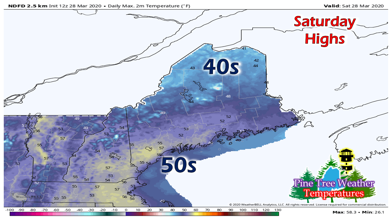
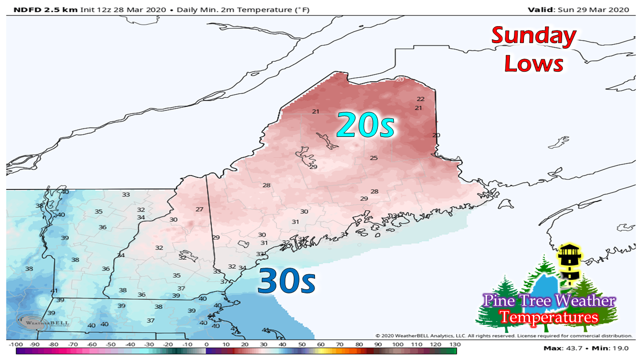
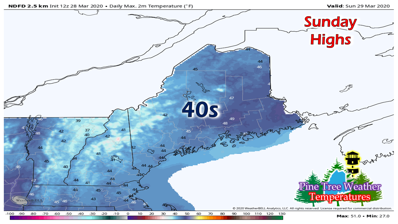
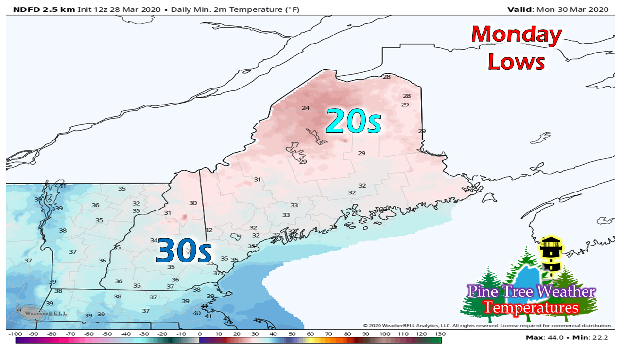
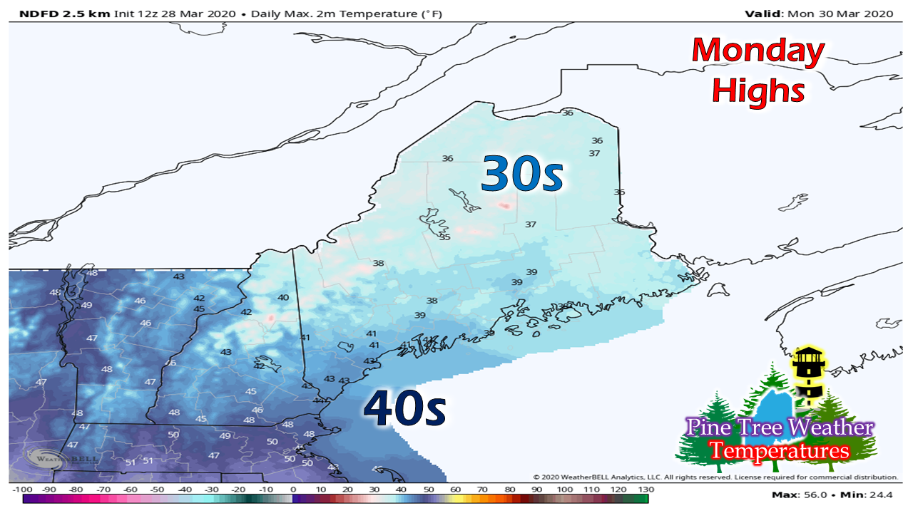
Picture
Picture
Picture
Picture
Picture
Comments
    Picture

    Mike Haggett
    Kennebunk, ME

    Weather-Ready Nation
    Ambassador

    Certified Weather
    Forecaster
    Penn State '21

    American Meteorological Society

    National Weather Association
    ​
    ​SKYWARN-CWOP

    Matthew 19:26


    DONATE

    Picture
    Picture
    Picture
    Picture
    Picture

    Picture

    Picture

    Picture

    Picture

    Picture

    Picture

    Picture

    Picture

    Picture

    Picture

    Picture

    Picture


    Archives

    April 2025
    March 2025
    February 2025
    January 2025
    December 2024
    November 2024
    October 2024
    September 2024
    August 2024
    July 2024
    June 2024
    May 2024
    April 2024
    March 2024
    February 2024
    January 2024
    December 2023
    November 2023
    October 2023
    September 2023
    August 2023
    July 2023
    June 2023
    May 2023
    April 2023
    March 2023
    February 2023
    January 2023
    December 2022
    November 2022
    October 2022
    September 2022
    August 2022
    July 2022
    June 2022
    May 2022
    April 2022
    March 2022
    February 2022
    January 2022
    December 2021
    November 2021
    October 2021
    September 2021
    August 2021
    July 2021
    June 2021
    May 2021
    April 2021
    March 2021
    February 2021
    January 2021
    December 2020
    November 2020
    October 2020
    September 2020
    August 2020
    July 2020
    June 2020
    May 2020
    April 2020
    March 2020
    February 2020
    January 2020
    December 2019
    November 2019
    October 2019
    September 2019
    August 2019
    July 2019
    June 2019
    May 2019
    April 2019
    March 2019
    February 2019
    January 2019
    December 2018
    November 2018
    October 2018
    September 2018
    August 2018
    July 2018
    June 2018
    May 2018
    April 2018
    March 2018
    February 2018
    January 2018
    December 2017
    November 2017
    October 2017

Proudly powered by Weebly