
Busy pattern ahead If you love winter, or even if you don't like it, you are going to get it. The pattern has come out of dormancy. After the light taste on Friday, a full plate comes Sunday. We'll get a bit of a break from precipitation on Tuesday, then another storm could bring potential issues the second half of next week. Friday's nuisance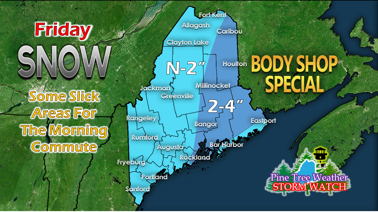 It seems like I have talked about this event for days. Only subtle changes here. Parts of western and southern areas get flakes to a couple inches. Banding over eastern areas may bring a few more. There are no advisories posted by the National Weather Service, so consider this your advisory to take it easy on the roads tomorrow morning. This should be done in western and southern areas by mid-morning to noon. early to late afternoon for eastern areas. The wind picks up from another arctic front, and the temperature goes down Friday night into Saturday. It will be this cold that sets the table for Sunday's storm. Winter Storm Watch posted statewide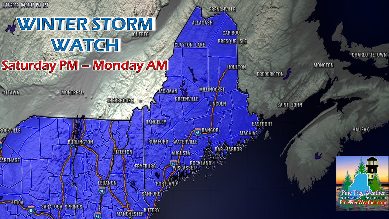 I totally expect this watch to elevate to a warning. The question remains if the coastal counties get issued blizzard watches or warnings. It's certainly possible. The deep cold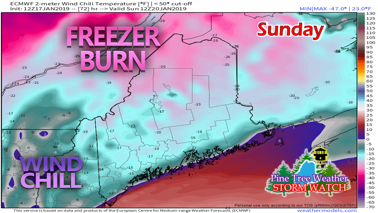 With the storm track. and a north / northeast airflow, cold air is going to bury itself over the state, even the far south and shoreline areas. Actual high temperatures appear to be in the single digits for the interior to teens along the coast. There could be some debate whether the roof top of the state breaks 0°. NWS Caribou already has a Wind Chill Advisory posted for The Crown for Saturday from 1 AM to 2 PM. That may get extended. Time will tell if other parts of the state get wind chill advisories for Sunday. Looking at this model idea, I suspect there could be. The whole state will be dealing with below zero wind chills as it appears for now. It will be a brutally cold event. Timing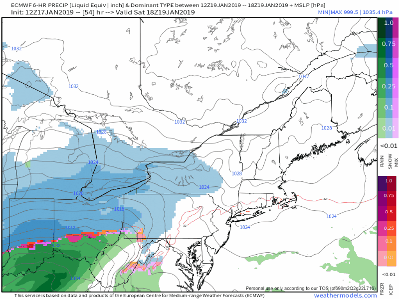 Timing of the event has snow developing over western ans southern areas Saturday evening. Snow will become heavy at times in the wee hours of Sunday morning over western and southern areas, then shift northeastward. Snow tapers to snow showers by Sunday night, but additional accumulation is likely into Monday. The snow showers end Monday morning over western and southern areas, and by the afternoon for eastern and northern areas. Snow totals increased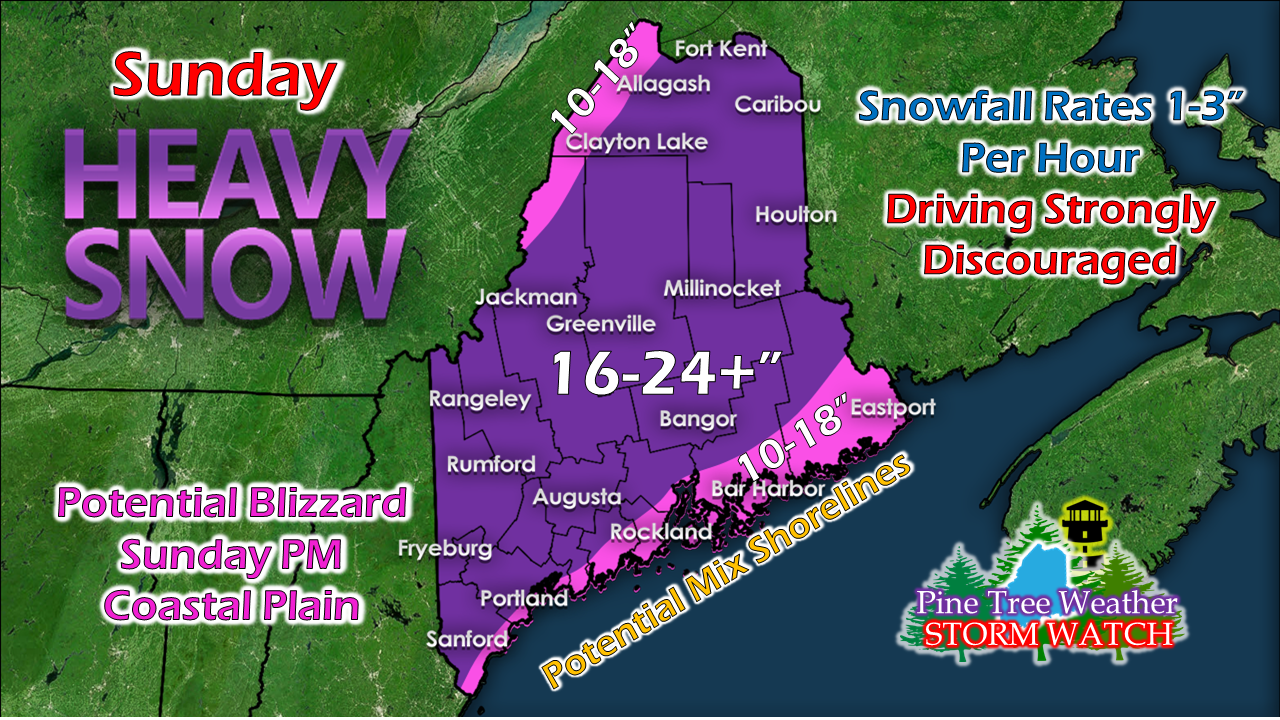 This is going to be a very fluffy snow over the interior. Coastal areas may have to deal with some sleet and perhaps freezing rain from the MidCoast up through Eastport. Since this is powder snow, it is going to blow and drift all of Sunday, Monday, and into Tuesday morning. Snow appears to fall in the 1-3" per hour range. which will make travel dangerous as the plow crews will have difficulty keeping up. I'll keep saying this: go to where you need to be by Saturday night and stay there until Monday morning. The jackpot area for this one appears over eastern Maine from around Millinocket to Bangor east to Danforth and Vanceboro. The ski hills won't find any complainers. Snowmobilers, sledders, snowshoers and cross country skiers will get the load they have waited for along the coastal plain. This is not the final answer. If there is an area to be tweaked, it will be shorelines. Coastal concerns continue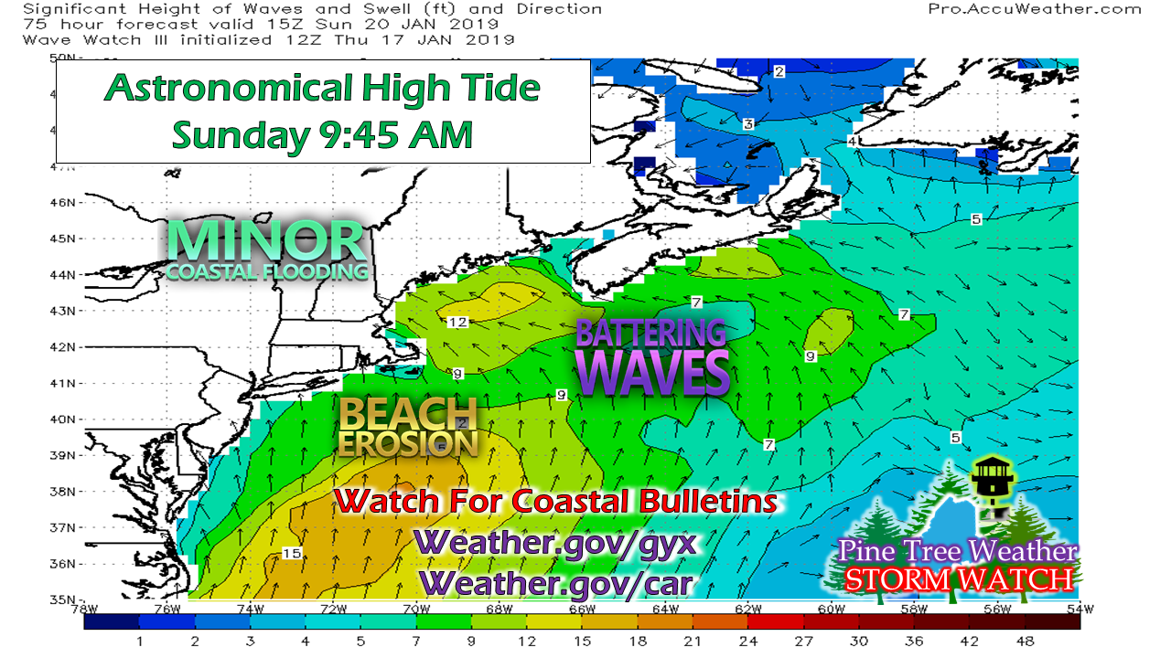 The main concern will be for the Sunday morning high tide around 9:45 for some minor flooding and splash over. The projected time of storm surge appears in the afternoon around low tide. Expect surf to linger into Monday, and splash over potential to continue with it. Outlook through Tuesday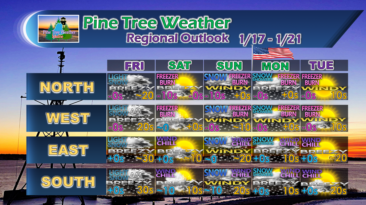 More updates coming. Stay Tuned!
For the latest official forecasts, bulletins and advisories, please check in with the National Weather Service in Gray for western and southern areas, or Caribou for northern and eastern parts of Maine. For more information from me, please follow the Pine Tree Weather Facebook page and my Twitter feed. Your financial donations are much appreciated to keep this site funded and for further development. I sincerely appreciate your support not only financially, but also in sharing my efforts with others. Always stay weather aware! - Mike |

Mike Haggett
|


