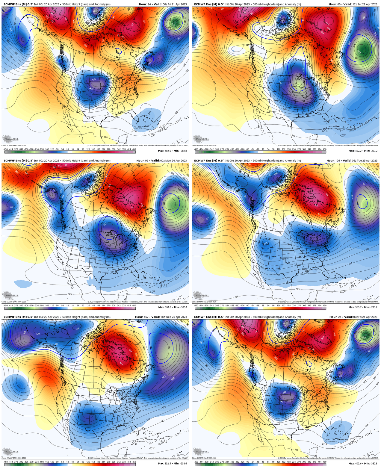
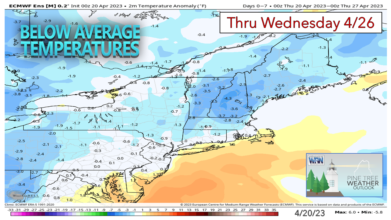
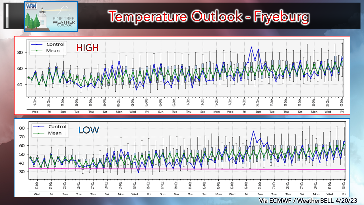
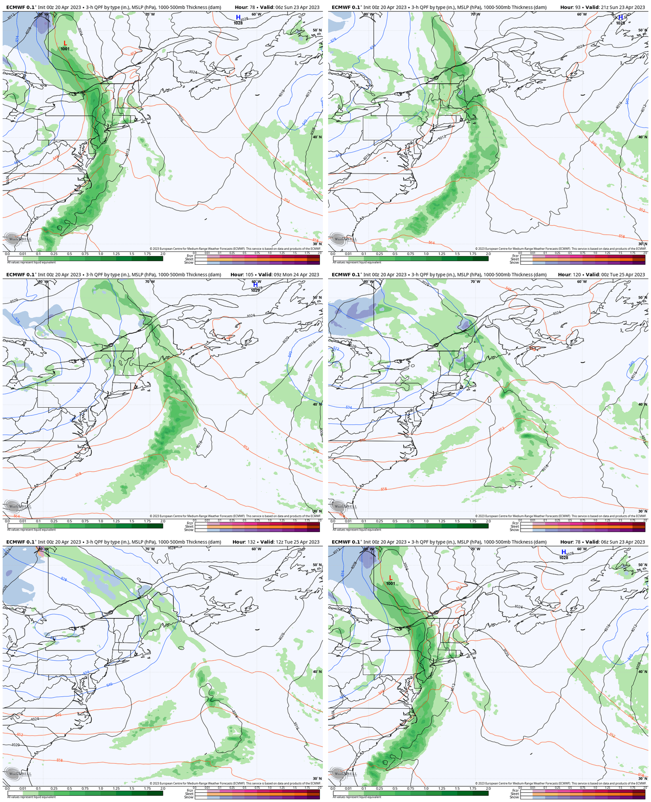
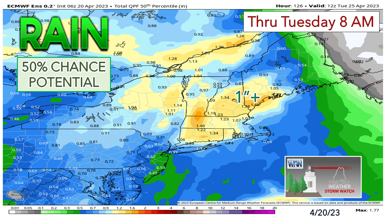
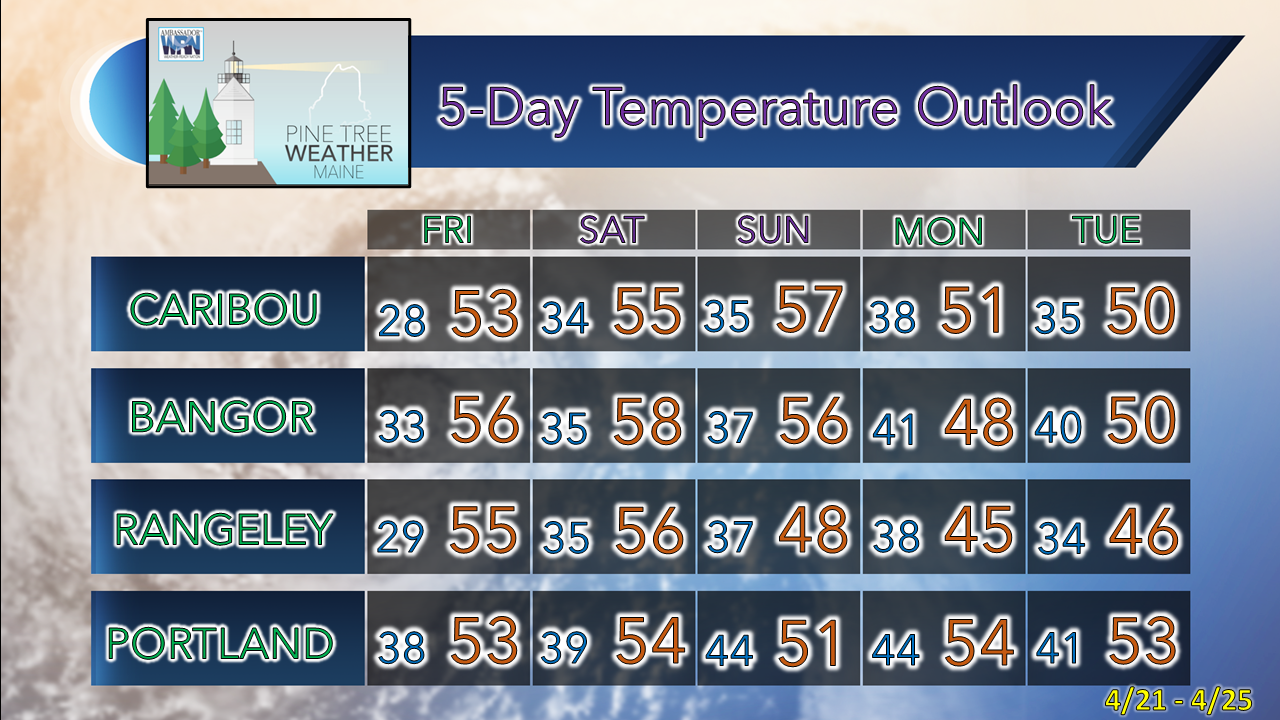
April is AprillingA look here at the 500mb steering level pattern at roughly the 20,000' altimeter level shows the strong ridging over Greenland and northeastern Quebec and the setup of a pseudo-omega block to the southeast. With upper-level disturbances pinwheeling around it, it is expected to keep Maine seasonably cool with unsettled conditions beginning Sunday over southwestern areas and continuing statewide through the middle part of next week. A strong ridge is expected to build over the eastern Pacific by midweek which will keep most of the country unsettled and cool as disturbances funnel down from the Arctic. While the region was teased with warmth of a week ago, the pattern of the blocking and stalling of an upper level low much like the region experienced this past week will return heading into the last full week of April. Temperatures are expected to be cooler than normal through Wednesday and may continue that trend into early May. Temperatures slow to rise into MayFor the gardeners and those curious what the temperature trend appears at this point, I focus on Fryeburg here to get a clearer picture of the overall idea, free of influence from the ocean. For those getting the itch to get vegetable gardens going, I'd keep the seedlings going inside and keep them there. Looking at the temperature low on the chart, I added a pink line that indicates 32° for frost concerns, and it appears that chance will be there through mid-May at least. For those that use Mother's Day as the bellwether to get plants into the ground, it may be wait and see if that might work. A decent charge of rain on the way Sunday into MondaySunday 2 AM to Tuesday 8 PM - A sharp trough digs to the southeast on Saturday and runs up against a strong ridge that keeps the area dry to start the weekend. That ridge weakens as the upper low strengthens and spins a long wave cold front through the area. Sunday appears damp over southwestern areas, where the rest of the state stays mainly dry through most of the day. All areas get wet from Sunday night into Monday. With the block on to the north and east, this upper-low gets caught in it and crawls at a snail's pace through the middle part of the week. Expect gray skies and showers through Tuesday, and don't be surprised if they continue in some parts of the state into Wednesday, and perhaps Thursday. For an area that has done well with precipitation since October, a dry April has put the brakes on that. Month to date, Portland is down 1.8", Augusta 1.38", Bangor 1.12" and Caribou 0.69" from normal in the rain catch. The storm on the way will help get much of the region out of those deficits and may turn a few areas into a surplus by the time the system departs midweek. A 50% chance of 1"+ of rainfall is a fair bet that some areas may reach 2" or more. Folks that live in the north country where there is still a snowpack should be on alert for the potential for washouts and flooding. Temperature outlook through TuesdayFor Caribou, the average high for April 20th is 50° with an average low of 32°. For Portland, it is 56° for the high and 37° for the low. Cool will be the rule on the high end for most areas in the near future. Pine Tree Weather is funded from followers like you. I would appreciate your financial support. Click here for how you can contribute. You may not like the weather, but I hope you like what I do! Please hit the like button on Twitter and Facebook, and share! Stay updated, stay on alert, and stay safe! - Mike NOTE: The forecast information depicted on this platform is for general information purposes only for the public and is not designed or intended for commercial use. For those seeking pinpoint weather information for business operations, you should use a private sector source. For information about where to find commercial forecasters to assist your business, please message me and I will be happy to help you. |
Mike Haggett
|

