
A blustery Wednesday It was a chilly and windy start in Wells Beach this morning as a result of the storm system to the east. Wind advisories have been dropped by both the Gray and Caribou weather offices as winds have dropped below threshold. With the Maritime low exiting, expect breezy conditions to continue through Thursday The latest on the storm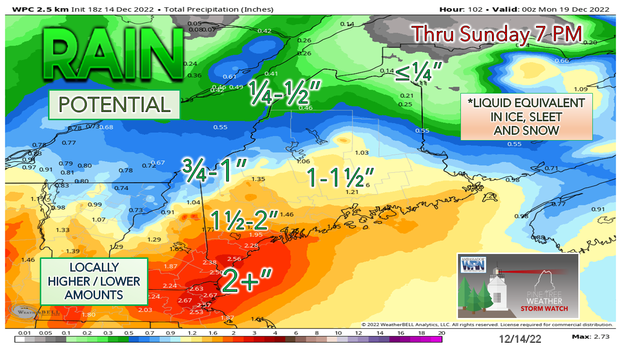 The one thing I haven't discussed much about is the amount of liquid involved with this system. It's a lot. With the high water content involved here, there is a lot of heavy snow involved, especially south of the mountains. This is heart-attack level concerns for shoveling here. Along with that, comes power outage concerns, which is another drum I have beat on all week. Between the heavy wet snow along with wind gusts 20-30 mph (coast 30-40+), there is potential for numerous power outages south and east of the mountains. 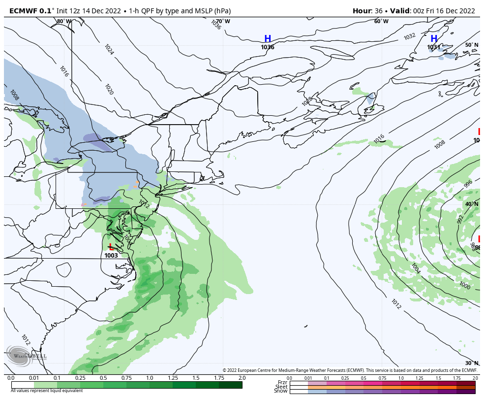 Thursday 7 PM to Sunday 7 PM - The track situation is now down to fine tuning. The general idea is for the low to track into the Gulf of Maine. There is potential for a stall out and for the surface low to run a counterclockwise loop. In this case, that would keep precipitation going longer. How much longer is not clear yet. My idea of timing is listed out in the forecast at the bottom of the post, and the end time for now is subject to change. 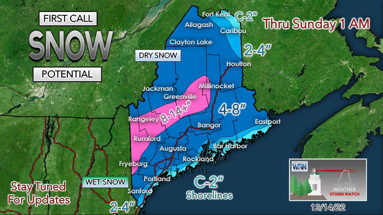 Winter storm watches have been issued for western and southern Maine with the exception of the shoreline areas. The word from the Caribou office is they are monitoring the situation and will decide when it is appropriate to issue watches or advisories overnight. The snowfall map is a moving target at this point for the coastal plain given the track of the low. A jog 30 miles east / southeast could be the difference of a couple inches and 4-8". For the snow removal crews along the shoreline counties, you should be ready in case your services are required. Further north into the mountains, confidence is high that snow and plenty of it will fall, and the closer to the Quebec border, the drier the flakes get. I went 8-14" for the peaks and could see 16-18" for the taller ski hills. The bottom line here for areas south and east of the mountains is BUST POTENTIAL is HIGH. The further southeast the low, snow totals go up. The closer to the shoreline, snow totals go down. Given the amount of water involved with this to the south, a sharp gradient cut-off is a fair bet if the forecast track stays close to current ideas or moves closer to the coast. Current deficit for 2023 = $1,100 ... please support! Five day forecast through MondayTHURSDAY BREEZY CONDITIONS STATEWIDE Statewide: Sun & clouds to start, increasing clouds during the day Mountains: Snow showers possible Wind: N/NE 5-15 G20-30 Lows in the 20s for most Highs 30s North & Mountains, around 40 south and east Windchill 20s/30s FRIDAY WINTER STORM WATCH HEAVY WET SNOW POTENTIAL WIND INCREASING DURING THE DAY INTO OVERNIGHT SATURDAY TRAVEL IMPACT CONCERNS POWER OUTAGE POTENTIAL South, Mountains, MidCoast: Precipitation begins early Friday, expands northeast by midday North & East: Mainly cloudy with precipitation beginning Friday afternoon into the overnight Saturday Wind: E/NE 5-15 G20-30 for the interior, 30-40+ coast / mountains Lows 20s for most, 30s along the coast Highs 30s North, near 40 shorelines Windchill 10s/20s SATURDAY WINTER STORM WATCH HEAVY WET SNOW POTENTIAL WIND CONTINUES TRAVEL IMPACT CONCERNS POWER OUTAGE POTENTIAL Precipitation continues through the day, ending Saturday night over the south. Snow showers continues for the north, mountains and east into Sunday. Wind: NE 5-15 G20-30 shifting NW 5-15 G20s over the west & south in the afternoon. Lows in the 20s North & Mountains, 30s elsewhere Highs in the 30s over the interior, 40s along the coast Windchill 20s/30s SUNDAY BREEZY CONDITIONS STATEWIDE SNOW CONTINUES NORTH, MOUNTAINS, EAST North, Mountains, East: Occasional snow, ending overnight Monday South: Mostly Cloudy with a chance of a snow shower, sunny breaks possible late day Wind: NW 5-15 G20-30 Mountains & South, NE 5-15 G20 North & East Lows in the 20s for most, around 30 east Highs in the 30s for most, around 40 along the shorelines of the southwest coast Windchill mainly in the 20s MONDAY BREEZY CONDITIONS STATEWIDE Mountains & North: Mainly cloudy with a chance for snow showers East: Morning snow showers possible with gradual clearing South: Sun & clouds Wind: NW 10-20 G25-35 (mountains 40+) Lows in the 20s for most Highs in the low 30s north and mountains, mid-30s to around 40 coastal plain Windchill 10s/20s Thank you as always for your support! If you like what I do, please hit the like button on Twitter and Facebook, and please share! Stay updated, stay on alert, and stay safe! - Mike NOTE: The forecast information depicted on this platform is for general information purposes only for the public and is not designed or intended for commercial use. For those seeking pinpoint weather information for business operations, you should use a private sector source. For information about where to find commercial forecasters to assist your business, please message me and I will be happy to help you. |

Mike Haggett
|


