
All the players on the stage for the rest of the week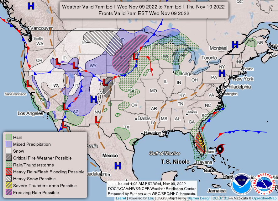 High pressure over Maine drifts to the southeast as we head into Thursday. That high will be the main steering mechanism for what will be left of Nicole. The frontal boundary bringing the kitchen sink of precipitation variety over the Midwest hooks up with Nicole and heads northeast Friday night into Saturday. A near average temperature day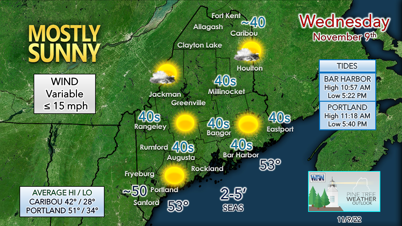 With the cloudless sky, a chilly start is on tap, but temperatures should warm up above freezing fairly quickly by mid-morning. With less wind, it won't feel as cool as Tuesday. Some high clouds may filter in over the north country in the afternoon. With dew points in the 20s, hydration is the key to avoid fatigue. Nicole and potential impacts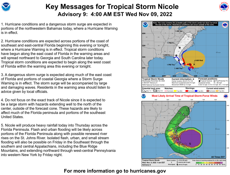 While most of the key messages from the National Hurricane Center focus on the southeast, what is important for our region is number four. The storm is expected to be large and expected to grow wider as it heads northeast as the increase in latitude expands tropical systems. Add to the fact that the storm is transitioning from tropical to synoptic with a negatively tilted trough to intensify it, it's a complex set up with several moving parts. 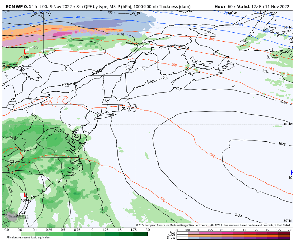 Friday 7 AM to Saturday 10 PM - A rough idea on timing shows the first of the rainfall reaching southwestern areas by Friday evening. Moderate to heavy rain showers with the possibility of thunderstorms are possible expands statewide Friday night into Saturday. The rain is expected to end from west to east Saturday afternoon into early evening. It is important to note here that the European deterministic idea shows multiple areas of low pressure forming along the cold front. Energy and moisture from Nicole are expected to transfer along the boundary and create a new intensifying parent low over the Canadian Maritimes on Saturday. Remember that I said that there are several moving parts? There are all kinds of wiggle room and surprise potential given this set up, which could lead to overperformance depending on how all the pieces come together. This is not the final answer, just an idea at this point. 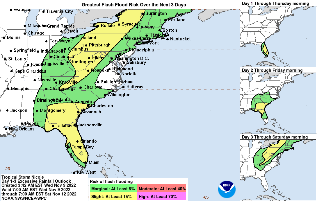 The Weather Prediction Center has the region in the Day 3 Outlook for a low risk of flash flooding, which makes sense given the tropical influence. Much of the eastern part of the country appears to get a soaker out of this. Current track of an inside runner through Western New York on up into the St. Lawrence River favors the heavier rain to the north and west of Maine. 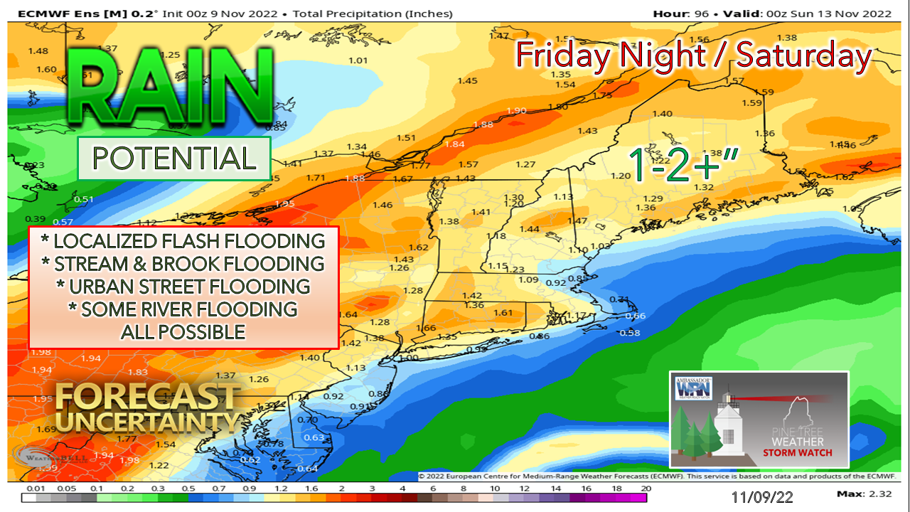 As operational and deterministic models continue to jump around, I am not taking the bait with what they are selling at this point given all the moving parts. The idea of a general 1-2" of rainfall with upwards of 3" for the mountains is a fair bet for now. With high precipitable water values and moist dew points comes the risk of locally heavier amounts of rain from downpours and any thunderstorms. While it has been a couple weeks since the area has received any rain of benefit, the river levels are up enough where there could be some flooding. Folks travelling Saturday should be aware of ponding on roadways, reduced visibility and flash flooding.  Whether you’re on the road or camping, will you be ready for sudden flash flooding? Make sure to enable Wireless Emergency Alerts on your phone. If flooding occurs while you’re outdoors, immediately get to higher ground, and NEVER enter floodwaters in a vehicle or on foot. weather.gov/safety/flood 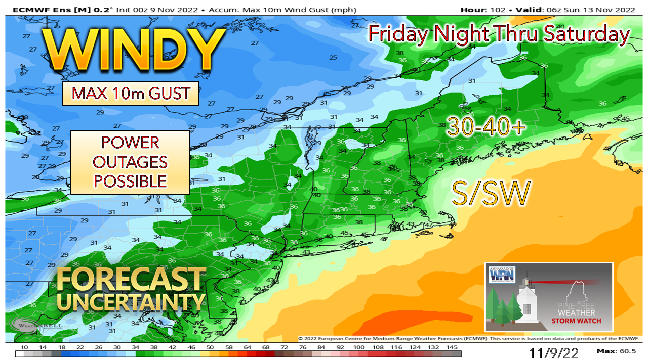 The National Weather Service is monitoring the low-level jet stream and downdraft impacts of it regarding a potential wind advisory. Expect the shorelines and higher elevations to see the stronger gusts. Power outages are certainly possible given the dynamics here, so prepare accordingly. 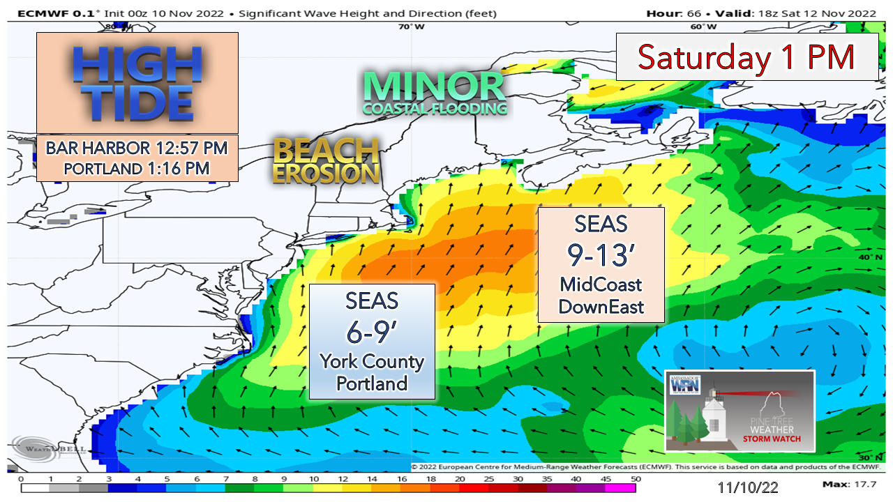 Another concern will be for the shorelines, especially to the east of Portland. Tides are coming off their astronomical highs from the recent full moon, which is good news. The main time of concern is the high tide near 1 PM Saturday afternoon. A stronger storm raises the seas. There is potential for a foot of storm surge, which in conjunction with the waves comes the risk of splash-over for low lying areas. Many moving parts to be ironed out. Stay tuned. Temperature outlook through MondayFor the skiers, I have good news for you. Sunday may bring a few flakes to the slopes as weak disturbances pass through the region. Below normal temperatures are expected for next week, which should get the guns going and start building a pack to have a few trails open for Thanksgiving. Stay updated, stay on alert, and stay safe! 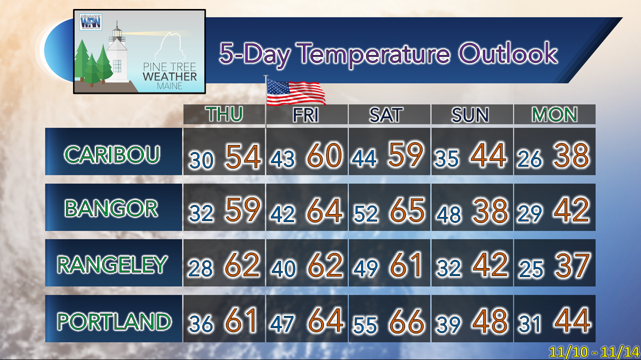 Donations appreciated to keep the lights on for 2023 NOTE: The forecast information depicted on this platform is for general information purposes only for the public and is not designed or intended for commercial use. For those seeking pinpoint weather information for business operations, you should use a private sector source. For information about where to find commercial forecasters to assist your business, please message me and I will be happy to help you |

Mike Haggett
|


