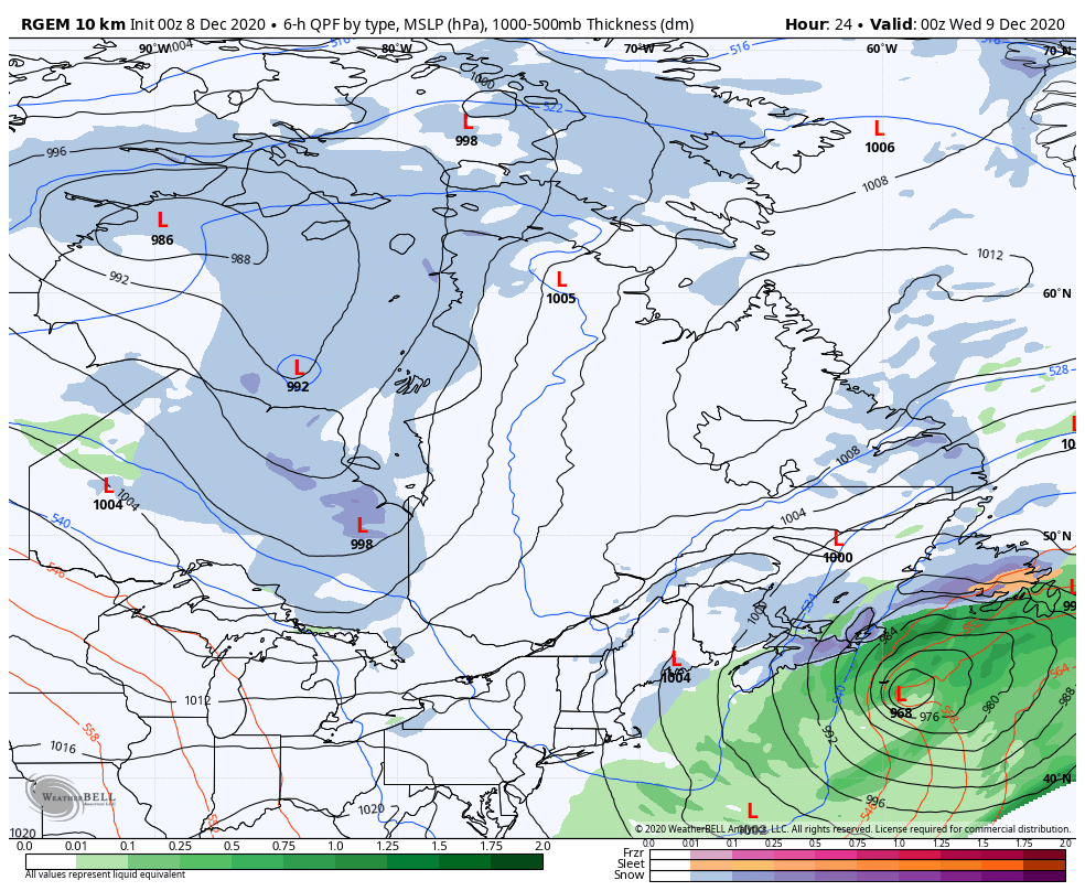
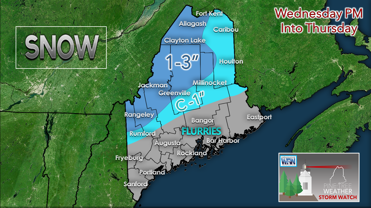
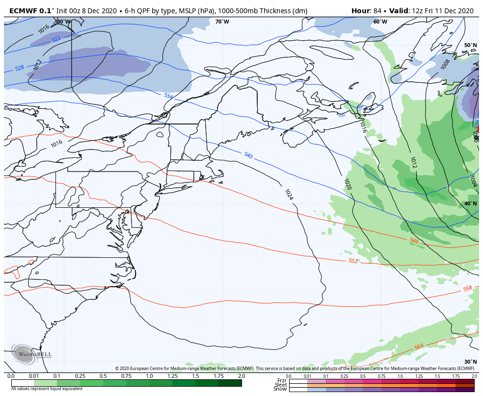
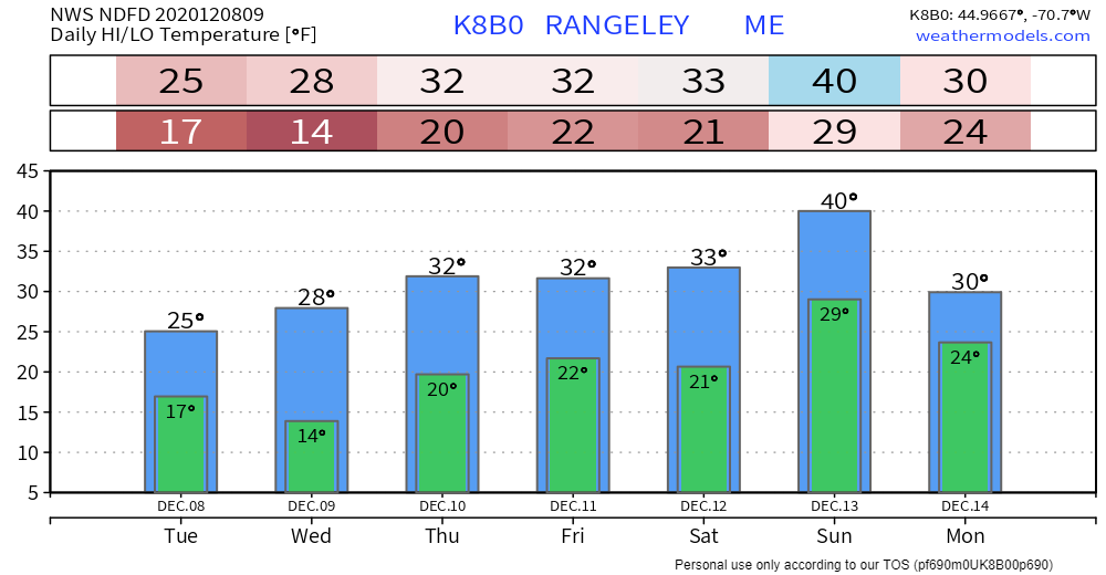
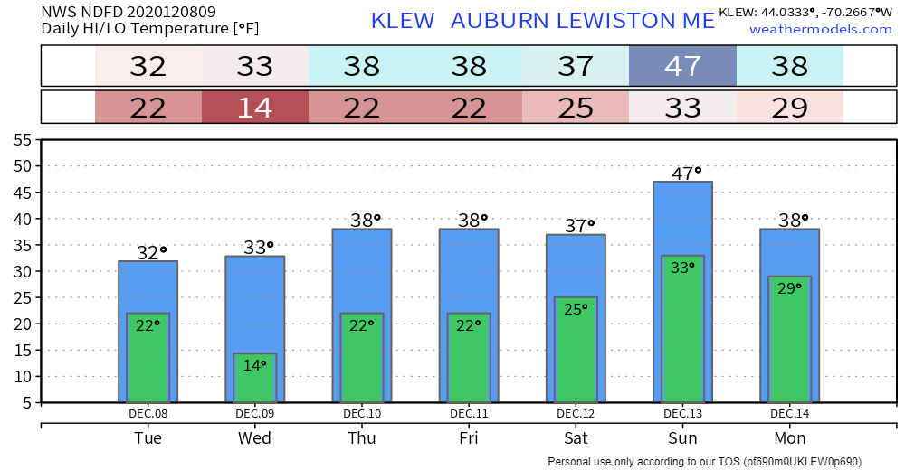
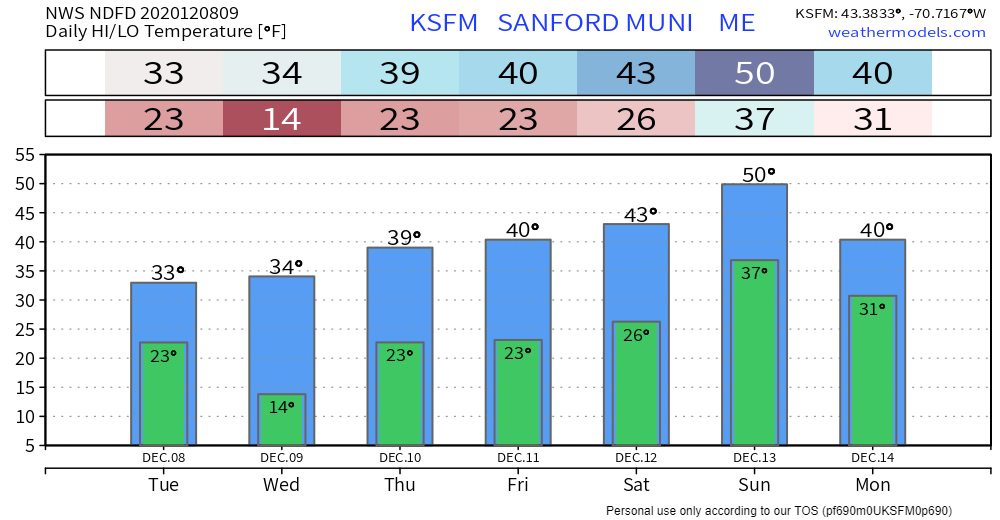
Pine Tree Weather
  • DISCUSSIONS
  • DONATE
  • WEATHER WALL
  • MAPS
  • RAIN OUTLOOK
  • SEVERE
  • MARINE
  • CPC OUTLOOK
  • Kennebunk
  • MY BIO
  • PTW IN MEDIA
  • OBSERVING WEATHER
  • INTERNSHIPS
  • INTERN ALUMNI
  • DISCUSSIONS
  • DONATE
  • WEATHER WALL
  • MAPS
  • RAIN OUTLOOK
  • SEVERE
  • MARINE
  • CPC OUTLOOK
  • Kennebunk
  • MY BIO
  • PTW IN MEDIA
  • OBSERVING WEATHER
  • INTERNSHIPS
  • INTERN ALUMNI

A cloudy Tuesday, some light snow around Wednesday into Thursday

12/8/2020

Comments


A gray cool day

Picture
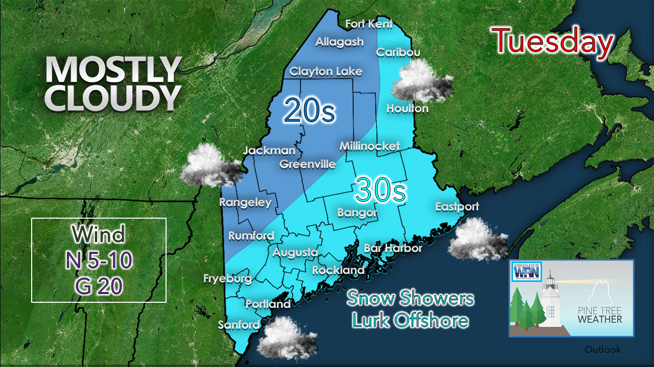
You may want to grab an extra layer if working outside today as it will be breezy enough to add a bit if a snap to the air. Wind chill values will run in single digits to teens north and around 20° south. A storm offshore is tapping into the cold to the north and hauling it into the region. 
Picture
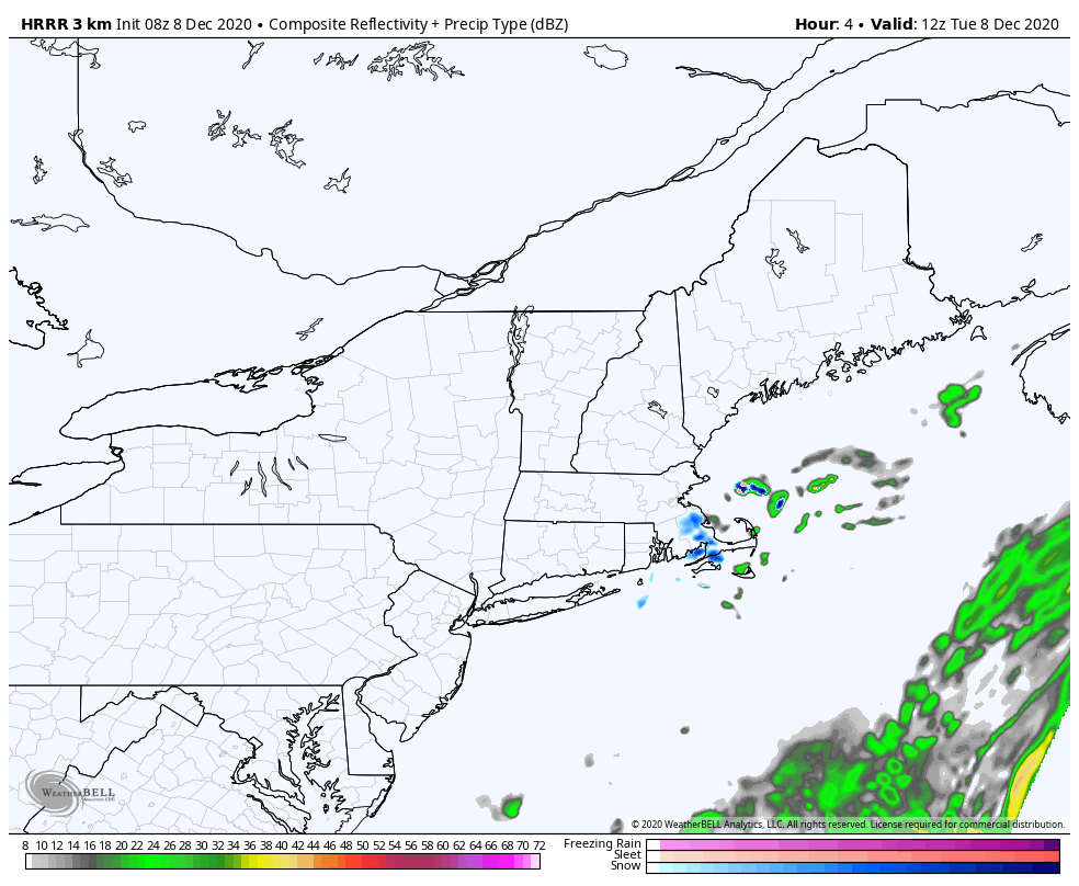
HRRR idea of radar reflectivity from 7 AM - 7 PM Tuesday
I don't expect much in the way of precipitation for the day. Snow showers lurk just offshore from the storm to the southeast. If the storm jogs a bit north, that may bring them to the shorelines. This appears to be a decent ocean effect snow day the south shore of Massachusetts and the Cape. There may be some interesting snow totals from there by the time it wraps up Tuesday night. 

A sneaky inverted trough set up
​Wednesday into Thursday

It's that time of the year where I pay close attentions to disturbances and inversions as they pass through the region. We've had a few surprise clippers and inverted trough set ups over the years. I don't like being caught in dismissing them and have them come back and bite me. 
Picture
RGEM model idea of mean sea level pressure and 3-hour precipitation from 7 PM Tuesday to 7 AM Thursday
Offshore storm departs to the northeast. A fairly strong area of low pressure over the north end of Hudson Bay brings a trough in to the southeast. This appears to create a decent lake effect event northern New York. On the surface, it does not appear to be that big of a deal for Maine. 
Picture
RGEM model idea of 500 mb heights and vorticity from 7 AM Tuesday to 7 AM Thursday
Going away from the surface and opening the hood this shows plenty of upper level energy, which at the very least will bring clouds. This sets up a negatively tilted trough scenario, and appears to fire a storm well offshore late Wednesday and bring Newfoundland a decent event later in the week.

There is enough energy and enough moisture where interior areas could get a couple inches of snow out of it. 
Picture
The only thing I am not confident about at this point is what happens along the coast. Southern areas may pick up some accumulation, perhaps enough to get the road crews out for a quick scrape or salt run. I will keep an eye on it and advise. 

Mixed signals on the weekend

Picture
High pressure works into the region Friday, That is about the only idea models agree on at this point. Timing of the warm front and approaching storm to the west on Saturday is still to be determined. This is simply an idea for now. Stay tuned.

Temperature outlook through Monday

Temperatures are expected to around normal for the north, and below normal for the south during the period. 
Picture
Picture
Picture
Picture
Picture

Picture

Be prepared to receive alerts and stay updated!

Picture
​BE PREPARED WITH A NOAA Weather Radio.

​For $20-$40, it could provide important information to you when you need it. The weather bands are standard on most public safety scanners, and newer scanner models. Weather radios can be programmed for auto alert.  Click here for more information.

► ► For the latest official forecasts, bulletins and advisories, please check in with the National Weather Service in Gray for western and southern areas, or Caribou for northern and eastern parts of Maine
Picture

For more information, please follow Pine Tree Weather on Facebook and Twitter. 

** FUNDING NEEDED FOR 2021 **
​Thank you for supporting this community based weather information source that is funded by your financial contributions. 


Stay updated, stay on alert, and stay safe!

​- Mike
Comments
    Picture

    Mike Haggett
    Kennebunk, ME

    Weather-Ready Nation
    Ambassador

    Certified Weather
    Forecaster
    Penn State '21

    American Meteorological Society

    National Weather Association
    ​
    ​SKYWARN-CWOP

    Matthew 19:26


    DONATE

    Picture
    Picture
    Picture
    Picture
    Picture

    Picture

    Picture

    Picture

    Picture

    Picture

    Picture

    Picture

    Picture

    Picture

    Picture

    Picture

    Picture


    Archives

    April 2025
    March 2025
    February 2025
    January 2025
    December 2024
    November 2024
    October 2024
    September 2024
    August 2024
    July 2024
    June 2024
    May 2024
    April 2024
    March 2024
    February 2024
    January 2024
    December 2023
    November 2023
    October 2023
    September 2023
    August 2023
    July 2023
    June 2023
    May 2023
    April 2023
    March 2023
    February 2023
    January 2023
    December 2022
    November 2022
    October 2022
    September 2022
    August 2022
    July 2022
    June 2022
    May 2022
    April 2022
    March 2022
    February 2022
    January 2022
    December 2021
    November 2021
    October 2021
    September 2021
    August 2021
    July 2021
    June 2021
    May 2021
    April 2021
    March 2021
    February 2021
    January 2021
    December 2020
    November 2020
    October 2020
    September 2020
    August 2020
    July 2020
    June 2020
    May 2020
    April 2020
    March 2020
    February 2020
    January 2020
    December 2019
    November 2019
    October 2019
    September 2019
    August 2019
    July 2019
    June 2019
    May 2019
    April 2019
    March 2019
    February 2019
    January 2019
    December 2018
    November 2018
    October 2018
    September 2018
    August 2018
    July 2018
    June 2018
    May 2018
    April 2018
    March 2018
    February 2018
    January 2018
    December 2017
    November 2017
    October 2017

Proudly powered by Weebly