Pine Tree Weather
  • DISCUSSIONS
  • DONATE
  • MAPS
  • NWS BRIEFINGS
  • SATRAD
  • MARINE
  • SNOW / ICE OUTLOOK
  • RAIN OUTLOOK
  • CPC OUTLOOK
  • Kennebunk
  • OBSERVING WEATHER
  • Who We Are
  • My Photography
  • DISCUSSIONS
  • DONATE
  • MAPS
  • NWS BRIEFINGS
  • SATRAD
  • MARINE
  • SNOW / ICE OUTLOOK
  • RAIN OUTLOOK
  • CPC OUTLOOK
  • Kennebunk
  • OBSERVING WEATHER
  • Who We Are
  • My Photography

A coastal brush for Saturday PM; midweek snow thoughts

1/4/2019

Comments


Down East areas may pick up a bit of snow

Picture
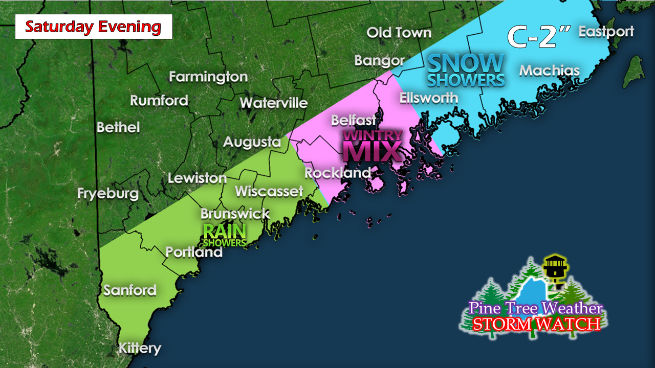
An ocean storm passing to the southeast appears to graze the coastal plain with some precipitation. The timing of the precipitation appears to be mid to late afternoon for the southwest coast and early to mid-evening for DownEast areas. Temperatures are likely to be falling when the precipitation arrives. For southwestern areas, this is a mainly rain event with a chance for some snow showers after dark, with little accumulation. The Penobscot Bay area may see rain switch to snow showers, and perhaps a touch of sleet and/or freezing rain. DownEast areas from Bar Harbor to Eastport could see a coating to a couple inches of snow by the time precipitation ends in the wee hours of Sunday. 

Tuesday / Wednesday likely snowy, but not a big event

Picture
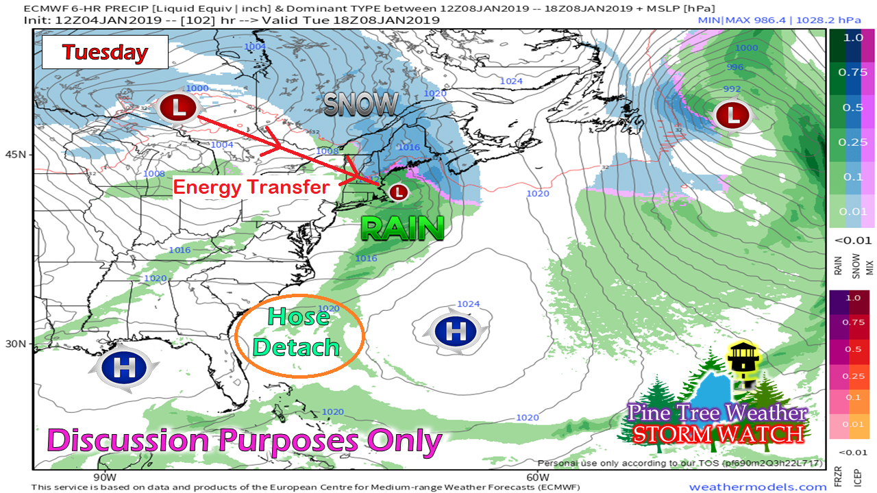
I am backing off the idea of a full on NorEaster, but snow is definitely in the offing for Tuesday and Wednesday next week.  Models have backed off the idea of the intensification of a secondary low forming in the Gulf of Maine. The other issue is moisture. NorEasters depend on a strong moisture stream from the southwest in order to produce copious snow amounts. What moisture (the hose) that gets picked up by the frontal boundary crossing eastward gets cut off thanks to two areas of high pressure to the southeast and southwest. 

For now, I am thinking this is a general 3-6" snowstorm. That said, another tricky inversion may set up and enhance snow totals in Wednesday. 

This is NOT the final answer. Stay tuned. 

Outlook through Wednesday

Picture
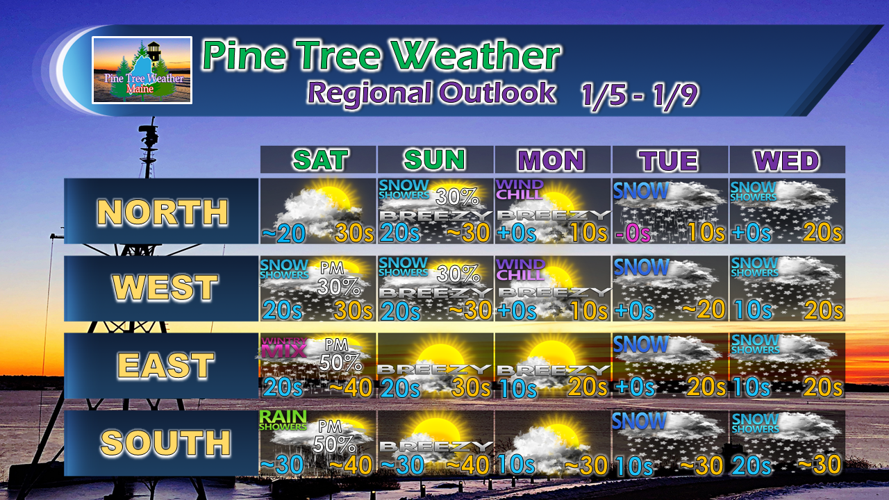
​For the latest official forecasts, bulletins and advisories, please check in with the National Weather Service in Gray for western and southern areas, or Caribou for northern and eastern parts of Maine.

For more information from me, please follow the Pine Tree Weather Facebook page and my Twitter feed.

Your financial donations are much appreciated to keep this site funded and for further development. 

I sincerely appreciate your support.

Always stay weather aware! 

​- Mike
Comments
    Picture

    Mike Haggett
    Kennebunk, ME

    Certified Weather
    Forecaster
    Penn State '21

    American Meteorological Society

    National Weather Association

    Weather-Ready Nation 
    Ambassador
    ​
    ​SKYWARN-CWOP

    Matthew 19:26


    Support
    Pine Tree Weather

    DONATE

    Picture

    Picture

    Picture

    Picture

    Picture

    Picture

    Picture

    Picture

    Picture

    Picture

    Archives

    January 2023
    December 2022
    November 2022
    October 2022
    September 2022
    August 2022
    July 2022
    June 2022
    May 2022
    April 2022
    March 2022
    February 2022
    January 2022
    December 2021
    November 2021
    October 2021
    September 2021
    August 2021
    July 2021
    June 2021
    May 2021
    April 2021
    March 2021
    February 2021
    January 2021
    December 2020
    November 2020
    October 2020
    September 2020
    August 2020
    July 2020
    June 2020
    May 2020
    April 2020
    March 2020
    February 2020
    January 2020
    December 2019
    November 2019
    October 2019
    September 2019
    August 2019
    July 2019
    June 2019
    May 2019
    April 2019
    March 2019
    February 2019
    January 2019
    December 2018
    November 2018
    October 2018
    September 2018
    August 2018
    July 2018
    June 2018
    May 2018
    April 2018
    March 2018
    February 2018
    January 2018
    December 2017
    November 2017
    October 2017

    RSS Feed

Proudly powered by Weebly