Pine Tree Weather
  • DISCUSSIONS
  • DONATE
  • WEATHER WALL
  • MAPS
  • RAIN OUTLOOK
  • SEVERE
  • MARINE
  • CPC OUTLOOK
  • Kennebunk
  • MY BIO
  • PTW IN MEDIA
  • OBSERVING WEATHER
  • INTERNSHIPS
  • INTERN ALUMNI
  • DISCUSSIONS
  • DONATE
  • WEATHER WALL
  • MAPS
  • RAIN OUTLOOK
  • SEVERE
  • MARINE
  • CPC OUTLOOK
  • Kennebunk
  • MY BIO
  • PTW IN MEDIA
  • OBSERVING WEATHER
  • INTERNSHIPS
  • INTERN ALUMNI

A coastal chance for rain Friday; NorEaster with snow potential Sunday into Monday

4/24/2020

Comments


A close shave of rain Friday

Picture
Low pressure responsible for the recent round of severe weather in the south moves out to sea off the MidAtlantic coast for Friday. With the dry air around from high pressure of Thursday, what rain drops fall may get evaporated before reaching the surface away from the shorelines. The best chance of any rain accumulation appears for southern York County and it may not be more than a couple hundreths of an inch. 

Northern areas take a pass on this event and enjoy a mostly sunny sky for the day. Varying amounts of clouds are expected over western and interior eastern areas.  The shorelines appear to stay in the clouds through Friday evening.

High temperatures range from the mid-40s to mid-50s. The wind will generally be light away from the coast. The shorelines may see a breeze in the 5-15 mph range from the northeast this afternoon. 

Friday night, the sky clears out, and the breeze kicks up out of the north / northwest at 5-15 mph with gusts around 20 mph. Overnight lows to start Saturday range in the teens for the mountains, 20s for areas away from the coast to around 30° along the shorelines.

Saturday feels like spring. Sunshine and 50s for most, with interior southwestern areas reaching into the low 60s. An onshore breeze in the afternoon keeps the shorelines in the low 50s. 

Tracking a NorEaster to start the week

Picture
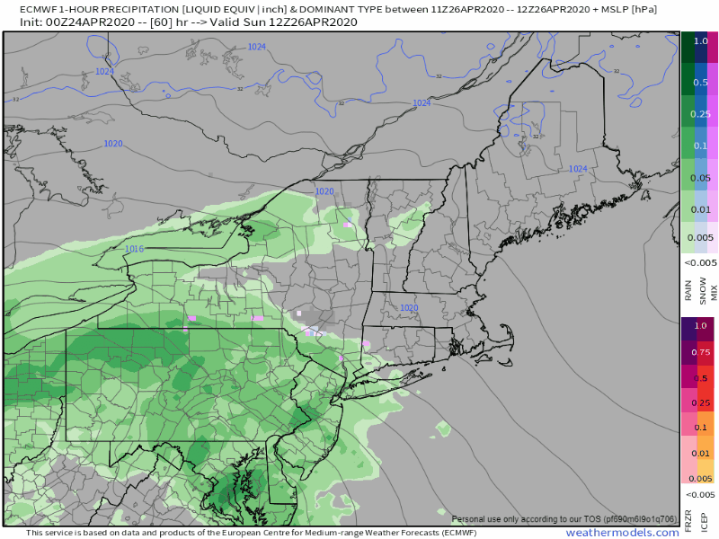
I've mentioned at times over the past couple of weeks that this pattern we are in is rather typical for mid-winter. Case in point is the loop depicted above. A classic Miller-B NorEaster. Low pressure center around the benchmark 40°N / 70°W point. Plenty of moisture to work with, and cold air around. If this were January, and air colder, this would be a 12-18" snow event. Given that is it late April, the rough idea for this one is 2-5" of wet slop for interior areas. The key at this point is figuring intensification. The storm will be developing as it approaches the Gulf of Maine. With the wet snow, add wind to that, and we're talking potential power outages. It may not be a bad idea to make sure your supplies are where they need to be, just in case.

Stay tuned for updates.

​Help the weather community and stay informed!

Picture
YOUR HELP IS NEEDED STATEWIDE!

Virtual SKYWARN training sessions are upcoming! For more information and to regisiter, check the NWS Gray Office for western and southern areas, and the NWS Caribou Office for eastern and northern areas.

Picture
With the recent loss of power, internet and cell phone disruption, it would be wise to consider a small investment into an NOAA Weather Radio.

​For $20-$40, it could provide important information to you when you need it. The weather bands are standard on most public safety scanners, and newer scanner models and weather radios can be programmed for auto alert.  
Click here for more information. ​

​► ► For the latest official forecasts, bulletins and advisories, please check in with the National Weather Service in Gray for western and southern areas, or Caribou for northern and eastern parts of Maine.

Thanks as always for your support!

​- Mike
Comments
    Picture

    Mike Haggett
    Kennebunk, ME

    Weather-Ready Nation
    Ambassador

    Certified Weather
    Forecaster
    Penn State '21

    American Meteorological Society

    National Weather Association
    ​
    ​SKYWARN-CWOP

    Matthew 19:26


    DONATE

    Picture
    Picture
    Picture
    Picture
    Picture

    Picture

    Picture

    Picture

    Picture

    Picture

    Picture

    Picture

    Picture

    Picture

    Picture

    Picture

    Picture


    Archives

    April 2025
    March 2025
    February 2025
    January 2025
    December 2024
    November 2024
    October 2024
    September 2024
    August 2024
    July 2024
    June 2024
    May 2024
    April 2024
    March 2024
    February 2024
    January 2024
    December 2023
    November 2023
    October 2023
    September 2023
    August 2023
    July 2023
    June 2023
    May 2023
    April 2023
    March 2023
    February 2023
    January 2023
    December 2022
    November 2022
    October 2022
    September 2022
    August 2022
    July 2022
    June 2022
    May 2022
    April 2022
    March 2022
    February 2022
    January 2022
    December 2021
    November 2021
    October 2021
    September 2021
    August 2021
    July 2021
    June 2021
    May 2021
    April 2021
    March 2021
    February 2021
    January 2021
    December 2020
    November 2020
    October 2020
    September 2020
    August 2020
    July 2020
    June 2020
    May 2020
    April 2020
    March 2020
    February 2020
    January 2020
    December 2019
    November 2019
    October 2019
    September 2019
    August 2019
    July 2019
    June 2019
    May 2019
    April 2019
    March 2019
    February 2019
    January 2019
    December 2018
    November 2018
    October 2018
    September 2018
    August 2018
    July 2018
    June 2018
    May 2018
    April 2018
    March 2018
    February 2018
    January 2018
    December 2017
    November 2017
    October 2017

Proudly powered by Weebly