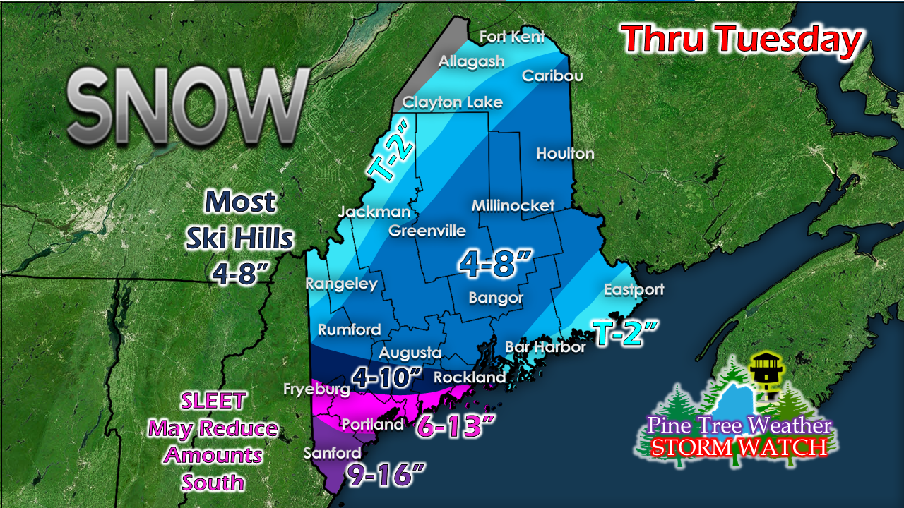
Pine Tree Weather
  • DISCUSSIONS
  • DONATE
  • WEATHER WALL
  • MAPS
  • RAIN OUTLOOK
  • SEVERE
  • MARINE
  • CPC OUTLOOK
  • Kennebunk
  • MY BIO
  • PTW IN MEDIA
  • OBSERVING WEATHER
  • INTERNSHIPS
  • INTERN ALUMNI
  • DISCUSSIONS
  • DONATE
  • WEATHER WALL
  • MAPS
  • RAIN OUTLOOK
  • SEVERE
  • MARINE
  • CPC OUTLOOK
  • Kennebunk
  • MY BIO
  • PTW IN MEDIA
  • OBSERVING WEATHER
  • INTERNSHIPS
  • INTERN ALUMNI

A complicated storm to potentially bring a messy start to the week for Maine

12/1/2019

Comments


Still a tough forecast

Picture
For southern areas, this appears to be roughly a 48 hour event. For most of the rest of the region it appears to be 24-30 hour event. Bust potential still looms large in many facets of the forecast, especially the Tuesday part. I'll give it my best shot here, but confidence is low. 

Stage one: Sunday to Monday 7 PM

Picture
The storm will be slower in arrival, so for those folks hanging on for an extra day of family time before you head home, you lucked out. Conditions will go downhill over western New England this afternoon. The first wave of flakes should arrive in southern Maine by around early evening.

The storm stalls and spins east of the benchmark 40°/ 70° through the day on Monday. Dry air to the north shuts out ski country and the north. High pressure associated with that dry air keeps precipitation confined to southern areas from roughly Fryeburg to Rockland south through early Monday evening.
Picture
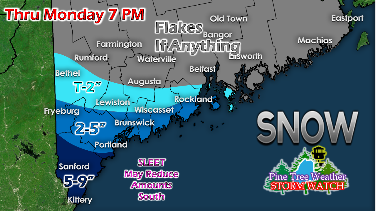
The heavier amounts of snow are to be in York County. Due to the stalling of the storm, I remain concerned that warm air will sneak in aloft and form a TROWAL (TRough Of Warm air ALoft) and bring the threat for sleet. There is always the chance for a coastal front to develop, but the strong northeast wind may limit that chance to the islands and immediate shorelines. Add the wind that could gust 20-30+ mph, all the ingredients will make for tough travel in the most populated region of the state. 

Stage two: Monday 7 PM to end of storm

Picture
So this is where the forecast gets real complicated. I've mentioned previously issues with the lack of stacking between the surface low, mid-level lows and the upper low which is causing the conundrum of mixed forecast ideas as a result of various model solutions. Where the atmosphere may pull together appears early Tuesday. As the upper low moves into capture the surface low, an new surface low forms and then potentially heads north in the Gulf of Maine towards DownEast areas before moving east. 

With that idea, this is where the rest of the state gets in on the precipitation, and will potentially cause issues with the morning and evening commutes for Bangor and points north and west. 

The storm departs and precipitation shuts down Tuesday night. Strong wind may cause blowing an drifting of snow, and potentially some power outages. 
Picture
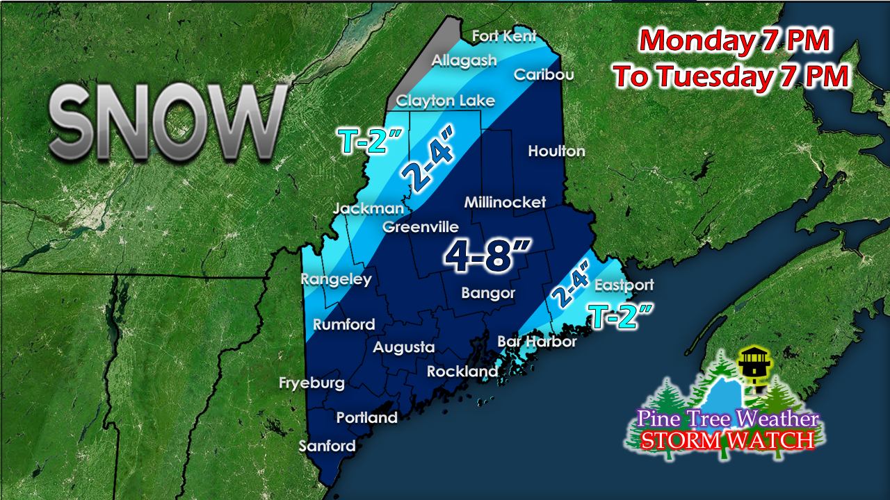
Day two of the storm brings additional accumulations to southern areas, and brings most of the rest of the state a decent amount of snow through Tuesday evening.

An uncharacteristic snow total
​for an uncharacteristic storm

Picture
Add Monday and Tuesday totals together and this is the end result. It's crazy, but it's not out of the realm of possibility. 

Stay tuned.

​► ► For the latest official forecasts, bulletins and advisories, please check in with the National Weather Service in Gray for western and southern areas, or Caribou for northern and eastern parts of Maine.

Please consider Pine Tree Weather in holiday giving! 

Picture
​► ► $620 shortfall for the year ahead! You can help keep Pine Tree Weather going with a donation of any amount now through VENMO @PineTreeWeather, a monthly donation on Patreon or messaging me on Facebook or Twitter to send a check in the mail. Thank you for your support!

For more information from me, please check the Pine Tree Weather Facebook page as well as my Twitter feed. 

Always stay weather aware!

​- Mike
Comments
    Picture

    Mike Haggett
    Kennebunk, ME

    Weather-Ready Nation
    Ambassador

    Certified Weather
    Forecaster
    Penn State '21

    American Meteorological Society

    National Weather Association
    ​
    ​SKYWARN-CWOP

    Matthew 19:26


    DONATE

    Picture
    Picture
    Picture
    Picture
    Picture

    Picture

    Picture

    Picture

    Picture

    Picture

    Picture

    Picture

    Picture

    Picture

    Picture

    Picture

    Picture


    Archives

    May 2025
    April 2025
    March 2025
    February 2025
    January 2025
    December 2024
    November 2024
    October 2024
    September 2024
    August 2024
    July 2024
    June 2024
    May 2024
    April 2024
    March 2024
    February 2024
    January 2024
    December 2023
    November 2023
    October 2023
    September 2023
    August 2023
    July 2023
    June 2023
    May 2023
    April 2023
    March 2023
    February 2023
    January 2023
    December 2022
    November 2022
    October 2022
    September 2022
    August 2022
    July 2022
    June 2022
    May 2022
    April 2022
    March 2022
    February 2022
    January 2022
    December 2021
    November 2021
    October 2021
    September 2021
    August 2021
    July 2021
    June 2021
    May 2021
    April 2021
    March 2021
    February 2021
    January 2021
    December 2020
    November 2020
    October 2020
    September 2020
    August 2020
    July 2020
    June 2020
    May 2020
    April 2020
    March 2020
    February 2020
    January 2020
    December 2019
    November 2019
    October 2019
    September 2019
    August 2019
    July 2019
    June 2019
    May 2019
    April 2019
    March 2019
    February 2019
    January 2019
    December 2018
    November 2018
    October 2018
    September 2018
    August 2018
    July 2018
    June 2018
    May 2018
    April 2018
    March 2018
    February 2018
    January 2018
    December 2017
    November 2017
    October 2017

Proudly powered by Weebly