Pine Tree Weather
  • DISCUSSIONS
  • DONATE
  • MAPS
  • NWS BRIEFINGS
  • SATRAD
  • MARINE
  • SNOW / ICE OUTLOOK
  • RAIN OUTLOOK
  • CPC OUTLOOK
  • Kennebunk
  • OBSERVING WEATHER
  • Who We Are
  • My Photography
  • DISCUSSIONS
  • DONATE
  • MAPS
  • NWS BRIEFINGS
  • SATRAD
  • MARINE
  • SNOW / ICE OUTLOOK
  • RAIN OUTLOOK
  • CPC OUTLOOK
  • Kennebunk
  • OBSERVING WEATHER
  • Who We Are
  • My Photography

A damp and windy end to the week

2/16/2022

Comments

 
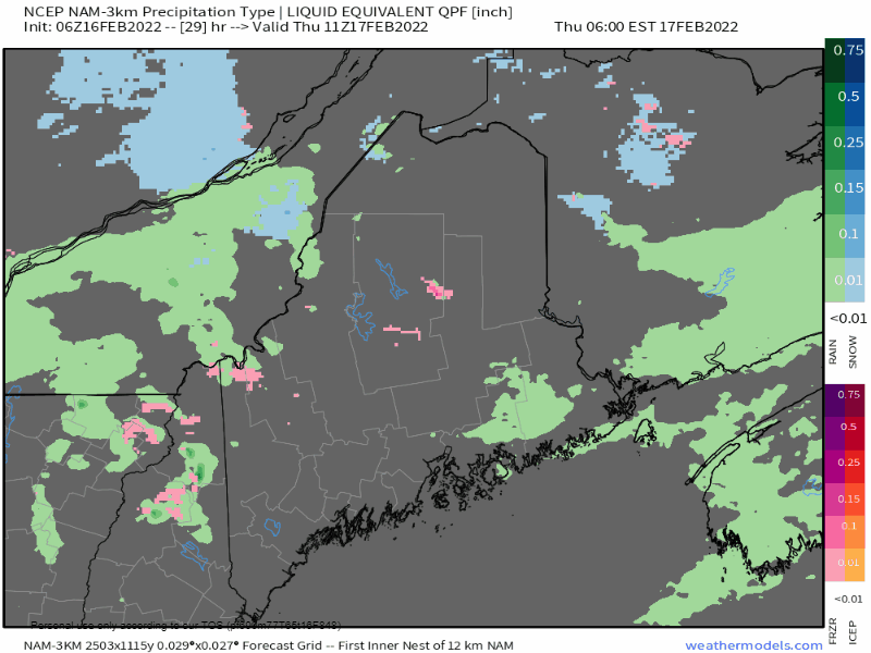
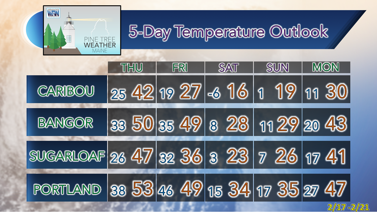
I am getting back into the groove here after a week-long break that was unanticipated to deal with some personal matters. I am grateful the pattern has been relatively quiet as I also used the time to recharge my batteries a bit. I am working hard in several ways to keep up with the demands of everything between my day job, father, husband, and my recovery. It gets to be a bit much at times. While I thoroughly enjoy forecasting weather and sharing my thoughts with you folks, it does take a toll on me. Time management is always a challenge. I have to be rational about my efforts here. The day will come where this will be more of a full-time operation, but for now I will focus primarily on storms and impacts. I will update as often as I can, whether here, on Twitter or Facebook. I've had your back for ten years now, and I plan to keep it. I appreciate your support more than you know, and thank you for understanding. 

Ridge begins to build Wednesday

Picture
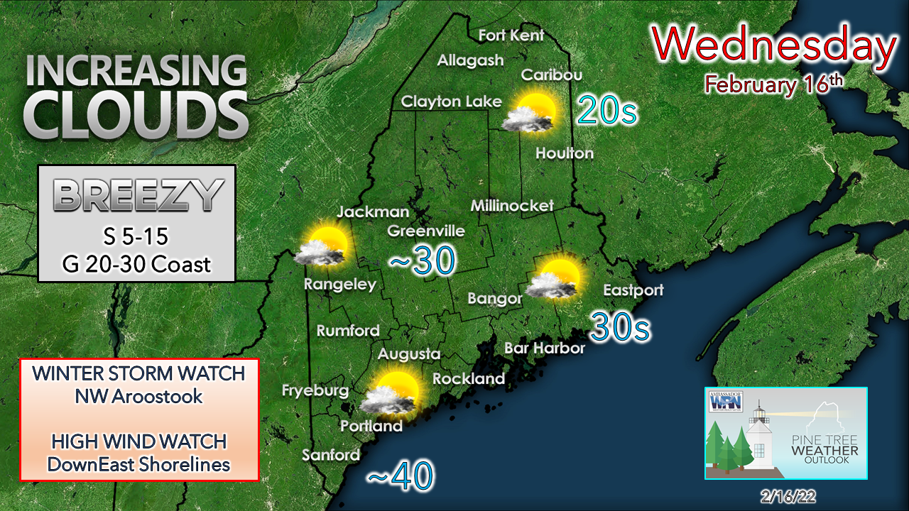
After another bone chilling start over the region, temperatures begin to increase. High pressure responsible for the cold shifts east, and a southerly flow develops. Coastal areas experience a stiff breeze as the day evolves, along with the higher hills. Clouds increase as a strong upper-level ridge moves in from the southwest. The breeze continues into Wednesday night, and expect it to continue through the remainder of the week. 

Long wave frontal boundary to bring rain, wind,
​and snow to the far north Thursday into Friday

Picture
Thursday 7 AM to Friday 1 PM - If this movie looks familiar to you, it should as it is similar to what was experienced last week, but warmer. These long wave boundaries are a sign of the change of seasons as we are in mid-February, the 2021-22 meteorological winter is on its final stretch drive in the next two weeks.   
Picture
Thursday 7 AM to Friday 1 PM - With the long wave frontal boundary comes a surge of moisture from the Gulf of Mexico. Precipitable water values in the 200-400% above the typical average are in the offing here. This is something more typical in late spring than in mid-February. 
Picture
Wednesday 7 PM to Friday Noon- With the increase of moisture sends dew point temperatures surging above freezing across the state by around midday Thursday. This is a key component as this will ripen the snowpack for melting. With the higher dew points comes fog, which is the primary melt mechanism of the snow more so than rain. There is roughly a 24-hour window here with the dew points above freezing before the frontal boundary moves east and brings the cold air in to stop the melt. Fog could be locally dense in areas, even with breezy conditions. 
Picture
Thursday 6 AM to Friday 1 PM- Rain showers appear likely for the mountains and north Thursday with coastal areas staying mainly dry, outside of patchy drizzle and fog. The front moves in Thursday night and increases precipitation statewide and clears the coast by Friday morning. By noon Friday, precipitation ends, a breezy northwest wind hauls cold air back in, and clears the sky. 
Picture
Northern areas and the western mountains are likely to see the most precipitation from this event. Upslope rains could drive rainfall amounts over 1" for the ski hills. Add the dew points above freezing, the snowpack will take a hit. The good news for snow lovers is the window is narrow and with the cold air working in immediately behind the front on Friday, which ends the melting during this cycle. Expect whatever liquid to freeze up Friday afternoon statewide. This may bring a few slick spots in areas. Given the short window, rivers may rise with some runoff, but overall, the flood risk is low. 
Picture
Strong southwesterly wind is the main impact of concern for the shorelines. A High Wind Watch has been posted for the DownEast shorelines where gusts to 60 mph are possible. The higher elevations in the western mountains along with the immediate southwest coastal shorelines may see gusts 40-50 mph. Open areas in between see gusts mainly in the 30s. The threat for power outages is highest along the shorelines, with MidCoast and DownEast coastal areas with the greatest risk. 
Picture
As far as snow goes, northwestern Aroostook appears to stay in the cold long enough to get the higher amounts. Western and eastern areas may see some snow shower activity as a parting gift Friday morning as the boundary moves eastward. 

Picture

Temperature outlook through Monday

After a surge in temperatures on Thursday, high temperatures are established in the wee hours of Friday and fall during the day. Snow showers with light accumulation are possible statewide for Saturday. After a weekend of temperatures near normal, temperatures head northward once again to start the week, with another potential longwave system to bring a mixed bag of precipitation Tuesday into Wednesday. 
Picture

Driving in Dense Fog

Picture
​If fog reduces your visibility while driving, do not change lanes or pass other vehicles unless absolutely necessary. Be sure that you can stop within the distance that you can see. weather.gov/safety/fog

​Be prepared to receive alerts and stay updated!

Picture
​BE PREPARED WITH NOAA Weather Radio.
​​
​For $20-$40, it could provide vital information to you when you need it. The weather bands are standard on most public safety scanners, and newer scanner models. Weather radios can be programmed for auto alert. Click here for more information.

​​► ► For the latest official forecasts, bulletins, and advisories, please check in with the National Weather Service in Gray for western and southern areas, or Caribou for northern and eastern parts of Maine.
Picture

Picture
For more information in between posts, please follow Pine Tree Weather on Facebook and Twitter. 

​Thank you for supporting this community-based weather information source which operates by reader supported financial contributions. 

Thank you as always for your support! 

- Mike

​NOTE: The forecast information depicted on this platform is for general information purposes only for the public and is not designed or intended for commercial use. For those seeking pinpoint weather information for business operations should use a private sector source. For information about where to find commercial forecasters to assist your business, please message me and I will be happy to help you.

Comments
    Picture

    Mike Haggett
    Kennebunk, ME

    Certified Weather
    Forecaster
    Penn State '21

    American Meteorological Society

    National Weather Association

    Weather-Ready Nation 
    Ambassador
    ​
    ​SKYWARN-CWOP

    Matthew 19:26


    Support
    Pine Tree Weather

    DONATE

    Picture

    Picture

    Picture

    Picture

    Picture

    Picture

    Picture

    Picture

    Picture

    Picture

    Archives

    January 2023
    December 2022
    November 2022
    October 2022
    September 2022
    August 2022
    July 2022
    June 2022
    May 2022
    April 2022
    March 2022
    February 2022
    January 2022
    December 2021
    November 2021
    October 2021
    September 2021
    August 2021
    July 2021
    June 2021
    May 2021
    April 2021
    March 2021
    February 2021
    January 2021
    December 2020
    November 2020
    October 2020
    September 2020
    August 2020
    July 2020
    June 2020
    May 2020
    April 2020
    March 2020
    February 2020
    January 2020
    December 2019
    November 2019
    October 2019
    September 2019
    August 2019
    July 2019
    June 2019
    May 2019
    April 2019
    March 2019
    February 2019
    January 2019
    December 2018
    November 2018
    October 2018
    September 2018
    August 2018
    July 2018
    June 2018
    May 2018
    April 2018
    March 2018
    February 2018
    January 2018
    December 2017
    November 2017
    October 2017

    RSS Feed

Proudly powered by Weebly