Pine Tree Weather
  • DISCUSSIONS
  • DONATE
  • WEATHER WALL
  • MAPS
  • RAIN OUTLOOK
  • SEVERE
  • MARINE
  • CPC OUTLOOK
  • Kennebunk
  • MY BIO
  • PTW IN MEDIA
  • OBSERVING WEATHER
  • INTERNSHIPS
  • INTERN ALUMNI
  • DISCUSSIONS
  • DONATE
  • WEATHER WALL
  • MAPS
  • RAIN OUTLOOK
  • SEVERE
  • MARINE
  • CPC OUTLOOK
  • Kennebunk
  • MY BIO
  • PTW IN MEDIA
  • OBSERVING WEATHER
  • INTERNSHIPS
  • INTERN ALUMNI

A dry start to the week; severe storm potential Wednesday

9/13/2021

Comments


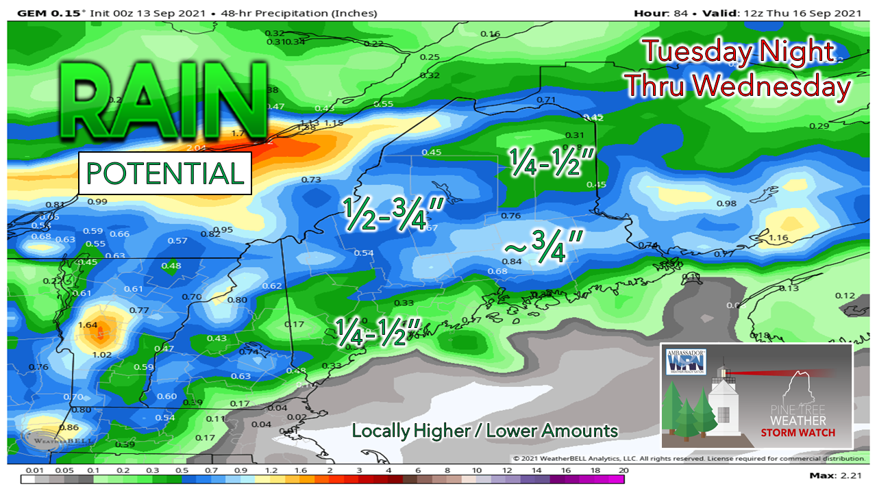
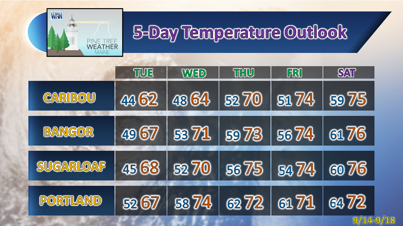
A fair late summer day

Picture
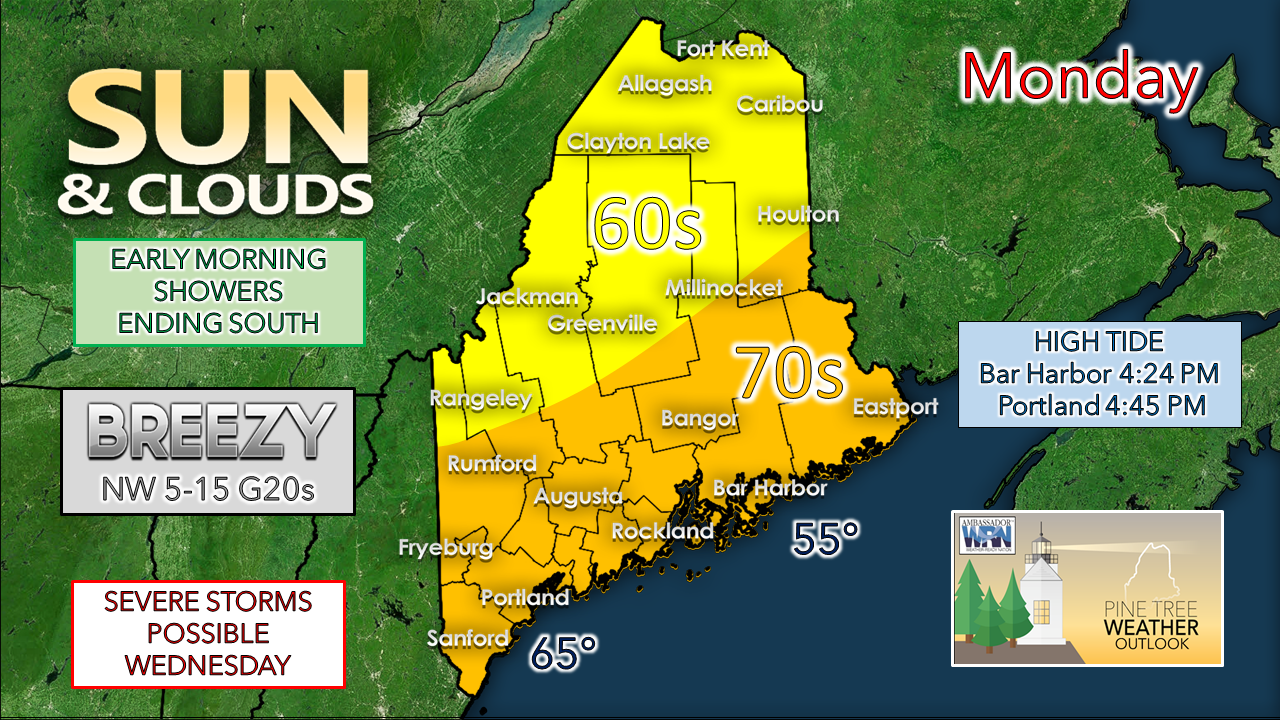
Any early morning showers around to start Monday clear out by mid-morning. A stalled frontal boundary over southern New England drops south, which clears the sky out. High pressure moves in and brings dry air and breezy conditions to the region through this afternoon. 

Any clouds around dissipate after sunset, bringing a clear, cool night ahead. 

Tuesday looks like another pleasant day, a bit cooler than Monday with highs topping out in the 60s for most. Clouds increase in the afternoon as high-pressure slides east and a warm front approaches the region from the southwest. A southerly breeze develops in the afternoon, keeping the shorelines on the cool side. 

Showers Tuesday night,
severe weather possible in areas for Wednesday

Picture
Tuesday night a warm front moves in from the southwest and may bring scattered showers in areas along with it and increases dew point temperatures over southern areas Tuesday night, and to the rest of the state on Wednesday. Showers and the threat for storms increase Wednesday afternoon as a cold front approaches from the northwest.
Picture
The Storm Prediction Center's Day 3 outlook indicates a slight risk for severe storms for southern, western and eastern areas of the state.  Potential for downpours, frequent lightning, damaging wind, hail and an isolated tornado exists through Wednesday afternoon.
Picture
The forecast idea for convective available potential energy shows enough juice for severe storms for southwestern areas. It is important to note that the amount of sun Wednesday is likely to be an indicator of how much of a severe weather threat is generated. The more sun, the greater the potential; more clouds, the better the chance for a bust. 
Picture
Conservative estimates of total rain from the event shows roughly ¼-¾" possible across much of the region, with higher amounts likely in thunderstorms. 

Picture

​Understanding Severe Weather Outlooks

Picture
Do you know the risk categories for severe weather? Learn the severe weather outlooks issued by the Storm Prediction Center spc.noaa.gov

Outlook & temperatures through Saturday

High pressure to the north keeps the state dry for Thursday. Friday and Saturday are a bit of a toss-up at this point pending on remnant of tropical storm Nicholas along with another tropical wave moving northeast late week. Safe to say there is a chance for rain to end the week, and to start the weekend. Updates on that to come. 

After a cool Tuesday, above normal temperatures are likely to be the rule from Wednesday onward into the weekend. 
Picture

Be prepared to receive alerts and stay updated!

Picture
​​BE PREPARED WITH A NOAA Weather Radio.
​
​For $20-$40, it could provide vital information to you when you need it. The weather bands are standard on most public safety scanners, and newer scanner models. Weather radios can be programmed for auto alert. Click here for more information.

​► ► For the latest official forecasts, bulletins, and advisories, please check in with the National Weather Service in Gray for western and southern areas, or Caribou for northern and eastern parts of Maine.
Picture

For more information in between posts, please follow Pine Tree Weather on Facebook and Twitter. 

​Thank you for supporting this community-based weather information source which operates by reader supported financial contributions. 

Stay updated, stay on alert, and stay safe!

​- Mike
Comments
    Picture

    Mike Haggett
    Kennebunk, ME

    Weather-Ready Nation
    Ambassador

    Certified Weather
    Forecaster
    Penn State '21

    American Meteorological Society

    National Weather Association
    ​
    ​SKYWARN-CWOP

    Matthew 19:26


    DONATE

    Picture
    Picture
    Picture
    Picture
    Picture

    Picture

    Picture

    Picture

    Picture

    Picture

    Picture

    Picture

    Picture

    Picture

    Picture

    Picture

    Picture


    Archives

    April 2025
    March 2025
    February 2025
    January 2025
    December 2024
    November 2024
    October 2024
    September 2024
    August 2024
    July 2024
    June 2024
    May 2024
    April 2024
    March 2024
    February 2024
    January 2024
    December 2023
    November 2023
    October 2023
    September 2023
    August 2023
    July 2023
    June 2023
    May 2023
    April 2023
    March 2023
    February 2023
    January 2023
    December 2022
    November 2022
    October 2022
    September 2022
    August 2022
    July 2022
    June 2022
    May 2022
    April 2022
    March 2022
    February 2022
    January 2022
    December 2021
    November 2021
    October 2021
    September 2021
    August 2021
    July 2021
    June 2021
    May 2021
    April 2021
    March 2021
    February 2021
    January 2021
    December 2020
    November 2020
    October 2020
    September 2020
    August 2020
    July 2020
    June 2020
    May 2020
    April 2020
    March 2020
    February 2020
    January 2020
    December 2019
    November 2019
    October 2019
    September 2019
    August 2019
    July 2019
    June 2019
    May 2019
    April 2019
    March 2019
    February 2019
    January 2019
    December 2018
    November 2018
    October 2018
    September 2018
    August 2018
    July 2018
    June 2018
    May 2018
    April 2018
    March 2018
    February 2018
    January 2018
    December 2017
    November 2017
    October 2017

Proudly powered by Weebly