One more shot of mild air before cooler times come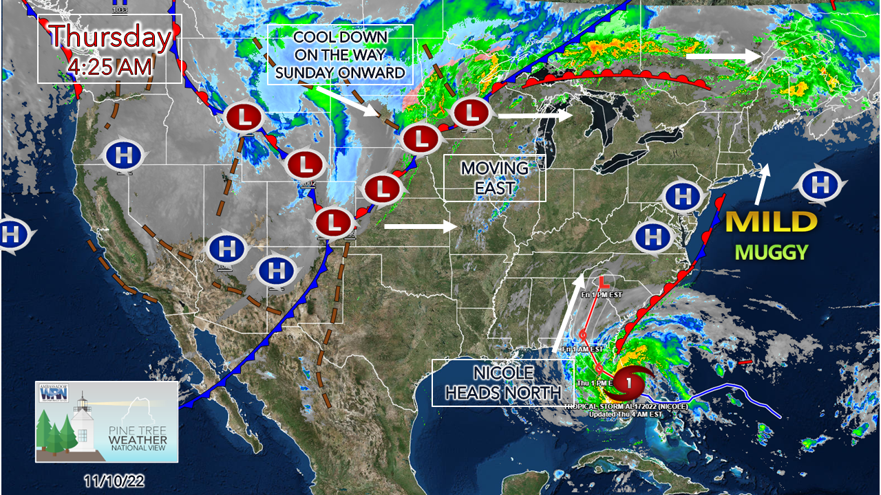 This wacky moderate La Niña pattern that has brought abnormally warm conditions to Maine in similar fashion to November 2020 is about to do a flip-flop. Temperatures trend well above normal through Saturday. After what remains of Nicole and the approaching cold front from the west passes through, below normal temperatures are on the way for next week. It was nice to take a break from the use of heat while it lasted. 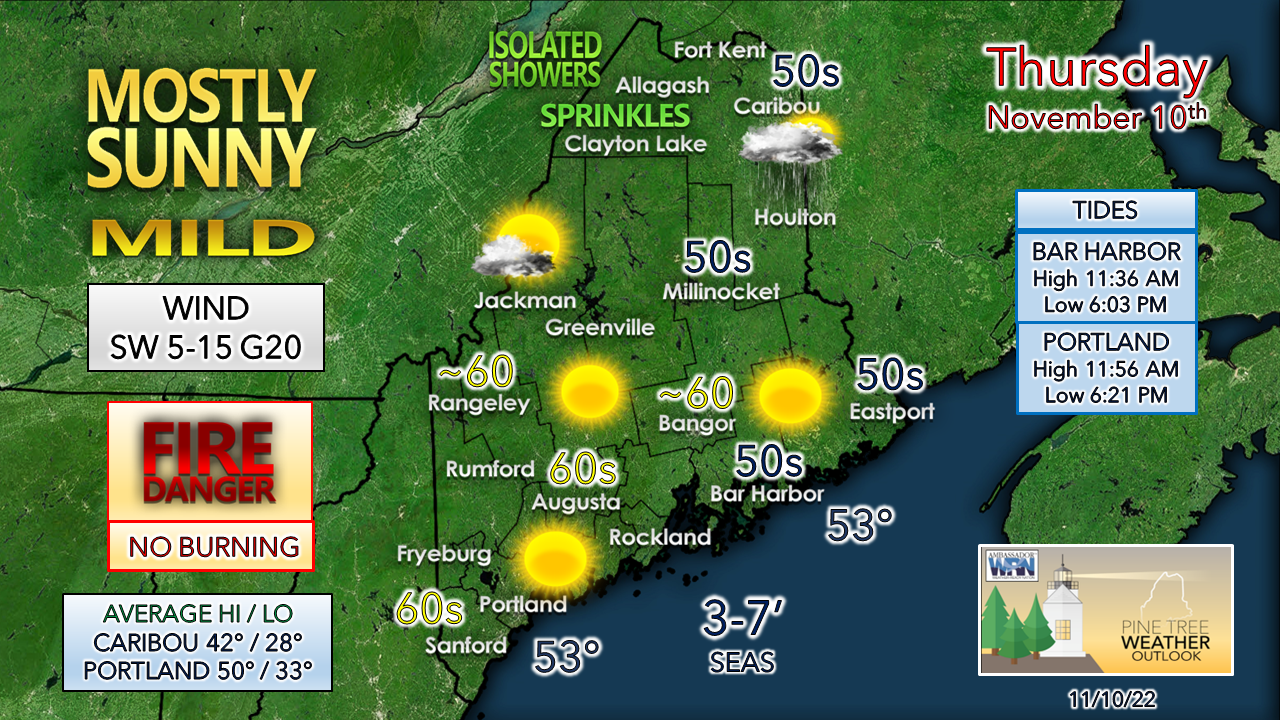 An upper-level ridge brings a few showers to the rooftop of the state while the rest of the region enjoys a mainly sun filled sky and warmer temperatures. The breeze from the southwest increases with an area of high pressure to the southeast and that raises both the mercury and dew point levels. With the breeze and dry leaves, it would be best to not to burn any brush. An elevated fire risk has been posted for the western mountains. Friday / Saturday coming into better focus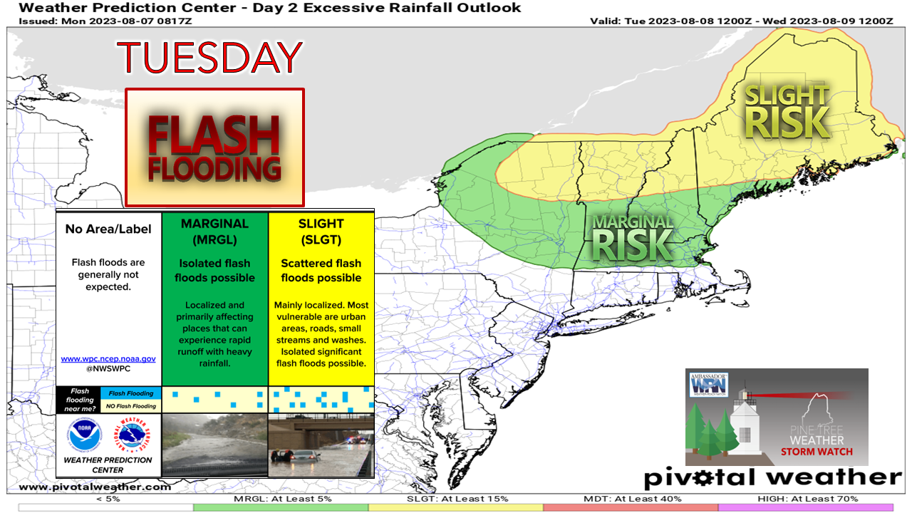 The thing with tropical systems is that the convective (thunderstorm) properties can bring torrential rainfall in areas. While the heaviest precipitation amounts are expected to be north and west along the St. Lawrence River, a strong south / southwest wind pumps additional moisture in off the ocean. The bottom line here is some areas will deal with a lot of rain in a short period of time, with rainfall rates 1-3" / hour if not higher than that. Add the wind blowing leaves around, clogged storm drains are the main threat for the urban areas. Rural areas, especially in the mountains, could get enhanced rainfall from orographic lift which could cause flash flooding in the valleys and streams from runoff there. Confidence is good that the Swift River in West Roxbury may reach flood stage, and areas around the Carrabassett River will need to be monitored as well.  Friday 1 PM to Saturday 7 PM - Rainfall appears to come in two stages. The main concern is for the first wave as that is the remnant moisture from Nicole that moves into southwestern areas Friday afternoon, then expands northwestward Friday night. A break is expected to occur early Saturday morning. As the frontal boundary approaches from the west, an intensifying area of low pressure is expected to form as it progresses through the state onward into the Canadian Maritimes. This brings the next round of rainfall during the day Saturday. Western and southern areas may see some sun break out later in the afternoon as the storm moves out to the northeast before sunset. The remaining steady rainfall ends for northern and eastern areas early Saturday evening. Some upslope showers are possible over the western mountains on Saturday night. There is a risk of thunderstorms associated with this system. With that comes the risk of damaging downdraft wind. The atmosphere will be spinning like a top, so there is potential for an isolated tornado as well. Please have a way to receive alerts and take action when necessary. 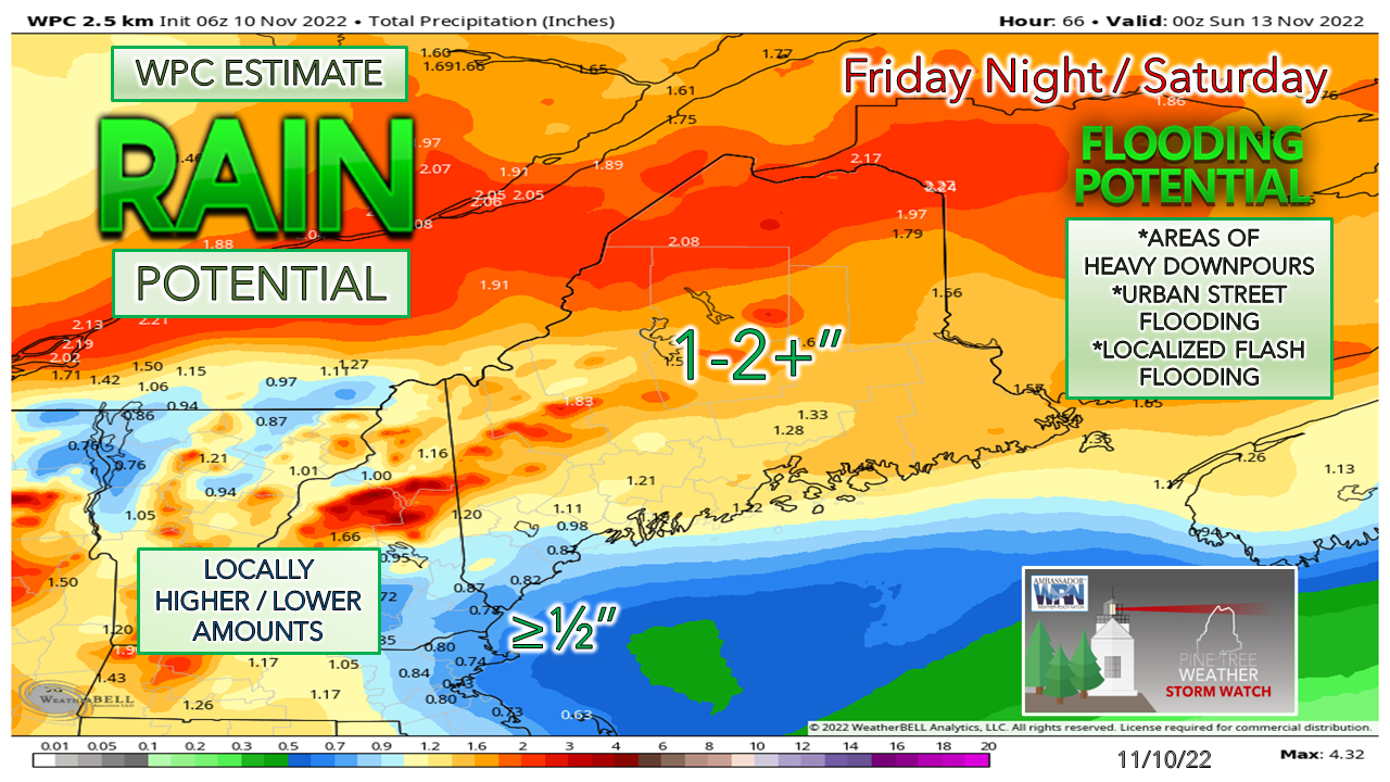 Rainfall estimate from the Weather Prediction Center articulates the impact of the southerly wind throwing rain at the western mountains upwards to Katahdin. The crown of the state could see a good dose of rain along the Allagash and Saint John Rivers. This is a base point for what to expect, but locally higher and lower amounts are possible pending on how the storm unfolds. 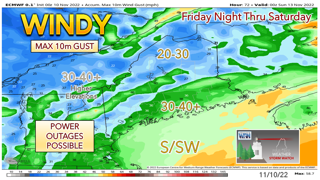 No changes to the idea I posted here on Wednesday. The main threat for the stronger gusts is for the coast and the mountains. Whether or not a wind advisory comes to fruition is yet to be seen, but either way, between the horizontal and vertical wind potential, power outages are certainly possible. 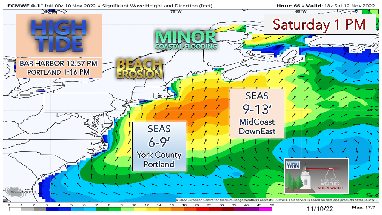 The key concern for the shorelines will be for the high tide around 1 PM. Splash-over is likely for the low-lying areas, along with potential for beach erosion. Time will tell if coastal flood statements will be issued for that. Donations needed and appreciated |

Mike Haggett
|