|
I want to thank Madelyn and Sean for stepping in at times over winter break to allow me to step back a bit, snag a bit of rest and work with them on winter forecasting. In case you missed it, Rob Koenig has started his broadcast career at WAGM Presque Isle, which I could not be happier for. I suspect we will have some sort of collaboration at times in the future, discussing weather and working with future forecasters. I am already getting inquiries from students for summer, which I am already looking forward to. I sincerely thank those who financially contribute to Pine Tree Weather for this opportunity, as without you, this would not be possible. Some slick spots possible for interior areas Sunday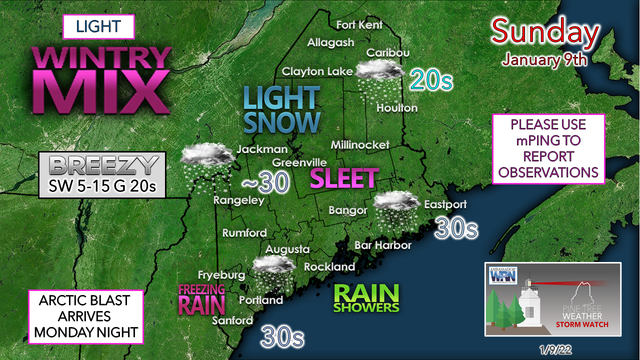 A weak warm front moves into the region for Sunday and brings a light assortment of precipitation types along with it. I don't expect any real concern for travel for those heading out, but a few slick spots on the roads and walkways less travelled are possible. 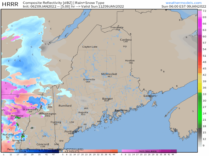 Sunday 6 AM to Monday Midnight - All areas have a chance to see a few flakes at the onset. Coastal areas may flip to a brief period of sleet and/or freezing rain before going to all rain. Areas away from the shorelines have the chance to see light amounts of snow, sleet and freezing rain off and on through the day. As quickly as the warm front moves to northeast during the day, a cold front sweeps it away in the evening, then an arctic front passes through overnight. For those traveling in the north and mountains overnight into Monday, there is a chance for a spicy snow squall or two, so keep that in mind if you are out on the roads. 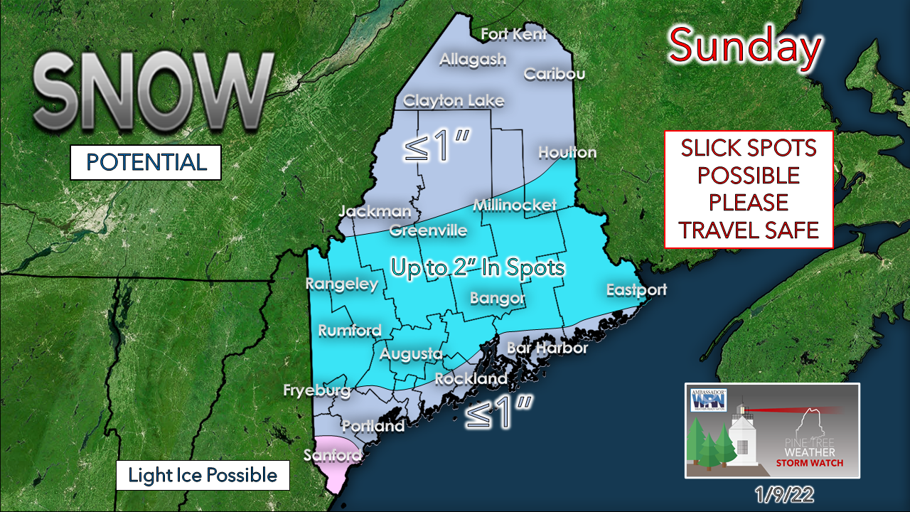 For most, a broom or leaf blower will take care of what snow comes away from the coast. Over the coastal plain, the snow may have a bit of stick to it along the surface front. Far southern areas may see a bit of ice prior to flipping to rain. Western and eastern areas have the best chance to pick up a couple inches in localized areas, but an inch or less is the general rule statewide for this event. A quick trip to the freezer to start the week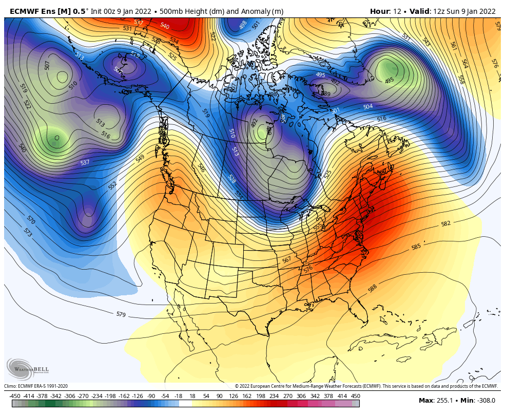 Sunday 7 AM to Friday 7 PM - A look at anomalous heights of the 500 mb atmospheric steering level at roughly 18,300 feet shows the blues and greens of well below normal heights swinging through the region to start the week. With La Niña as strong as it is, the polar vortex breaks off into pieces delivering shots of cold at times, but it is short lived. This has been the way winter has gone so far, and it appears to continue in that trend. For future snowfall interests, it is encouraging to see the ridge out west begin to build up. While the cold and steering level is conducive for snow, upper-level blocking to the north and east is missing for any snow of value. Clippers may bring snow showers to the mountains and north later in the week, but that is about it until perhaps next weekend. 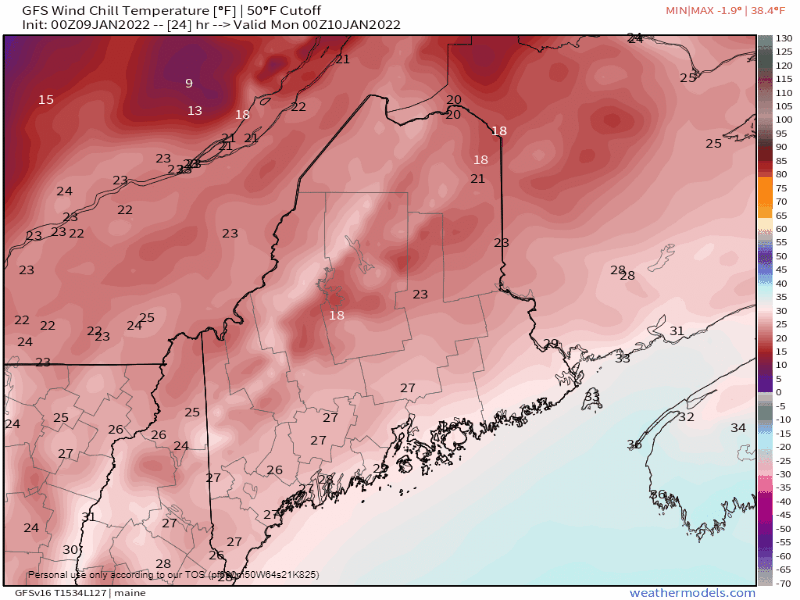 Sunday 7 PM to Wednesday 7 PM - It won't be record breaking cold, but it may burst a few pipes. Once the polar high settles in Monday night, Tuesday into early Wednesday appears frigid before modifying into the latter part of the week. Expect wind chill advisories and warnings to be issued. Keep the pipes warm in a safe manner. Storm next weekend?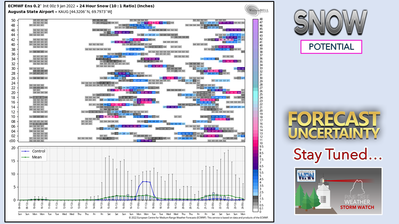 Operational ideas of the European and Canadian models are pitching the idea of a storm a week out. Ensemble ideas like the one shown for Augusta above are scattered right now. The idea of it is not out of the box. With the ridge building out west and cold in place, all that is needed is upstream blocking or a slowdown to get storm going. Stay tuned!  Temperature outlook through FridayTwo mornings of below zero starts all the way to the coast is possible for Tuesday & Wednesday. Bundle up. 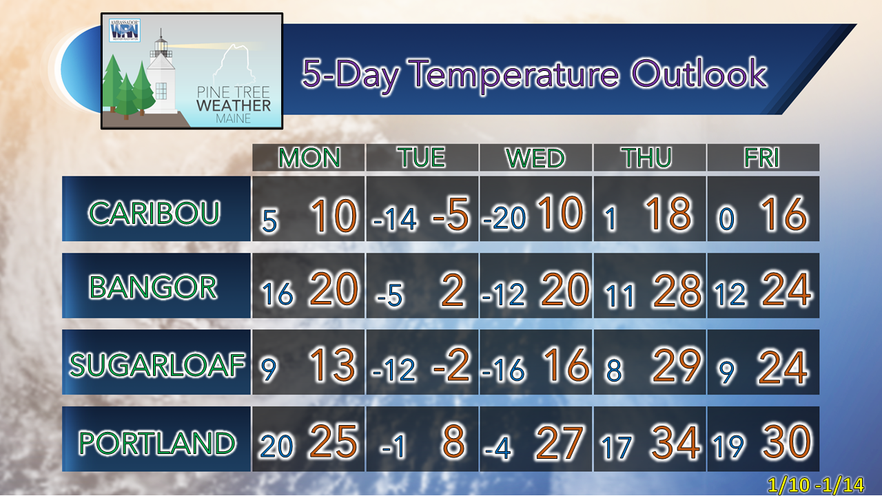 Science of Wind Chill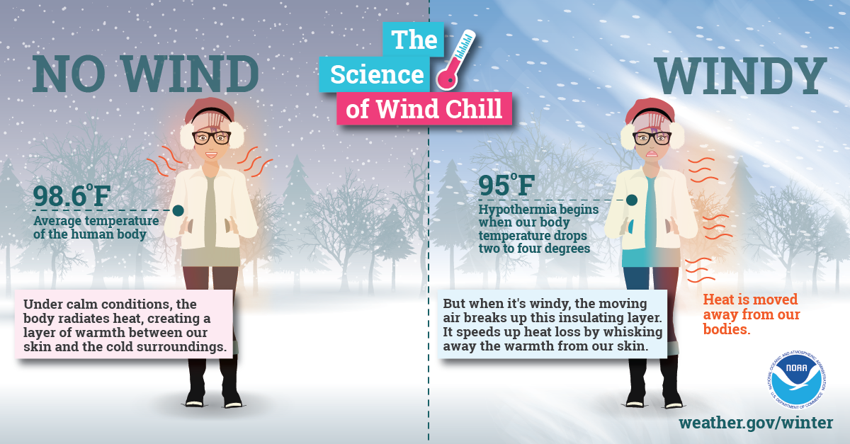 Extremely cold air affects millions of people across the United States every winter and even into parts of the spring. This Arctic air, together with brisk winds, can lead to dangerously cold wind chill values, which can cause your body to lose heat quickly. weather.gov/safety/cold-wind-chill-chart Be prepared to receive alerts and stay updated!
 For more information in between posts, please follow Pine Tree Weather on Facebook and Twitter. Thank you for supporting this community-based weather information source which operates by reader supported financial contributions. Thank you as always for your support! - Mike NOTE: The forecast information depicted on this platform is for general information purposes only for the public and is not designed for commercial use. For those seeking pinpoint weather information for business operations should use a private sector source. For information about where to find commercial forecasters to assist your business, please message me and I will be happy to help you.
|

Mike Haggett
|