 The wind will howl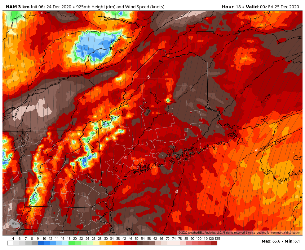 The low level jet at 2500 feet depicted here works into the region Christmas Eve night, and by Christmas morning, all areas of the coastal plain will not only feel it, but hear it. It may actually wake the inhabitants of the house up early. The timeline for the big wind to end is by early to mid-afternoon Christmas Day for western and southern areas, Christmas night for northern and eastern regions. 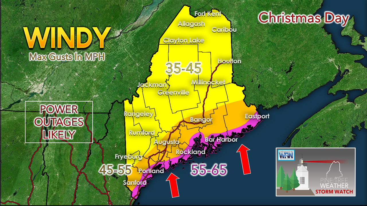 Wind gust speed forecast increased slightly. There is a good chance that shorelines hit 60 mph or higher. Speeds in the 50 mph range are possible for the rest of the coastal plain through Christmas evening. The valleys of the interior and northern areas appear to come in on the low end, but higher elevations of the mountains are concerning. This is the forecast for Mount Washington: 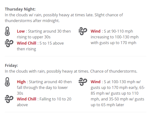 This is going to come very close to record of the strongest wind speed recorded over the winter months for The Rockpile. To put this into perspective, think back to February 2019 when the communication tower on top of Sugarloaf was turned into scrap metal. The gusts associated with this event will come close to that. Hopefully that new tower can withstand the abuse that this storm will produce. As I mentioned here yesterday, there will be six-digit level power outages most likely from this event. For western and southern areas, if you are fortunate to still have power by around 3 PM, your chances increase dramatically that you will keep it. For eastern and northern areas, if you still have it by 9 PM, your odds improve that you won't lose it. I fully suspect for some who lose power may not be back online for days. With cold air coming in behind this front, folks without generators or secondary heat sources need to be concerned about pipes freezing. If you are one of those types and lose power, it would be wise to bleed your system just in case. The rain will pour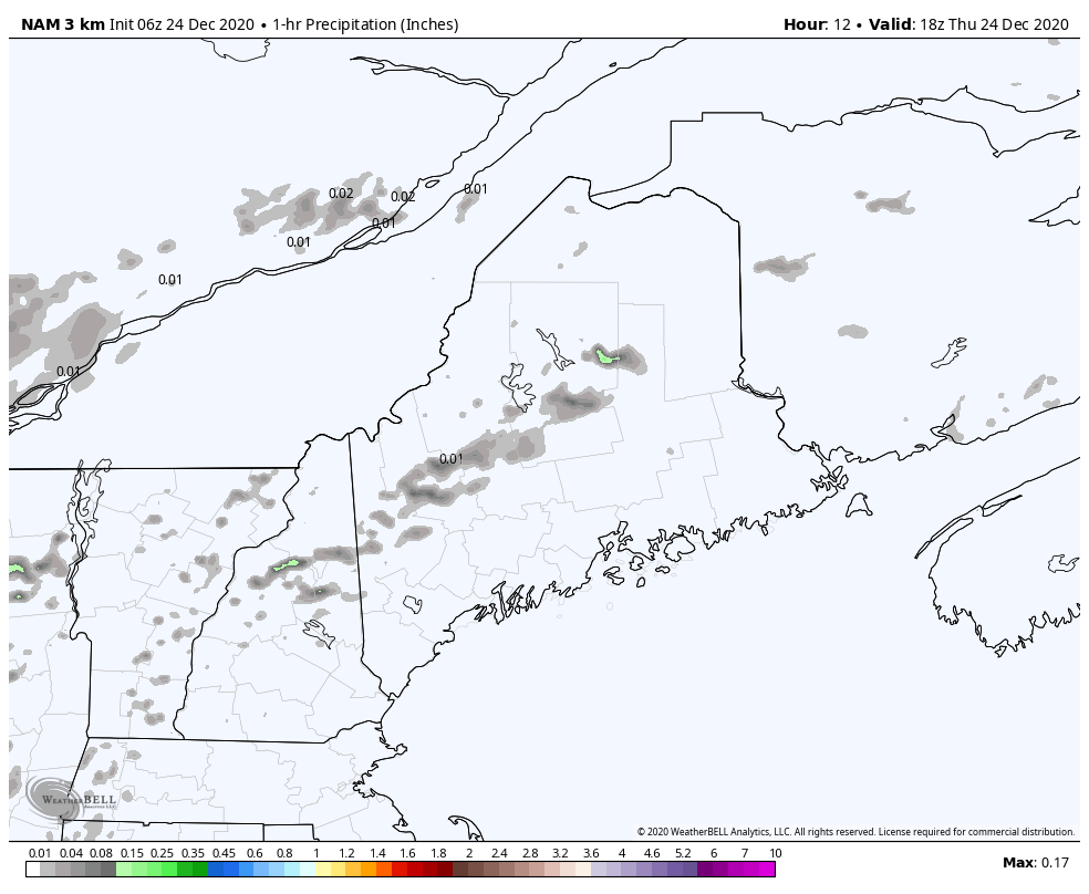 The loop of the NAM model for 1 hour accumulation of rainfall show rain developing in the mid-afternoon Christmas Eve and intensifying into Christmas morning. The rain tapers from west to east Christmas night into Saturday morning. For those who live in the mountains, please note the steady rainfall being indicated by the model here. Orographic lift is going to play a big role in your area. This will be the region of the most rainfall, and it won't be close. 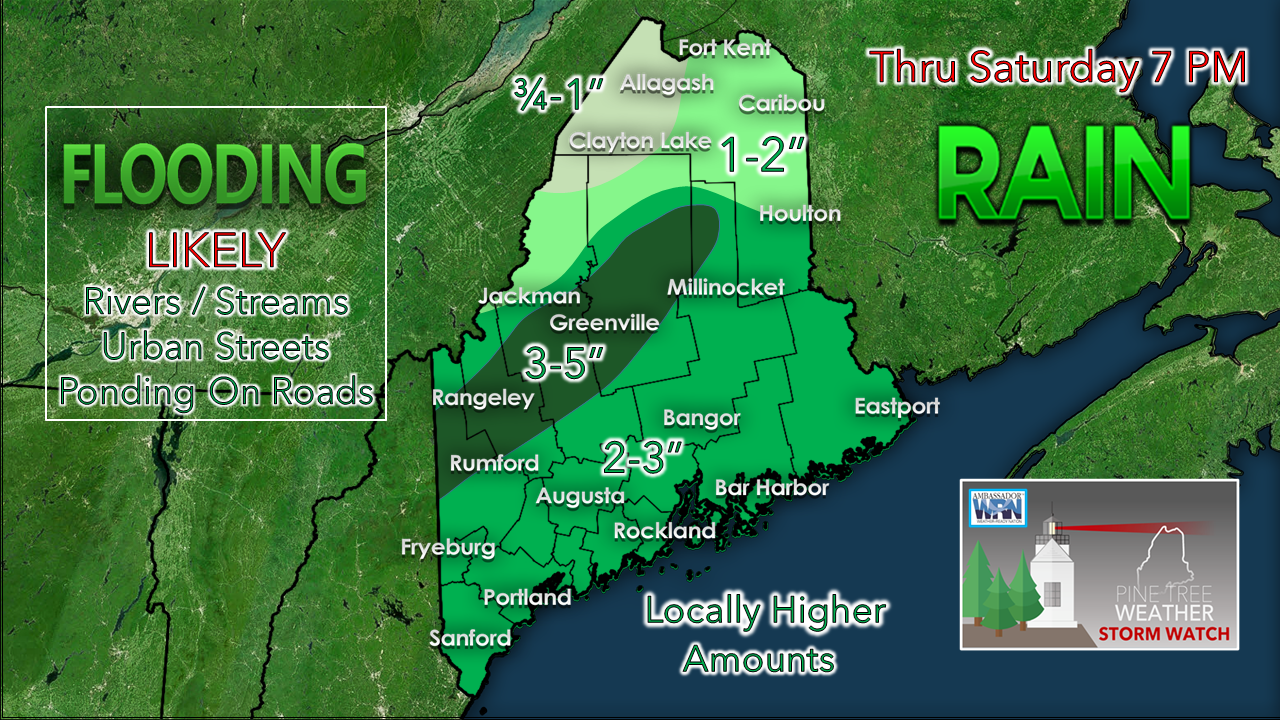 I mentioned this here on Wednesday, and I will say it again: the amount of rainfall in this forecast is essentially DOUBLED considering the snow pack contains roughly the same amount of water content. For the coastal plain, this is really a 4-5" rain event. For the mountains, it's a 5-7" rain event. Not only will the snowpack be wiped out, this is where the flooding is likely to be a moderate to major concern in some areas. With the threat for power loss from the wind, and the growing threat for flooding, you need to make sure you receive alerts and take action quickly. The snow melt and rain will flow off the slopes like a river as dew points rise into the mid to upper 40s and fog forms to eat away at the pack. Expect flooding to occur on the major rivers (Kennebec, Androscoggin, Penobscot) in the days after that. Fortunately, ice jams do not appear to be an issue here. If there is one other piece of good news here, the long standing drought since June will be completely erased after this storm. There is an old saying in forecasting community which states "Droughts never end well". This is another prime example of validating that thought. Some streets in urban settings may turn into rivers from clogged storm drains. If you are going to travel in this storm, make sure you slide into your hip boots, use both hands on the steering wheel, turn the bilge pump on, and put on a helmet. Everything freezes up by Saturday night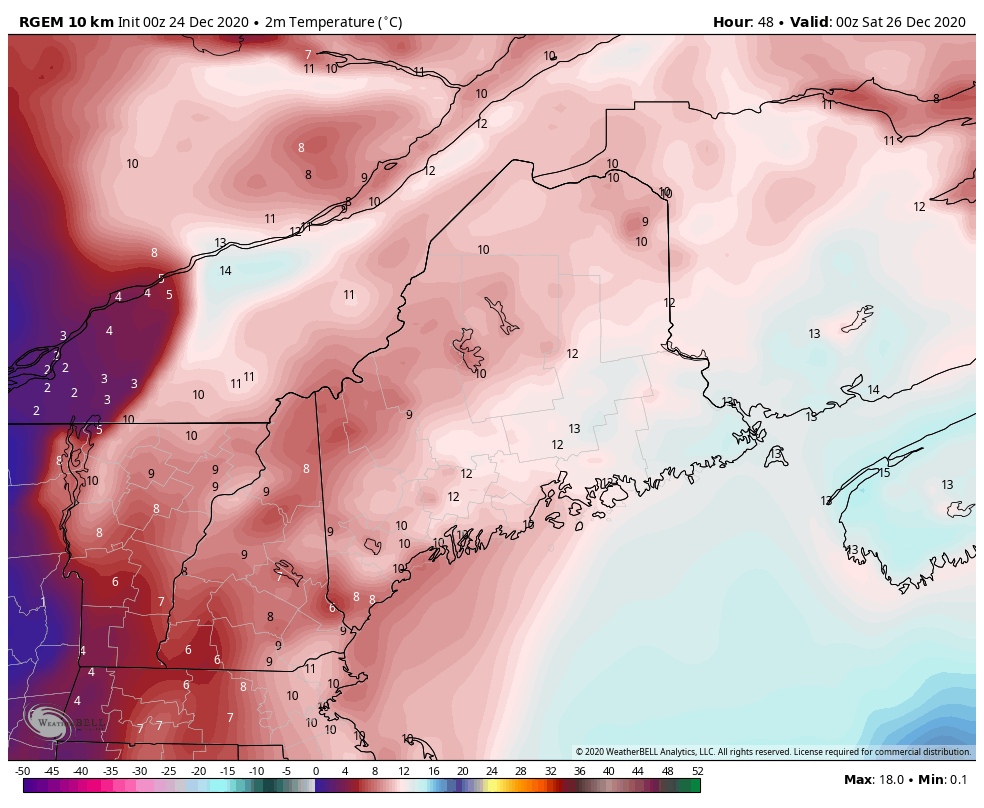 Now that the timing of this has been come into a more clearer focus, the aftermath is a cold one. Temperatures fall behind the front Friday night into Saturday. Temperatures here in Celsius to prove the point of the freezing area indicated by the shades of gray. Any standing water freezes up. Northern areas stay below freezing for the foreseeable future. Southern areas appear to stay cold for a couple of days and then warm up above freezing early next week.  Driving through flooded roads not worth the risk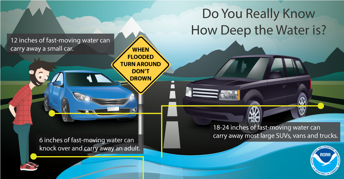 NEVER drive or walk into floodwaters. It is impossible to know how deep the water is just by looking at it. Turn Around Don’t Drown! weather.gov/safety/flood-turn-around-dont-drown Outlook and temperatures through WednesdayThe next storm works into the region Monday night into Tuesday. It appears to be a mixed bag event for now. More details on that after we get through this one and the holiday. 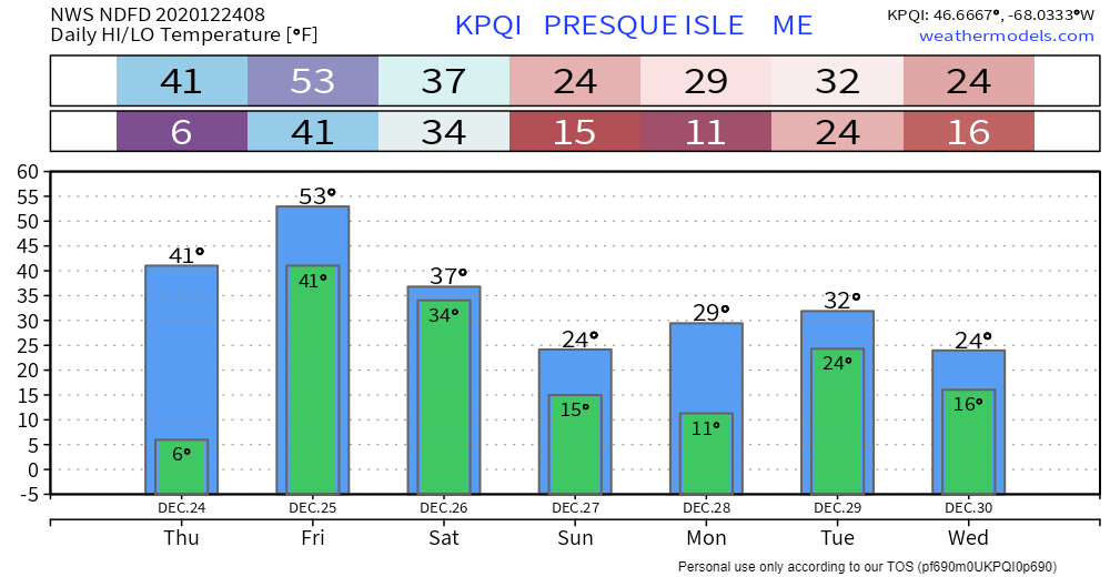 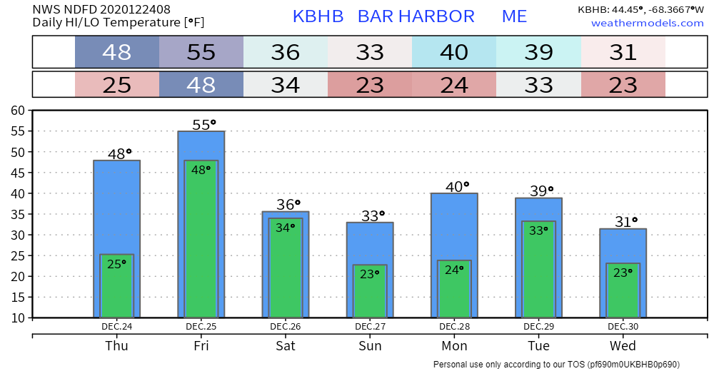 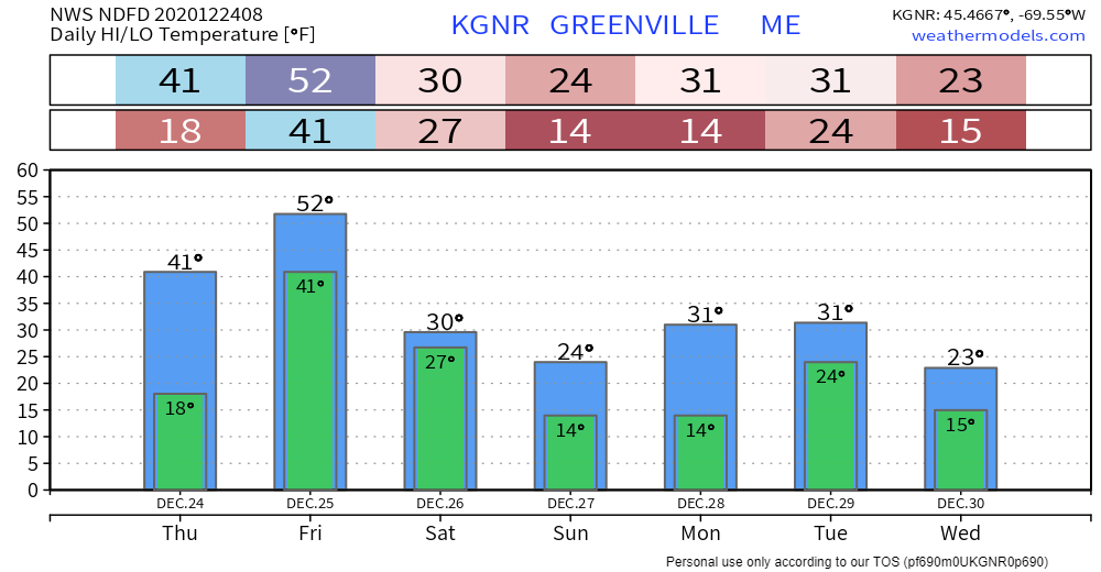 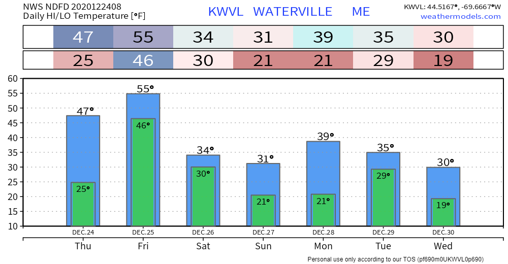 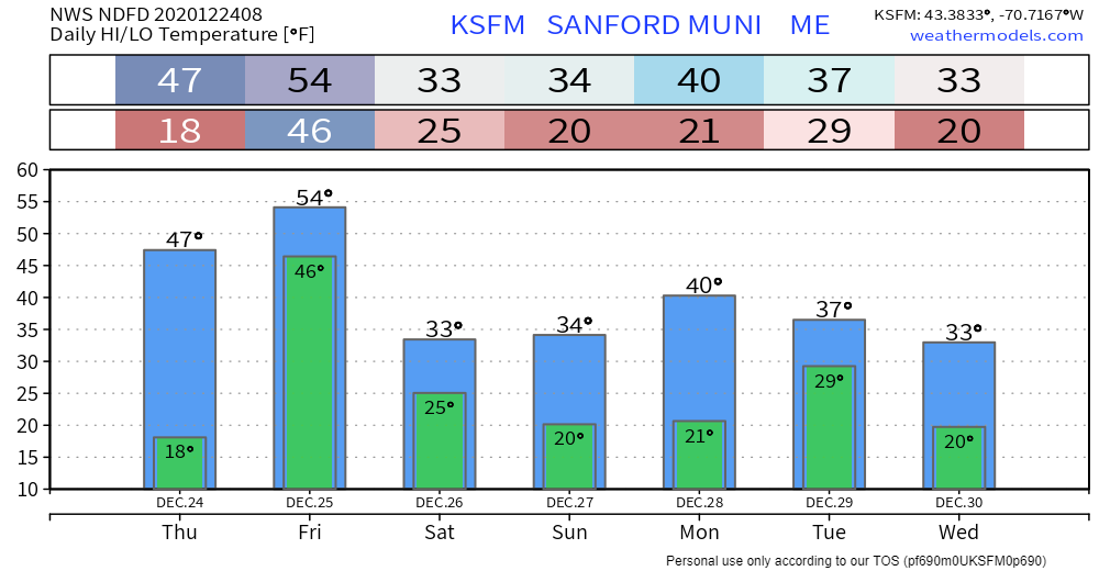 Be prepared to receive alerts and stay updated!
For more information, please follow Pine Tree Weather on Facebook and Twitter.
** FUNDING NEEDED FOR 2021 ** Thank you for supporting this community based weather information source that is funded by your financial contributions. Stay updated, stay on alert, and stay safe! - Mike |

Mike Haggett
|