Pine Tree Weather
  • DISCUSSIONS
  • DONATE
  • WEATHER WALL
  • MAPS
  • RAIN OUTLOOK
  • SEVERE
  • MARINE
  • CPC OUTLOOK
  • Kennebunk
  • MY BIO
  • PTW IN MEDIA
  • OBSERVING WEATHER
  • INTERNSHIPS
  • INTERN ALUMNI
  • DISCUSSIONS
  • DONATE
  • WEATHER WALL
  • MAPS
  • RAIN OUTLOOK
  • SEVERE
  • MARINE
  • CPC OUTLOOK
  • Kennebunk
  • MY BIO
  • PTW IN MEDIA
  • OBSERVING WEATHER
  • INTERNSHIPS
  • INTERN ALUMNI

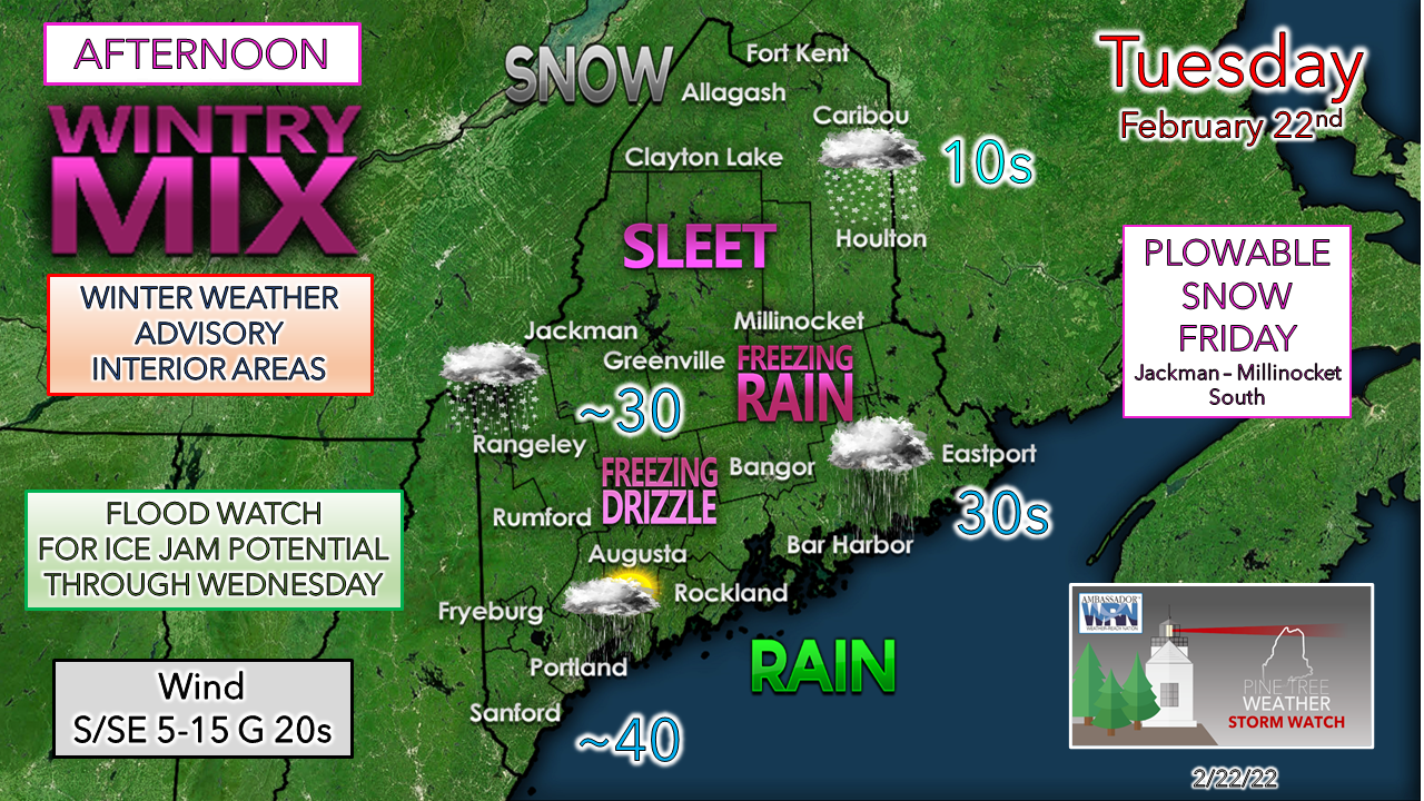
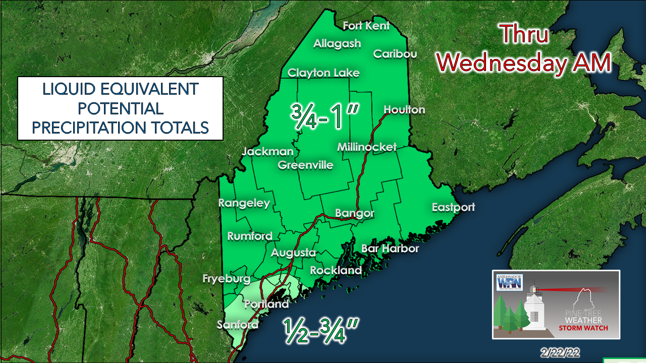
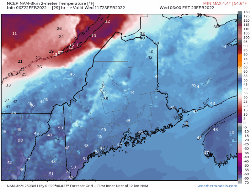
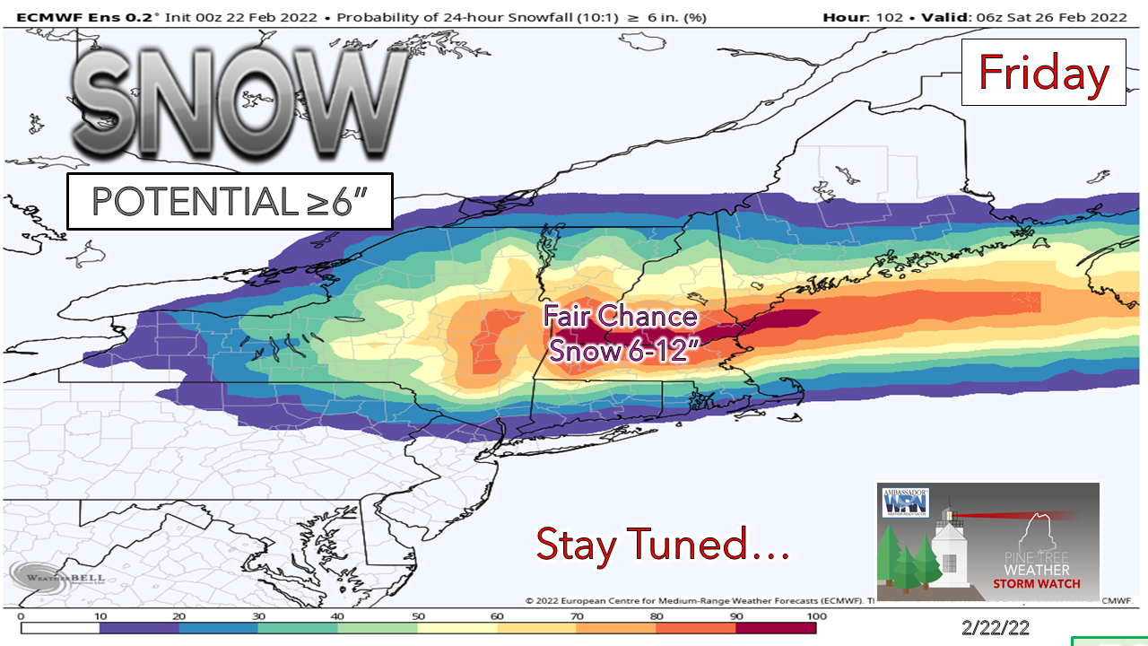
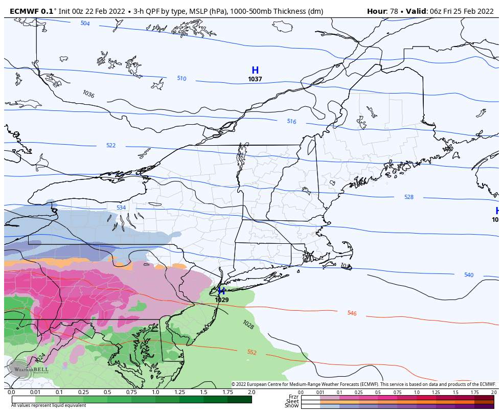
A messy mix for interior areas Tuesday, record warm temperatures possible for some Wednesday

2/22/2022

Comments

 
Before I dig into this mess, I want to own some sloppy graphical work from yesterday's post. I made a few minor mistakes on dates and spelling which I noticed after submission. I got it straightened out for this post, thanks to coffee and starting earlier at 2 AM. It may seem minor, but I do work hard to put a quality product together, and the errors in yesterday's post were unacceptable to me. 

The battle between cold and warm at the surface
​takes place over interior areas Tuesday

Picture
Today will be a day to monitor the thermometer closely. Recent rains have removed salt from roadways Warm air aloft and cold air damming doing its thing at the surface bring an ice threat to the interior Tuesday afternoon into the evening. Freezing drizzle could start around midday in the western foothills and southwest interior ahead of the main precipitation shield working in late afternoon into Tuesday night. Remember to take 5° off your vehicle thermometer and expect icy conditions for the evening commute away from the shorelines.

Updated timing and precipitation amounts

Picture
Tuesday 3 PM to Wednesday 3 AM - Again, freezing drizzle is something to watch out for in the western foothills and southwest interior around noon, and over interior northern and eastern areas in the afternoon. The main precipitation shield begins to work into southern and western areas late afternoon and expands to the north and east by early to mid-evening.  A surge of warm air moves in from the southwest Tuesday night into the wee hours Wednesday morning which should flip anything frozen to liquid as precipitation tapers to showers heading towards daylight. 
Picture
Wednesday 3 AM to 3 PM - Steady precipitation ends by daylight with most of the region in the warm sector to start the day. The far north is the only question mark of whether it rises above freezing and for how long. A cold front works through in the afternoon and may touch off upslope snow showers over the mountains and north in the afternoon. 
Picture
Accumulating ice is likely for the interior through late evening. Wind from the south / southeast flips to the southwest as the warm air surges northeast. Wind gusts in the 20-30 mph range may cause some isolated power outages, but the warm air moving in should melt any ice quickly and reduce the threat heading toward daylight Wednesday.
Picture
The National Weather Service has cut back on projected snowfall amounts for the north, which makes sense as the forecast trend is warmer. It could end up being a couple inches of pasty slop when all is said and done for the rooftop of the crown. 
Picture
The idea of ¾-1" of liquid continues to hold over much of the state. It may start solid, but it is expected to melt over most of the region as warm air moves in. 

Record high temperature potential south
​to flash freeze on Wednesday

Picture
Wednesday 6 AM to Thursday Midnight - All kinds of things going on for the day. A flood watch is posted for the western mountains and foothills between the projected rainfall and warm air is expected to cause melting and runoff. The storm last week helped agitate some ice on the rivers, and this system is expected to irritate them more. The blessing here for flood concerns is temperatures crash in the afternoon over the interior which should shut off the melting and reduce the flood threat by evening.

To the south, a southwest flow and some sun drive temperatures up around 60° by mid-afternoon. The record for Portland is 61° set in 1990, and that may fall. Warm low temperature records for Portland and Bangor may also be re-written. 

There could be areas of fog around for interior areas on Wednesday which would continue to eat at the snowpack. Flash freeze potential is a concern as temperatures dive below freezing everywhere by mid-evening Wednesday night. Expect a skating rink of frozen puddles, sidewalks, parking lots and driveways Thursday morning.

An all snow event likely for Friday

Picture
It's still a bit early to throw around any snowfall ideas of certainty, but the idea at this point is a for a York County Special where upwards of a foot of snow is possible there, with lesser amounts to the north. Northern areas may see some flakes but may not see much in the way of accumulating snow north of Jackman and Millinocket. 
Picture
Friday 1 AM to Saturday 7 AM - The storm is expected to be a quick hitter, but it could dump a healthy amount of snow over southern areas in a short period of time, thanks to mid-level forcing. The Friday morning commute may be slow but manageable, but it goes downhill as snowfall intensifies mid-morning and continues through Friday evening. This appears to be a powder snow, which will be easy to move around, but with wind could drift some. The fine tuning on how much and impacts to come. Stay tuned! 

Picture

Temperature outlook through Sunday

Other than a clipper system that is expected to pass through the region Sunday into Monday, no storms of any confidence are on the horizon until perhaps late next week. After temperatures cool through Sunday, a gradual warm up is expected to start March. 
Picture

Watch For Freezing Drizzle!

Picture
When surface temperatures are below freezing, drizzle will form a thin layer of ice on the roads. This difficult-to-see ice can cause dangerous travel conditions. When it’s drizzling in the winter, slow down, don’t use cruise control, and keep your distance from other vehicles. Don’t let freezing drizzle sneak up on you!

Be prepared to receive alerts and stay updated!

Picture
BE PREPARED WITH NOAA Weather Radio.
​​
​For $20-$40, it could provide vital information to you when you need it. The weather bands are standard on most public safety scanners, and newer scanner models. Weather radios can be programmed for auto alert. Click here for more information.

​​​► ► For the latest official forecasts, bulletins, and advisories, please check in with the National Weather Service in Gray for western and southern areas, or Caribou for northern and eastern parts of Maine.
Picture

Picture
For more information in between posts, please follow Pine Tree Weather on Facebook and Twitter. 

​Thank you for supporting this community-based weather information source which operates by reader supported financial contributions. 

Thank you as always for your support! 

- Mike

​NOTE: The forecast information depicted on this platform is for general information purposes only for the public and is not designed or intended for commercial use. For those seeking pinpoint weather information for business operations should use a private sector source. For information about where to find commercial forecasters to assist your business, please message me and I will be happy to help you.

Comments
    Picture

    Mike Haggett
    Kennebunk, ME

    Weather-Ready Nation
    Ambassador

    Certified Weather
    Forecaster
    Penn State '21

    American Meteorological Society

    National Weather Association
    ​
    ​SKYWARN-CWOP

    Matthew 19:26


    DONATE

    Picture
    Picture
    Picture
    Picture
    Picture

    Picture

    Picture

    Picture

    Picture

    Picture

    Picture

    Picture

    Picture

    Picture

    Picture

    Picture

    Picture


    Archives

    April 2025
    March 2025
    February 2025
    January 2025
    December 2024
    November 2024
    October 2024
    September 2024
    August 2024
    July 2024
    June 2024
    May 2024
    April 2024
    March 2024
    February 2024
    January 2024
    December 2023
    November 2023
    October 2023
    September 2023
    August 2023
    July 2023
    June 2023
    May 2023
    April 2023
    March 2023
    February 2023
    January 2023
    December 2022
    November 2022
    October 2022
    September 2022
    August 2022
    July 2022
    June 2022
    May 2022
    April 2022
    March 2022
    February 2022
    January 2022
    December 2021
    November 2021
    October 2021
    September 2021
    August 2021
    July 2021
    June 2021
    May 2021
    April 2021
    March 2021
    February 2021
    January 2021
    December 2020
    November 2020
    October 2020
    September 2020
    August 2020
    July 2020
    June 2020
    May 2020
    April 2020
    March 2020
    February 2020
    January 2020
    December 2019
    November 2019
    October 2019
    September 2019
    August 2019
    July 2019
    June 2019
    May 2019
    April 2019
    March 2019
    February 2019
    January 2019
    December 2018
    November 2018
    October 2018
    September 2018
    August 2018
    July 2018
    June 2018
    May 2018
    April 2018
    March 2018
    February 2018
    January 2018
    December 2017
    November 2017
    October 2017

Proudly powered by Weebly