Pine Tree Weather
  • DISCUSSIONS
  • DONATE
  • MAPS
  • NWS BRIEFINGS
  • SATRAD
  • MARINE
  • SNOW / ICE OUTLOOK
  • RAIN OUTLOOK
  • CPC OUTLOOK
  • Kennebunk
  • OBSERVING WEATHER
  • Who We Are
  • My Photography
  • DISCUSSIONS
  • DONATE
  • MAPS
  • NWS BRIEFINGS
  • SATRAD
  • MARINE
  • SNOW / ICE OUTLOOK
  • RAIN OUTLOOK
  • CPC OUTLOOK
  • Kennebunk
  • OBSERVING WEATHER
  • Who We Are
  • My Photography

A mild, windy Wednesday, winter storm watch for Friday

2/23/2022

Comments


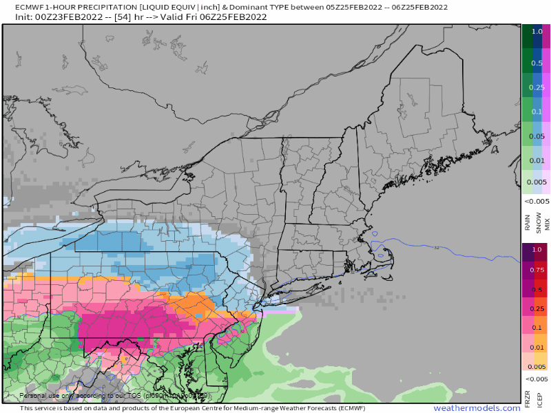
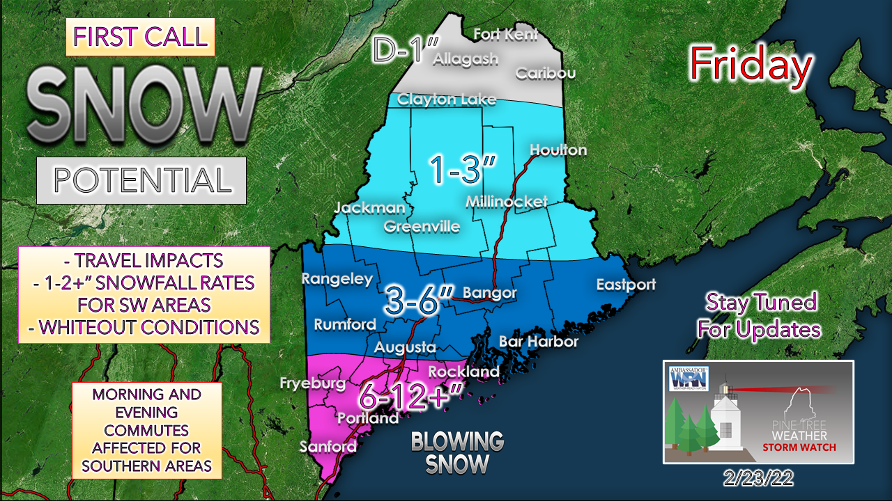
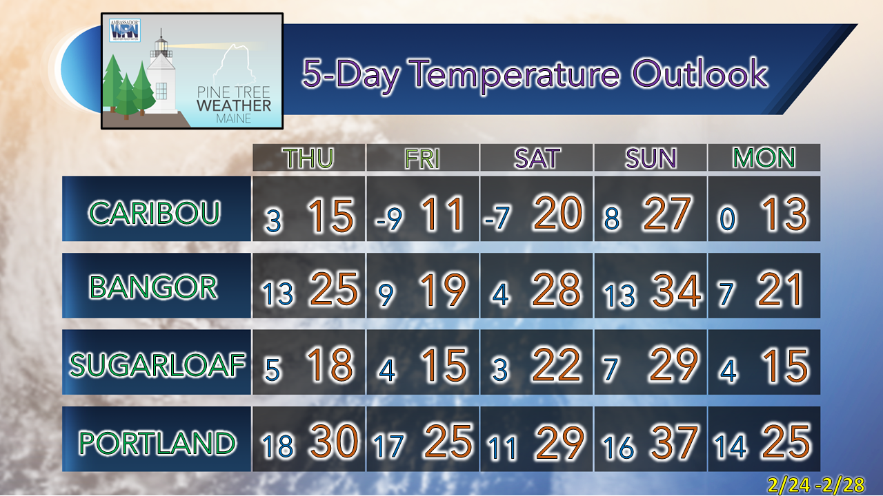
Warm to start, cold to finish

Picture
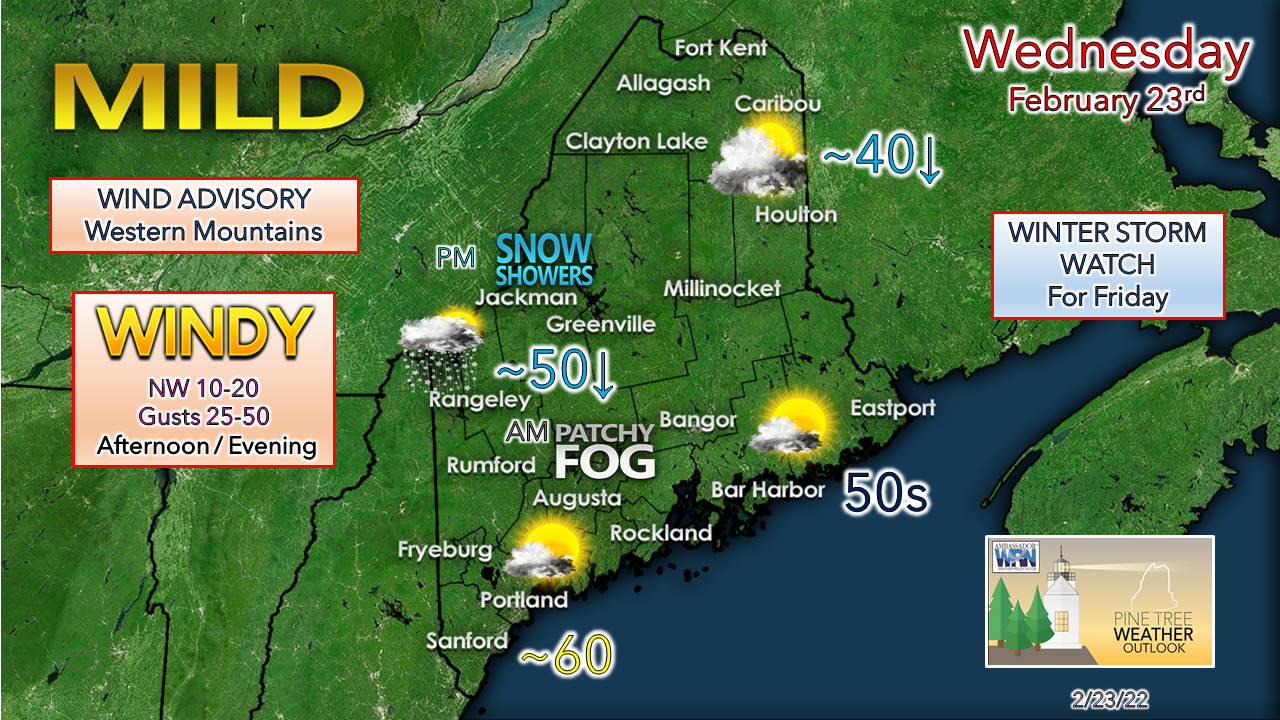
It will be one extreme to another across much of the region for Wednesday as record high temperatures are possible for Millinocket, Bangor and Portland as the mercury climbs into the 50s and 60s. The region is comfortably in the warm sector to start off, but a cold front works through in the afternoon which brings a strong, gusty wind and the thermometer to crash with all areas below freezing by mid-evening.

A wind advisory is posted for the western mountains where a downslope wind could reach 45-50+ mph late in the afternoon into the evening. The wind gradually settles down as high pressure pays a quick visit for Thursday.

Winter storm watch posted
​for southwestern areas Friday

Picture
Friday 1 AM to Saturday 1 AM - I have to say guidance has been generally consistent with the idea of this storm all week, which is encouraging to this forecaster as the mid-range outlook has been a challenge all season.  Snow develops over southern and western areas Friday morning in time for the commute and spreads to the north and east though the morning. Snow could be heavy at times through the afternoon over southern and Mid-Coast areas where accumulation rates could be in the 1-2" an hour range and could make the evening commute a slow adventure. Northeast winds fetch up as the storm organizes itself and could gust in the 20-30 mph range and blow snow around and create whiteout conditions at times through the early evening. The snow tapers off from west to east Friday evening.
Picture
Confidence is good for southwestern areas for a decent event. High pressure to the north over central Quebec could spoil potential snowfall outside of the watch area as dry air could eat it up. This is a powder snow event for the area with snow to water ratios roughly 12:1. Since this is a flat system in the early stages of development, that may throw a wrench into the quality and size of the snowflakes which could alter snow amounts higher or lower depending on the circumstances. Expect an update on the forecast for a better idea on Thursday. 

Picture

Temperature outlook through Monday

The weekend continues to look to be on the cool side as a Canadian High works into the area for Saturday. Snow showers and squalls are possible for Sunday as a spicy clipper passes through. Monday appears breezy with wind chills below zero in the north and single digits south.  
Picture

Driving in Patchy Fog

Picture
Driving in fog can be dangerous. Be on the lookout for sudden changes in visibility. The patchy nature of fog can lower visibility quickly and unexpectedly, especially if you are driving fast, so be sure to slow down. Visibility may also be lower near rivers. weather.gov/safety/fog

​Be prepared to receive alerts and stay updated!

Picture
​BE PREPARED WITH NOAA Weather Radio.
​​
​For $20-$40, it could provide vital information to you when you need it. The weather bands are standard on most public safety scanners, and newer scanner models. Weather radios can be programmed for auto alert. Click here for more information.

​​​​► ► For the latest official forecasts, bulletins, and advisories, please check in with the National Weather Service in Gray for western and southern areas, or Caribou for northern and eastern parts of Maine.
Picture

Picture
For more information in between posts, please follow Pine Tree Weather on Facebook and Twitter. 

​Thank you for supporting this community-based weather information source which operates by reader supported financial contributions. 

Thank you as always for your support! 

- Mike

​NOTE: The forecast information depicted on this platform is for general information purposes only for the public and is not designed or intended for commercial use. For those seeking pinpoint weather information for business operations should use a private sector source. For information about where to find commercial forecasters to assist your business, please message me and I will be happy to help you.

Comments
    Picture

    Mike Haggett
    Kennebunk, ME

    Certified Weather
    Forecaster
    Penn State '21

    American Meteorological Society

    National Weather Association

    Weather-Ready Nation 
    Ambassador
    ​
    ​SKYWARN-CWOP

    Matthew 19:26


    Support
    Pine Tree Weather

    DONATE

    Picture

    Picture

    Picture

    Picture

    Picture

    Picture

    Picture

    Picture

    Picture

    Picture

    Archives

    January 2023
    December 2022
    November 2022
    October 2022
    September 2022
    August 2022
    July 2022
    June 2022
    May 2022
    April 2022
    March 2022
    February 2022
    January 2022
    December 2021
    November 2021
    October 2021
    September 2021
    August 2021
    July 2021
    June 2021
    May 2021
    April 2021
    March 2021
    February 2021
    January 2021
    December 2020
    November 2020
    October 2020
    September 2020
    August 2020
    July 2020
    June 2020
    May 2020
    April 2020
    March 2020
    February 2020
    January 2020
    December 2019
    November 2019
    October 2019
    September 2019
    August 2019
    July 2019
    June 2019
    May 2019
    April 2019
    March 2019
    February 2019
    January 2019
    December 2018
    November 2018
    October 2018
    September 2018
    August 2018
    July 2018
    June 2018
    May 2018
    April 2018
    March 2018
    February 2018
    January 2018
    December 2017
    November 2017
    October 2017

    RSS Feed

Proudly powered by Weebly