Pine Tree Weather
  • DISCUSSIONS
  • DONATE
  • MAPS
  • NWS BRIEFINGS
  • SATRAD
  • MARINE
  • SNOW / ICE OUTLOOK
  • RAIN OUTLOOK
  • CPC OUTLOOK
  • Kennebunk
  • OBSERVING WEATHER
  • Who We Are
  • My Photography
  • DISCUSSIONS
  • DONATE
  • MAPS
  • NWS BRIEFINGS
  • SATRAD
  • MARINE
  • SNOW / ICE OUTLOOK
  • RAIN OUTLOOK
  • CPC OUTLOOK
  • Kennebunk
  • OBSERVING WEATHER
  • Who We Are
  • My Photography

A mixed bag and windy Monday; breeze continues into Tuesday

12/6/2021

Comments


An assortment of meteorological phenomena
to start the week

Picture
The atmosphere will be busy at times over the region for Monday. Winter weather advisories are posted for the interior for snow and light ice. Wind advisories are posted for MidCoast, DownEast and Bangor areas for gusty wind ahead of and behind the approaching front. A coastal flood statement is posted for the shorelines for minor flooding and splash-over.  Make sure you are aware of the weather statements issued by the National Weather Service and take appropriate action if necessary.

Since this is storm is multi-faceted, I will break down the potential impacts.

Wind could bring power outages in areas

Picture
Monday 6 AM to Tuesday 6 AM (average speed at 10 meters) - For the morning, it's important to note how little wind gets into the western foothills. This is cold air damming doing its thing here thanks to a solid low-level inversion which will take a while to wash out. As the front approaches Monday afternoon, wind speeds increase in that region as well as the rest of the state. Notice the sharp front that passes through 9 PM to 1 AM. This is where the strongest gusts appear to occur, and where the greatest potential exists for power loss. Wind speeds remain elevated into Tuesday as high pressure moves into the region, keeping the breeze stiff and cold through the day, gradually settling down heading into Wednesday morning.

Keep your phones charged, and make sure you have what you need in case you lose power for a period of time.

Slick spots for interior areas 

Picture
Monday 6 AM to 6 PM - The idea here of the timing of precipitation has not changed much from what I posted here on Sunday. I do think the western foothills on up into the Great North Woods may get enough ice to slick up the roads less traveled and untreated surfaces. Expect the Maine DOT and local towns to run the trucks treating the roads. As the wind picks up this afternoon, temperatures warm into the 40s and allow the drivers to rest for a few hours, and travel should be alright other than you may need two hands on the wheel on the speedier roads.

There will be a break in the action for much of the region in the afternoon before the front arrives in the evening. 
Picture
A slight alteration to the snowfall map, but what remains on track is the Allagash region are likely to see the higher end totals. 
Picture
Monday 6 PM to Tuesday 6 AM - This is where the heaviest of the precipitation passes through the region along with the strongest wind. Given the sharp nature of the front, the risk for thunder in the form of either rain ahead of it or in a quick flash of snow on the backside of it is certainly possible here. The western mountains may a get pasted with a sloppy inch of snow in the transition, and snow squalls are possible heading into Tuesday morning. 
Picture
There is not much change in the amount of potential liquid here. Southern areas moved up a tad from yesterday's idea from the Weather Prediction Center. 

With the sharp nature of the boundary passing through and a shot of liquid out ahead of it, black ice will be a concern heading into Tuesday.

Temperatures rise during the day, crash overnight

Picture
Monday 6 AM to Tuesday 6 AM - The HRRR model here is a bit warm for the southwest interior and the foothills in the morning, but it shows the afternoon surge of warmth ahead of the front well. After the front passes through Monday night, temperatures fall off a cliff and cool by 20° by daylight Tuesday. Add a gusty wind to that and chop off another 10°. It could feel like single digits, teens and 20s pending on where you are Tuesday morning, and temperatures continue to gradually fall during the day. 

Watch for areas of black ice over interior areas Tuesday morning.

mPING reports appreciated today! 

Picture
​Check out the mPING (Meteorological Phenomena Identification Near the Ground) project. Weird name, cool app! You can report the type of precipitation you see where you are. No need to measure! Use the free mobile app to send reports anonymously. Reports are automatically recorded into a database, which improves weather computer models. The information is even used by road maintenance operations and the aviation industry to diagnose areas of icing. mping.nssl.noaa.gov

Current deficit for 2022 - $270

Picture

Tracking midweek snow

Picture
There is still a fair amount of uncertainty with this. Inverted trough / potential Norlun trough set ups are always tricky. Ideas have shifted from the MidCoast to the southwest coast for now, and I am still not quite convinced this is the final answer yet. I will keep track and advise on this.

The next system after this comes in the form of a warm front that works in Thursday night into Friday which could bring light snow for the the interior and rain for the coast. Stay tuned for more on that . 
Picture

​​Be prepared to receive alerts and stay updated!

Picture
​BE PREPARED WITH A NOAA Weather Radio.
​
​For $20-$40, it could provide vital information to you when you need it. The weather bands are standard on most public safety scanners, and newer scanner models. Weather radios can be programmed for auto alert. Click here for more information.

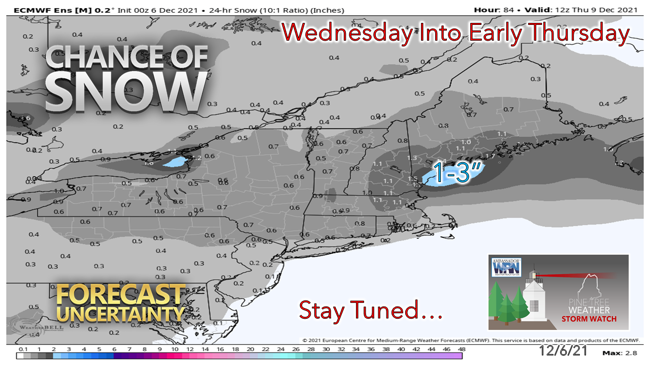
​​​► ► For the latest official forecasts, bulletins, and advisories, please check in with the National Weather Service in Gray for western and southern areas, or Caribou for northern and eastern parts of Maine.
Picture

Picture
For more information in between posts, please follow Pine Tree Weather on Facebook and Twitter. 

​Thank you for supporting this community-based weather information source which operates by reader supported financial contributions. 
​
​- Mike
Comments
    Picture

    Mike Haggett
    Kennebunk, ME

    Certified Weather
    Forecaster
    Penn State '21

    American Meteorological Society

    National Weather Association

    Weather-Ready Nation 
    Ambassador
    ​
    ​SKYWARN-CWOP

    Matthew 19:26


    Support
    Pine Tree Weather

    DONATE

    Picture

    Picture

    Picture

    Picture

    Picture

    Picture

    Picture

    Picture

    Picture

    Picture

    Archives

    January 2023
    December 2022
    November 2022
    October 2022
    September 2022
    August 2022
    July 2022
    June 2022
    May 2022
    April 2022
    March 2022
    February 2022
    January 2022
    December 2021
    November 2021
    October 2021
    September 2021
    August 2021
    July 2021
    June 2021
    May 2021
    April 2021
    March 2021
    February 2021
    January 2021
    December 2020
    November 2020
    October 2020
    September 2020
    August 2020
    July 2020
    June 2020
    May 2020
    April 2020
    March 2020
    February 2020
    January 2020
    December 2019
    November 2019
    October 2019
    September 2019
    August 2019
    July 2019
    June 2019
    May 2019
    April 2019
    March 2019
    February 2019
    January 2019
    December 2018
    November 2018
    October 2018
    September 2018
    August 2018
    July 2018
    June 2018
    May 2018
    April 2018
    March 2018
    February 2018
    January 2018
    December 2017
    November 2017
    October 2017

    RSS Feed

Proudly powered by Weebly