
Enough snow to dust things up a bit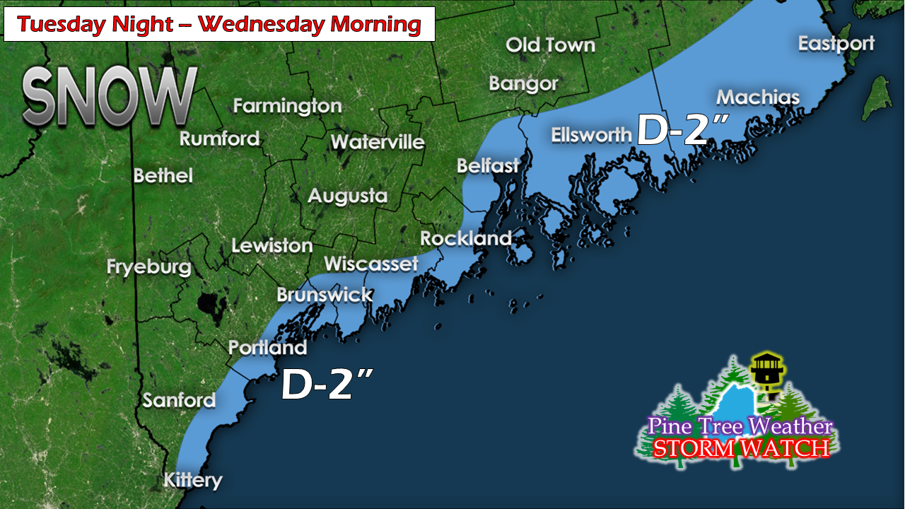 As I mentioned on the Facebook posts Sunday night and Monday morning, there is a chance for some light snow for the higher elevations of the mountains as well as the shorelines as a weak front slides through the region late Tuesday night into early Wednesday morning. As the boundary moves into the Gulf of Maine, the trough may enhance a bit and potentially cause some light accumulations of snow. Best chance for higher end totals (2") would be DownEast as is appears for now. These troughs are tricky to forecast, and bust potential is high. I will advise on this on Tuesday. Quiet until Saturday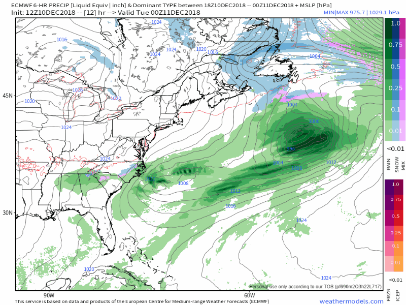 Six hour steps of model ideas through Saturday shows one storm passing well out to sea midweek, along with a split flow heading into the weekend. At one time, models were phasing the northern and southern streams together forming a significantly larger wintry mix to rain event over northern New England. That does not appear to happen. Cold air from Siberia appears to disrupt the upper level flow, causing a system from the north not to join the system in the south. Had this occurred, the snow pack over much of the state could have taken a hit from heavy rain or possible ice event. There is likely to be a light wintry mix for the interior and potential for some light showers for the coast, but high pressure associated from the Siberian cold appears to steer heavier amounts of rain to the south. There is still room for changes, but the idea has become more consistent over the past couple of days. Stay tuned. Above normal temperatures heading into Christmas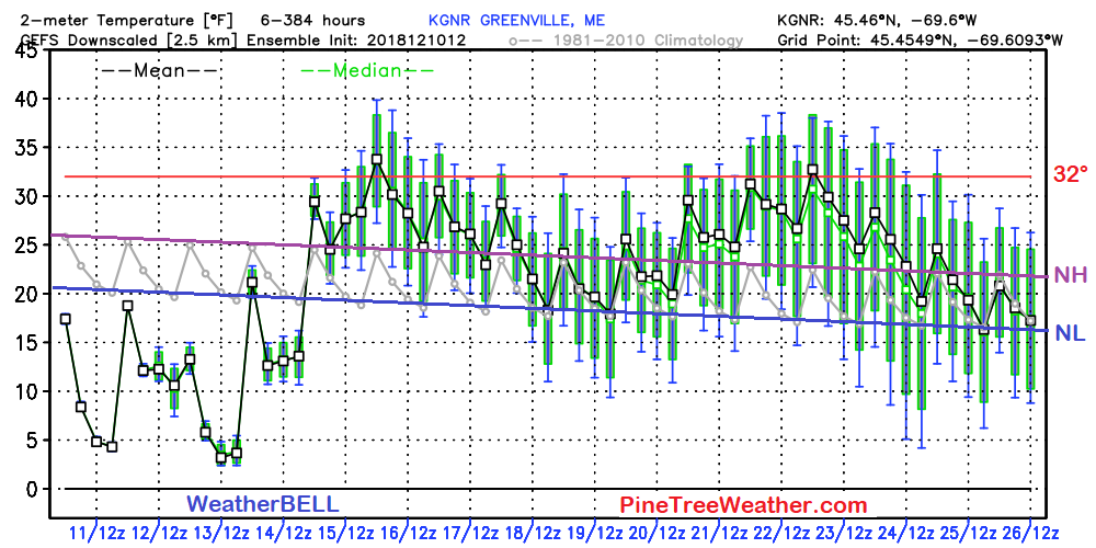 We all know is has been cold for much of December with temperatures running below normal for several of the first ten days so far. That trend appears to change starting this weekend. Normal highs (NH) and lows (NL) are typically below freezing (32°) this time of the year in the north, and close to it in the south. While temperatures appear to be a few degrees above normal as we head into the later stages of the month, the mercury over the interior may not venture too far above 32°. Coastal plain areas such as Bangor and Portland areas may flirt with 40° off and on, but mid to upper 30s (3-5°+ normal) appear to be the trend. It's not exactly flip-flop weather, but it may balance out what has been an abnormally cold month to this point. Outlook through Saturday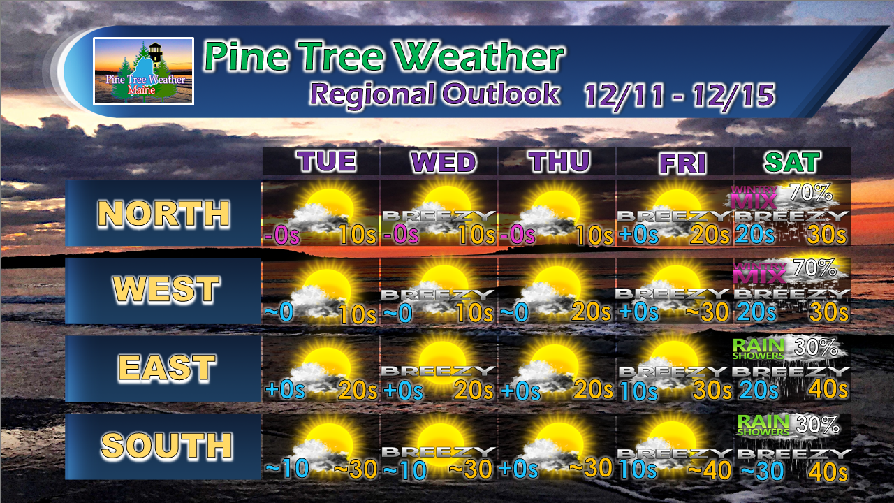 Expect some very chilly starts in northern areas through the remainder of the workweek as below zero starts appear the rule for the rooftop. Along with the cold thermometer readings, wind chill won't make it feel like it is much above zero once the mercury says so. Temperatures begin to increase with the pattern shift going into the weekend. For the latest official forecasts, bulletins and advisories, please check in with the National Weather Service in Gray for western and southern areas, or Caribou for northern and eastern parts of Maine. Thank you for your support! Please consider making a donation to keep Pine Tree Weather going through the year ahead. My data cost expense is increasing. The operation is 85% funded and needs your help to get through the winter. You can set up a monthly pledge on my Patreon page or send me a message from the Facebook page or direct message on Twitter to get my address to mail a check.
For more information from me, please follow the Pine Tree Weather Facebook page and my Twitter feed. Always stay weather aware, and thank you for your support! - Mike |

Mike Haggett
|


