|
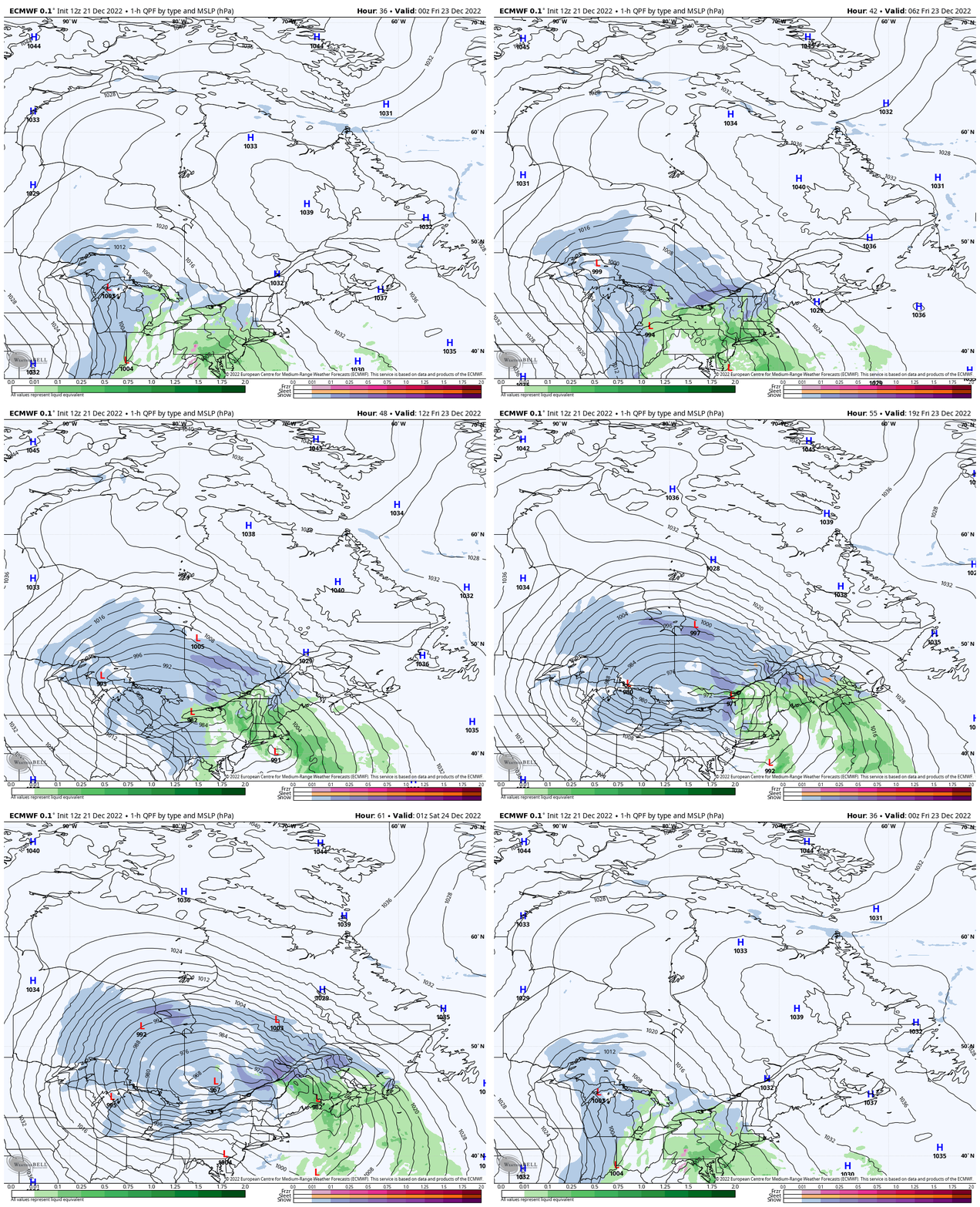
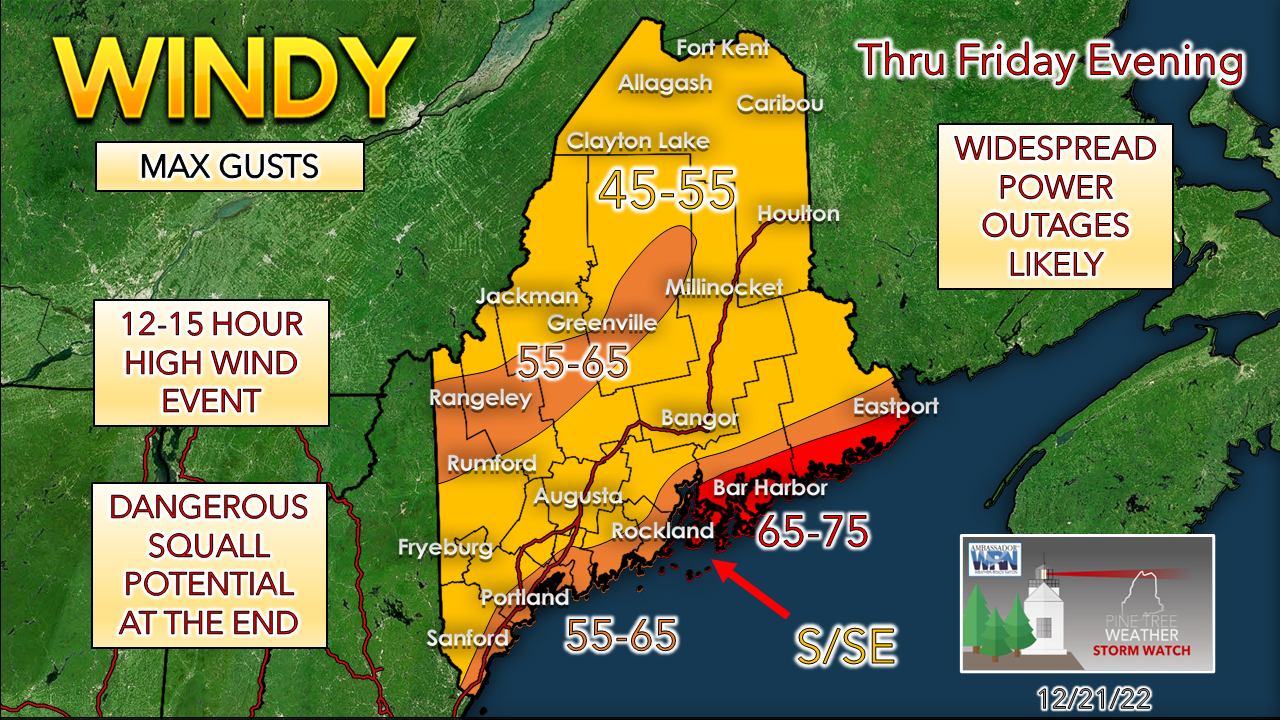
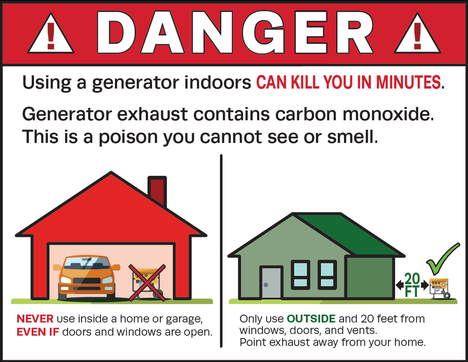
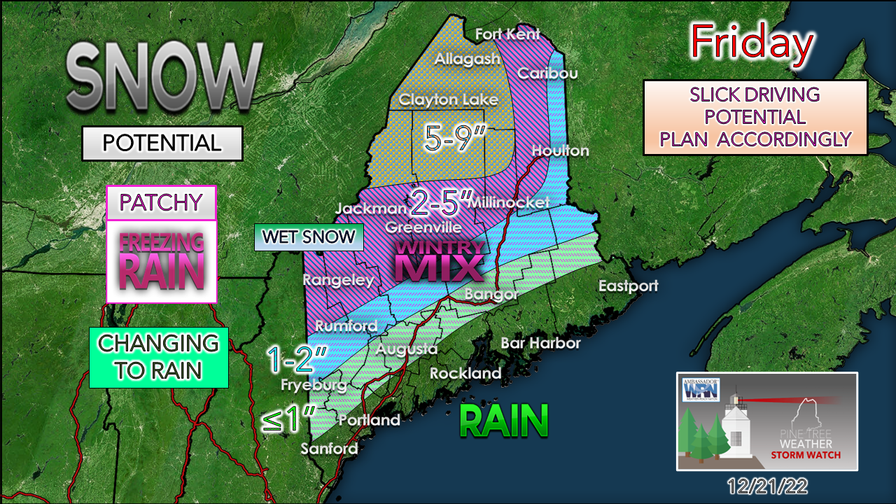
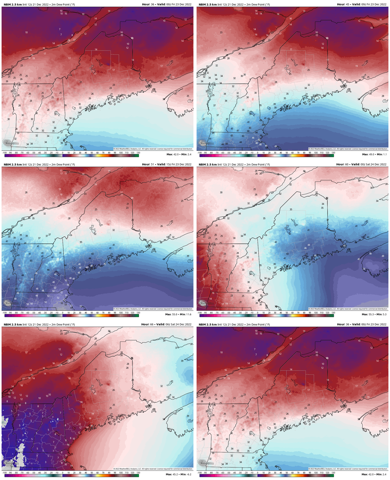
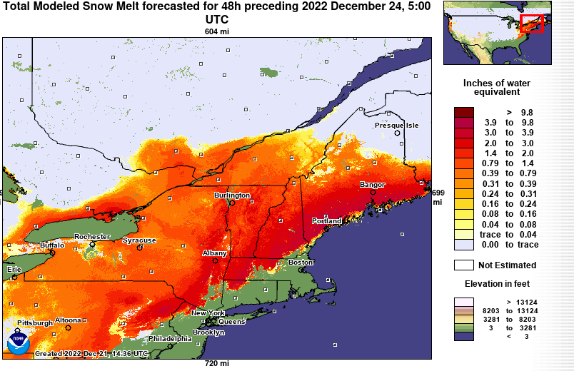
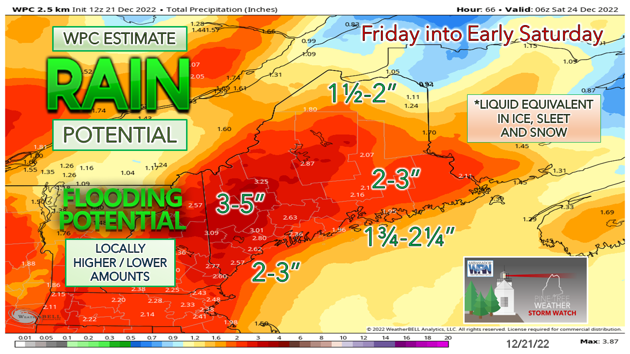
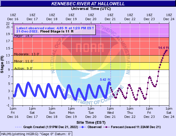
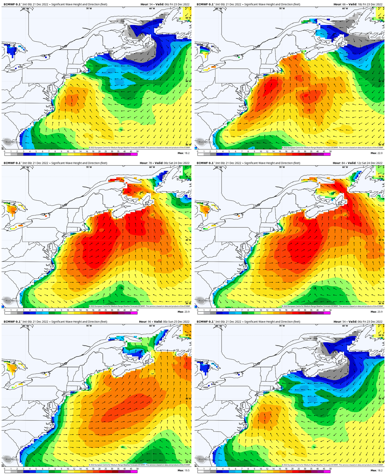
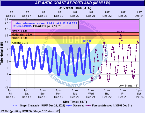
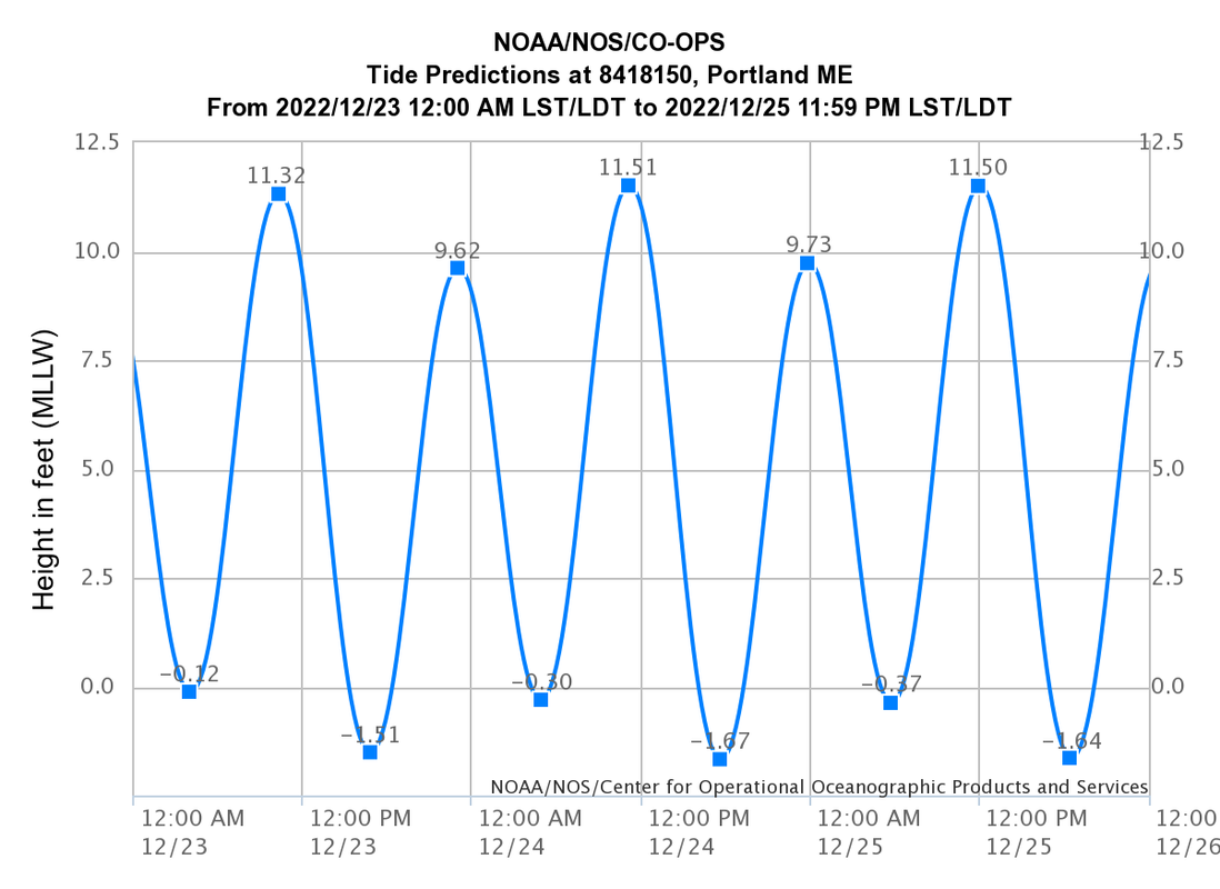
Every now and then we get a storm that is placed in our memory banks as one to remember. This is one that is poised to do that. I am not one to use the term "historic" loosely. I think I have only used that term a handful of times in the past 11 years. Whether it will get that tag put on it or not, only the results of the storm will dictate that. I am confident that this one won't be easily forgotten, and will be discussed around holiday gatherings for a number of years. Someone came up with the idea of "The Grinch Storm" and has spun around the Twittersphere and I think it fits the bill. I am not going to call it whatever the other major weather TV network is calling it, because I don't get into that sort of thing. For a high impact weather event this close to Christmas that will likely spoil many parties, it's perfect. It's a major stormThursday 7 PM to Saturday 1 AM - Let's talk about fact and fiction here. FACT: this is a rapidly developing synoptic storm that will go through bombogenesis (pressure drop of 30mb or more in 24 hours). FICTION: This has the same intensity as a CAT2 hurricane. I don't get why some want to do that sort of thing when it isn't the same storm core species other than to scare people. Let's go with the FACT here. It's shaping up to be a big bomb, no question. Between the high to the west and the predicted pressure of the storm, there could be some pressure records established between the two. Any time a storm drops 35mb in roughly 18-20 hours, it's not good. The Siberian Express of cold slamming into a mild upper ridge brings blizzards, heavy rain, big wind, and a whole lot of work and headaches to recover from. The timing of precipitation appears to begin over the south and west in the wee hours of Friday morning, and end early evening. For eastern areas, expect it to start around sunrise and end by mid-evening. For the north, mid to late morning to start and around midnight - 1 AM Saturday to end, outside of snow shower that may persist in logging country until Saturday morning. The big story is the windThe graphic here spells it all out. Timing of the wind in conjunction with precipitation for beginning and end. The word on the street is a power company is preparing for six figure power outages (200,000+). Knowing there is another power company with a slightly smaller account number in an area that is likely to get hit the worst, so tack on another 100,000 as a conservative estimate and bring the idea up to 300,000ish is my over / under for now. I am not a weather risk manager by any stretch, but knowing full well what the October 2017 storm did with similar dynamics, that is what potentially see here. Restoration efforts will be in sub-freezing temperatures through Christmas as temperatures crash behind the front, and hopefully most folks are back on by New Years, and it should warm up by then. For those that manage to keep lights on through most of it will have one final hurdle to deal with as the front itself comes through at the end, and expect it to have temper. Don't be surprised if severe thunderstorm warnings get handed out like candy canes at the local Christmas fair as damaging downdraft winds occur. If you manage to get through all of that and stay plugged in come Saturday morning, you should be all set. Just a friendly reminder here to use your generator safely in a well-ventilated area. Make sure you have plenty of fuel to operate it as well in case roads are blocked with trees. Really. Precipitation ideas roughly the sameWith the general idea of the storm tracking to the east a bit more brings more snow to logging and moose country, and the higher elevations of the ski hills. The threat for some light snow and some freezing rain is distinct possibility for the coastal plain and the foothills on up into the east side of The County. It all changes to rain with the possible exception of the Allagash region that sees the lowest chance for liquid. If anyone has a few flatbed trailers and tractors around to load up the ski hills in western areas and take them north to avoid the rain and the melting of snow, I suggest you get on the stick and do it now. Times a wastin'. Thursday 7 PM to Saturday 7 AM - A look at the rise and fall of dewpoint temperatures here. Where the dew points rise above freezing with the strong southeast wind, which is predicted to be for most of the state, expect the snow to ripen and being to melt, with help from the slug of rain on the way. The good news is the dew points crash like a high speed train into a wall to slam the brakes on the melting, but not after about 12-hours or so of loss. The White Christmas for the coast is all but gone and the ski mountains do take a hit, but they may not lose all they have achieved recently. With the southeast flow, rain gets blasted into the mountains where the highest amounts are expected. The snowpack ripens, melts and releases 1-3" of additional water with the rain and warm dewpoints and that sets up flooding for brooks, streams, rivers, roadways, and basements. Flood watches have been posted across western, eastern and southern areas and for good reason. Expect Route 201 in Hallowell to become part of the Kennebec River as we head into Christmas. This is going to be brutal to have flooding with temperatures below freezing as it happens. While there is little ice on the rivers to be concerned for jam issues, it's likely to be a horrific mess there and any other area of flooding that happens, and expect many areas to flood. Then there is the coastal impactsThe marine forecast for Penobscot Bay south and Penobscot Bay north paint the picture of seas upwards of 22 feet by Friday night. With astronomical high tides in play along with roughly 4 feet of storm surge brings moderate coastal flooding, splash-over, some localized inundation, and beach erosion from the battering waves. Even after the storm passes, the ocean will be angry until Sunday night. The shorelines are all under a Coastal Flood Watch due to the predicted mayhem, with moderate flooding already predicted for Portland Friday just before noon. The high tides through Christmas are ones to watch as the ocean continues to settle from the irritability caused by the atmospheric eruption. Splash-over and minor flooding may continue through the holiday. Closing thoughtsI may sound a bit aloof here but the message is clear. The bottom line here is this going to be a bad storm at a bad time. It is likely to cause disruption, disappointment, frustration, anger, anxiety, and depression for some. We're Mainers. We're tough. We come together, and we'll get through it. Check on your neighbors, and touch base with your friends. Help out if you can. Have baked goods to give to the line workers and hot coffee & cocoa for them if you have a generator to make it. If you can reschedule your holiday, do it just in case. If you can't, do the best you can with what you have. This will be a storm that will be remembered for a long time, hopefully for not was lost, but for how we as Mainers rallied together to get through it, by helping one another. Be safe, stay updated on the bulletins and forecasts from NWS. I will do my best to get you through Friday, if I don't lose power or internet. Don't let the Grinch steal the joy and the spirit of the holiday for what it was meant to be. Funding deficit for 2023 ... $750Thank you as always for your support! You may not like the weather, but I hope you like what I do! Please hit the like button on Twitter and Facebook, and share! Stay updated, stay on alert, and stay safe! - Mike NOTE: The forecast information depicted on this platform is for general information purposes only for the public and is not designed or intended for commercial use. For those seeking pinpoint weather information for business operations, you should use a private sector source. For information about where to find commercial forecasters to assist your business, please message me and I will be happy to help you. |
Mike Haggett
|

