
Pardon me if you've seen this movie before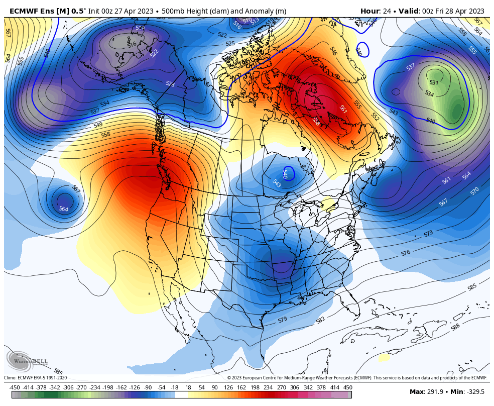 For those that caught my last post here on the website a week ago, the pattern coming up for the seven days is very similar to the past week. For those longing for sunshine, Friday is THE day for that. I am looking into the long term over the next 10 days and all I see is clouds and chances for rain. The troffy pattern over the eastern part of the country continues with blocking to the north and east. The upper-low moving into the region appears to be a bit stronger and a bit more stubborn than the one experienced over this past week. This is spring being spring. The chilly air that has been bottled up over the Arctic for most of the winter is eroding. Bits and pieces of the tropospheric polar vortex are being chipped away, and eastern North America is the recipient of this gift. 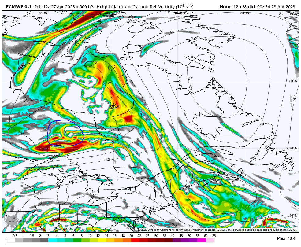 A look at vorticity at the key steering level in the atmosphere shows a wave being dragged up from the south ahead of the main bowling ball. It is on track to bring low pressure in for Sunday and a strong Sou'Easter into the area Sunday night into Monday. It will get caught in an atmospheric traffic jam and bring wave after wave of clouds and showers through the week and may bring a backdoor cold front as a parting gift as we head into next weekend. An inside runner to bring heavy rain and wind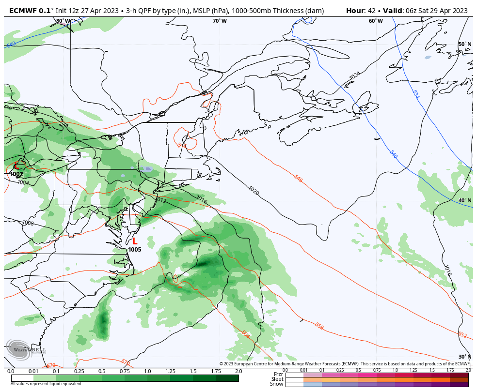 Saturday 4 AM to Tuesday 8 AM - A weak area of low pressure forms along the Mid-Atlantic coast during the day on Saturday. For most areas, it appears to be a dry day, with the only question mark is over the southwest, where the strength of the ridge that gives the region a break on Friday holds the cards on whether it holds the rain off or not. As the upper-low deepens over the Great Lakes, it drags up rapidly intensifying low from the Gulf of Mexico, which brings plenty of juice and potential for strong wind along with it. Sunday appears to start off with showers with rain becoming more widespread in the afternoon and heavy overnight into Monday. As the low becomes occluded (weakens) and a dry slot works in, that shuts the faucet off during the day on Monday, outside of a few widely scattered showers. The upper low slowly moves toward the region by Tuesday, and thanks to the blocking, it will hang around like an annoying housefly through the rest of the week. 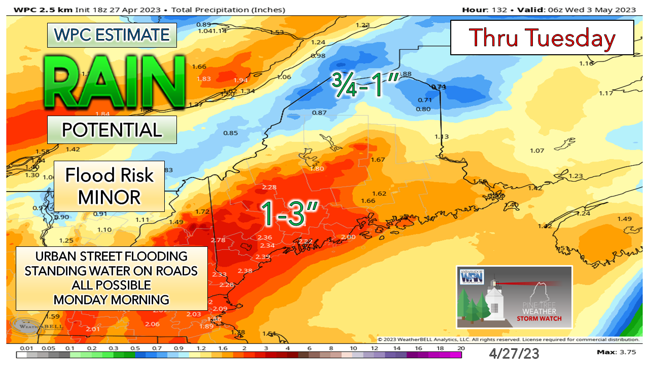 While this is the idea for now, I will note that history indicates that these southeast storms have a tendency to overperform with rainfall. That is completely on the discussion board here. Folks travelling Sunday night into Monday morning could see heavy downpours, reduced visibility from fog and the rain, along with urban street flooding and hydroplane potential. The other risk is the potential for some localized flash flooding as the recent rains have the ground well saturated in many areas, along with snowmelt over the mountains. This is a good basis point to start off for now, but the idea of 2-5" of rain as the result by Tuesday wouldn't surprise me, with the mountains seeing the higher end amounts. 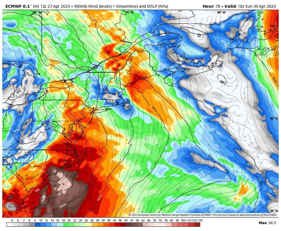 Sunday 2 PM to Tuesday 2 AM - Sou'Easter events can bring a concern for strong gusty wind and the ideas at this point indicate that potential. This is the low-level jet (NOT surface wind) depicted here. Anytime we have storms with a tropical moisture hose, the threat of downdraft wind mixing to the surface exists, especially with heavy rain. With the LLJ here peaking out potentially between 60-80 knots, which could bring surface gusts of 40-50 mph. I don't want to get the cart too far ahead of the horse as it is still a bit early, but if the idea holds serve, there could be some power outages. The coast and the mountains are likely to get the brunt of the wind. The strongest gusts pass through overnight Sunday into early Monday morning. 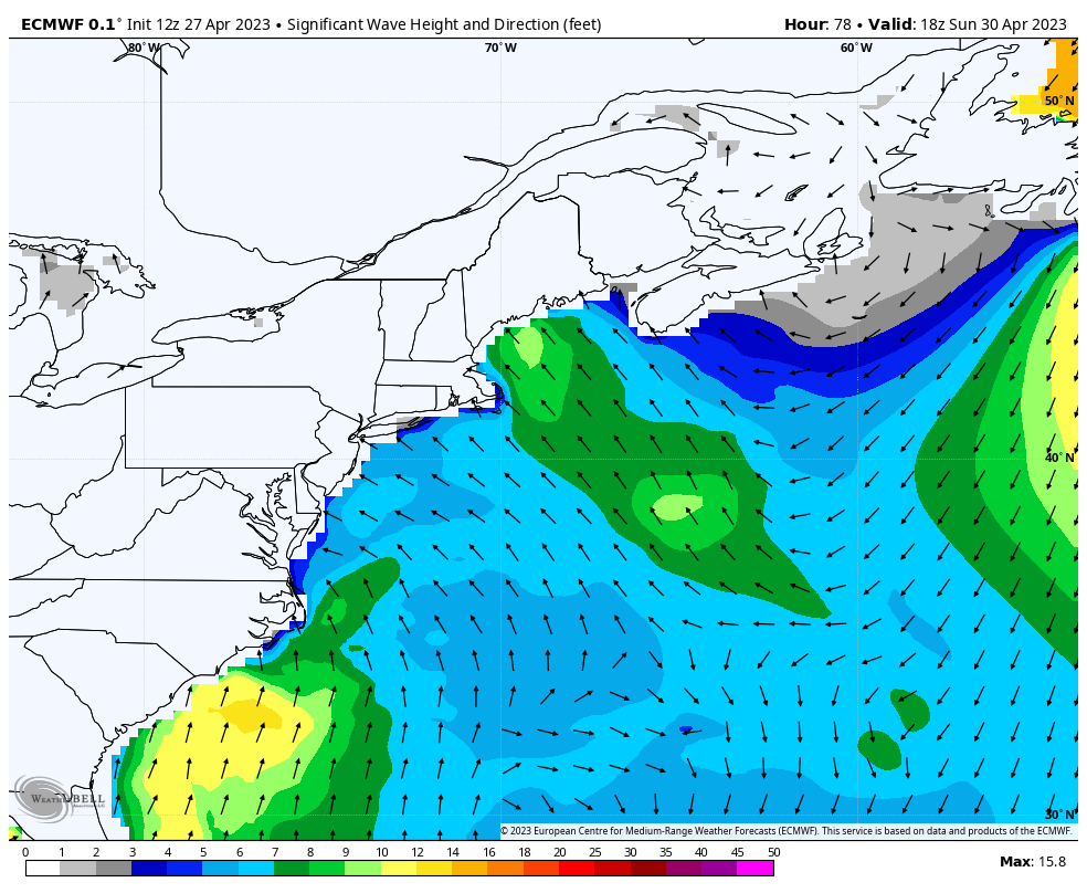 Sunday 2 PM to Tuesday 8 AM - For those with shoreline concerns, the good news is astronomical tides are not an issue here. That said, this system may provide a foot or two of storm surge and battering waves. The forecast from the National Weather Service calls for waves in the 7-12' range. The peak of the wind comes with low tide in the 2 AM time period Monday morning, which helps to reduce the risk of too many issues. There could be some splash-over with the 8 PM high tide Sunday and 8 AM on Monday, along with potential for beach erosion. Folks with shoreline concerns should keep updated on the forecast. Temperature outlook through TuesdayWhile the outlook over the next week temperature wise is generally cool, it does not appear to be as cool as what has been experienced over the past few days. I do expect a sea breeze to develop Friday which will drop temperatures for the coastal plain after a warm start. We could be well into May before the discussion of widespread 60°+ temperatures come again, along with sun. 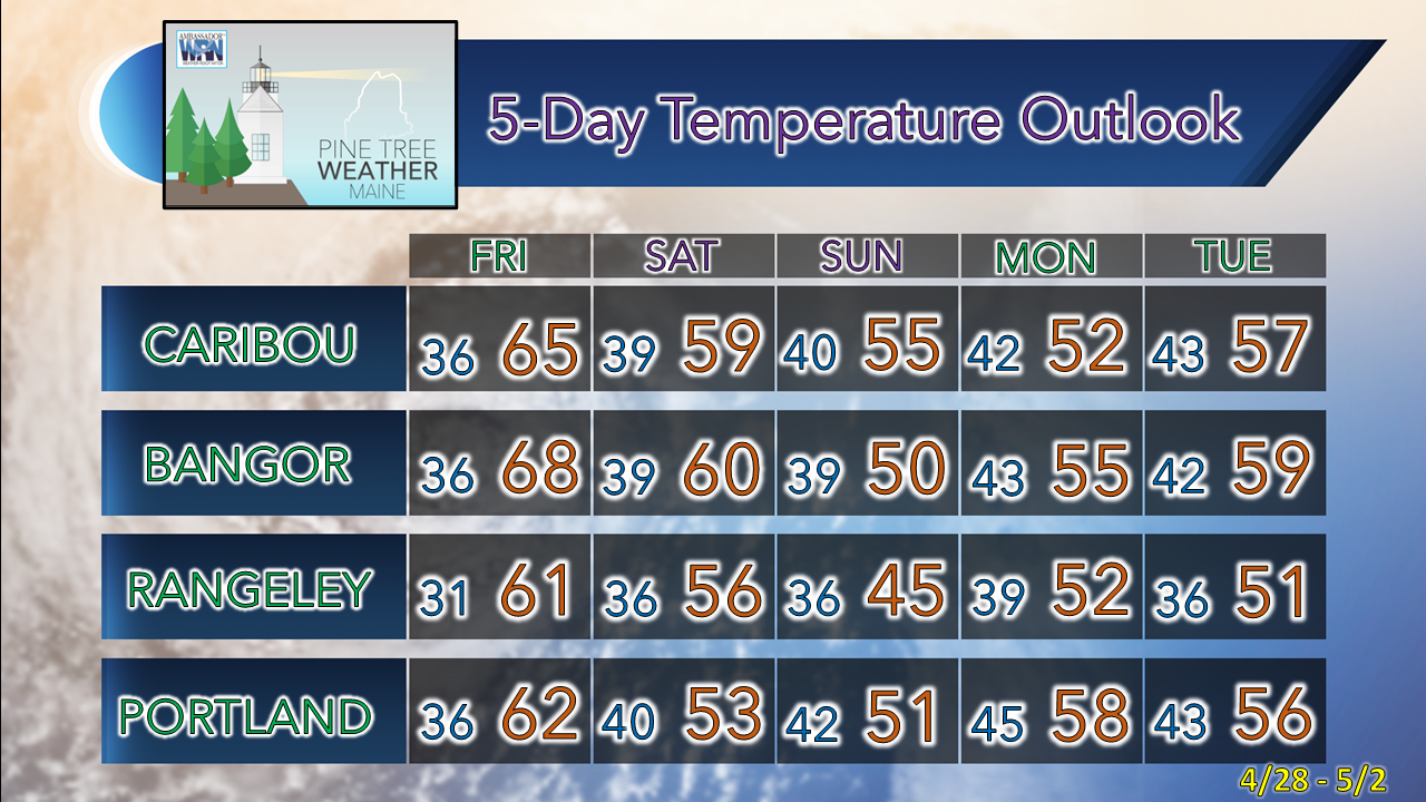  Pine Tree Weather is funded from followers like you. I would appreciate your financial support. Click here for how you can contribute. You may not like the weather, but I hope you like what I do! Please hit the like button on Twitter and Facebook, and share! Stay updated, stay on alert, and stay safe! - Mike NOTE: The forecast information depicted on this platform is for general information purposes only for the public and is not designed or intended for commercial use. For those seeking pinpoint weather information for business operations, you should use a private sector source. For information about where to find commercial forecasters to assist your business, please message me and I will be happy to help you. |

Mike Haggett
|


