Mild for all, damp for the mountains and north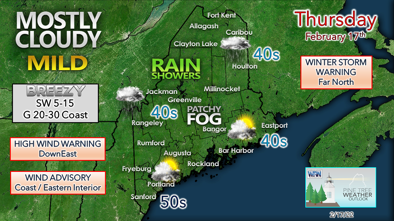 Clouds rule the day as warm air associated with an upper-level ridge wedges in the northeast. Coastal areas may see the sun peek through here and there. Rain showers are the story for the western mountains and north where a tenth to ¼" of liquid could fall during the daylight hours. Mild air continues to surge in thanks to a southwesterly breeze. 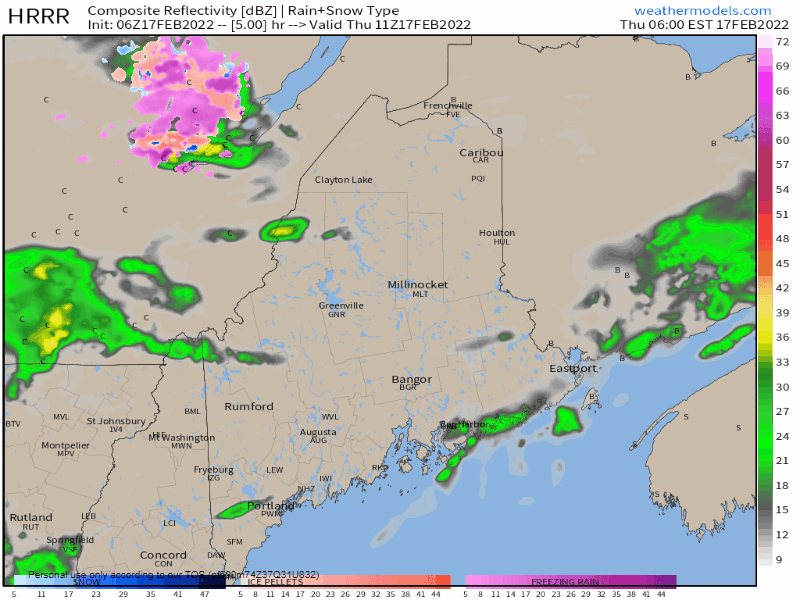 Thursday 6 AM to 6 PM - A frontal boundary to the northwest remains virtually stationary during the day. Moisture streams up along it and brings shower activity to the mountains and north, with perhaps a stray shower over the western foothills and eastern interior. With the increase of dew points, areas of fog and patchy drizzle are possible. Front passes through Thursday night into Friday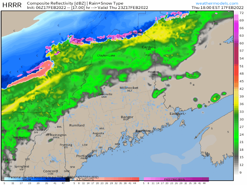 Thursday 6 PM to Friday 6 AM - The frontal boundary begins its dissention across the region Thursday night. Rain over the far north flips to snow, with perhaps some mixing of sleet and light ice for The County and the north woods. Rain is the dominant precipitation type for areas to the south. Expect a wet, windy night for the shorelines as a strong low-level jet may bring strong gusts to the shorelines and interior areas of the MidCoast and east, which could bring spotty power outages. 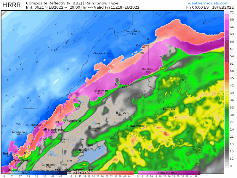 Friday 6 AM to 1 PM - The front passes to the east Friday morning, ending precipitation. Northwesterly winds begin to crank on the backside to assist in ushering cold air back into the region with temperatures falling during the day. Any areas that see ponding on roadways from snow melt run off and rain could see if freeze up and cause slick spots on roads, parking lots, driveways, and sidewalks. Snow showers are possible for the mountains on Friday afternoon. 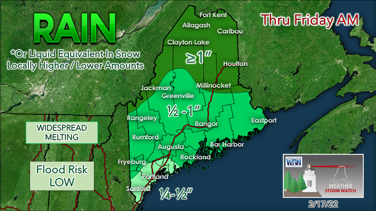 The heaviest amount of precipitation remains over the far north. Western areas along the Quebec border that continue to deal with drought from last winter could get a healthy drink. The snowpack will take a hit between the mild dew points, rain and fog, but may escape with minimal impacts. Flooding does not appear likely, but runoff may agitate some ice on the smaller rivers and streams. 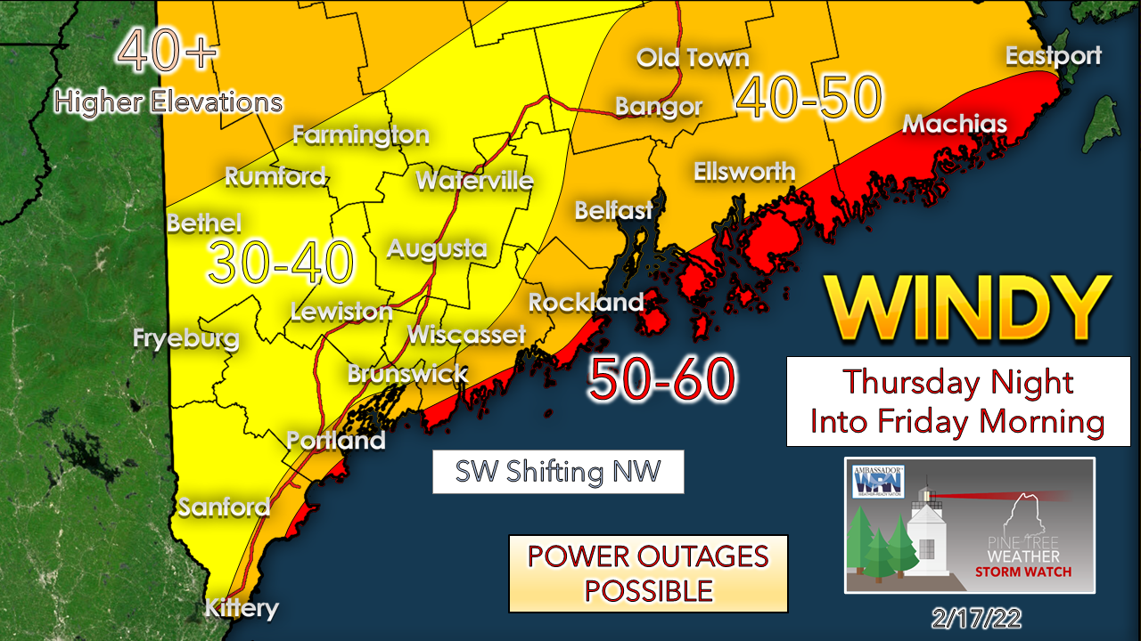 Wind is the main story for the coastal plain Thursday night into Friday. Strong southwest winds favor greater impacts for power outage potential for MidCoast and eastern areas. After the passage of the front, northwesterly winds in the 25-35 mph range continue through Friday, settling down Friday night. It would be wise to keep phones charged and have generators on the ready in case of power loss. 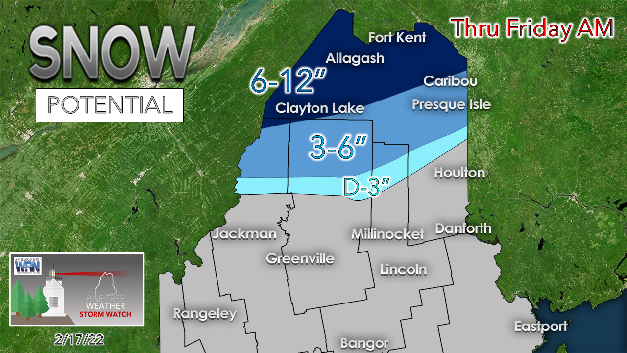 The far north sees the most snow from this event. There could be a sharp gradient cut off pending on the timing of the passage of the frontal boundary. Higher accumulations favor northwest Aroostook where a winter storm warning is posted.  Temperatures and outlook through TuesdayHigh temperatures for Friday are established in the wee hours then crash during the day, and a northwesterly wind adds wind chill to the air. A weak clipper system brings snow showers to the region for Saturday. High pressure controls the day on Sunday, with slightly warmer temps. Monday sees temperatures rise once again as mild air moves in from the southwest. Another long wave front brings rain for most Tuesday into Wednesday. 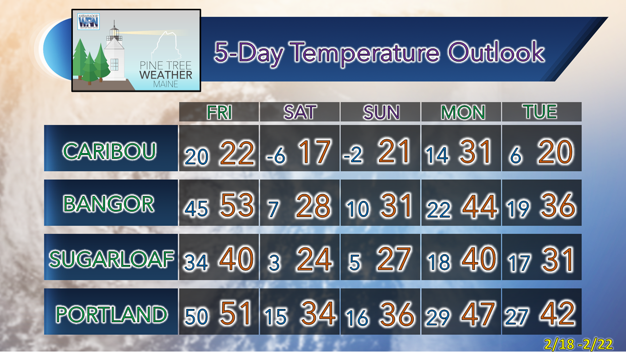 Join CoCoRaHS! Ever wanted to take rain or snow measurements? Join CoCoRaHS or the Community Collaborative Rain, Hail, and Snow Network. This volunteer network of observers measures precipitation from their backyards. Any age can volunteer. Data is used by NWS meteorologists to help with forecasts. For more information ► www.cocorahs.org Be prepared to receive alerts and stay updated!
 For more information in between posts, please follow Pine Tree Weather on Facebook and Twitter. Thank you for supporting this community-based weather information source which operates by reader supported financial contributions. Thank you as always for your support! - Mike NOTE: The forecast information depicted on this platform is for general information purposes only for the public and is not designed or intended for commercial use. For those seeking pinpoint weather information for business operations should use a private sector source. For information about where to find commercial forecasters to assist your business, please message me and I will be happy to help you. |

Mike Haggett
|