Pine Tree Weather
  • DISCUSSIONS
  • DONATE
  • WEATHER WALL
  • MAPS
  • RAIN OUTLOOK
  • SEVERE
  • MARINE
  • CPC OUTLOOK
  • Kennebunk
  • MY BIO
  • PTW IN MEDIA
  • OBSERVING WEATHER
  • INTERNSHIPS
  • INTERN ALUMNI
  • DISCUSSIONS
  • DONATE
  • WEATHER WALL
  • MAPS
  • RAIN OUTLOOK
  • SEVERE
  • MARINE
  • CPC OUTLOOK
  • Kennebunk
  • MY BIO
  • PTW IN MEDIA
  • OBSERVING WEATHER
  • INTERNSHIPS
  • INTERN ALUMNI

A stormy Monday; unsettled midweek into Thanksgiving

11/23/2020

Comments


A raw, damp, and windy Monday

Picture
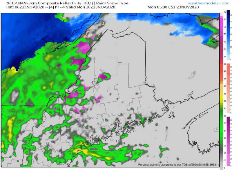
Low pressure intensifies as it heads into Atlantic Canada for Monday. Snow / mixed precipitation in the north and mountains to start off changes to rain before flipping back to snow as precipitation ends early this evening.

For the coastal plain, this appears to be mainly a rain event, but I can't rule out a few flakes as the low hauls down cold air on the backside. A rumble of thunder is possible, with the best chance of that for the MidCoast and DownEast areas. 

All areas see steady precipitation clear out by late afternoon south and west, and by 7-8 PM north and east.

Snow showers are expected to continue for the western mountains overnight into Tuesday. 
Picture
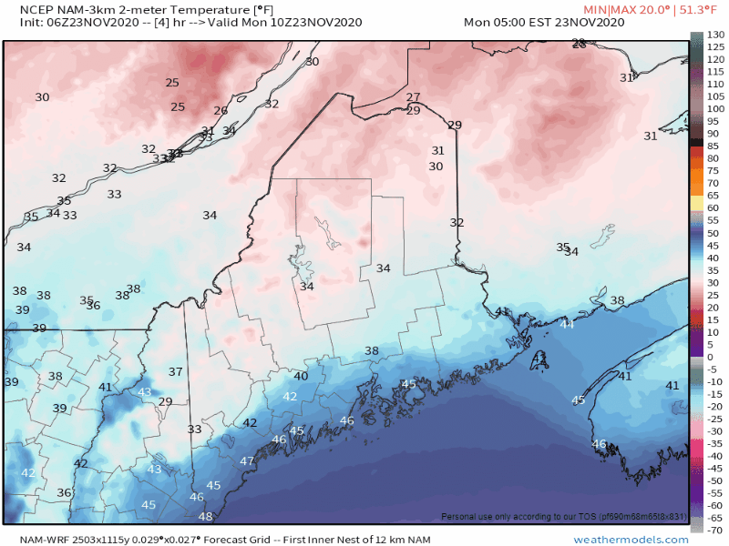
With the abundance of rainfall ( ½-1½+ ) and falling temperatures sets up a potential for flash freeze and icy roads this evening into the overnight. All areas wake up below freezing to start Tuesday. 
Picture
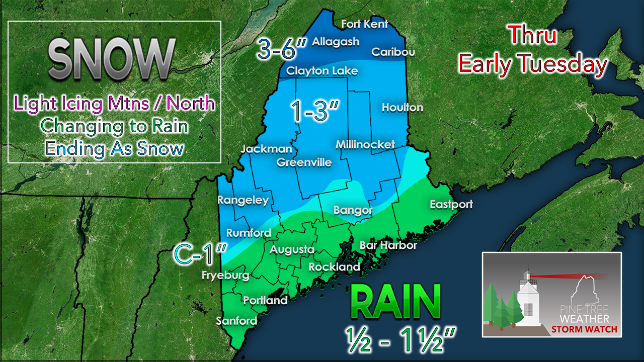
A slight adjustment to the precipitation map based on the latest forecast trends. Higher elevations in the west and areas to the north see more frozen precipitation. Some areas along the coastal plain may see 2" of rain from this event. The north and mountains should watch out for pockets of freezing rain which may slick the roads up, on top of the snow. 
Picture
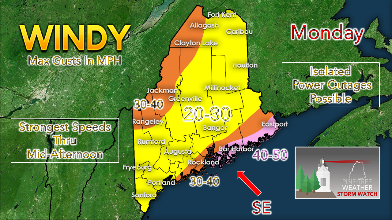
No real changes to the wind idea. The best chance for power outages will be for MidCoast, DownEast and the mountains. On the backside of the storm, the wind shifts to the northwest. With the storm intensifying in its departure, expect gusts in the 25-35 mph range through Tuesday afternoon, before settling Tuesday night into early Wednesday. 

Picture

Outlook through Thanksgiving

Picture
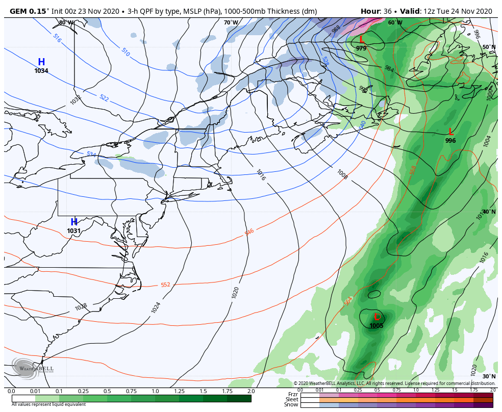
Snow showers persist in the mountains Tuesday until the wind drops. High pressure passes through overnight Tuesday. A weak disturbance on the backside of the high may bring some snow shower activity on Wednesday, but no accumulation of concern is expected. On the heels of that, a longwave frontal boundary could bring snow and/or a wintry mix to start Thanksgiving morning for interior areas, and rain for the shorelines. Confidence is good for precipitation, but who gets what for how long is still to be determined. Interior areas can anticipate potential for icy conditions Thanksgiving Day.

Temperature outlook through Sunday
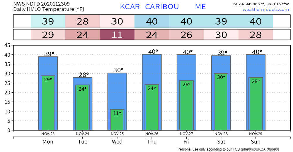
Picture
Picture
Picture
Picture

Winter precipitation types

Picture
Will there be rain, ice or snow? This graphic explains how having different layers of warm and cold air between the clouds and the ground determines the type of precipitation that hits the ground. nssl.noaa.gov/education/svrwx101/winter/types/

Be prepared to receive alerts and stay updated!

Picture
​​BE PREPARED WITH A NOAA Weather Radio.

​For $20-$40, it could provide important information to you when you need it. The weather bands are standard on most public safety scanners, and newer scanner models. Weather radios can be programmed for auto alert.  Click here for more information.

​​​► ► For the latest official forecasts, bulletins and advisories, please check in with the National Weather Service in Gray for western and southern areas, or Caribou for northern and eastern parts of Maine
Picture

For more information, please follow Pine Tree Weather on Facebook and Twitter. 

** FUNDING NEEDED FOR 2021 **
​Thank you for supporting this community based weather information source that is funded by your financial contributions. 


Stay updated, stay on alert, and stay safe!

​- Mike
Comments
    Picture

    Mike Haggett
    Kennebunk, ME

    Weather-Ready Nation
    Ambassador

    Certified Weather
    Forecaster
    Penn State '21

    American Meteorological Society

    National Weather Association
    ​
    ​SKYWARN-CWOP

    Matthew 19:26


    DONATE

    Picture
    Picture
    Picture
    Picture
    Picture

    Picture

    Picture

    Picture

    Picture

    Picture

    Picture

    Picture

    Picture

    Picture

    Picture

    Picture

    Picture


    Archives

    April 2025
    March 2025
    February 2025
    January 2025
    December 2024
    November 2024
    October 2024
    September 2024
    August 2024
    July 2024
    June 2024
    May 2024
    April 2024
    March 2024
    February 2024
    January 2024
    December 2023
    November 2023
    October 2023
    September 2023
    August 2023
    July 2023
    June 2023
    May 2023
    April 2023
    March 2023
    February 2023
    January 2023
    December 2022
    November 2022
    October 2022
    September 2022
    August 2022
    July 2022
    June 2022
    May 2022
    April 2022
    March 2022
    February 2022
    January 2022
    December 2021
    November 2021
    October 2021
    September 2021
    August 2021
    July 2021
    June 2021
    May 2021
    April 2021
    March 2021
    February 2021
    January 2021
    December 2020
    November 2020
    October 2020
    September 2020
    August 2020
    July 2020
    June 2020
    May 2020
    April 2020
    March 2020
    February 2020
    January 2020
    December 2019
    November 2019
    October 2019
    September 2019
    August 2019
    July 2019
    June 2019
    May 2019
    April 2019
    March 2019
    February 2019
    January 2019
    December 2018
    November 2018
    October 2018
    September 2018
    August 2018
    July 2018
    June 2018
    May 2018
    April 2018
    March 2018
    February 2018
    January 2018
    December 2017
    November 2017
    October 2017

Proudly powered by Weebly