Pine Tree Weather
  • DISCUSSIONS
  • DONATE
  • WEATHER WALL
  • MAPS
  • RAIN OUTLOOK
  • SEVERE
  • MARINE
  • CPC OUTLOOK
  • Kennebunk
  • MY BIO
  • PTW IN MEDIA
  • OBSERVING WEATHER
  • INTERNSHIPS
  • INTERN ALUMNI
  • DISCUSSIONS
  • DONATE
  • WEATHER WALL
  • MAPS
  • RAIN OUTLOOK
  • SEVERE
  • MARINE
  • CPC OUTLOOK
  • Kennebunk
  • MY BIO
  • PTW IN MEDIA
  • OBSERVING WEATHER
  • INTERNSHIPS
  • INTERN ALUMNI

A taste of mid-summer before a trip backwards to mid-April

6/1/2023

Comments


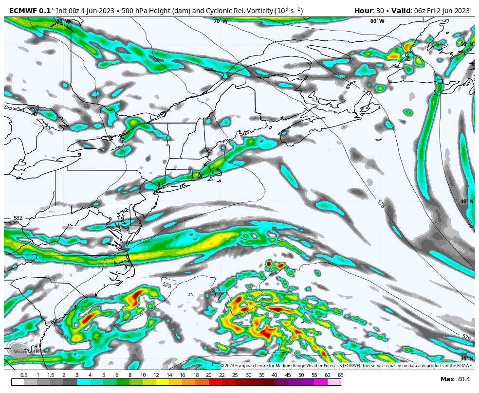
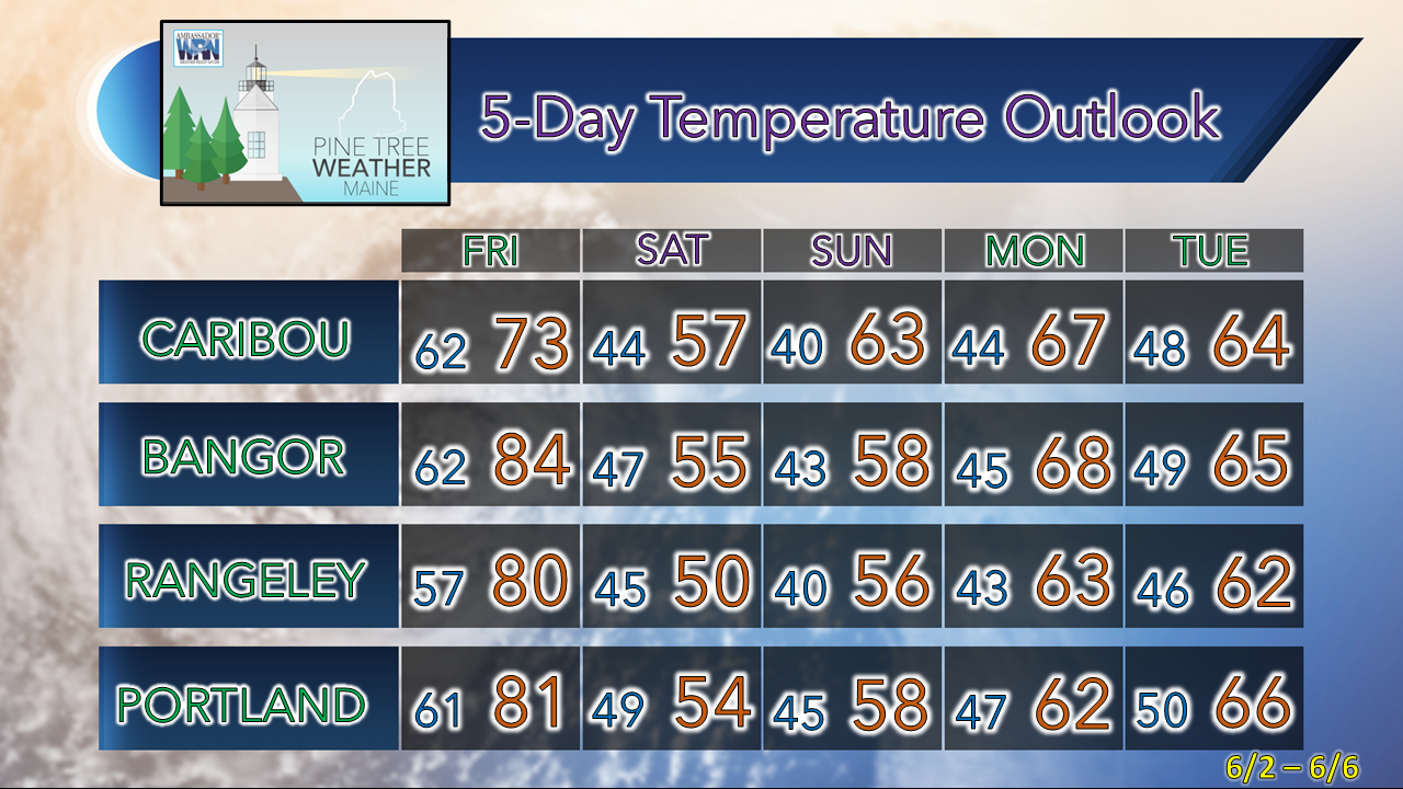
Record highs possible for northern areas

Picture
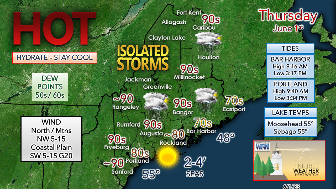
June 1st is the start of meteorological summer, and it will feel that way across interior Maine. While it will be hot, the humidity appears to be nominal. Where the dew points rise into the 60s appear primarily along the coastal plain, thanks to a southwest wind direction that brings in moisture off the ocean. For those fortunate to have the day off, the tides are running perfect for plenty of room at the seaside beaches in the afternoon to escape the heat.

A new record high was established in Caribou on Wednesday. There is a good chance new record highs could be established or tied in several of the long-term observation sites. With overnight lows being warm at the high end, some new records for minimum maximums are possible as well.

With the warmth comes the threat of isolated thunderstorms in the afternoon into the overnight...
Picture
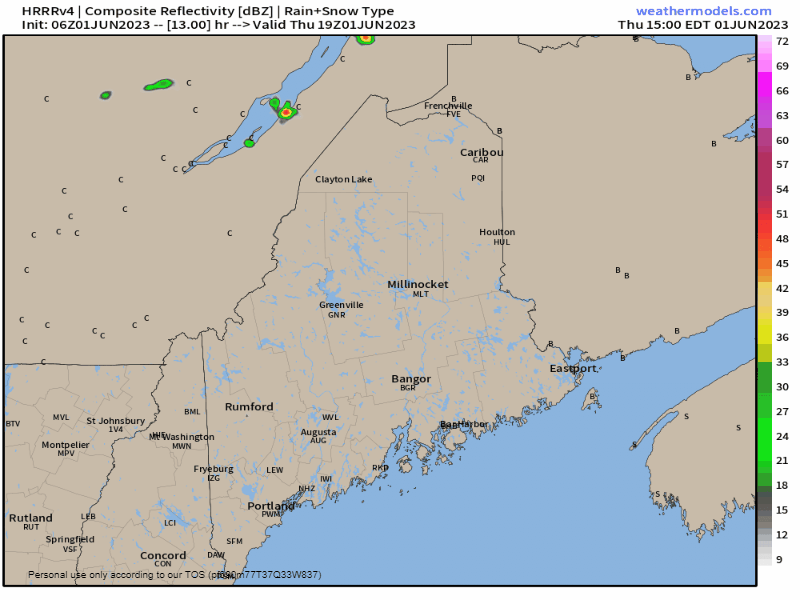
Thursday 3 PM to Friday 6 AM - Any showers or storms that pop are expected to be widely scattered in nature with the better chance over the north and east. The severe risk is minimal given the lack of wind shear. The atmosphere is also lacking moisture with the lower dew point values, which minimizes the downpour and flash flooding threat. Some areas could hear some overnight rumbles of thunder as the backdoor cold front approaches on Friday. 

More showers and storms on the way Friday

Picture
Friday 6 AM to Saturday 2 AM - Early morning showers and rumbles taper off and the sky begins to clear out over the southern two-thirds of the region. Heat will build up again with dew points rising up into the 60s over the south and west. With the front approaching, showers and storms are expected to be more widespread. The dynamics are favored for isolated severe storms, which may contain damaging wind, hail, and localized flash flooding from downpours. Guidance has been hinting at a slowdown of the frontal boundary as it heads towards the Gulf of Maine later in the day on Friday. That sets up potential for heavy rain showers to persist over southwestern areas Travel Friday evening could be a bit rough with the rain reducing visibility and the outside threat for strong to severe storms. 
Picture
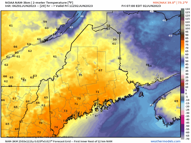
As the front descends into the region, temperatures are expected to crash. Expect a prolonged period of well below normal temperatures to begin starting on Saturday.

Blocking pattern to keep the region cool
​and unsettled into next week

Picture
A blocking ridge to the northeast and the northwest parks an upper-level low over the region and stays in the area for much of, if not all of, next week. This keeps temperatures down. Saturday and Sunday are likely to feel like mid-April with highs only in the 50s. This will also keep showers in the forecast as well as waves spin around the upper-low, along with a reinforcing charge to come from the northwest heading into midweek.

​The position of the upper low is critical here. Guidance is varied in both operational and ensemble ideas as to what happens with it.  The 12z European operational model from Wednesday tossed the idea out of a potential NorEaster to develop that potentially could drop a month's worth of rainfall over parts of the region. That idea was short lived, but ensembles still hint that the idea is still alive. I don't see how the upper-low doesn't spin a strong storm up out of it. It's a matter of where it goes, when it happens, and IF it brings impact to Maine.

Stay tuned!

Temperature outlook through Tuesday

Picture

Pine Tree Weather is funded from followers like you.
I would appreciate your financial support. 
Click here for how you can contribute.


You may not like the weather, but I hope you like what I do! Please hit the like button
​on Twitter and Facebook, and share!

I sincerely appreciate your support!

Stay updated, stay on alert, and stay safe!

- Mike

​NOTE: The forecast information depicted on this platform is for general information purposes only for the public and is not designed or intended for commercial use. For those seeking pinpoint weather information for business operations, you should use a private sector source. For information about where to find commercial forecasters to assist your business, please message me and I will be happy to help you.

Comments
    Picture

    Mike Haggett
    Kennebunk, ME

    Weather-Ready Nation
    Ambassador

    Certified Weather
    Forecaster
    Penn State '21

    American Meteorological Society

    National Weather Association
    ​
    ​SKYWARN-CWOP

    Matthew 19:26


    Picture

    Jenna Gurtz
    Buffalo Grove, IL

    B.A. Atmospheric Science
    & Meteorology

    Campus Weather Service
    ​
    ​Penn State '25


    Picture

    Trey Austin
    Raleigh, NC

    Atmospheric Science 
    & Meteorology

    Environmental Science

    NC State '26


    Picture

    Harry Fuess
    East Lansing, MI

    Atmospheric
    ​& Climate Science

    Quantitative Data Analytics

    Michigan State '26


    Picture

    Daniel Weaver
    North Wales, PA

    Atmospheric Science 
    & Meteorology

    History

    Campus Weather Service

    ​Penn State '26


    DONATE

    Picture
    Picture
    Picture
    Picture
    Picture

    Picture

    Picture

    Picture

    Picture

    Picture

    Picture

    Picture

    Picture

    Picture

    Picture

    Picture

    Picture


    Archives

    June 2025
    May 2025
    April 2025
    March 2025
    February 2025
    January 2025
    December 2024
    November 2024
    October 2024
    September 2024
    August 2024
    July 2024
    June 2024
    May 2024
    April 2024
    March 2024
    February 2024
    January 2024
    December 2023
    November 2023
    October 2023
    September 2023
    August 2023
    July 2023
    June 2023
    May 2023
    April 2023
    March 2023
    February 2023
    January 2023
    December 2022
    November 2022
    October 2022
    September 2022
    August 2022
    July 2022
    June 2022
    May 2022
    April 2022
    March 2022
    February 2022
    January 2022
    December 2021
    November 2021
    October 2021
    September 2021
    August 2021
    July 2021
    June 2021
    May 2021
    April 2021
    March 2021
    February 2021
    January 2021
    December 2020
    November 2020
    October 2020
    September 2020
    August 2020
    July 2020
    June 2020
    May 2020
    April 2020
    March 2020
    February 2020
    January 2020
    December 2019
    November 2019
    October 2019
    September 2019
    August 2019
    July 2019
    June 2019
    May 2019
    April 2019
    March 2019
    February 2019
    January 2019
    December 2018
    November 2018
    October 2018
    September 2018
    August 2018
    July 2018
    June 2018
    May 2018
    April 2018
    March 2018
    February 2018
    January 2018
    December 2017
    November 2017
    October 2017

Proudly powered by Weebly