Heat and humidity continue Friday Thursday night appears to be mild once again with temperatures only dropping into the mid-60s for most, with coastal areas dropping into the high 50s to low 60s. Fog will develop once again, especially in areas along the coast and neighboring inland towns. Spotty drizzle is also possible for those areas. On Friday, the warmth and mugginess continue with temperatures in the upper 70s and reaching well into the 80s statewide. Combining this with dewpoint values in the 70s, this will produce heat indices in the lower to mid-90s for some areas, specifically in southwest interior Maine. This high heat and humidity will make for extremely uncomfortable conditions and allow for increased instability during daytime hours. Otherwise, expect a mix of sun and clouds. Thunderstorms return Friday afternoon A frontal system will slowly track across the state during the day on Friday. This cold front will initiate showers and thunderstorms for the afternoon hours. Strong storms may accompany this frontal passage leading to gusty winds and locally heavy rainfall. There is the possibility that some of the storms could become severe, especially towards the afternoon when storms are in southern and eastern Maine. The front will move offshore Friday evening with showers and any thunderstorms across DownEast areas diminishing. Unsettled weather continues over the weekend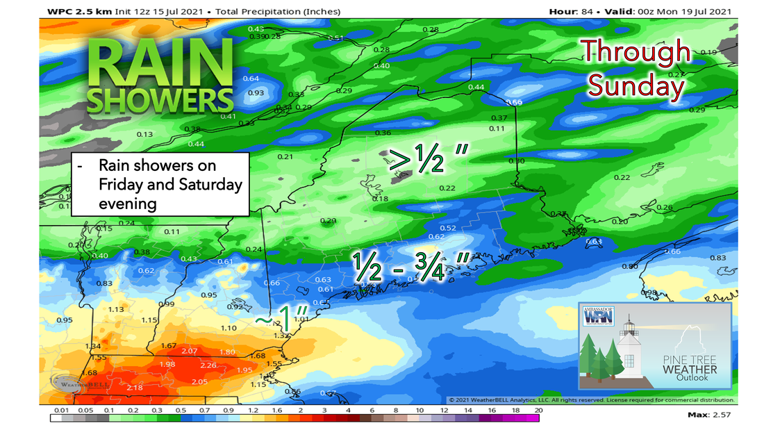 An unsettled pattern will be in place this weekend. Showers and thunderstorms will be possible once again on Saturday, specifically during the evening and overnight hours into Sunday. Temperatures will be warm, but not as hot as Friday due to the thicker cloud cover. Most areas on Saturday will see high temperatures in the mid to upper 70s with some areas to the North and West possibly seeing 80°F due to less cloud cover during the day. Clouds increase Saturday afternoon, with a steady rainfall arriving overnight. Saturday night and Sunday’s weather will depend on where the frontal boundary stalls out and how far north any moisture gets with any waves moving along it. Models are in disagreement currently on exact timing, amounts, and location of significant rainfall but right now it’s looking like Southwest Maine and along the coast will see the highest precipitation amounts through the weekend. Rain showers and clouds slowly diminish Sunday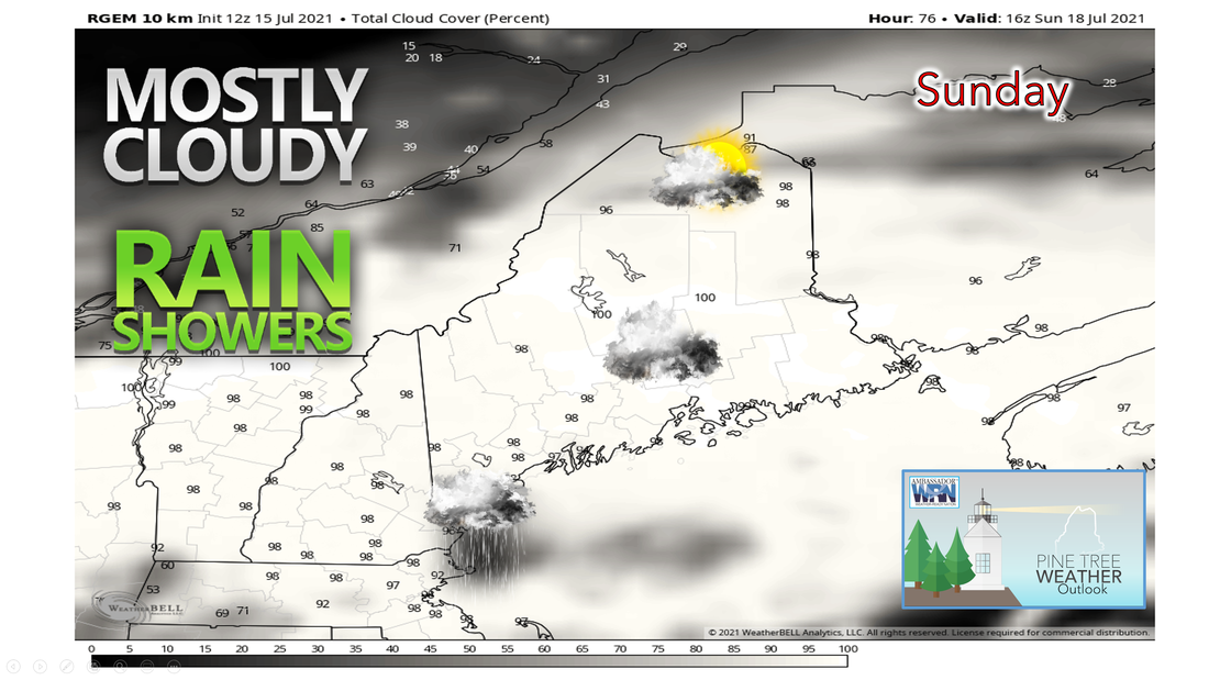 As mentioned earlier, Sunday’s weather will depend on how fast or slow the system moves through during the overnight hours from Saturday into Sunday. There still exists some uncertainty in where the area of low pressure will be located and thus it is possible the extent of the rain could extend farther south or north. Sunday will start with showers and periods of rain, and a very slow clearing trend takes place over the course of the day. Conditions should be drier aside from the occasional shower. Mostly cloudy skies will dominate across much of the area on Sunday with locations farther north seeing possible breaks in the sky. Temperatures should be in the 80s and upper 70s. Beginning of the next workweek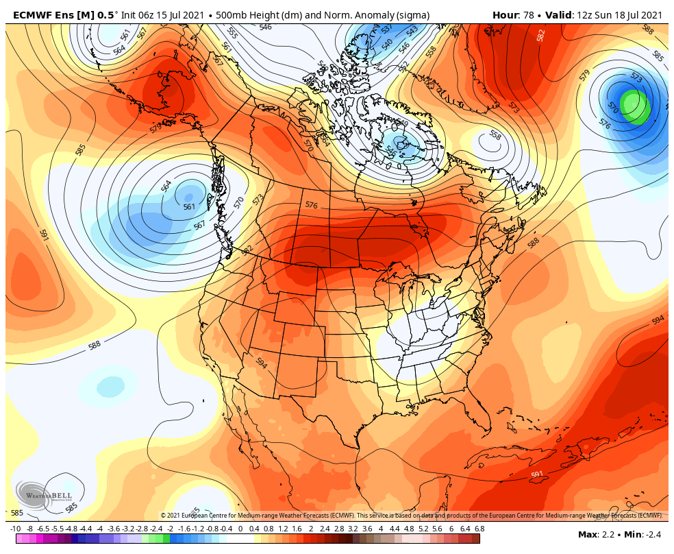 Unsettled weather looks to continue into the middle of next week in advance of an approaching upper trough with the chance for showers. Temperatures through early next week will tend to average a bit above normal and then near normal by mid-week. Meanwhile, a heatwave continues from the northern Great Basin to the northern Rockies/northern Plains. Drought Monitor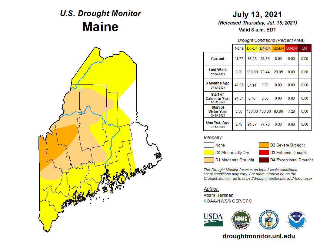 Currently, most of us are still suffering from abnormally dry conditions. The worst of it is in far western Maine in Oxford, Franklin, and Somerset counties which are under level D2, classified as severe drought. Everyone else is under moderate drought or abnormally dry conditions. Southeastern Aroostook and eastern Washington counties are not experiencing any form of drought at this time. Last week's rain from Tropical Storm Elsa helped decrease the drought levels statewide but most are still experiencing dry conditions. Our unsettled pattern continues next week with more chances for showers and thunderstorms. Temperatures will also remain a bit above average to near average through midweek. Temperature outlook through late JulyThe plots below show the trend of the high and low temperatures for Carrabassett, Bangor, Caribou, and Portland over the next week and a half. Temperatures through early next week will remain close to near average most days. Chances of isolated showers continue into the next workweek. 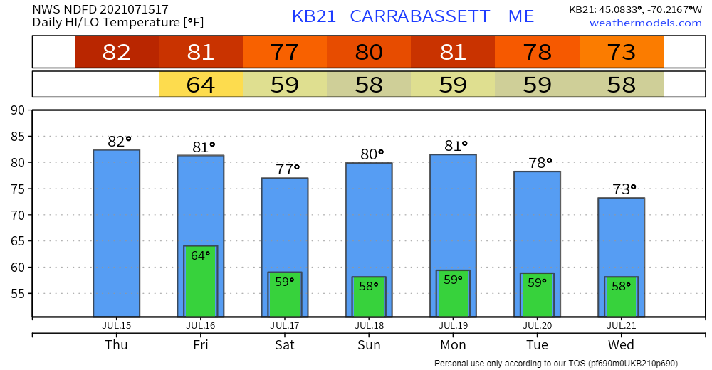 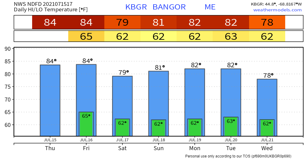 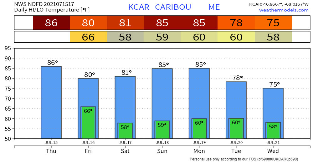 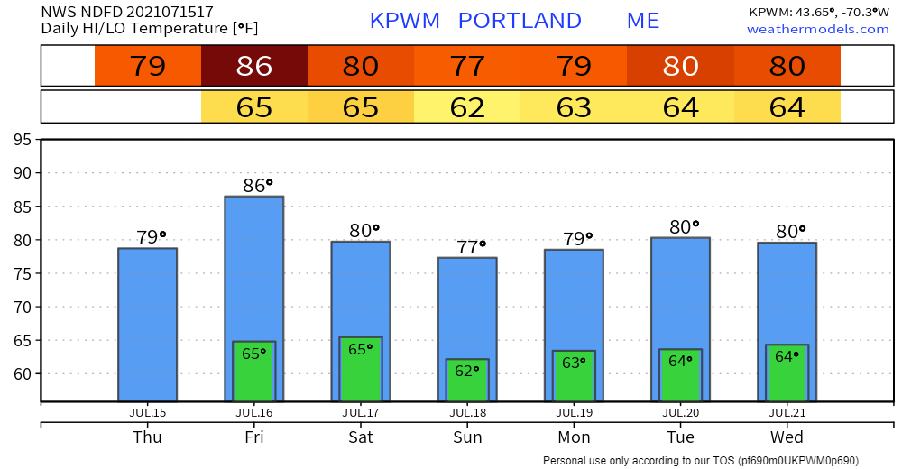 Hurricane Preparedness - Get an Insurance Checkup Today, call your insurance company or agent and ask for an insurance checkup to make sure you have enough homeowner's insurance to repair or even replace your home...and remember, standard homeowners' insurance doesn’t cover flooding. Whether you’re a homeowner or renter, you’ll need a separate policy for flooding. floodsmart.gov. Act now as flood insurance requires a 30-day waiting period. Be prepared to receive alerts and stay updated!
For more information in between posts, please follow Pine Tree Weather on Facebook and Twitter.
Thank you for supporting this community-based weather information source which operates by reader supported financial contributions. Stay updated, stay on alert, and stay safe! |

Mike Haggett
|