
Warmth with isolated showers Wednesday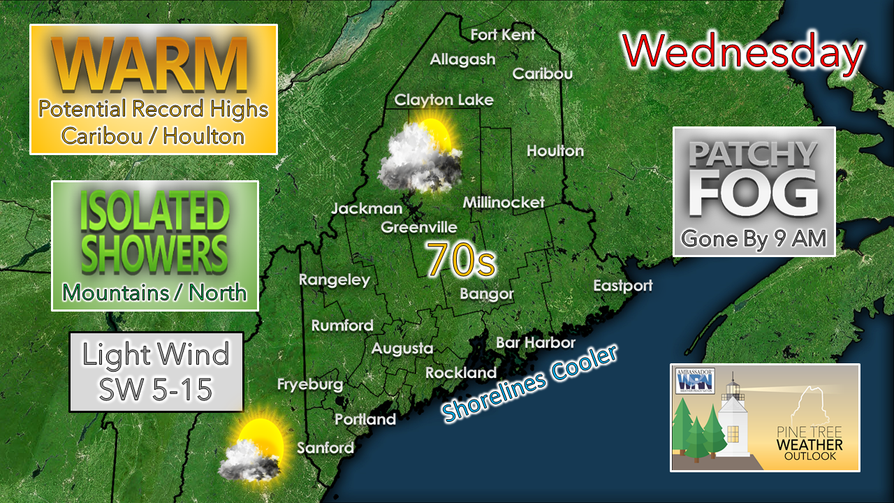 This incredible stretch of weather for Maine continues for one more day. Any areas of patchy fog should clear off by mid-morning. A weak shortwave may bring a few more clouds than Tuesday, but temperatures nudge a bit higher in combination of the upper-level ridge to the west and a southwesterly surface air flow. Record highs are possible in Caribou (73° in 1943) and Houlton (75° in 1954) as the mercury continues to run 15-20° above daily average. Shorelines for MidCoast and DownEast areas will be cooler as the air off the ocean keeps the daily highs in the mid to upper 60s. 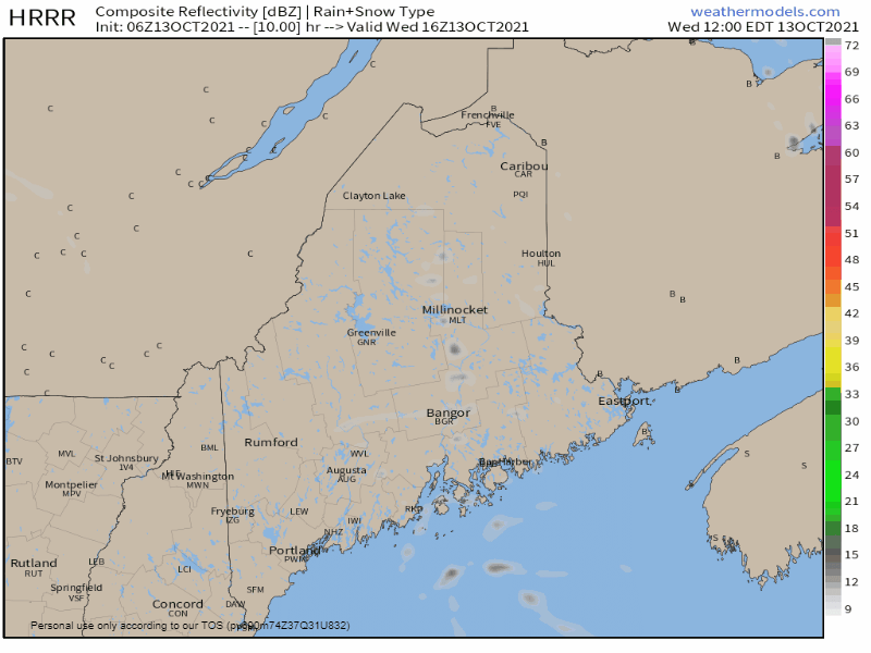 Wednesday Noon - Thursday Midnight: The aforementioned shortwave may trigger some isolated showers primarily over the mountains and north for the afternoon into the evening. I can't rule out potential for a sprinkle or light shower for southern and eastern areas as the weak frontal boundary passes through. Shower activity is expected to end by late evening. Expect areas of patchy fog to emerge overnight into Thursday morning. Driving in Patchy Fog Driving in fog can be dangerous. Be on the lookout for sudden changes in visibility. The patchy nature of fog can lower visibility quickly and unexpectedly, especially if you are driving fast, so be sure to slow down. Visibility may also be lower near rivers. weather.gov/safety/fog Showers and cooler temps on the way for the weekend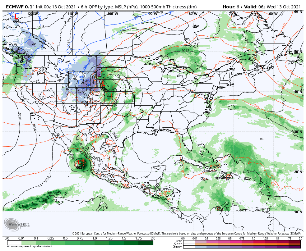 Wednesday 2 AM - Sunday 8 PM: The pattern becomes more active heading into the remainder of the week. Note the Colorado Low which is dumping snow over the Rockies and associated frontal boundary that drags Hurricane Pamela over the eastern Pacific into the Midwest. The energy associated with that storm could play a factor in how the weekend plays out as it rides along the frontal boundary and a new area of low pressure ignites along it Friday and rapidly intensifies as it races towards northern Quebec and drags a longwave cold front into the region for the weekend. At this point, the mountains and north appear to receive the most rainfall, which is desperately needed in those areas. Isolated afternoon showers are expected to be in forecast for southern areas Friday and become scattered to the entire state on Saturday. The front slides through Saturday night into early Sunday bringing the best chance for rain for all. Scattered showers may persist into Sunday as a secondary area of low pressure may form along the front as it heads into eastern Canada. Temperatures cool off behind the front to start next week. 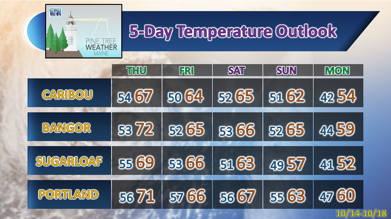 Current deficit for 2022 - $2,000 |

| | BE PREPARED WITH A NOAA Weather Radio. For $20-$40, it could provide vital information to you when you need it. The weather bands are standard on most public safety scanners, and newer scanner models. Weather radios can be programmed for auto alert. Click here for more information. |
| ► ► For the latest official forecasts, bulletins, and advisories, please check in with the National Weather Service in Gray for western and southern areas, or Caribou for northern and eastern parts of Maine. |  |

Thank you for supporting this community-based weather information source which operates by reader supported financial contributions.
Stay updated, stay on alert, and stay safe!
- Mike

Mike Haggett
Kennebunk, ME
Weather-Ready Nation
Ambassador
Certified Weather
Forecaster
Penn State '21
American Meteorological Society
National Weather Association
SKYWARN-CWOP
Matthew 19:26
Please
Support
Pine Tree Weather
In 2024


Archives
July 2024
June 2024
May 2024
April 2024
March 2024
February 2024
January 2024
December 2023
November 2023
October 2023
September 2023
August 2023
July 2023
June 2023
May 2023
April 2023
March 2023
February 2023
January 2023
December 2022
November 2022
October 2022
September 2022
August 2022
July 2022
June 2022
May 2022
April 2022
March 2022
February 2022
January 2022
December 2021
November 2021
October 2021
September 2021
August 2021
July 2021
June 2021
May 2021
April 2021
March 2021
February 2021
January 2021
December 2020
November 2020
October 2020
September 2020
August 2020
July 2020
June 2020
May 2020
April 2020
March 2020
February 2020
January 2020
December 2019
November 2019
October 2019
September 2019
August 2019
July 2019
June 2019
May 2019
April 2019
March 2019
February 2019
January 2019
December 2018
November 2018
October 2018
September 2018
August 2018
July 2018
June 2018
May 2018
April 2018
March 2018
February 2018
January 2018
December 2017
November 2017
October 2017