Mainly dry for Thursday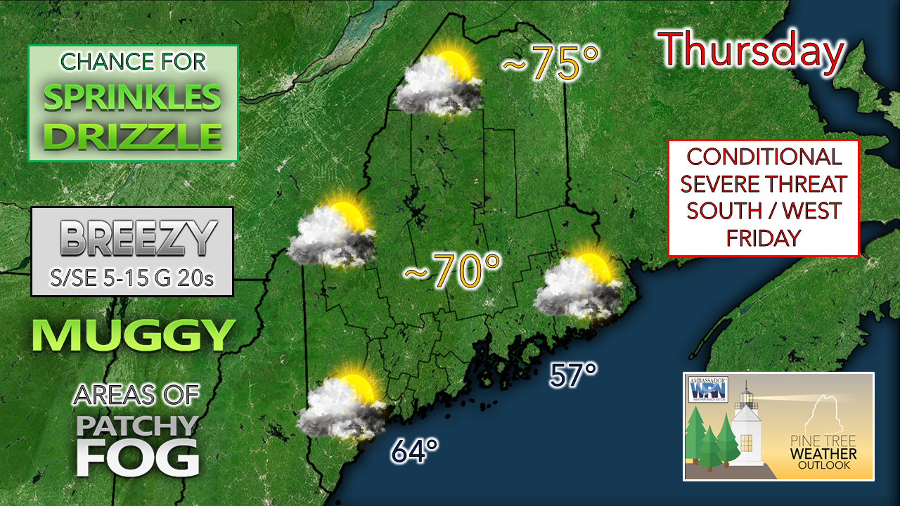 No real changes to the forecast for Thursday that was expressed here and on Facebook Wednesday. The sun may poke out periodically. With the elevated humidity and southeast flow off the water, I suspect the shorelines may deal with areas of fog and pockets of drizzle off and on through the day. The north and mountains may see a sprinkle or a light shower heading into the afternoon into the evening. Temperatures range in the 70s for most, warmest north, with 60s the likely high mark for the shorelines. Rain arrives Friday For the morning hours of Friday, expect areas of fog, pockets of drizzle and scattered showers around the region. The frontal boundary approaches from the west in the afternoon, which will increase rain chances through Friday night into early Saturday morning. As I mentioned Wednesday, there is a conditional threat for severe storms. 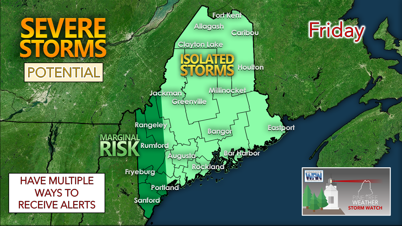 The main concern is for western and southern areas in the marginal risk area. Timing of the arrival of the potentially convective activity in conjunction with cloud cover will dictate storm potential. 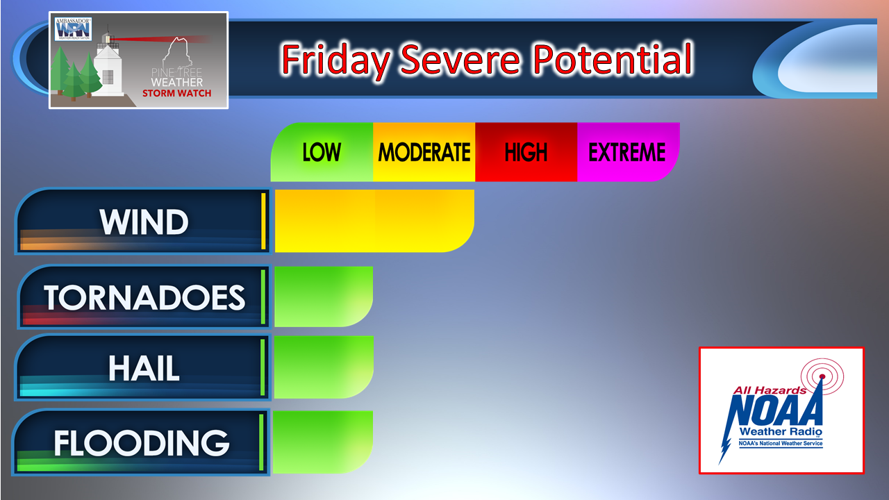 From Storm Prediction Center's Day 2 Outlook (time sensitive link): Day 2 Convective Outlook NWS Storm Prediction Center Norman OK 1207 AM CDT Thu Sep 23 2021 Valid 241200Z - 251200Z ...THERE IS A MARGINAL RISK OF SEVERE THUNDERSTORMS OVER A PORTION OF NEW ENGLAND... ...SUMMARY... A few severe thunderstorms with strong wind gusts and a couple of tornadoes may impact a portion of New England Friday. ...New England... A cutoff upper low currently situated over the OH Valley will begin to accelerate northward Friday and be situated over the lower Great Lakes Friday morning. This feature will continue into Ontario and Quebec during the day. A front will extend from an occluded low over Ontario, southeast into New England by 12Z Friday and will advance slowly east through the period. A moist pre-frontal warm sector with surface dewpoints in the mid to upper 60s F will be in place across New England. However, widespread clouds and ongoing bands of showers and thunderstorms along the warm conveyor belt will limit substantial boundary layer destabilization. Nevertheless, at least marginal surface-based instability will exist with MLCAPE from 400 to 800 J/kg. A 40-50 kt low-level jet coupled with up to 50 kt 500 mb winds resulting from a glancing influence of the ejecting shortwave trough will result in favorable wind profiles for organized storms. Up to 250 m2/s2 0-1 km storm relative helicity and 35-45 kt effective bulk shear will conditionally support a few embedded bowing segments and supercell structures. Will maintain the MRGL risk category with this outlook due to a potential limited thermodynamic environment. However, a SLGT risk upgrade may be warranted in later updates if it becomes apparent that instability will be sufficient for a more robust severe threat. Deciphering the scientific interpretation of this, the parameters for damaging wind and tornadoes are there. The best chance for this is for areas to the west and south of Maine given the projected timing. If the frontal boundary accelerates, that increase the chance for western and southern areas to see strong to severe activity. With sunset now before 7 PM, the severe threat begins to diminish into the late afternoon hours. The bottom line is that this is a wait and see scenario based on timing and cloud cover. 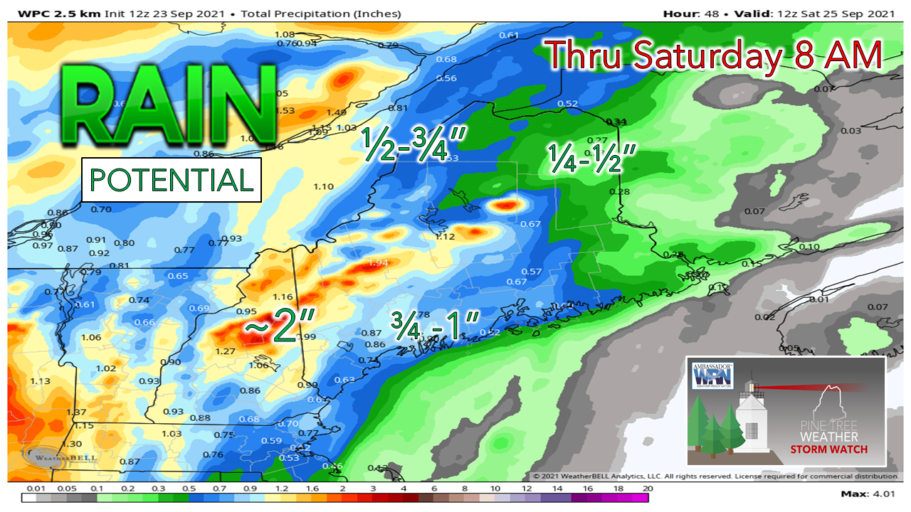 There is a solid chance here for a decent amount of rain for the region that needs it the most. With severe drought continuing to linger in the western mountains, 1-2" of rain appears to be a fair general idea. The wind flow favors more rain for the south and east facing slopes thanks to orographic lift. This may keep rain totals lower in the valleys north of the Bigelow's. Uncertainty to the forecast for Saturday and SundayWhile confidence is good through Friday, the rest of the weekend is questionable. The main question is does the frontal boundary stall or won't it. 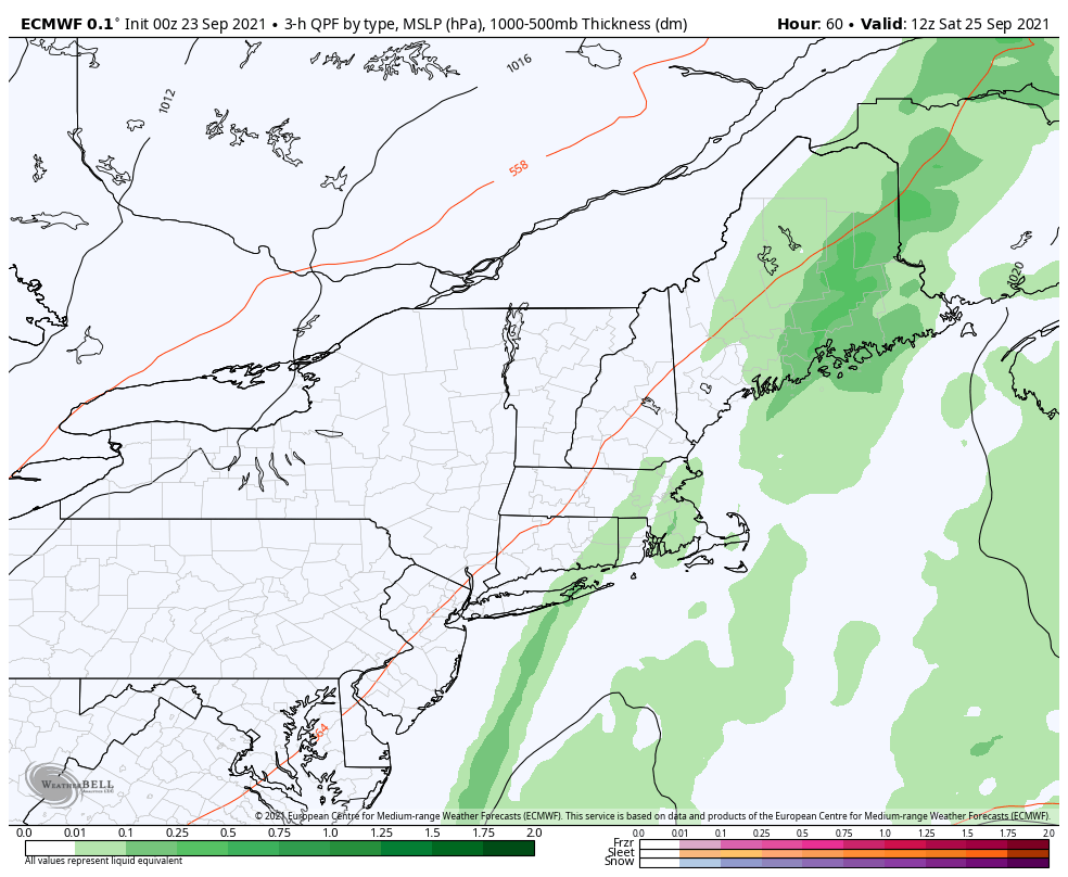 If the frontal boundary stalls, Saturday turns into a complete washout statewide, with showers for western and southern areas and heavy rain for northern and eastern areas for Sunday, clearing out Sunday night. Under this scenario, rain totals could double in amounts received by 8 AM Saturday by the time it wraps up. 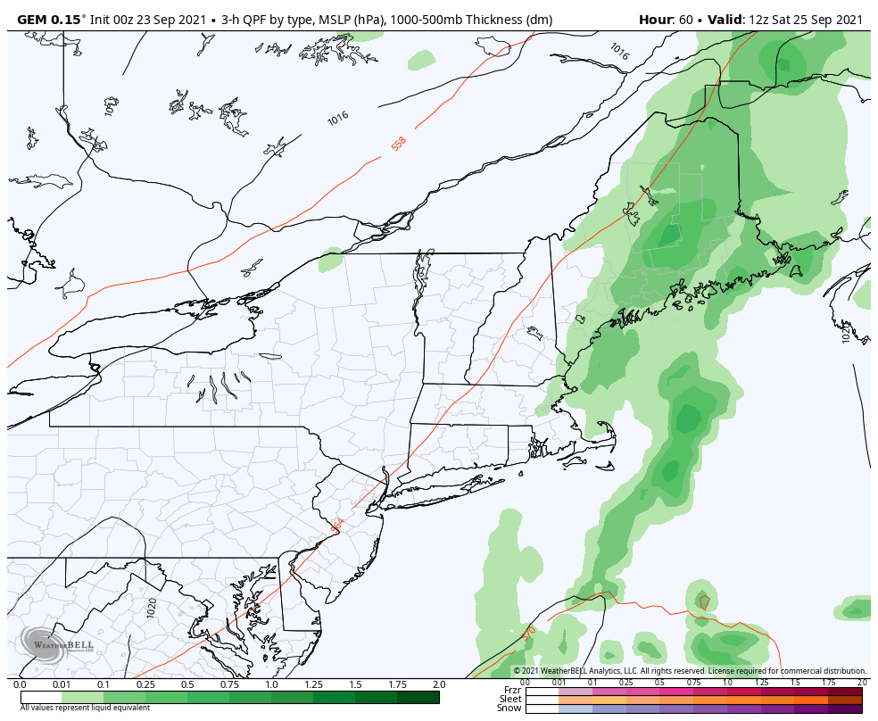 If the front is more progressive in departure, most of the accumulating rain shower activity stays east of Portland on Saturday. Low pressure over Hudson Bay drops to the southeast into central Quebec keep showers going primarily over northern and western areas into Sunday. Stay tuned for updates.  CoCoRaHS Ever wanted to take rain or snow measurements? Join CoCoRaHS or Community Collaborative Rain, Hail, and Snow Network. This volunteer network of observers measures precipitation from their backyards. Any age can volunteer. Data is used by NWS meteorologists to help with forecasts. www.cocorahs.org Outlook into early next weekOnce the rain clears out, humidity levels drop Sunday into Monday. Uncertainty in the forecast continues into early next week. A chance for rain exists for northern and western areas Monday and Tuesday for now. Temperatures continue to run well above normal through the period. 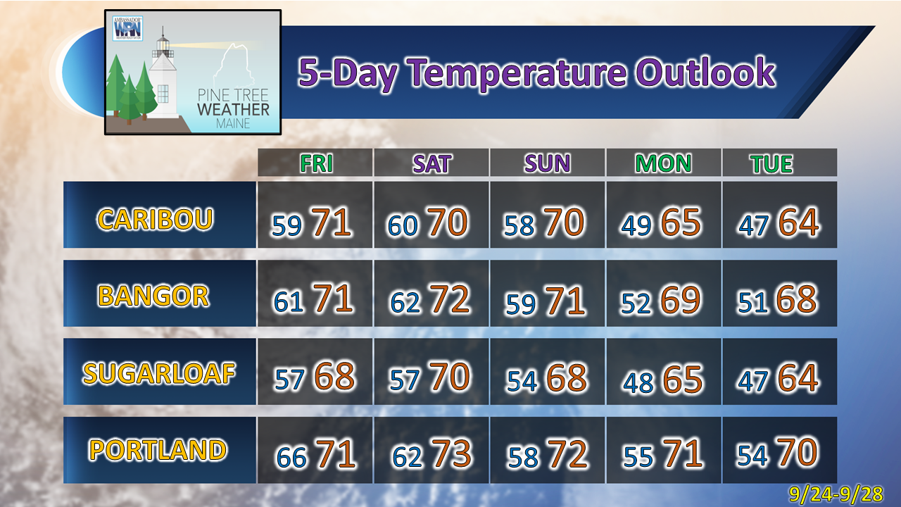 Be prepared to receive alerts and stay updated!
For more information in between posts, please follow Pine Tree Weather on Facebook and Twitter.
Thank you for supporting this community-based weather information source which operates by reader supported financial contributions. Stay updated, stay on alert, and stay safe! - Mike |

Mike Haggett
|