
All the pieces of the puzzle are on the table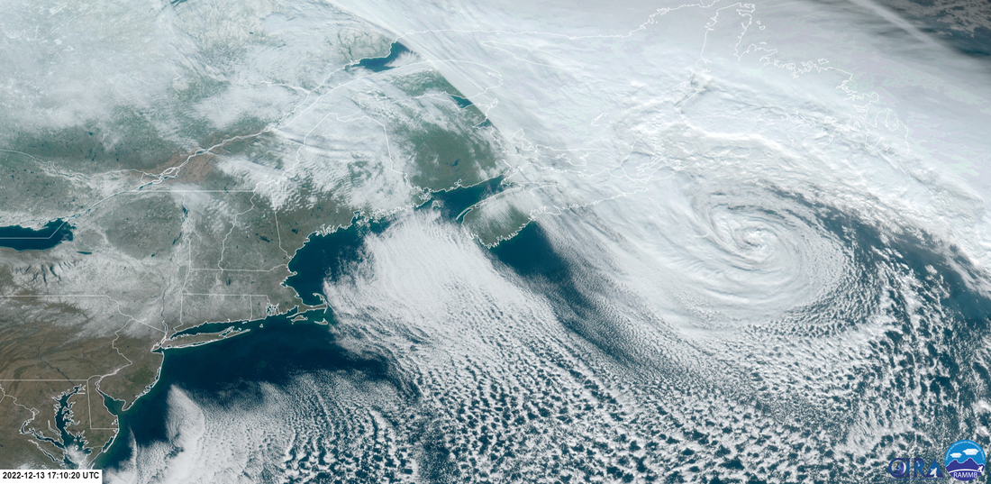 The frontal boundary that brought southwestern areas some light snow on Monday has blossomed into a formidable storm southeast of the Canadian Maritimes. The storm dumped upwards of a foot of snow over parts of Nova Scotia. It's in the process of weakening as it turns counterclockwise around Cape Breton, Prince Edward Island, then New Brunswick, and eventually over DownEast Maine Wednesday afternoon. For Maine concerns, this brings snow showers over northern and eastern areas Tuesday night into Wednesday morning, with scattered activity through the day with a few flakes possible over southern areas by Wednesday evening, along with gusty wind. 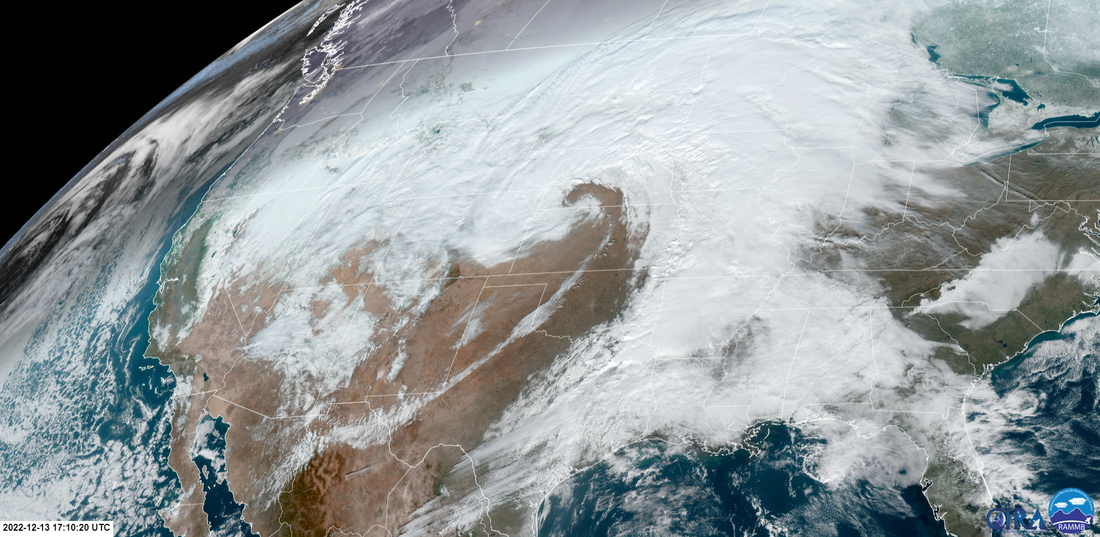 This is the upper-low over the central part of the country responsible for tornado activity over the deep south along with big snows and ice to the north which it will continue to produce as it moves to the east. 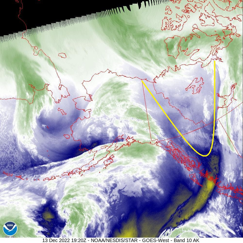 This is the kicker piece I have talked about for days now working through northwestern Canada. This piece steers the upper-low and drives the trough associated with it to a negative tilt and thus produces the Nor'easter to the south on Thursday. 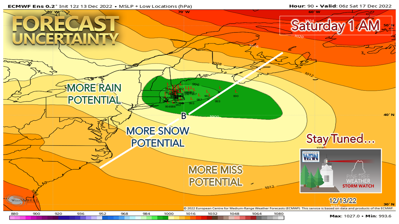 Ensemble ideas continue to cluster together to produce a coastal hugger. The questions remain at this point are the fine tuning of the track, the intensity of the low, how strong the wind, how warm will the coastal front be and how far inland it will go, how much precipitation and what the snow to water ratios (how wet the snow will be and how far inland the slop goes), and if a dry slot works in and ruins the accumulation party? You think forecasting is easy? 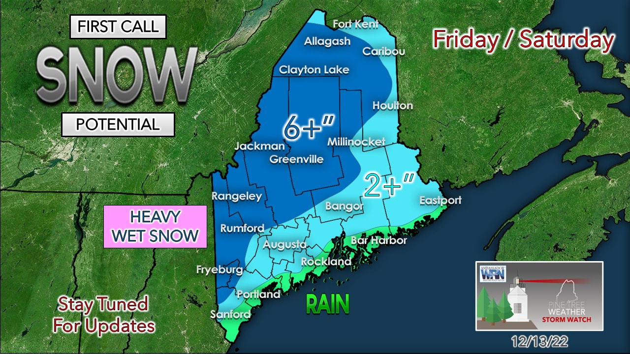 This idea I posted on the Facebook page and linked on Twitter to it Tuesday morning is where I hold serve at this point. Given the fact that there remains some uncertainty with the aforementioned questions I have, I am not going to rush to judgement any further than this. Bottom line is this is a plowable event for most away from the coast. The heavy wet snow could be problematic with wind for power loss. The good news in this is most areas are expected to rise above freezing on Saturday which will help get the snow off the trees as breezy conditions persist through Monday. 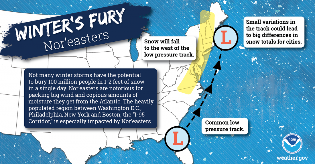 Wind advisory across 15 counties for Wednesday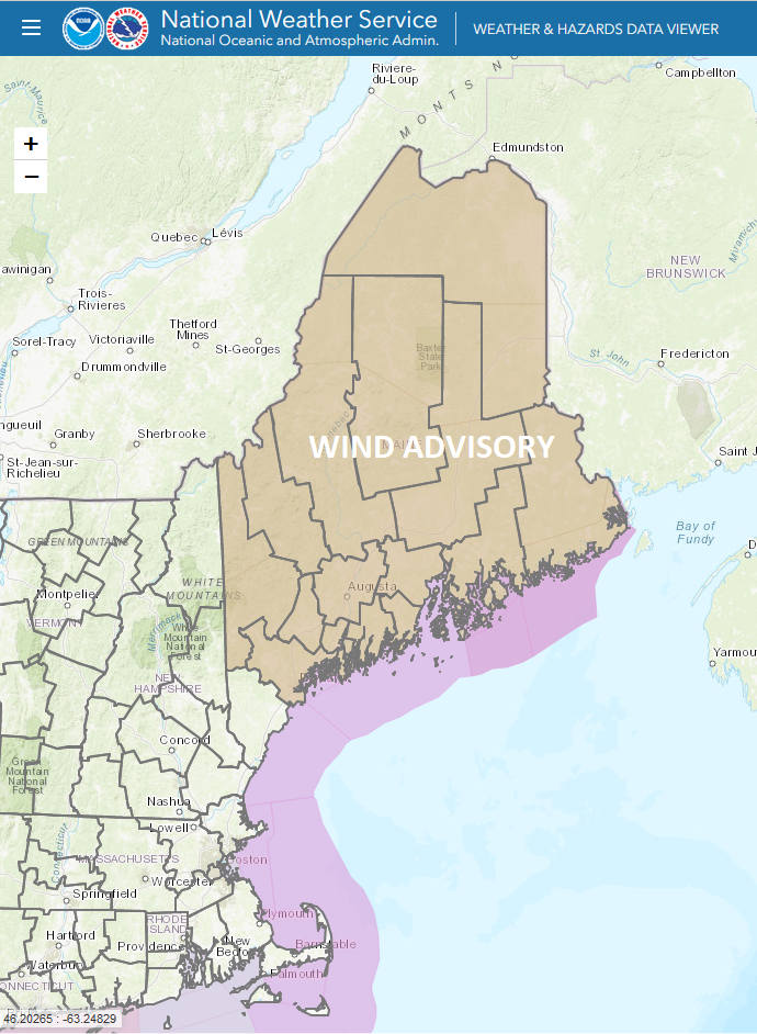 Both the Gray and Caribou National Weather Service offices have issued a wind advisory for all but York County for Wednesday as of the time of this post Tuesday afternoon. The wind advisory goes into effect Wednesday morning at 4 AM and ends at 4 PM for all locations. For York County, I declare a Flying Trash Can Alert day as I expect strong gusts there. It would be wise to secure all outdoor Christmas decorations, grill covers, and anything else you don't want to chase down the street or out in the Back Forty. Some spotty power outages are possible. Current deficit for 2023 = $1,250 ... please donate! Five day forecast through SundayWEDNESDAY WINDY CONDITIONS STATEWIDE SNOW SHOWERS OVERNIGHT TUESDAY INTO WEDNESDAY NORTH & EAST SLICK SPOTS POSSIBLE WEDNESDAY MORNING NORTH & EAST BLOWING SNOW POSSIBLE IN THE NORTH THROUGH THE DAY North & Mountains: Cloudy w/ chance of snow showers Northern areas may pick up 1-2" of snow, lighter amounts elsewhere by morning. Additional snow accumulation ≤ 2". East & MidCoast: Cloudy w/ chance of snow showers in the morning, clearing in the afternoon. Snow accumulation ≤ 2". South: Sun to start, clouds on the increase, chance for a snow shower in the afternoon Wind: N/NW 10-20 G25-35, mountains could reach 40-50 Lows in the teens for most Highs 30s North / near 40 south Windchill 10s/20s THURSDAY BREEZY CONDITIONS STATEWIDE Statewide: Sun & clouds, cloud cover increasing in the afternoon over southwestern areas Mountains: Snow showers possible Wind: N/NE 5-15 G20-30 Lows in the 20s for most Highs 30s North & Mountains, 40s East & South Windchill 20s/30s FRIDAY NOREASTER WATCH HEAVY WET SNOW POTENTIAL WIND INCREASING DURING THE DAY INTO OVERNIGHT SATURDAY TRAVEL IMPACT CONCERNS POWER OUTAGE POTENTIAL South, Mountains, MidCoast: Precipitation begins early Friday, expands northeast by midday North & East: Mainly cloudy with precipitation beginning Friday afternoon into the overnight Saturday Wind: E/NE 5-15 G20-30 Lows 20s for most, 30s along the coast Highs 30s North, near 40 shorelines Windchill 10s/20s SATURDAY NOREASTER WATCH HEAVY WET SNOW POTENTIAL WIND CONTINUES TRAVEL IMPACT CONCERNS POWER OUTAGE POTENTIAL South: Precipitation ends in the morning, sun & clouds in the afternoon Mountains, East, North: Precipitation continues through the day, ending Saturday night. Snow showers continue in the far north and mountains into Sunday. Wind: NE 10-20 G25-35 shifting NW 10-20 G25-35 in the afternoon, continuing overnight into Sunday Lows in the 20s North, 30s Mountains & East, near 40 South Highs in the 30s North & Mountains, 40s South & East Windchill 20s/30s SUNDAY BREEZY CONDITIONS STATEWIDE North, Mountains: Cloudy with a chance for snow showers South, East: Mostly Cloudy Wind: N/NW 5-15 G20-30 Lows in the 20s for most, low 30s for the shorelines Highs in the 30s for most, around 40 along the shorelines of the southwest coast Thank you as always for your support! If you like what I do, please hit the like button on Twitter and Facebook, and please share! Stay updated, stay on alert, and stay safe! - Mike NOTE: The forecast information depicted on this platform is for general information purposes only for the public and is not designed or intended for commercial use. For those seeking pinpoint weather information for business operations, you should use a private sector source. For information about where to find commercial forecasters to assist your business, please message me and I will be happy to help you.
|

Mike Haggett
|


