|
A preface here for the website viewers. Yes, I have been slacking on updates here. Since the loss of my mother-in-law back in early March and ongoing supply chain issues at the day job (which is mine to fix, heh) I had to scale back operations. I am using a case of insomnia to punch this update out, which is the first in over a week. For now, daily updates when I do them will be posted on Facebook. I am contemplating a format change all together focusing more on mid- and long-range forecast outlooks a few times a week to allow myself time to deal with everything else I have going on. I am not giving this entity up by any stretch, but I am doing the best I can for now. Thank you for hanging in there with me as I work through a challenging time. Showers around for Thursday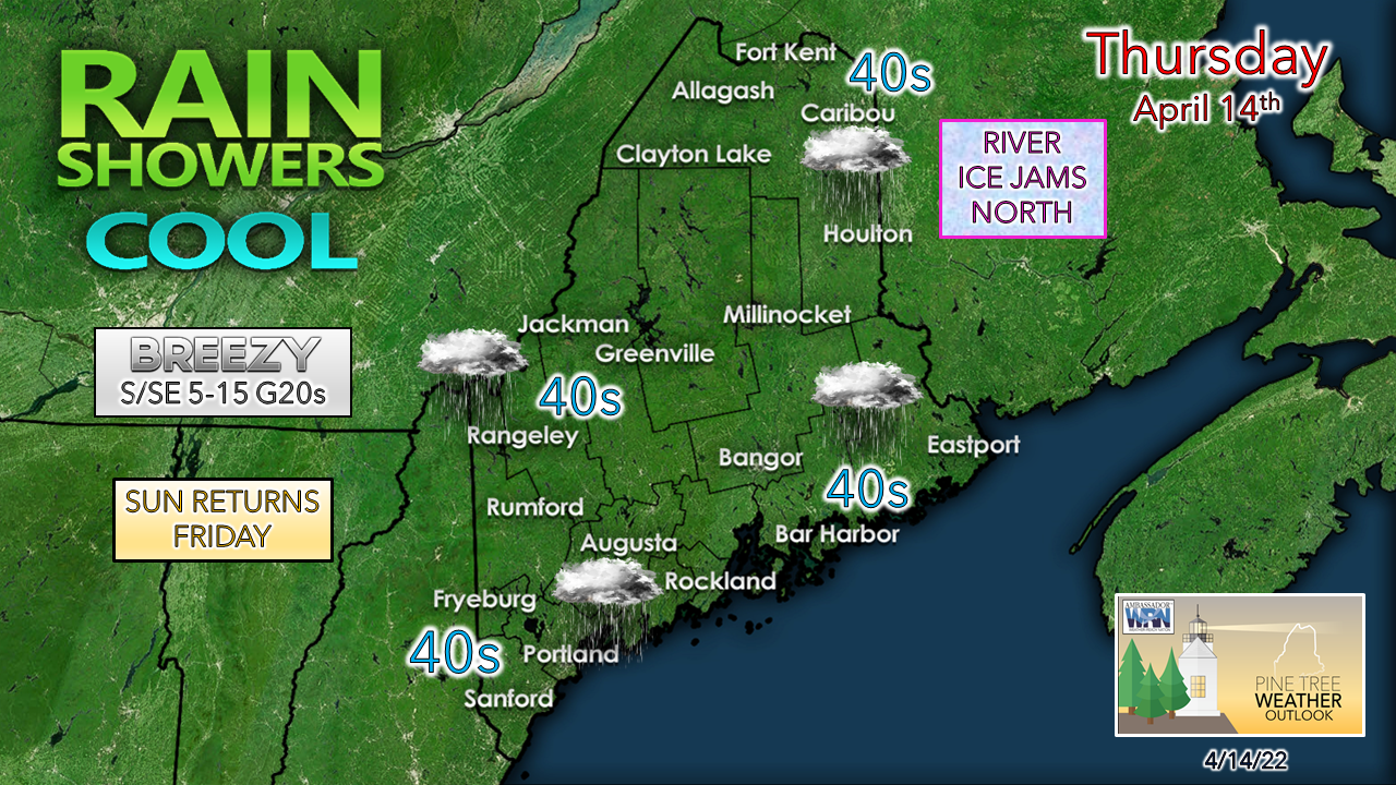 Showery, seasonably cool, raw, and blah is the best way to describe this day. Some areas may see some fog also. The backdoor cold front is near the Berkshires in Massachusetts as of early Thursday morning. While it won't be a washout, it will be damp in spots at times. A cold front passes through Thursday night, and everyone sees the sun for Friday, so there is hope. The latest on ice jams and flooding situation in northern areas from NWS Caribou: .HYDROLOGY... THE THREAT OF ICE JAMS CONTINUES ON THE SAINT JOHN AND ALLAGASH RIVERS DUE TO JAMMING OVER LOCATIONS WHERE ICE IS THICKER OR IT ENCOUNTERS ISLANDS AND/OR SUBSTANTIAL BENDS IN THE RIVER. THERE REMAINS AN APPROX 9.5 MILE JAM BETWEEN DICKEY AND ST. FRANCIS. THERE IS AN ADDITIONAL JAM ON THE ALLAGASH IN TOWN WHERE ICE CANNOT DISCHARGE INTO THE ST. JOHN. THERE IS ANOTHER SMALL JAM THAT IS CAUSING MINOR FLOODING BETWEEN LILLE AND GRAND ISLE MAINLY IMPACTING FARM FIELDS AT THIS TIME. THE LATEST SNOW SURVEY DATA FROM MONDAY AND TUESDAY INDICATES SNOW WATER EQUIVALENT OF 5 TO 9 INCHES AND SNOW DEPTH OF 18 TO 29 INCHES FROM WINTERVILLE NORTH THROUGH ALLAGASH, INDICATING THAT THERE IS STILL A SIGNIFICANT AMOUNT OF SNOW LEFT TO MELT ACROSS THE SAINT JOHN AND ALLAGASH RIVER BASINS. FURTHER SOUTH ALONG ROUTE 11, SNOW WATER EQUIVALENTS WERE LESS THAN 5 INCHES WITH SNOW DEPTHS LESS THAN 15 INCHES. HIGH TEMPERATURES WILL REACH UPPER 40S TO LOW 50S FOR THE NEXT FEW DAYS. CONTINUED RIVER LEVEL RISES ARE LIKELY AND ICE JAMS REMAIN POSSIBLE ACROSS THE ALLAGASH AND SAINT JOHN RIVERS INTO THIS WEEKEND. PRECIPITATION WILL MAINLY FALL IN THE FORM OF RAIN SHOWERS THROUGH THE WEEKEND AND BE GENERALLY LESS THAN 0.5 INCH TOTAL OVER THE ST. JOHN VALLEY. ANY ADDITIONAL RAINFALL WILL BE FALLING INTO "RIPE" SNOWPACK SO THE POTENTIAL FOR ACCELERATED SNOWMELT IS POSSIBLE. Folks in the north country should stay in contact with NWS Caribou for the latest bulletins and information. The weekend is another damp one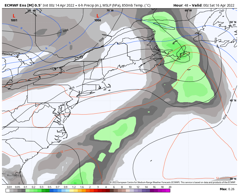 Friday 8 PM to Sunday 8 PM - After a break in the damp pattern Friday, a developing area of low pressure over the Great Lakes slides eastward. Saturday appears to be the damper of the two days with a better chance for showers in the afternoon. Sunday may see showers in the north and mountains, with just a slight risk of a shower or sprinkle for the coastal plain. Monday appears to be the next dry day statewide. 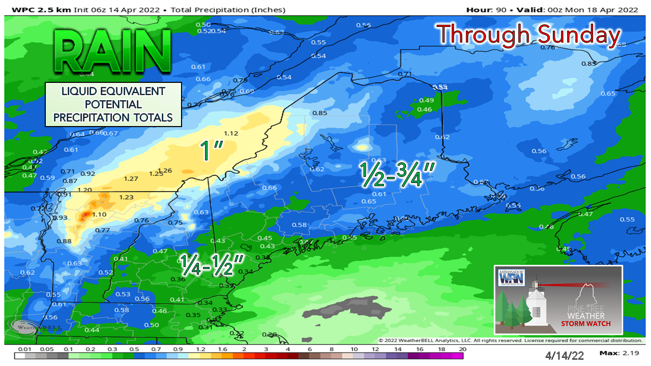 For those in the drought areas in the Rangeley / Eustis region, this is a good signal for the deficit to get a bit of relief. What you folks need at this point is a storm track where low pressure cuts through the middle part of the state from southwest to northeast, and that is the general idea for the storm over the weekend. It may be liquid, it may be a sloppy couple inches of snow, but it is something. And what about the chance for snow?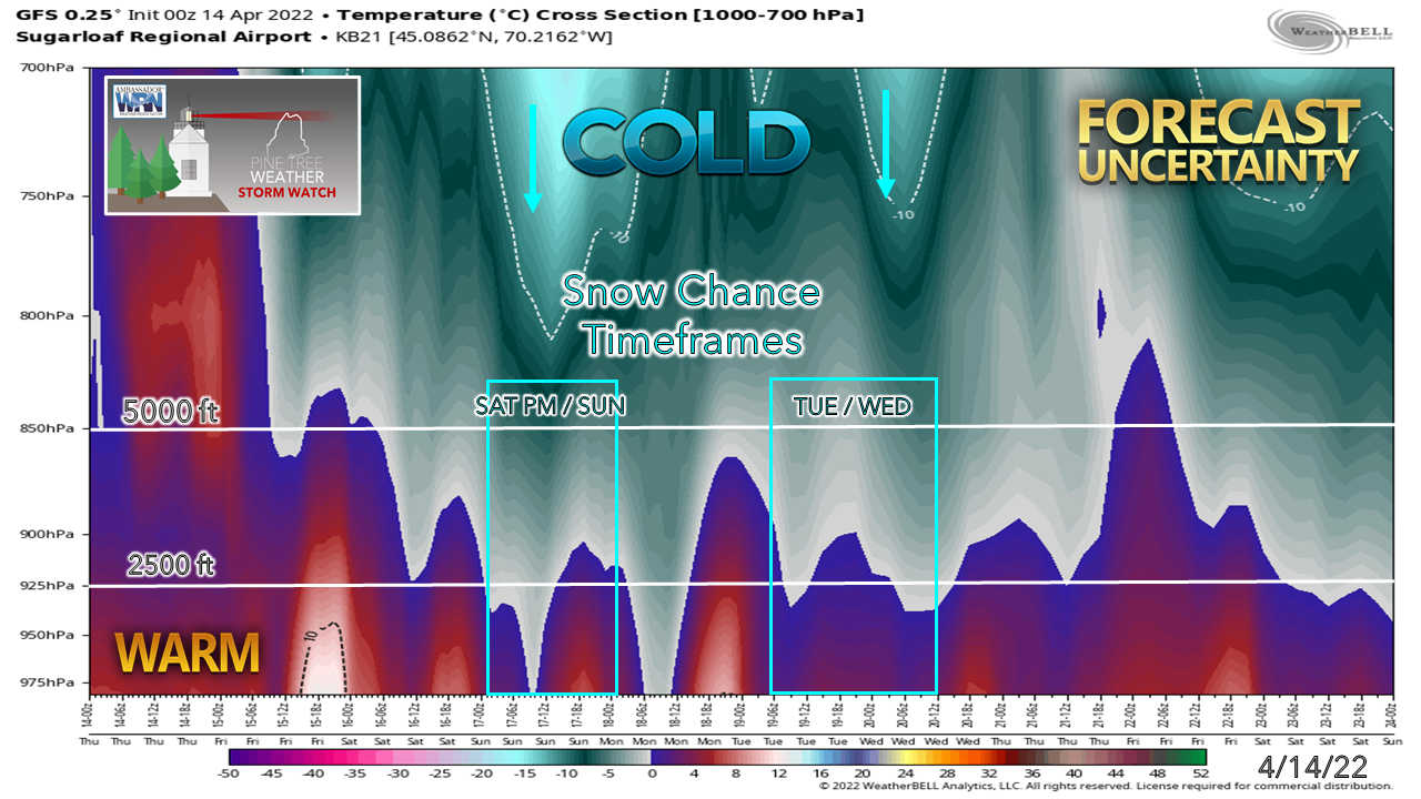 As the spring season progresses, forecasting snow gets more difficult. The atmosphere is warmer. The sun angle is higher. It depends on the forcing of energy aloft and how much cold it can tap into. The 850hPa (5000 ft) level is an indicator of possibility, but the 925hPa (2500 ft) level is where the idea of accumulating flakes is improved. Using the GFS as the idea here since it has a tendency of a cold bias at times, shows a fair chance for some snow in the mountains and north over the weekend and Tuesday / Wednesday of next week. 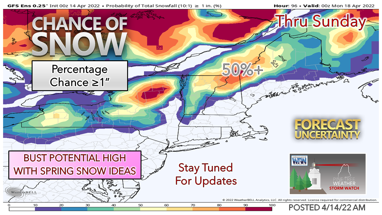 Looking at GFS ensemble idea for snowfall shows a solid chance for some wet slop in the drought region. Since the GFS isn't the only model of record to work from, I will add that northern areas could see upwards of a handful of inches of slop out this system as well Saturday into Sunday. As far as Tuesday / Wednesday goes, time will tell. Bust potential in either under or over performance is high this time of year. Whatever falls as frozen will melt quickly. Temperature outlook through TuesdayFriday is expected to be the warmer of the 5-day period, thanks to the sun, but a northwest breeze may make it feel a bit cooler over the interior. Monday appears decent, albeit a bit on the cool side for this time of year. 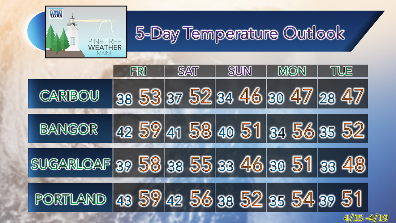 Be prepared to receive alerts and stay updated!
 For more information in between posts, please follow Pine Tree Weather on Facebook and Twitter. Thank you for supporting this community-based weather information source which operates by reader supported financial contributions. Thank you as always for your support! - Mike NOTE: The forecast information depicted on this platform is for general information purposes only for the public and is not designed or intended for commercial use. For those seeking pinpoint weather information for business operations, you should use a private sector source. For information about where to find commercial forecasters to assist your business, please message me and I will be happy to help you.
|

Mike Haggett
|