|
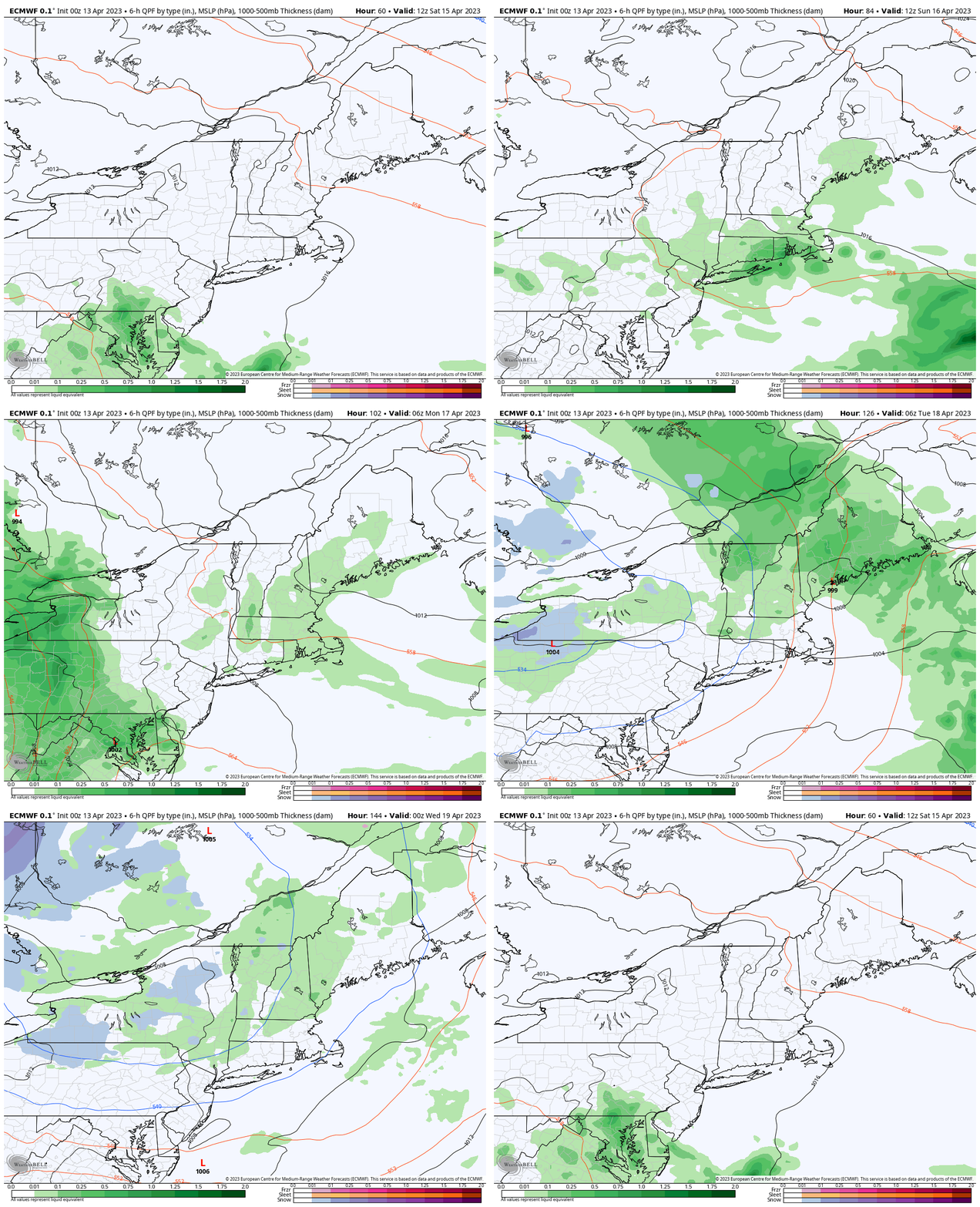
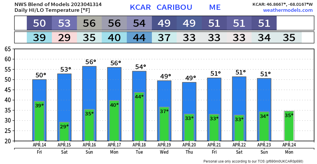
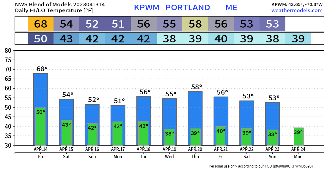
A quick personal update before I begin. I was making good progress for a while with my arthritis and then had a setback late last week. It's been demoralizing, but I understand that it is part of the process. The positives here are that I am continuing to maintain my new normal since mid-February being gluten-free, sugar free, and dairy free, as well as walking on average of 4-7 miles a day. I have dropped 15 pounds and feel great, other than this lingering pain in my thumb knuckles. I've been a fighter most of my life. With over 31 years of recovery from alcohol and drug addiction, I understand the battle that I am facing here. I will find a way with this as I have gone through everything else. Thanks for hanging in there with me and your patience. Weather to act more like April heading into next weekLooking at the steering level pattern through late next week, the upper-level ridge block that brought warm temperatures and dry conditions erodes heading into the weekend. A cut-off upper low drops down from Canada heading into early next week and brings more in the way of clouds and showers starting Sunday and continuing off and on through Thursday. A weak ridge is expected to build heading into the following weekend, which may bring some showers then as well. Outlook through WednesdayThe region stays dry until the weekend. A ridge is expected to build into the area Saturday and may bring a sprinkle or light shower over southwestern areas in the afternoon. The ridge begins to fall apart as an upper-level trough moves into the area from the northwest. Some light showers / sprinkles are more likely over the area on Sunday. The aforementioned upper-low dips into the Great Lakes region heading into Monday, which will bring the best chance for rain showers Monday afternoon into early Tuesday. With the upper-low cut off and no forcing to move it thanks to upstream blocking, it will sit and spin over the area through Wednesday. As the upstream traffic jam breaks free, a weak upper ridge builds in starting Wednesday night, but it appears strong enough to move the upper-low or its remnants to the east for a bit of a break on Friday. Nothing in the way of severe weather is expected. The rainfall idea over the region mainly from the boundary moving in Monday afternoon into early Tuesday indicates a general ¼-¾" of liquid from this vantage point Thursday morning. There is a chance for more if the upper-low dips further to the south, or less if it stays further to the north. With the region being generally dry this month, any rainfall would be welcomed at this point. Temperature outlook close to normalThe average high and low for Caribou is 46° and 28° for April 13th. The overall trend is for slightly above normal temperatures on the high and low end through next week. The normal high and low for Portland for April 13th is 53° and 35°. After one more warm day to come Friday, the outlook is right around normal on average through next week. My next update will come Tuesday 4/18Pine Tree Weather is funded from followers like you. I would appreciate your financial support. Click here for how you can contribute. You may not like the weather, but I hope you like what I do! Please hit the like button on Twitter and Facebook, and share! Stay updated, stay on alert, and stay safe! - Mike NOTE: The forecast information depicted on this platform is for general information purposes only for the public and is not designed or intended for commercial use. For those seeking pinpoint weather information for business operations, you should use a private sector source. For information about where to find commercial forecasters to assist your business, please message me and I will be happy to help you. |
Mike Haggett
|


