
What to expect through early next week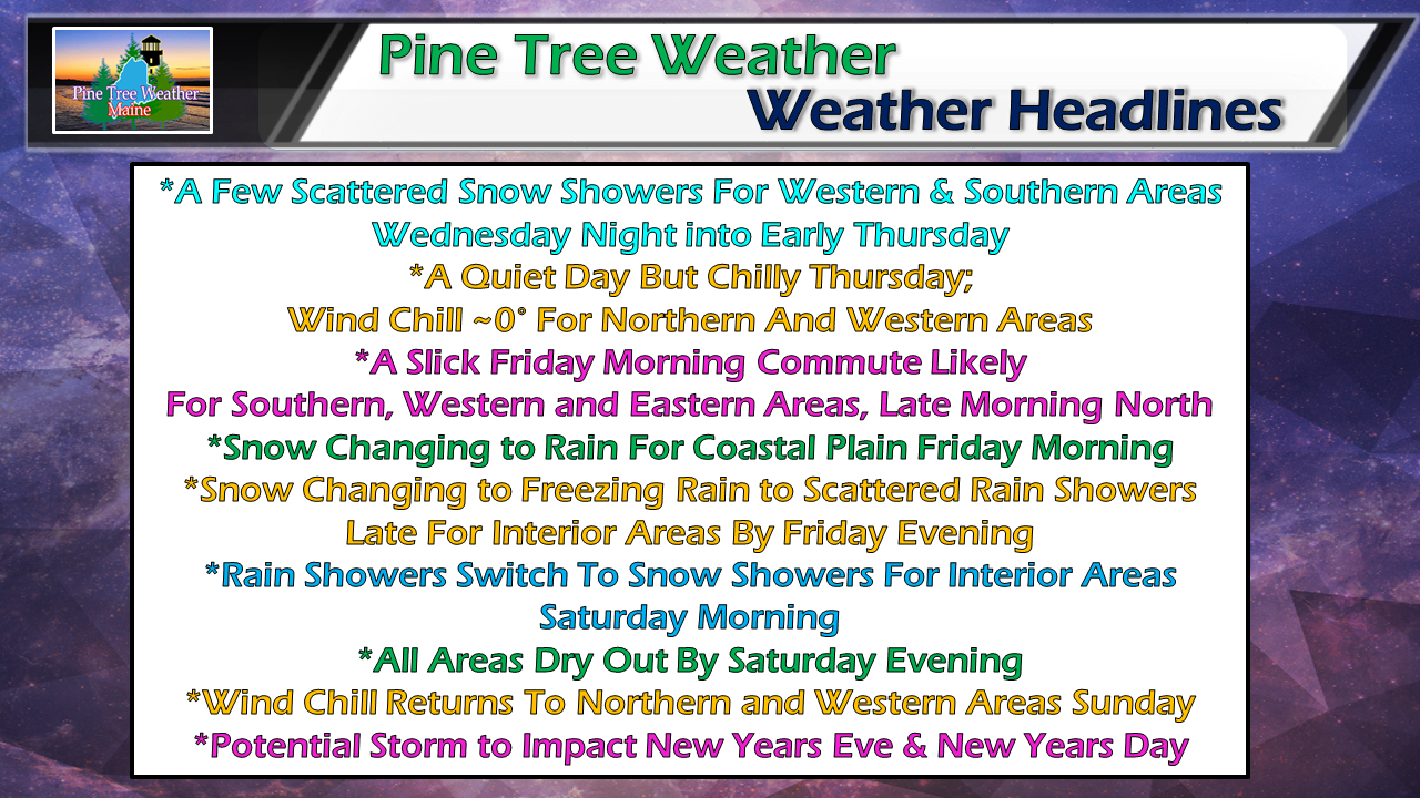 A few light snow showers are possible overnight as a weak frontal boundary moves quickly through Vermont, New Hampshire and western and southern Maine. Some areas may get a inch out of it, other areas a few flakes, or nothing. If traveling overnight, use caution in case of any snow covered roads. With the recent rain, roads have lost their salt and/or calcium chloride treatments, which could make roads slick where snow accumulates. Friday to be messy, especially over interior areas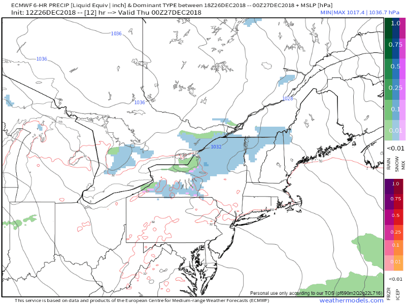 After high pressure brings a chilly day for the state on Thursday, low pressure advances from the southwest. Precipitation breaks out in the wee hours of Friday, which is likely to cause greasy roads for much of the state in time for the morning commute. Cold air damming appears to help interior areas stay in the snow / freezing rain for much of the event, turning to scattered rain showers by Friday night. The coastal plain may start off with brief period of snow / mix before changing to rain Friday morning around daylight for the southwest & MidCoast, mid to late morning for DownEast areas. A cold front approaches Saturday morning which appears to switch the interior areas back to snow showers, and gusty northwest wind brings cold air back in through the remainder of the weekend. 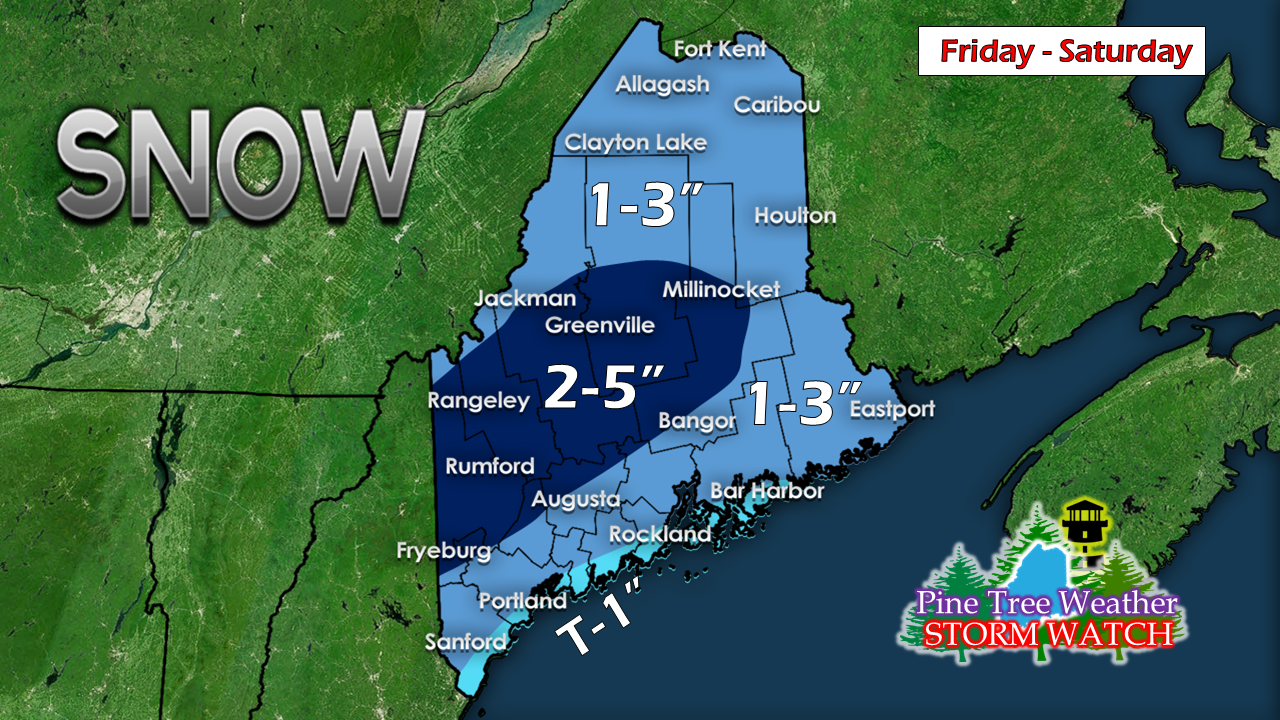 Interior areas are likely to see the most snow from the event, along with a trace to a tenth of an inch of ice. Higher elevations should see mostly snow from the storm, with a light icing possible Friday afternoon into the evening. The new snow over the mountains and central regions should hold up well as any liquid precipitation appears to be light in the overnight hours, and then will change back to snow showers as the cold front sweeps through Saturday morning. Outlook through New Year's Eve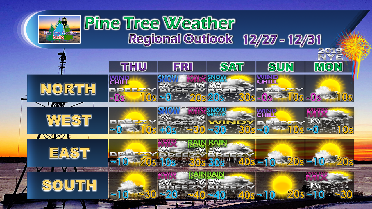 Folks headed for the ski hills this weekend should bundle up as temperatures drop Saturday afternoon into Sunday morning. Wind chill values will be flirting with 0° Sunday. New Years Eve appears to start off well, with clouds on the increase and precipitation breaking out over southern and western areas in the evening.
Stay tuned for updates! For the latest official forecasts, bulletins and advisories, please check in with the National Weather Service in Gray for western and southern areas, or Caribou for northern and eastern parts of Maine. Pine Tree Weather is now 90% funded to get through October of 2019. My anticipated current deficit now stands at $350 remaining to be raised to reach my goal. I am sincerely blessed and humbled by your financial contributions, cards, and messages of encouragement. It's been an amazing journey over the past 7 years, and to see my efforts appreciated by those that follow is a wonderful reward for my work. My request is for $1 per month / $12.00 per year through my Patreon page or by sending me a message on Facebook or Twitter to mail a check. The popular contribution has been $5 per month / $60 per year on Patreon, and the check donations average out to same amount as well. For those who have already donated, I sincerely thank you. For those who have yet to, I would sincerely appreciate your support in order to be fully funded by the end of the year. For more information from me, please follow the Pine Tree Weather Facebook page and my Twitter feed. Always stay weather aware, and thank you for your support! - Mike |

Mike Haggett
|


