
|
The "drunk uncle" upper-low that has been an annoying guest since last Saturday finally packs his bags and heads out of the area. This pattern is certainly acting like El Niño, and NOAA sent out a press release declaring its arrival earlier in the week. While there is some drought currently occurring in Maine, most of the state is near normal or above average precipitation wise for the year. With the recent La Niña years causing more widespread drought, this is good news. Looking at the pattern through the rest of June, rain chances continue, and the heat and humidity will stay away for now. Showers with a better potential for storms Saturday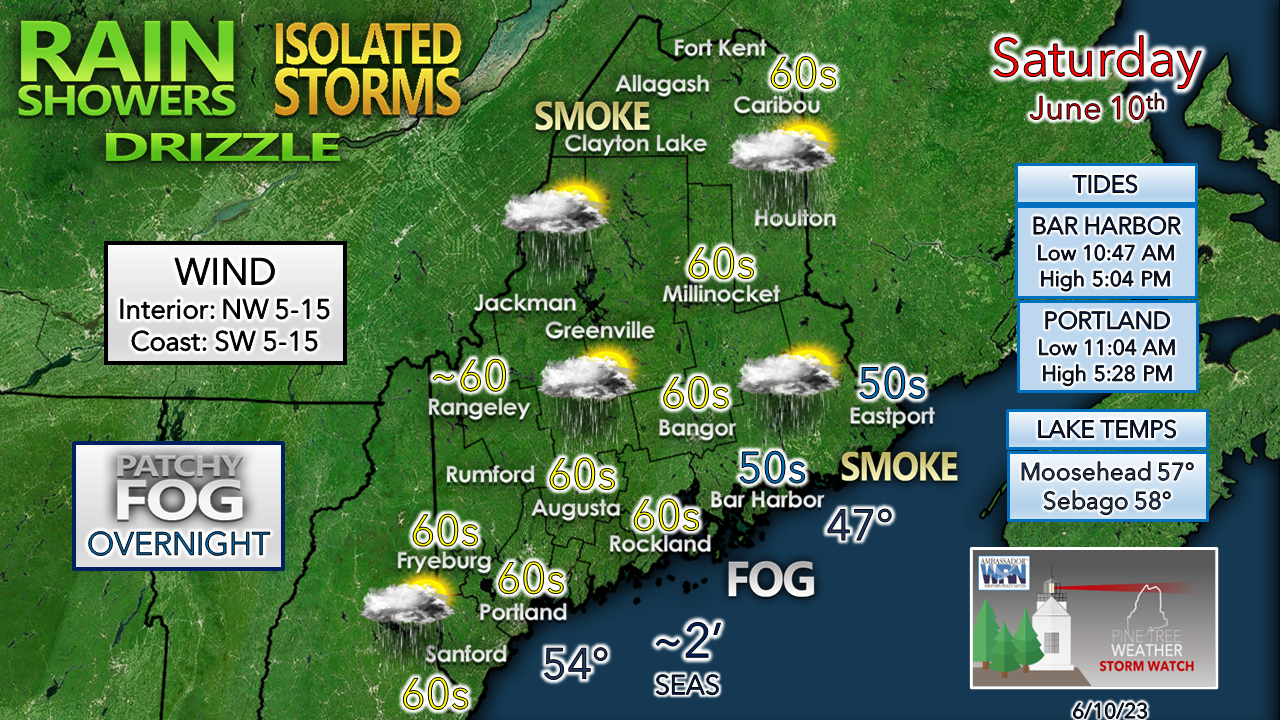 Some fog around to start the day and may end with fog in areas overnight into Sunday. Smoke from the wildfires in Quebec may cause some hazy conditions as that wraps around the departing upper-low. Air quality impacts from it appear minimal per the Maine Department of Environmental Protection. You may catch a whiff of it, or it may be the guy down the street burning brush to make you think it may be from that. Temperatures tick up a couple of degrees more than Friday. Coastal areas get the sea breeze which will keep temperatures down a bit there.  Saturday 9 AM to Sunday Midnight - Another day of hit or miss showers and storms are on tap. With the sea breeze anticipated, this may set up a boundary over the coastal interior that may juice the popcorn showers and storms along it. The severe potential is very low. There could be a risk of a stiff puff of wind and small hail and a quick hit of rain. I am not expecting any widespread flash flooding concerns, but it may be locally heavy in spots. As the sun sets, showers and storms end, and the drunk uncle heads for the north Atlantic. Outlook through midweekSunday appears to be the best day statewide of the previous eight days. I do expect a mix of sun and clouds, a risk of a pop-up shower in the mountains, and for coastal areas to be a bit on the cool side with the onshore breeze in the afternoon. There could be a smoky haze around to dim the sky as well. It will be a great day to go outside with warmer temperatures and comfortable humidity. Clouds will be on the increase Monday over southwestern areas and there is a risk of a pop-up shower in that area. Northern and eastern areas see the most sun, and warmer temperatures. The next upper-low works into the area Tuesday.  Monday 8 PM to Thursday 8 PM - The upper-low spins up a surface low over the Great Lakes and drags moisture up from the south. The surface low spins itself out fairly quickly as the frontal boundary passes through Maine on Tuesday. As the upper-low meanders through the area, it will spin waves through keeping the risk of showers and potential thunder in the forecast through Thursday. Notice that ocean storm that flares up along the boundary of the upper-low off the Del-Mar-Va on Thursday. If that happens, there may be some subtropical characteristics with it. While not a threat to Maine, it is a reminder that hurricane season is here. This upper low isn't as cold, nor is it going to hang around for long, and should be gone by Friday. 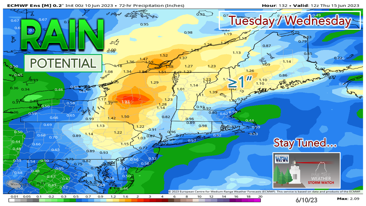 Ideas on rainfall look healthy with over an inch or more possible. This will also help douse at least some of the wildfire activity in Quebec and reduce the smoke from that. 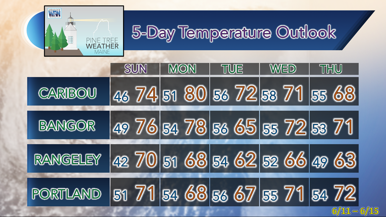 Pine Tree Weather is funded from followers like you. I would appreciate your financial support. Click here for how you can contribute. You may not like the weather, but I hope you like what I do, and support my efforts. Thank you! Stay updated, stay on alert, and stay safe! - Mike NOTE: The forecast information depicted on this platform is for general information purposes only for the public and is not designed or intended for commercial use. For those seeking pinpoint weather information for business operations, you should use a private sector source. For information about where to find commercial forecasters to assist your business, please message me and I will be happy to help you. |

Mike Haggett
|


