Pine Tree Weather
  • DISCUSSIONS
  • DONATE
  • WEATHER WALL
  • MAPS
  • RAIN OUTLOOK
  • SEVERE
  • MARINE
  • CPC OUTLOOK
  • Kennebunk
  • MY BIO
  • PTW IN MEDIA
  • OBSERVING WEATHER
  • INTERNSHIPS
  • INTERN ALUMNI
  • DISCUSSIONS
  • DONATE
  • WEATHER WALL
  • MAPS
  • RAIN OUTLOOK
  • SEVERE
  • MARINE
  • CPC OUTLOOK
  • Kennebunk
  • MY BIO
  • PTW IN MEDIA
  • OBSERVING WEATHER
  • INTERNSHIPS
  • INTERN ALUMNI

An active pattern ahead with as many as four storms possible

2/26/2023

Comments

 
A quick status update before I get into the outlook to say that my hands are doing better. I backed off social media since Thursday morning and did the bare minimum keyboard work as I could the rest of the week and stayed off everything on Saturday to give the digits a rest. 

So about that backloaded winter I have talked about since Christmas... 

Clipper to bring snow Sunday

Picture
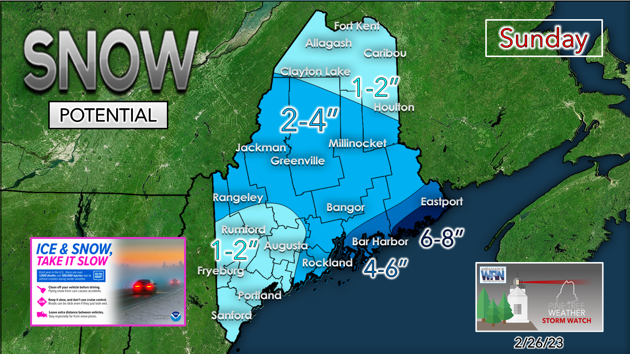
A clipper system passes through the region on Sunday and has enough juice to bring some high fluff potential snow across the region. The National Weather Service Caribou office has issued a Winter Weather Advisory for Coastal Hancock and Coastal Washington Counties from noon Sunday to 4 AM Monday. 
Picture
Sunday 10 AM to Monday 7 AM - Snow breaks out across the region by midday and streams from northwest to southeast during the afternoon and into the night. . This big fluff event, with 20:1 snow to water ratios possible here, which would essentially double the output you see in the hourly forecast idea shown above. The icy nature of the snow is likely to create some slick spots, especially for the less travelled roads. for most of the area.

There is the potential for enhancement of snowfall for MidCoast and DownEast coastal areas given the warm ocean temperatures and low pressure forming over the Gulf of Maine. Areas east of Penobscot Bay have the better chance for higher totals as the forecast snowfall map indicates. That said, Folks in the Knox County and Coastal Waldo County areas should take note of the potential for additional accumulations.

The region to be caught in split flow pickle for Tuesday

Picture
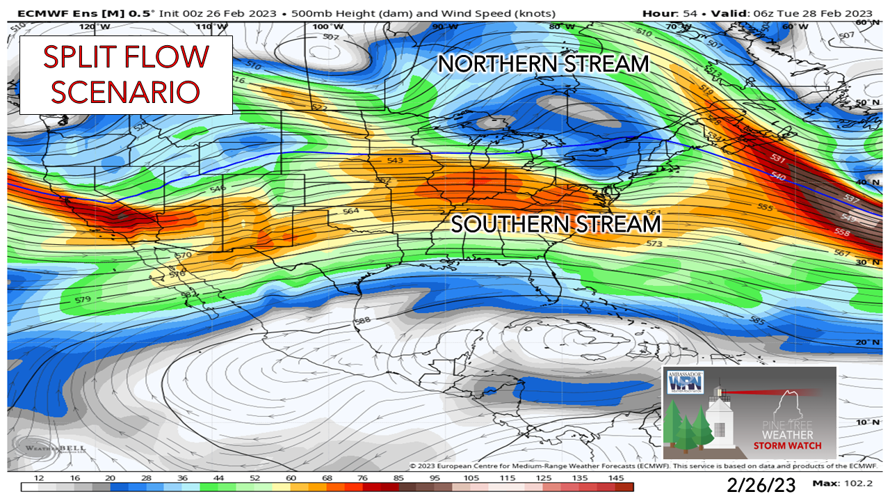
Red flags all over the place on this storm as it could go either way on higher or lower snowfall accumulations given the set up.  There will be plenty of cold air around, so there is little chance of any junk (sleet, freezing rain) with the possible exception of the offshore islands. The southern stream holds the card on how this one plays out. 
Picture
Monday 7 PM to Wednesday 7 PM - Three features here to watch in this European ensemble mean loop. The first is the weakening low travelling from Manitoba into Hudson Bay. The second is low pressure that is siphoning off energy from that near the Great Lakes. The third is the developing ocean storm off the MidAtlantic coast that will steal the energy from the Great Lakes system.  A cold front forms along all three areas of low pressure and moves east toward Maine Monday night and Tuesday, and slowly passes through Tuesday night into Wednesday.
Picture
Tuesday 1 AM to Wednesday 1 PM - The sum of the ingredients creates an elongated and slow-moving inverted trough set up which is what will bring snow to the region. This is where the forecast gets a bit dicey. If the southern stream and developing coastal low comes in a bit further north towards the benchmark 40° N / 70° W point, that would bring more snow to southwestern areas. On the flip side, if it tracks further south, it would bring less snow. 

Expect the morning commute to be slick over the south and west to start off. Most areas with the possible exception of northeast Aroostook are likely to have impacts for the evening commute. Eastern areas including Bangor may see a slick start to Wednesday but should see improvement as the front exits to the east by mid-morning. 
Picture
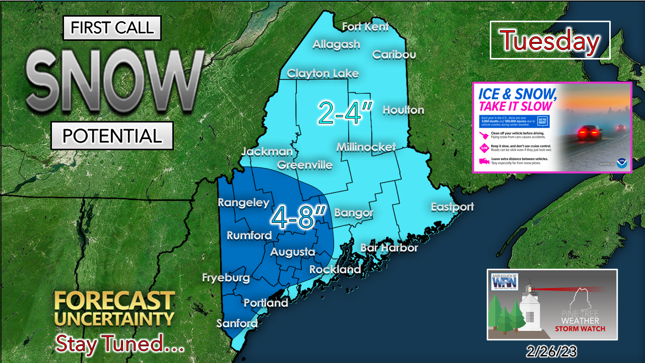
The jury is out right now on whether mixing along the coast may occur. There will be a northeast wind associated with this that may draw in warmer air from the ocean. I've included that potential in the forecast map for now. I do expect a breezy day across the region in the 20-30+ mph range (higher gusts for the coast, potentially mountains as well) which will blow the snow around and may cause some brief whiteout conditions and some minor drifting. 

Another storm Thursday;
a coastal brush possible to wrap up the week

Picture
Thursday 1 AM to Friday 10 AM - This was full-on inside runner junk storm in earlier ideas, but that idea has trended cooler with a track to the southeast into the Gulf of Maine. This may be the best storm of the week for accumulation potential pending on the timing of the pieces falling into place. 
Picture
Friday 1 AM to Saturday 1 AM - On the heels of Thursday's potential comes potential for a coastal brush at least for Friday. With the track of the ocean system south of the benchmark point, this would likely be an all-snow event if the trend continues. 

Buckle up, folks. Get what you need for supplies and prepare for a busy week. Check the washer fluid in your vehicle, change your wipers if you need to, keep the gas tank full, and prepare for closings, cancellations, and slow travel. 

Stay updated! 

Temperature outlook through Friday

Picture

Thank you as always for your support!

You may not like the weather, but I hope you like what I do! Please hit the like button
​on Twitter and Facebook, and share!

Financial donations to fund what I do are always appreciated!

Stay updated, stay on alert, and stay safe!

- Mike

​NOTE: The forecast information depicted on this platform is for general information purposes only for the public and is not designed or intended for commercial use. For those seeking pinpoint weather information for business operations, you should use a private sector source. For information about where to find commercial forecasters to assist your business, please message me and I will be happy to help you

Comments
    Picture

    Mike Haggett
    Kennebunk, ME

    Weather-Ready Nation
    Ambassador

    Certified Weather
    Forecaster
    Penn State '21

    American Meteorological Society

    National Weather Association
    ​
    ​SKYWARN-CWOP

    Matthew 19:26


    DONATE

    Picture
    Picture
    Picture
    Picture
    Picture

    Picture

    Picture

    Picture

    Picture

    Picture

    Picture

    Picture

    Picture

    Picture

    Picture

    Picture

    Picture


    Archives

    April 2025
    March 2025
    February 2025
    January 2025
    December 2024
    November 2024
    October 2024
    September 2024
    August 2024
    July 2024
    June 2024
    May 2024
    April 2024
    March 2024
    February 2024
    January 2024
    December 2023
    November 2023
    October 2023
    September 2023
    August 2023
    July 2023
    June 2023
    May 2023
    April 2023
    March 2023
    February 2023
    January 2023
    December 2022
    November 2022
    October 2022
    September 2022
    August 2022
    July 2022
    June 2022
    May 2022
    April 2022
    March 2022
    February 2022
    January 2022
    December 2021
    November 2021
    October 2021
    September 2021
    August 2021
    July 2021
    June 2021
    May 2021
    April 2021
    March 2021
    February 2021
    January 2021
    December 2020
    November 2020
    October 2020
    September 2020
    August 2020
    July 2020
    June 2020
    May 2020
    April 2020
    March 2020
    February 2020
    January 2020
    December 2019
    November 2019
    October 2019
    September 2019
    August 2019
    July 2019
    June 2019
    May 2019
    April 2019
    March 2019
    February 2019
    January 2019
    December 2018
    November 2018
    October 2018
    September 2018
    August 2018
    July 2018
    June 2018
    May 2018
    April 2018
    March 2018
    February 2018
    January 2018
    December 2017
    November 2017
    October 2017

Proudly powered by Weebly