|
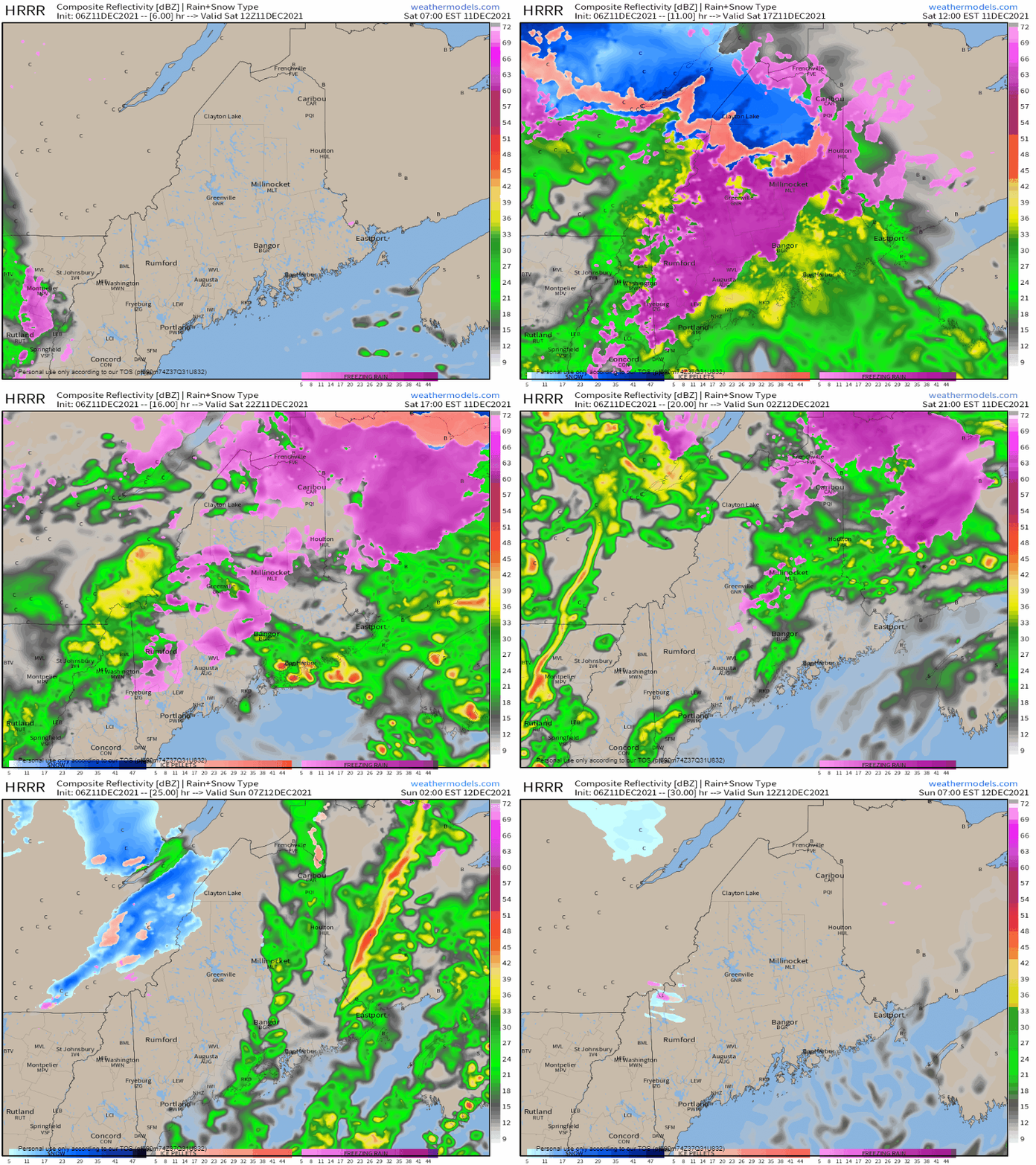
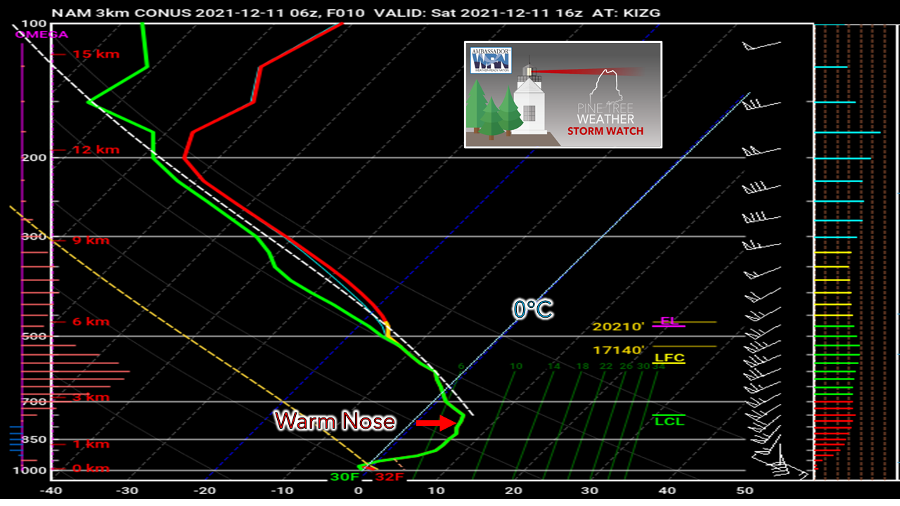
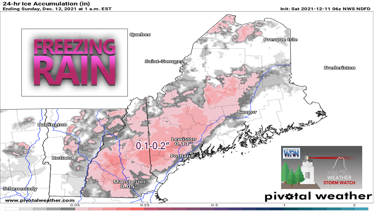
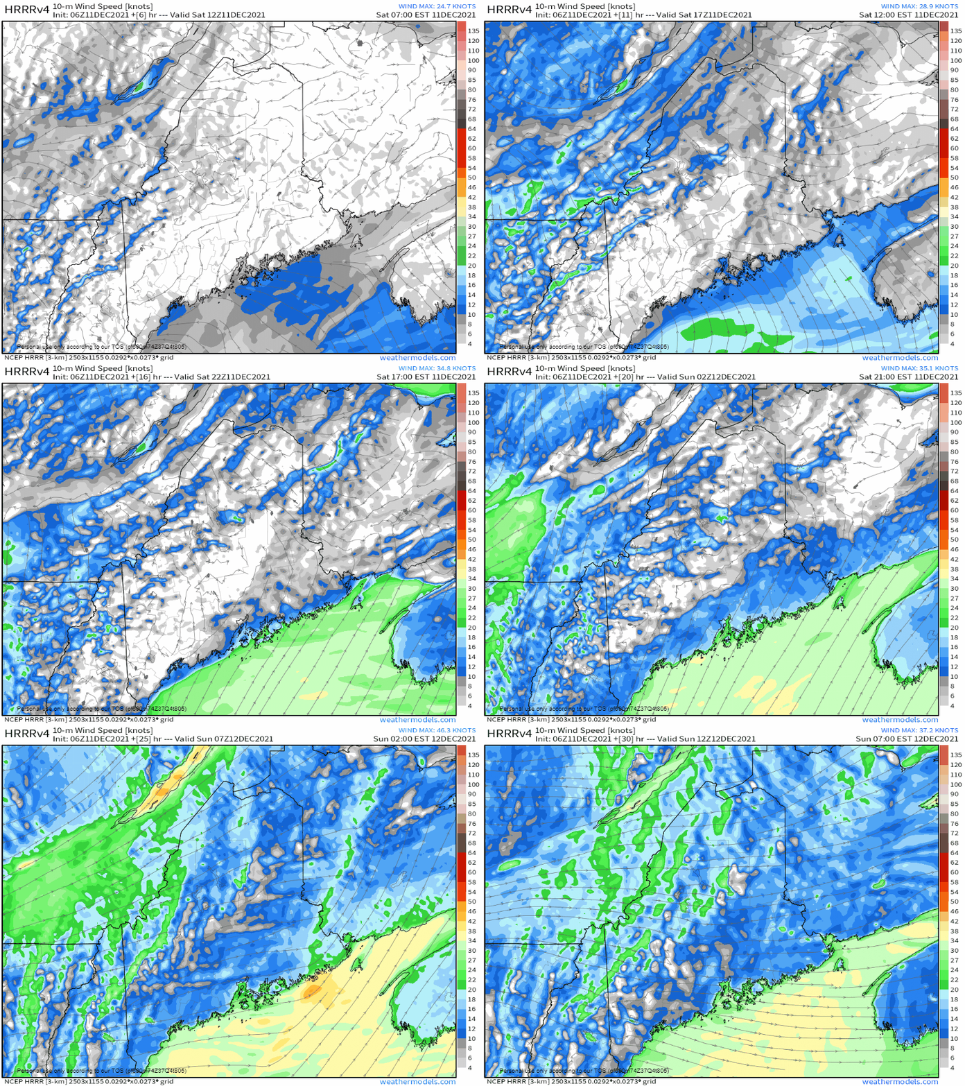
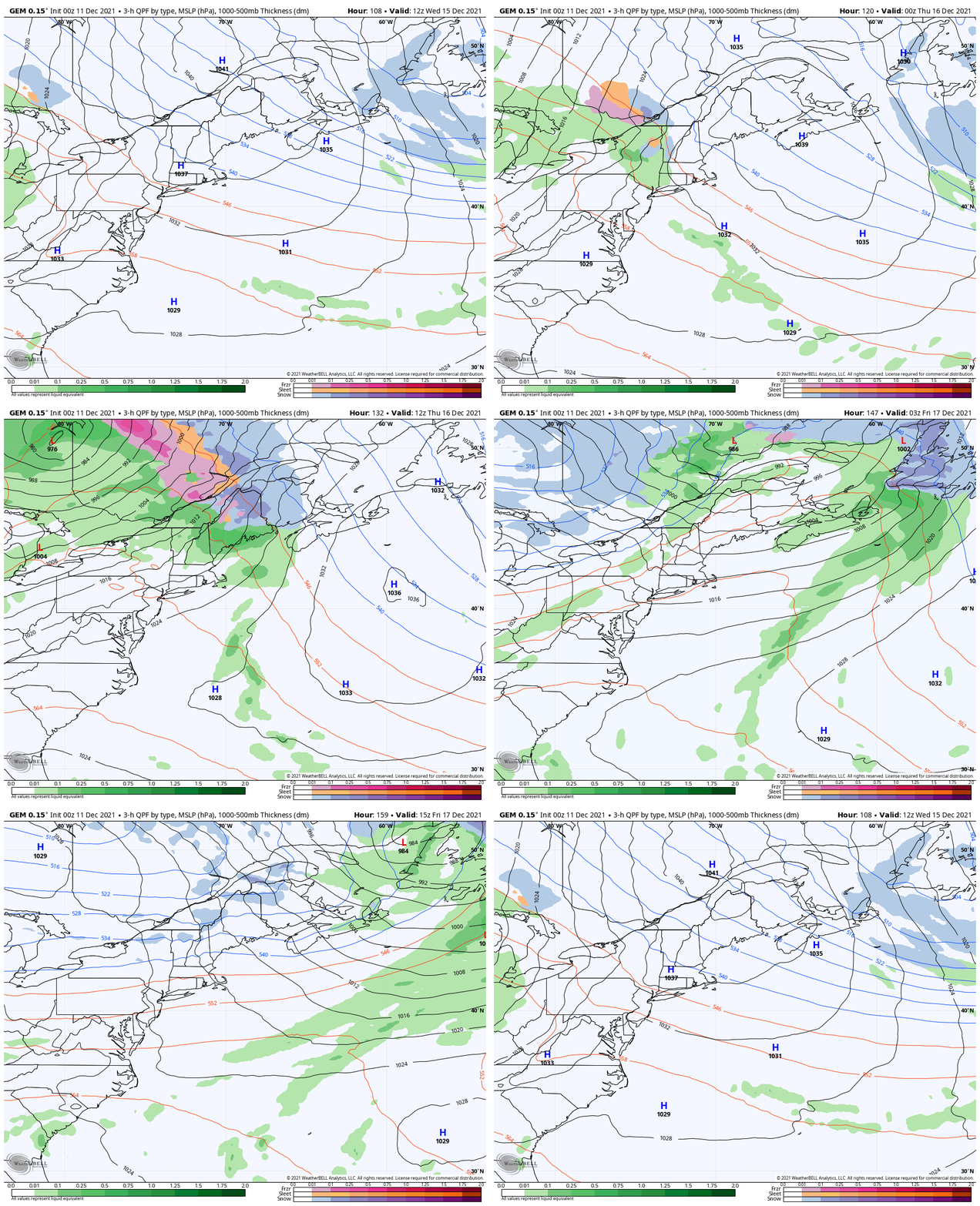
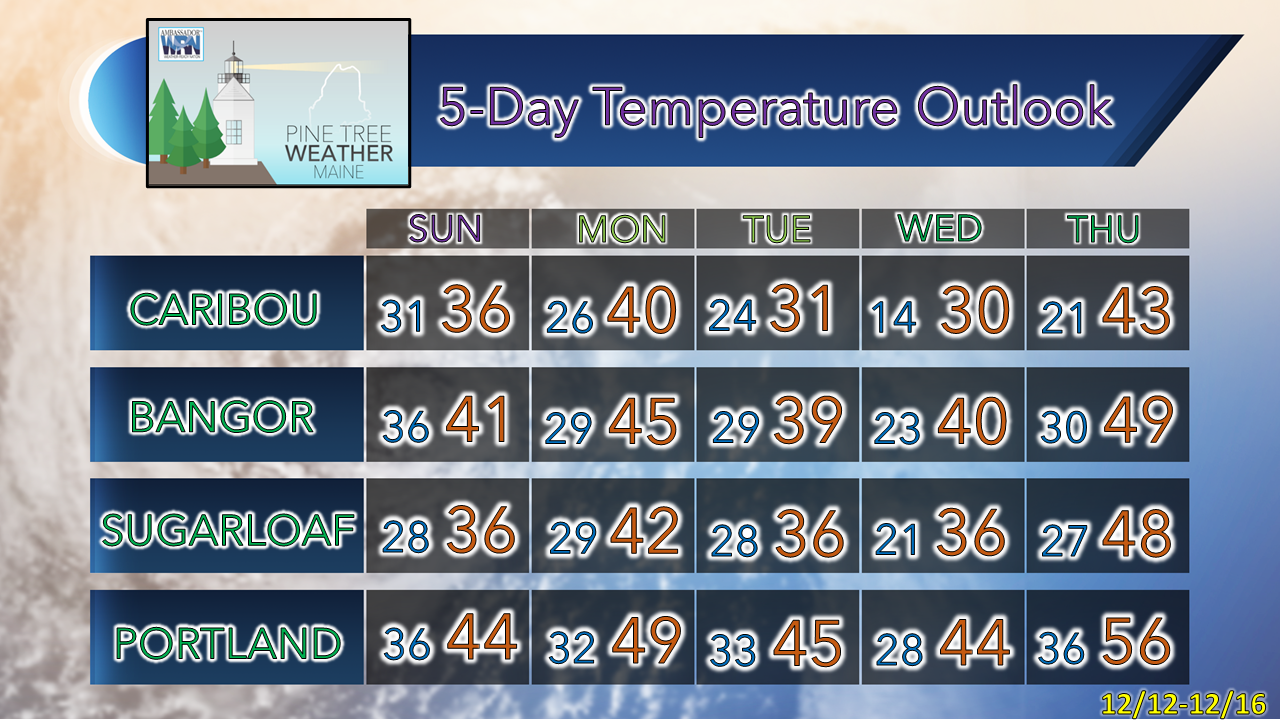
Before I get into the forecast, a couple things here, I am back to normal after a rough couple of days dealing with medical treatment. I appreciate the comments and messages of encouragement and support. Also want to thank those for their donations in the past few days here. I am not exactly sure where I am at with a dollar figure to cover the bills for 2022 at the moment, but I know that I am getting close. Thanks for having my back here, and I would appreciate your support if you have not contributed already. There is a banner below, along with the DONATE tab on the menu where you can get information as to how you can contribute. Thank you for passing my efforts along to others as well. Today is an mPing day! Please use the app to anonymously report your current conditions. It is extremely helpful in situations like this to know what you are seeing to improve forecasting. We've dealt with worse iceThis storm is more of a nuisance than anything. As I have mentioned on Facebook the past couple of days, this is similar the storm earlier in the week. Cold air damming is definitely in place and is going to be an issue. There is a bit more wind associated with this event as the inside runner intensifies on its way out the door and strong high pressure associated with a highly anomalous ridge pushes eastward into the area behind it. Saturday 7 AM to Sunday 7 AM - While this idea may not be perfect, it is a particularly good indicator of the precipitation type that is on the way. Arrival of precipitation has moved back an hour from the idea I presented on Facebook Friday, which is a benefit. Whatever heat can be generated by solar insolation (daylight) in these events where a matter of a handful of degrees is critical to the outcome. Phase one of precipitation enters southern and western areas by mid-morning and overspreads the state by midday. Where interior areas see a lull is where to watch out for areas of patchy freezing drizzle and perhaps freezing fog. Areas along the shorelines may experience warm pockets of drizzle and fog as well. Phase two in the form of a cold front passes through tonight which brings heavy rain and gusty wind. Cold air comes in behind the front and could bring snow showers and a squall or two on the backside for the western mountains heading into Sunday. WEATHER NERD WARNING: Here's a look at the atmosphere over interior southwestern areas to better understand what is going on here through what is known as a skew-T diagram. I will use Fryeburg as the example point, and the forecast idea is for noon Saturday: This is a classic freezing rain set up here. The 0°C (32°F) line is highlighted to show the warm nose aloft. Note how shallow the cold is at the base. In these scenarios, Mount Washington could be 10-15° F warmer than the valleys around at this time. That is precisely what this model idea is suggesting. Warm air from the southwest aloft is pushing moisture in. Dew point (green line) and actual air temperature (red line) chase each other from 18,700 feet to close to the surface. The key point to note is the slow speed southeast breeze near the surface. This is cold air damming, and what interior areas will be dealing with all day. The window of above freezing temperatures is likely to come, but it may not happen until the evening. As the cold front approaches the region after dark, the wind ahead of it brings temperatures above freezing. This will melt off whatever ices up during the course of the day. This model idea may be a touch warm. I am not confident that +32° will occur this far inland by 3 PM (15:00). It may be this evening, but I have full confidence that is coming. The front is expected to pass through the region around midnight, and then the cold pours in behind it and rapidly dropping temperatures. With the charge of rain on the way, expect areas of black ice over interior areas to start Sunday. The amount of ice accretion is just enough to create slick spots on untreated surfaces. The ice should melt everywhere with the warmup Saturday night. Please use caution as you travel by car or on foot. The number one winter weather condition health hazard is broken bones because of falls associated with ice. Stay upright and stay out of the hospital, which with COVID going on, isn't a bad thing. If you aren't secure on your feet, just stay home. Now the wind factor... Saturday 7 AM to Sunday 7 AM - For the DownEast shorelines, please note that the National Weather Service has issues a wind advisory from 7 PM Saturday to 7 PM Sunday as southwesterly winds are expected in the 20-30 mph sustained range and gust to 50 mph. Gusts from the south/southwest over land could reach 45+ mph over land as the cold front approaches Saturday night. The combination of all that means isolated power outages are possible. If you are in an area prone to losing power, be prepared to lose it. Wind gust speeds from the west in the 30-40 mph are possible Sunday morning, settling down in the afternoon heading into Sunday night. Storm pattern kicks back up late weekWednesday 7 AM - Friday 7 PM - The aforementioned anomalous ridge keeps the region quiet from precipitation through the first half of the week. A strong area of high pressure moves east on Wednesday with an inside runner moving in Wednesday night / early Thursday. Another inside runner is possible next Saturday. Temperatures are expected to be well above normal through much of the week. Please report your weather observations via mPING!Check out the mPING (Meteorological Phenomena Identification Near the Ground) project. Weird name, cool app! You can report the type of precipitation you see where you are. No need to measure! Use the free mobile app to send reports anonymously. Reports are automatically recorded into a database, which improves weather computer models. The information is even used by road maintenance operations and the aviation industry to diagnose areas of icing. mping.nssl.noaa.gov #CitizenScience Be prepared to receive alerts and stay updated!
For more information in between posts, please follow Pine Tree Weather on Facebook and Twitter.
Thank you for supporting this community-based weather information source which operates by reader supported financial contributions. - Mike |
Mike Haggett
|

