
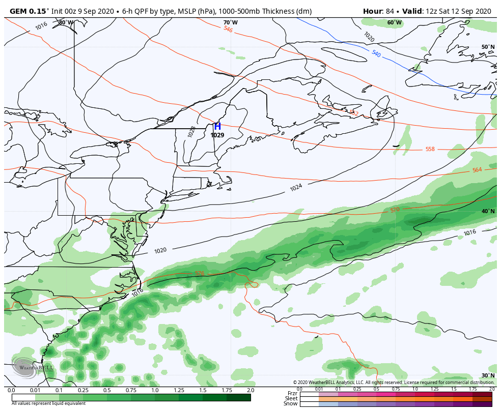
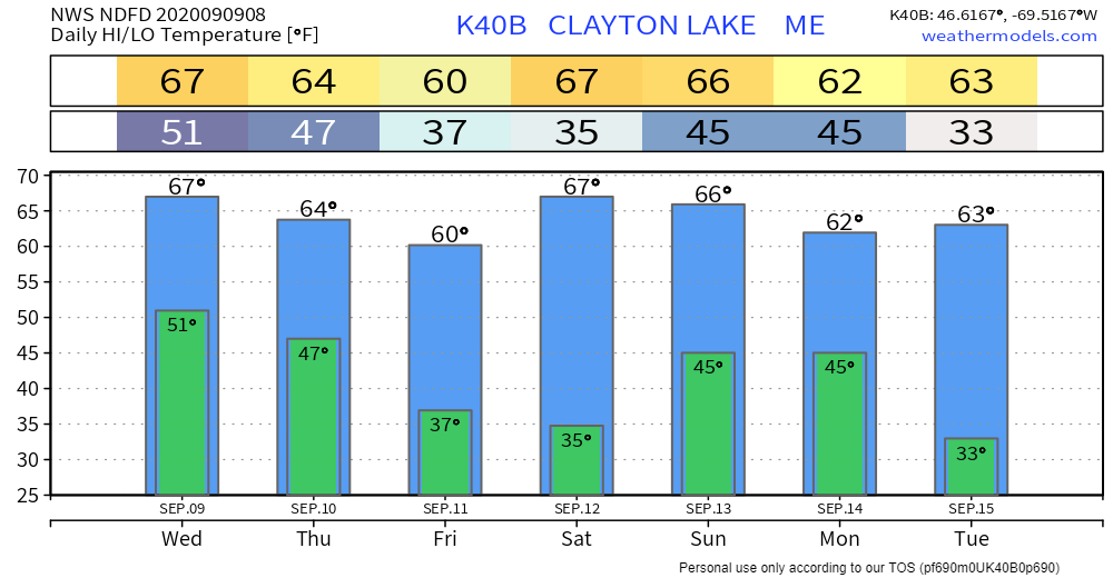
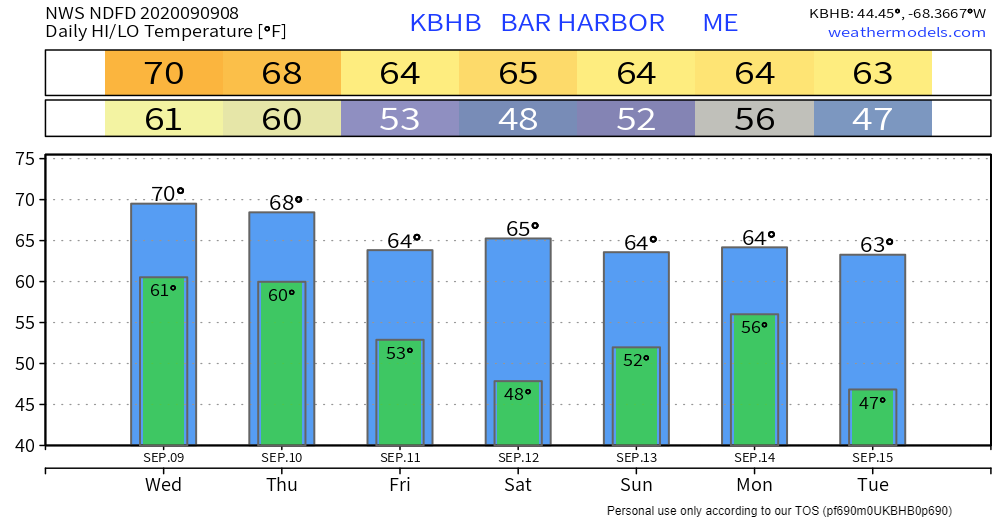
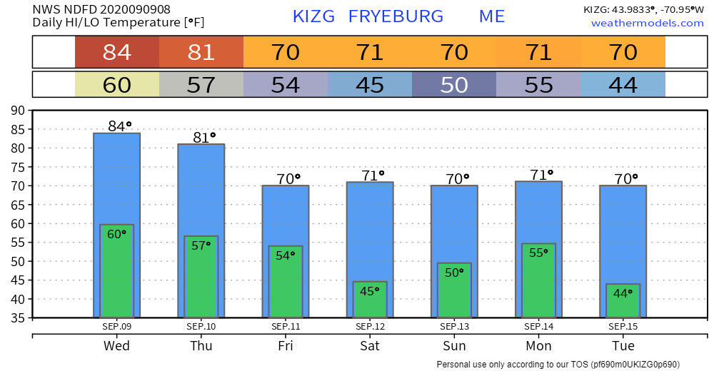
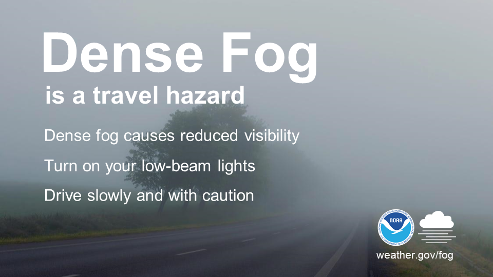
It looks like fall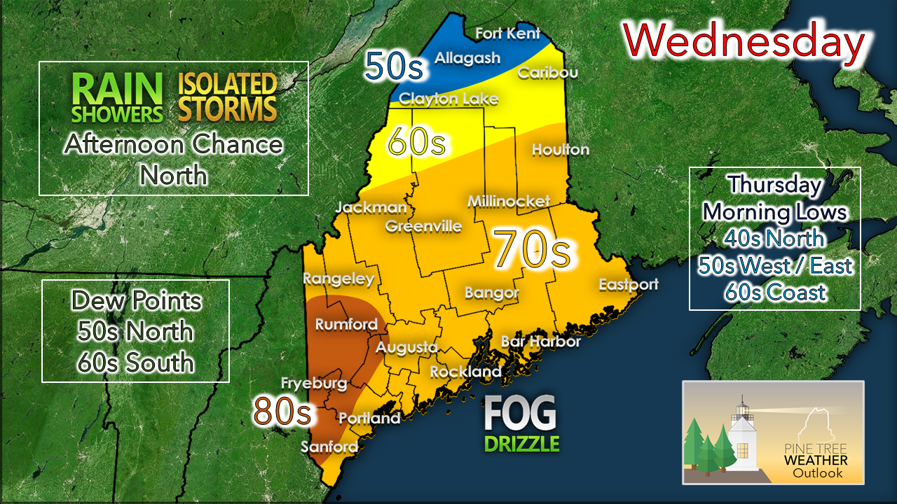 A frontal boundary has become stationary across the central highlands of the state. The result will be much different weather to the north of the front versus the south. For the north, cloudy and cool conditions with chance for showers and isolated thunderstorms are possible. For areas south of the front, sticky dew points and warmer temperatures. With the uptick in dew points, coastal areas appear to deal with fog, especially Casco Bay eastward. Where it is stubborn, temperatures may not get out of the 60s. 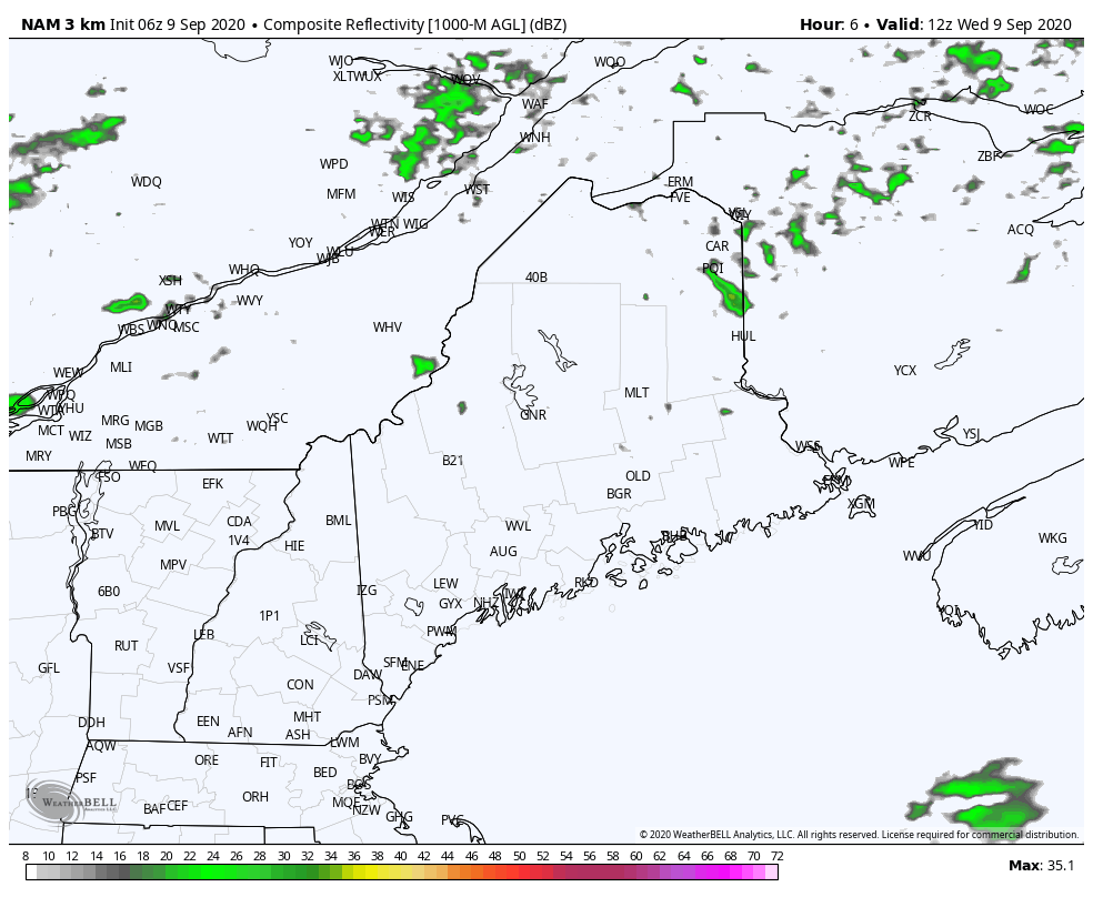 NAM3 model forecast radar idea from 8 AM Wednesday to 8 AM Thursday Showers and storms appear to stay confined in areas to the north of the front. A weak impulse to the south appears to stay out to sea. Scattered showers and perhaps a rumble continue for northern areas through Wednesday night and into Thursday. Front moves out Thursday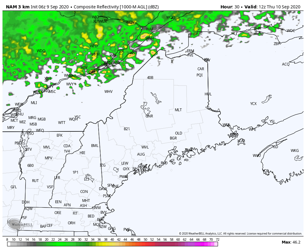 It will take a piece of energy on top of the western ridge near Alaska to race south and east Wednesday to begin to tilt the scale aloft in order to move the frontal boundary out on Thursday. It will be a slow process. The concern I have with this will be for isolated strong to severe storms which could develop Thursday afternoon. I suspect they may be remote. Guidance above hints that eastern areas may have the best chance. This is subject to change as models have flip-flopped in the past day as a result of miscalculating the frontal position and and the temperature / dew point gradient. Showers clear out of the region early Friday once the front is finally kicked offshore. Drier and cooler conditions return to start the weekend. Weekend outlook: dry Saturday, |
| | BE PREPARED WITH A NOAA Weather Radio. For $20-$40, it could provide important information to you when you need it. The weather bands are standard on most public safety scanners, and newer scanner models. Weather radios can be programmed for auto alert. Click here for more information. |
 | ► ► For the latest official forecasts, bulletins and advisories, please check in with the National Weather Service in Gray for western and southern areas, or Caribou for northern and eastern parts of Maine |
** FUNDING NEEDED FOR 2021 **
Thank you for supporting this community based weather information source that is funded by your financial contributions.
Stay updated, stay on alert, and stay safe!
- Mike

Mike Haggett
Kennebunk, ME
Weather-Ready Nation
Ambassador
Certified Weather
Forecaster
Penn State '21
American Meteorological Society
National Weather Association
SKYWARN-CWOP
Matthew 19:26
Please
Support
Pine Tree Weather
In 2024


Archives
July 2024
June 2024
May 2024
April 2024
March 2024
February 2024
January 2024
December 2023
November 2023
October 2023
September 2023
August 2023
July 2023
June 2023
May 2023
April 2023
March 2023
February 2023
January 2023
December 2022
November 2022
October 2022
September 2022
August 2022
July 2022
June 2022
May 2022
April 2022
March 2022
February 2022
January 2022
December 2021
November 2021
October 2021
September 2021
August 2021
July 2021
June 2021
May 2021
April 2021
March 2021
February 2021
January 2021
December 2020
November 2020
October 2020
September 2020
August 2020
July 2020
June 2020
May 2020
April 2020
March 2020
February 2020
January 2020
December 2019
November 2019
October 2019
September 2019
August 2019
July 2019
June 2019
May 2019
April 2019
March 2019
February 2019
January 2019
December 2018
November 2018
October 2018
September 2018
August 2018
July 2018
June 2018
May 2018
April 2018
March 2018
February 2018
January 2018
December 2017
November 2017
October 2017